Lockwood Folly Inlet Dredging
Previously reported – February 2019
USACE dredge boat Murden replaced the Merritt and will be here until February 25th as long as conditions remain favorable. Murden deposits sand nearshore which is more beneficial than the side-caster Merritt, but not as good as putting it on the beach with a pipeline project. The good news is it is placing the sand off our beach, not Oak Island’s. That sand is then in “the system” and will eventually append to our beach – not just fall back in the inlet.
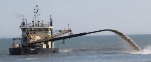 USACE Merritt
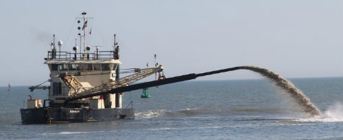
The Merritt is a side-cast dredge that has two drag arms on each side of the vessel that operators lower into the water. The dredge removes sediment from the bottom and pumps it through a discharge pipe outside of the channel and into the direction of the current. It can dredge to a depth of up to 20 feet. The Merritt is especially suited for maintenance of shallow, un-stabilized inlets where larger hopper dredges cannot operate due to strong currents and ocean environment.
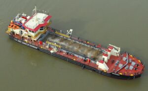
USACE Murden
This vessel will work in the shallow-draft ocean bar channels along the Atlantic Coast. In addition to removing dredged material from the channel it can transport the material to the downdrift beach and deposit it in the surf zone to nourish sand-starved beaches.
Previously reported – January 2020
Lockwood Folly Inlet Navigation Maintenance Project
The Lockwood Folly Inlet Navigation Maintenance Project currently contracted with Goodloe Marine by the US Army Corps of Engineers has been idle since late last week. As of Thursday, the dredge was (and is) on station near Browns Landing with shore pipe stretching from the waterway side of the Holden Beach east end along the dune line heading west past Amazing Grace to near Public Walkway #120 at 317 McCray Street. Some dredging of the crossing has occurred prior to last Thursday with beneficial placement of the material going in the area between Amazing Grace and 317 McCray Street. It is unknown at this time when dredging operations will begin again. We have been informed by the Corps of Engineers that the estimated 200,000 cubic yard excavation will be finished early/mid-January. Please be mindful of the danger that this industrial work zone presents to the general public and stay well clear should you be inclined to visit the east end beach while enjoying this beautiful weather!
Holden Beach Newsletter dated December 26th
Previously reported – March 2020
QUARTERLY LONG-TERM MOA USER’S GROUP MEETING
From: Mike Pearson, Inlet and Beach Protection Board Vice Chair
Todd Horton Chief of Waterways Management
Brennan Dooley Shallow Draft Navigation Project Manager
Wilmington District
Date: 19 February 2020
Brennan Dooley, Shallow Draft Navigation Project Manager, talked about Lockwood Folly and the dredging and sand placement on Holden Beach by Goodloe Marine. He said there was a large amount of sand taken from the bend widener and placed on Holden Beach. He stated that the project would be completed either today or tomorrow. The Corp did their survey of the project on February 18 and the assessment would be done on February 19. The side-caster Merritt is scheduled to return and begin dredging the Inlet on April 1 – 14, 2020. As of February 18, there was still $311,000 in the fund to finish the Merritt job. There also will not be a mobilization charge when the Merritt returns.
Mr. Dooley also gave an update on AIWW maintenance projects for FY 21.
These included:
. • Lockwood River Crossing
. • Lockwood Inlet Crossing
. • Shallotte River Crossing
. • Shallotte Inlet Crossing
The schedule is as follows:
. 1) Issue work in June 2020
. 2) Bids in July 2020
. 3) Award of Contracts in August 2020
Another speaker gave updated rates for the dredges as follows:
. • Murden – $1,700 per hour
. • Currituck – $1,500 per hour
. • Merritt – $2,292 per hour
. • Snell – $1,500 per hour
Rates are based on a minimum10-hour day for scheduling purposes
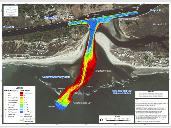
 Sand build up in LWF Inlet causing issues as waterway waits for dredging
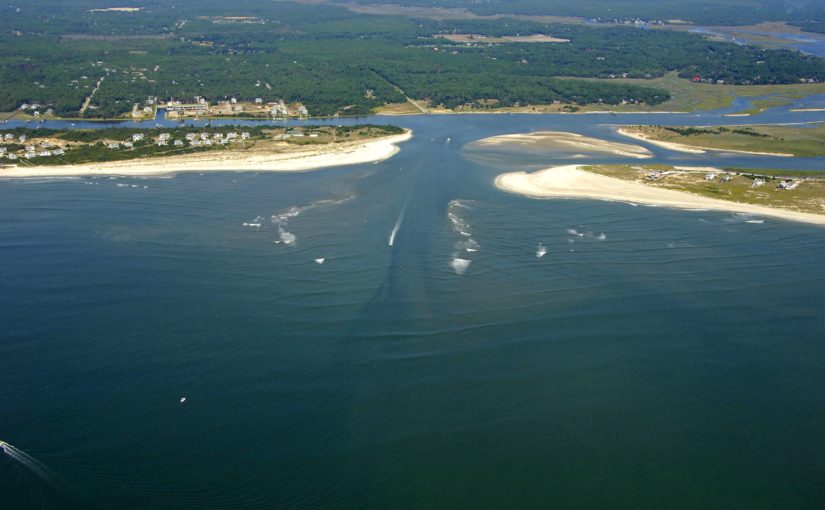
The narrow passage between Oak Island and Holden Beach is even more narrow than usual as sediment buildup has left Lockwood Folly Inlet at critically shallow depths. According to the Feb. 3 survey by the U.S. Army Corps of Engineers, a majority of the inlet is less than six feet deep at low tide, with localized spots barely having three feet of water. “About any boat that’s going to come in and out of there is going to scrub the bottom at the moment,” said Cane Faircloth, who is president of the Lockwood Inlet Association. Faircloth said before Hurricane Dorian, the inlet was in the best shape it has seen in decades after it was dredged following Hurricane Florence. “We had it, it was about eight feet at low tide, and then Hurricane Dorian hit, and it pumped that thing full of sand,” he said. “And that’s just how mother nature works. You know, you have events you have erosion, so we end up with a lot of sand in it, and then now we’ve been playing catch-up.”
Read more » click here
Previously reported – April 2021
 Lockwood Inlet Association warns boaters of broken pipe, other dangers in waterway
After a year of lockdown, many anticipate a busier than ever beach season. For the Lockwood Inlet Association, this raises some concerns. Members of the association, Vice President Ryan Williams and President Cane Faircloth, are cautioning boaters who plan to use the inlet for work or for play as spring break approaches and warm weather lingers. “The biggest factors when it comes to navigating the inlet, definitely the tide and the weather,” Williams said. “If the swells up and you’ve got a hard southwest wind, onshore wind, it’s going to be really rough in there and very dangerous in there right now,” Faircloth added. The two noted several ongoing issues like an unmarked Civil War wreck that could be hazardous to boats passing by but identified two important issues that need immediate attention as the waterway begins to see more traffic. Most recently an exposed, broken pipe has surfaced in the middle of the inlet. Who is responsible for the pipe remains a mystery, but the algae growth on the pipe suggests it has been in the water for quite some time. Additionally, why it’s just now surfacing remains unanswered as well. Some speculated recent dredging events broke the pipe, but the U.S. Army Corps of Engineers says the only impact dredging would cause is lifting sand off the pipe, relieving pressure, and allowing it to rise to the surface. Once notified about the pipe, the U.S. Coast Guard marked it with a buoy, but it remains a hazard for boats traveling at a high rate of speed or with low visibility at night or early in the morning. “It’s something that we can fix and we can save a life doing it,” Faircloth said. “Basically, we need the Corps of Engineers, Brunswick County, and the U.S. Coast Guard to grab the bull by the horns, and let’s remove this.” The U.S. Army Corps of Engineers says there’s not much they can do until an owner of the pipe is identified. When that happens, they can partner with the Coast Guard and write a letter to the owner, notifying them that it needs to be removed. The second pressing issue is the absence of navigational buoys directing boaters. This became a problem after Hurricane Isaias scattered them and they were never replaced by the Coast Guard. “If our inlet is not quite 100%, the coast guard doesn’t want to put the navigational aids in there, but in all reality, the truth is that any navigational aids that we can have are going to greatly help you in the situation,” Williams said. “I mean, it’s like saying the road is not 100% so we’re going to take up the stoplights and stop signs.” A spokesperson for the Coast Guard explained that following recent dredging events, the inlet is not wide or deep enough to allow buoys to be safely installed. However, they remain ready to assess surveys of any future dreading events. In the meantime, Faircloth encourages anyone who will be using Lockwood Folly to go to the U.S. Army Corps of Engineers website to download the most recent survey of the inlet outlining GPS points to help navigate the waterway. The Lockwood Inlet Association members call on the community to get involved, share their concerns with elected officials and make their voices heard, not only for the inlet but for all issues they are passionate about within the community. “The inlet needs the public’s support long before it becomes a problem,” Williams said. “It’s one of our state’s greatest resources, our shallow-draft inlets. It kinda makes who we are with our backwater, our estuaries, our river systems, our fish, our clams, our oysters, all that depends on the inlet,” Faircloth said. WWAY has reached out to Brunswick County for comment on the concerns and a spokesperson confirms they are working to get more information.
Read more » click here
Previously reported – May 2021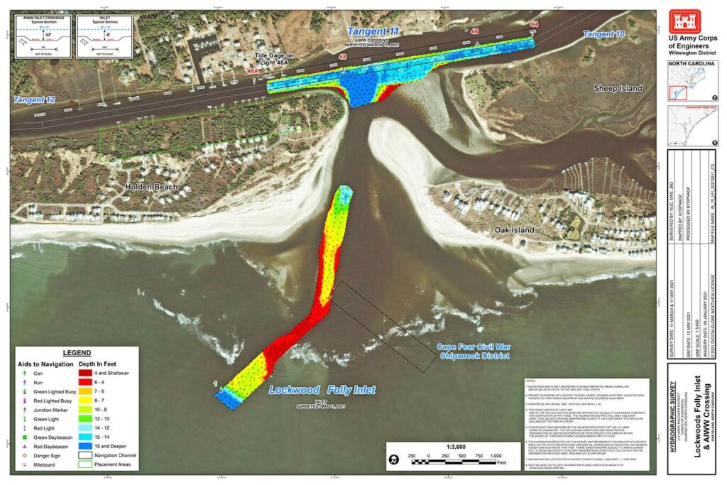 Lockwood Folly Inlet reaches danger point
Brunswick County, Oak Island and Holden Beach have made significant financial commitments in their draft 2022 budgets for maintenance dredging of the badly shoaled Lockwood Folly Inlet. The hope is that other regulatory agencies will solve the immediate issue and regularly schedule the work to avoid potentially hazardous situations like the one on the water today. “We’re in an emergency” said Cane Faircloth, president of the Lockwood Folly Association. Faircloth, a charter captain, said he could not safely transit the inlet in his boat that draws three feet of water. Last week, the U.S. Coast Guard issued an “urgent bulletin” to mariners, warning the inlet was as shallow as two feet at mean low tide. The Coast Guard also removed remaining navigational buoys, stating that they no longer offered realistic assistance to boaters. Brennan Dooley of the U.S. Army Corps of Engineers told the Brunswick Shoreline Protection group last Wednesday that the situation “does not look very good,” with the throat of the inlet badly shoaled, according to a survey last week. “It’s a tough situation as you all know,” he said. “We don’t have a definitive plan yet.” The use of a hopper dredge in 2019 opened the channel and added sand to Oak Island’s west beach. Hopper dredges have claws that reach downward to scoop the sand. They cannot operate in extremely shallow waters, even if a dredge is available. The Corps relies on the Merritt, a sidecast dredge that works more like a lawn mower, pulling sand through a pipe and blasting the sand/water mix to the side. This clears the channel but does not move sediments out of the dynamic inlet system that can quickly shoal. Faircloth said his fear was that if shoaling continued unabated, the Corps may not be able to employ the sidecast dredge Merritt to clear even a marginal channel. Commercial anglers, crabbers, shrimp boats, charter fishermen and recreational boaters all depend on the Lockwood Folly inlet for ready access to the ocean and Long Bay. Dooley said it would be at least 30 days before he expected the Merritt to be here. Members of the group, an intergovernmental ad hoc committee, asked the Corps for an estimate on the costs for annual dredging, which can happen once or twice a year, depending on conditions, budgets and the availability of dredges. Dooley said it would be 2022 before any hopper dredge would be available for Lockwood Folly, which spans the gap between Holden Beach and Oak Island. Dooley said the next available sand from Lockwood Folly, including an inlet widening project, would go to Holden Beach. Masons Creek, Brown Inlet and Snows Cut will also see dredging. The state’s Shallow Draft Inlet Fund picks up most of the costs. Brunswick County will pay half of the “local share.” Oak Island and Holden Beach will split the remaining 25-percent each of the local match, according to Meagan Kaescak, county spokeswoman. Holden Beach has committed $383,000; Brunswick County will contribute $200,000 and Oak Island’s share is $100,000. If the three local government units agree to their draft budgets, “the county will take the lead … in the funding process,” Kaescak stated.
Read more » click here
Previously reported – June 2021
‘People are going to die’: Lockwood Folly Inlet dangerously shallow
As summer approaches, the Lockwood Folly Inlet is reaching the danger zone with alarmingly shallow waters. The U.S. Army Corps of Engineers’ latest survey of the inlet reveals the inlet is severely shoaled, meaning it’s very shallow. According to a bulletin from the Coast Guard, the waters are less than two feet deep at low tide. Lockwood Inlet Association President Captain Cane Faircloth says the inlet is in peril and if something is not done soon visitors who use the inlet may be in danger as well. “People are going to be in the inlet in rougher conditions in their boats who are not from the area, not familiar with this area, and they’re going to get in trouble,” Faircloth said. “Boats are going to capsize, and people are going to die.” The captain draws an analogy to the Cape Fear Memorial Bridge to explain the inlet’s condition. “You can imagine if you tried to go across the bridge and there was half a lane and some cars were just falling off into the water,” Faircloth said. “That’s where we’re at with this infrastructure right now.” It’s not just an environmental concern, but public safety and economic one. Faircloth says not only are boaters at risk of grounding, but people getting caught in rip currents at Oak Island and Holden Beach who depend on water rescue teams who use the inlet and not lifeguards to keep swimmers safe, fishermen, and more all depend on the inlet. “In Tubbs Inlet, the oysters and the clams are starting to die because the inlet does not flow well. It’s really clogged up and lost probably forever,” Faircloth said. “We do not want to see Lockwood go the same route. If we let that inlet close up, the Lockwood Folly River is not going to flow correctly, and all the oysters, clams, and fish are going to start dying.” So what is the solution? Faircloth says the inlet needs another dredging project immediately. Ideally with a hopper dredge vessel. The last time a hopper was used, Faircloth says the channel lasted a year. Although, the only hopper available has prior commitments right now. The Corps of Engineers is working to complete a new survey of the inlet before beginning a new dredge project using the Merritt, a side caster dredge vessel. “It does an okay job, but ideally the hopper dredge is the one that can go in there really remove the sand and create a good long-lasting channel,” Faircloth said. The USACE survey could be completed as early as Thursday. If USACE does not need additional funds from Brunswick County to begin a new project, a spokesman says they will be able to start very soon. If they do need more funding, it could be weeks before they are able to start.
Meagan Kascsak, a spokeswoman for Brunswick County, shared the following statement concerning funding for the project. “Brunswick County’s recommended budget for Fiscal Year 2022 contains another appropriation to the Shoreline Reserve of $200,000, which is the same amount the County appropriated to the reserve the past few years. The reserve has a positive balance at this time and will have enough funds available to support the County’s portion (50% of local match) of an annual project with USACE for the Lockwood Folly Inlet Navigation Channel. It is our understanding that the Towns of Oak Island and Holden Beach also plan to recommend their respective portions (25% each of local match) of such a project for FY22. If all three budget plans are approved as recommended, the County will take the lead with USACE and the NCDEQ Division of Water Resources in the funding process.”
Read more » click here
Follow up: Lockwood Folly Inlet still dangerously shallow
Lockwood Folly Inlet is reaching the danger zone with alarmingly shallow waters. The depth is still decreasing, and the danger is increasing. According to Oak Island Water Rescue a boat capsized in the inlet last weekend. No injuries were reported. Oak Island Water Rescue is advising boaters against using the inlet; especially during low tide. Some areas of the inlet are only two feet deep.
It’s gut wrenching,’
Lockwood Folly Inlet reaches critical level as dredging project sees delays
Lockwood Folly Inlet has a history of filling up with sand and creating a dangerous situation for people on the water, but leaders say they’ve never seen it this bad before. The inlet between Oak Island and Holden Beach has already seen one boat flip this week. While no one was hurt in the crash, Captain Cane Faircloth, the president of the Lockwood Inlet Association, says it’s only a matter of time before it happens again. “It’s gut wrenching to watch people come in and out of it, especially when there’s a swell to watch boats get hung up, you’re just waiting for that moment for the next one to capsize,” said Faircloth. The $600,000 project is already paid for by the Shallow Draft Inlet Fund, the town of Holden Beach, the town of Oak Island, and Brunswick County. The issue is the US Army Corps of Engineers says it’s going to be July before they can get a dredge out there. During the pandemic, dredging ceased, and crews haven’t been able to keep up with the workload since then, explained Faircloth. ”We were hoping there would be a cycle in March, and from March, it got pushed to April. And from April, got pushed to May. In May, we were told in 30 days the dredge should be here,” explained Faircloth. “We’re failing as a state to protect the tourism and the tourists that come to the beach and protecting their lives by giving water rescue a chance to save them.” The inlet is just 1-2 feet deep at low tide, a level so dangerous the Coast Guard removed its navigation buoys and deemed the inlet unsafe. Oak Island Water Rescue Chief Tony Young says they know people are still using the inlet and he’s concerned about safely accessing the area to save someone in trouble. “We would hate to have someone be hurt and waiting for us to get to them and we can’t get there because there’s no safe way for us to approach them,” said Tony Young. “Somebody goes through there at a high speed, and there’s only a foot and a half of water and the motor hits the bottom, that stops the boat. It can go aground or strand them on the sandbar and turn sideways into the waves, and then they roll over — and now there’s a potential for people under a boat or separate from the boat in the breakers. There’s all kinds of bad things that happen in that situation — none of it’s good for the boaters or for the rescuers.” It’s an area that’s historically troublesome, but experts say they’ve never seen it this bad, and they’re pleading with leaders to keep Lockwood Folly Inlet at the top of the priority list to avoid a tragedy. Faircloth is asking people to write to congressional leaders to bring more attention to the issue. ”We’re at the point that we’re going to start losing lives. Is it gonna take a family of six dying out there this weekend to maybe get them to pay attention? Let’s save a life, let’s do what’s right,” added Faircloth. Both organizations and the Coast Guard are warning people to avoid the inlet until the work is complete.
Read more » click here
Previously reported – August 2021
 US Army Corps of Engineers set to complete dredging of dangerously shallow Brunswick County inlet
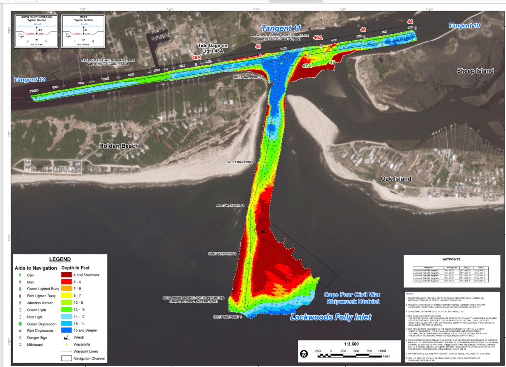
Dredging is finally underway in Lockwood Folly Inlet, an area fishermen, rescuers and recreational boaters alike have been eagerly awaiting the much-needed maintenance. The area between Oak Island and Holden Beach had gotten so shallow that boats were in danger of crashing and flipping over. The inlet was just 1-2 feet deep at low tide, a level so dangerous the Coast Guard removed its navigation buoys and deemed the inlet unsafe. Leaders hoped to get the US Army Corps dredge down this spring, but due to several delays, crews couldn’t make it down until early August. US Army Corps of Engineers says there’s several factors that play into their dredging schedule. Because they only have four vessels that work all across the entire east coast, they have to prioritize projects very carefully. Things grow even more challenging, given the size of the shallow draft inlet. The only ship in the fleet that can clear the channel is the side caster dredge, called the Merritt. Elements like public safety, commerce, and the source of the funding play into the order USACE tackles its projects, but the agency also isn’t immune to equipment breakdowns, COVID-19 delays, storms, or having to respond to emergencies around its coverage area, which stretches from Maine to the Gulf of Mexico. Despite the obstacles, leaders were happy to be back to maintain Lockwood Folly, where they aim to dredge the channel every few months. “We’re here to help. We don’t like it any more than they do. If we could just pick up everything and come right away to all these areas that need us to dredge, we absolutely want to do that, but we’re just — we have constraints that we have to take into consideration, and again we have to prioritize, but if we can get there, we’re going to,” said USACE Chief of Navigation Jeremy Smith. The dredging of the inlet was funded by the town of Holden Beach, Oak Island and Brunswick County. The project cost rang in at $600,000. No federal dollars were used. The dredging kicked off in early August and is expected to wrap up in the next week.
Read more » click here
Previously reported – October 2021
Boaters call for USCG to add navigational buoys back to Lockwood Folly Inlet
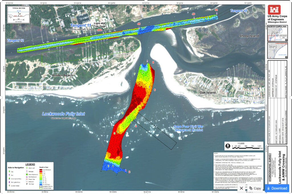
The Lockwood Folly Inlet between Oak Island and Holden Beach is no longer dangerously shallow following a recent dredging project. The U.S. Army Corps of Engineers surveyed the inlet on Monday morning to follow up on the dredging project that was completed on September 5. The Corps said the project was successful and President of the Lockwood Folly Inlet Association Cane Faircloth agrees. “We had a lot of beach erosion from the tropical storms that were passing by and the high tides, but the inlet faired really good from that,” Faircloth said. “It actually got better; it didn’t get worse. That’s always a concern when you have sand eroding from the beaches.” The conditions are a stark difference from earlier this summer. In June, the Coast Guard shared a bulletin saying parts of the inlet were less than two feet deep at low tide. Now the Corps said according to a survey performed just after the dredging project was complete, the channel is seven to eight feet deep and 150 feet wide. “The inlet’s in great shape, we have a great channel, but it’s really important for us to get our navigational aids put back so that boaters can know exactly where this channel is because it’s really shallow to the east or the west of the channel,” Faircloth said. Another concern is the shipwreck close by the inlet that’s only visible at low tide. “Over the past month, we’ve had a couple of boaters hit it. We had one boater hit it this weekend and tear the lower unit of his engine off,” Faircloth said. The Coast Guard is the entity in charge of placing the navigational buoys. A spokesperson said they are awaiting the results of Monday’s survey to see if the project held and it’s safe for them to mark the channel. The spokesperson explained the water must be deep enough for their cutter to place and maintain the buoys. The results of Monday’s survey are expected to be available by Tuesday afternoon. The Coast Guard spokesperson added there are no plans to mark the shipwreck and it has never been marked before. While Faircloth waits and advocates for the return of the buoys, he advises people to follow boaters who are familiar with the inlet to get a track line and remain cautious while navigating the area.
Read more » click here
Lockwood Folly Inlet survey results are in
The latest survey results of Lockwood Folly Inlet have been posted by the U.S. Army Corps of Engineers. On Tuesday afternoon, the Corps posted the results of the survey conducted on Monday morning. The survey was a follow-up from the latest dredging project that concluded on September 5. The Corps said on September 27 that the dredging project was successful, citing a survey performed just after the completion of the project that showed the channel was seven to eight feet deep and 150 feet wide. Lockwood Folly Inlet Association President Cane Faircloth said the inlet is in great shape following the latest dredge. Faircloth said the heavy rainfall helping the inlet rather than hurting it shows the environment is responding well to the project and it’s evident the economy is benefitting judging by the number of fishermen using the inlet. Faircloth said the final piece of the puzzle in making the inlet as safe as possible would be returning to navigational buoys. Returning the navigational aids is up to the U.S. Coast Guard. A USCG spokesperson said they will review the latest survey to determine if they can safely return the buoys because the water must be deep enough for their cutter to place and maintain the buoys.
Read more » click here
Editor’s Note –
It is my understanding that the inlet buoys were put back on October 19th
Previously reported – October 2021
Ready for a fight: How this group wants to preserve a Brunswick County inlet
Cane Faircloth walks the docks at Holden Beach Marina and looks out toward the Lockwood Folly Inlet. Though the inlet itself is not visible, Faircloth, a Holden Beach native and fifth-generation fisherman, has navigated the waters many times. “See that tree line?” he asks, pointing to a cluster of trees. “The inlet’s right around there.” Faircloth has seen the Lockwood Folly Inlet when it was 10 to 12 feet deep throughout and boats of all sizes could pass through easily, and he’s seen it as it is now — nearly impassable. As president of the Lockwood Inlet Association, a local nonprofit organization, he’s working to see the inlet maintained and preserved for future generations. For years, the association has been fighting to have the inlet dredged three to four times a year, but now, members of the association are proposing a more permanent solution: a jetty system between Oak Island and Holden Beach.
Importance of the Inlet
Faircloth spends much of his time on and in the water, and he understands how important the area’s rivers and waterways are for the area. “The Atlantic Ocean’s our greatest resource here at the coast,” he said. “That inlet, as an outlet to the ocean, is another one of your greatest resources.” He explained preserving the inlet achieves three goals: promoting public safety, providing economic stimulus through tourism and fishing, and protecting the environment. When it comes to public safety, the inlet provides easy access to both Oak Island and Holden Beach. Faircloth explained this is important, especially in the summer months when the area is crowded and people are in the water. When it comes to the inlet’s economic importance, Faircloth said it’s crucial for it to be “open and safe” because many tourists use it, and they may not be familiar with the area. Currently, there are four known sunken Civil War-era vessels in the Lockwood Folly Inlet, including two blockade runners. At low tide, part of one of the vessels protrudes above the water. Finally, Faircloth noted when the inlet is open, it performs an important function for the environment. “A healthy inlet improves water quality because it’s getting flushed good,” he said. “The tide goes out, and it carries nasty water out, and then it filters itself out in the big ol’ ocean, and it brings clean, fresh water back in.” Faircloth said last summer, the Lockwood Folly River experienced algae bloom events. Members of the community took the samples to labs for testing, and Faircloth said the tests revealed something called “sea sawdust” because the bacterial colonies look like sawdust floating on the water’s surface. “That was the first time something like that has happened here in my lifetime that I know of,” he said. “But that’s where we’re headed, and if we don’t get this under control, it’s just going to get worse.”
What about dredging?
For years, Lockwood Folly Inlet has been maintained through dredging provided by the U.S. Army Corps of Engineers. But Faircloth said getting the area dredged as often as needed wasn’t easy. It required funding and the availability of a shallow-draft dredge. Faircloth recalled when the inlet association first started, the “battle” was to get the funding for dredging. Then the federal government created the shallow-draft inlet fund in 2021, which allocated money for the maintenance of the state’s shallow-draft inlets. “We got on a really good program, and felt like we won that battle,” Faircloth said. But then he said getting the dredge to the area became an issue. Faircloth said he had a conference call with representatives from the U.S. Army Corps of Engineers who told him the Oregon Inlet dredging project was being given priority. But according to David Connolly, spokesman for the U.S. Army Corps of Engineers Wilmington District, the Lockwood Folly Inlet isn’t being dredged because it has become too shallow. “The issue is that Mother Nature isn’t allowing us to get in there,” Connolly explained. He noted that when it comes to the Lockwood Folly, the Corps uses a side-casting dredge from its shallow draft fleet, usually the Merritt, which Connolly acknowledged is in high-demand right now. He added that funding to dredge the Lockwood Folly Inlet is available, and the Corps will do it once the area is deemed accessible. But Faircloth believes the inlet became inaccessible due to a lack of maintenance, and the association is looking at other ways to address the problem.
A permanent solution
When it comes to keeping the Lockwood Folly Inlet open and navigable, the Lockwood Inlet Association is exploring its options. One solution proposed involved teaming up with the Carolina Beach Inlet Association to purchase a dredge that could be shared, but another solution — a jetty — garnered more support during a recent association meeting. According to Connolly, constructing a jetty will require a permit from the Corps of Engineers. At this point, he said no applications have been submitted for the project. But Faircloth said the decision to advocate for a jetty system was just made in early March. Now, the association will begin approaching local, state and federal officials to advocate for the project. Faircloth acknowledged it may be an uphill battle. “Anytime you do a hard structure, there are going to be people opposed,” he said. “There are environmental groups and law firms, and that’s their job; it’s what they look for. They sue for a living, so there’ll be lawsuits, there’ll be hurdles we have to overcome. But when it comes to protecting the inlet, he’s ready for the fight. “It’ll be a process, and it’ll be a long process,” he said. “But, hey, if we work for it, and we get one in 10 years, it’s worth it.”
Read more » click here
Coast Guard removes buoys from Lockwood Folly Inlet
Serious issues with the condition of Lockwood Folly Inlet were discussed during the March 29 Brunswick Shoreline Protection group’s meeting. Lockwood Folly Inlet is so shoaled that the Coast Guard has removed navigational buoys, and passage is so difficult that U.S. Army Corps of Engineers staff said that except at high tide, even a shallow-draft sidecast dredge like the Merritt cannot safely operate. “This is the worst I’ve seen Lockwood Folly in my career,” said the Corps’ Bob Keistler. The Corps has a $1-million budget to deal with the inlet, but that amount of money won’t begin to pay for mobilization, work and de-mobilization of a large, ocean-going dredge.
Corps leaders said they needed to have more internal discussions before deciding how to proceed. “We need an ongoing solution,” said Brunswick County Commissioner Marty Cooke, adding that a dredge dedicated to the region, a jetty or rock groin terminal are possibilities. “We’ve got to find ways to keep that inlet open,” Cooke said. The channel has a federally authorized depth of 12 feet, plus or minus two feet from high tide.
Members shared concerns about offshore wind energy and heard about an effort to ensure that states receive a 37.5-percent portion of all offshore energy proceeds, be it wind or fossil fuels. Oak Island Mayor Liz White said she was told by energy leaders that if North Carolina fights wind power, they’ll take their investments to South Carolina.
Members also discussed the pros and cons of whether the Grand Strand (South Carolina) transportation planning group should continue planning for expansion and extension of the Carolina Bays Parkway (SC 31) into Brunswick County, or whether that task should shift to the Wilmington-based planning group. Ocean Isle Mayor Debbie Smith said she believed that Brunswick County has and will receive a better plan sticking with the South Carolina-based group. The goal is to tie an interstate-quality highway into U.S. 17 somewhere in Brunswick County.
The group will meet again in the county conference room at 10 a.m. on Wednesday, May 24.
Read more » click here