
Hurricane Season
National Oceanic and Atmospheric Administration (NOAA)
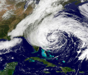
The National Oceanic and Atmospheric Administration (NOAA) defines a hurricane as “an intense tropical weather system with a well-defined circulation and maximum sustained winds of 74 mph (64 knots) or higher.”
Be prepared – have a plan!
For assistance with making an emergency plan read more here »
. 1) FEMA Ready
. 2) American Red Cross Disaster and Safety Library
. 3) ReadyNC
. 4) Town Emergency Information
. 5) HBPOIN Hurricane Emergency Plan
THB – EVACUATION, CURFEW & VEHICLE DECALS
For more information » click here
If the Town declares a mandatory evacuation, PLEASE LEAVE
General Assembly during the 2012 Session, specifically authorizes both voluntary and mandatory evacuations, and increases the penalty for violating any local emergency restriction or prohibition from a Class 3 to a Class 2 misdemeanor. Given the broad authority granted to the governor and city and county officials under the North Carolina Emergency Management Act (G.S. Chapter 166A) to take measures necessary to protect public health, safety, and welfare during a disaster, it is reasonable to interpret the authority to “direct and compel” evacuations to mean ordering “mandatory” evacuations. Those who choose to not comply with official warnings to get out of harm’s way, or are unable to, should prepare themselves to be fully self-sufficient for the first 72 hours after the storm.
No matter what a storm outlook is for a given year,
vigilance and preparedness is urged.
Brunswick County – Hurricanes
Overview
Hurricanes are tropical cyclones that rotate counterclockwise with wind speeds in excess of 74 mph. Most hurricanes form over warm seas near the equator. They are created when the sun heats the ocean surface, causing heated water vapor to rise, condense, and form clouds. These clouds begin to spiral as the earth rotates. More air is pulled underneath and a large vortex is formed. On average, six Atlantic hurricanes develop each year. When a hurricane moves toward coastal areas it often causes severe damage. Strong winds create storm surges, floods, rip tides, and can even spawn tornadoes. As the hurricane moves forward, its right front quadrant is typically where the most devastation occurs. Hurricane season begins June 1 and continues through November 30. Be sure to practice hurricane preparedness and learn about hurricane safety and survival. To assist in being prepared before, during, and after a storm, review the following links for helpful information.
-
- FEMA: How to Prepare for a Hurricane (PDF)
- Ready: Hurricanes
- C. Department of Public Safety: Hurricane Guide (PDF) | Guia Sobre Hurricanes (PDF)
- C. Department of Public Safety: Know Your Evacuation Zone | Brunswick County Evacuation Zones Map (PDF)
- C. Department of Transportation: Evacuation Routes
- C. Cooperative Extension – Brunswick County Center: Hurricane Meal Kits Program
- Brunswick County: Know Your Flood Zone and Flood Risk
- Brunswick County: Hurricane Preparation Checklist (PDF)
- National Weather Service: Latest Weather Briefing for Southeast North Carolina
Hurricane Preparedness Tips We would like to encourage you to start preparing for emergencies and stay #ReadyBrunswick by reviewing the following tips.
STAY INFORMED KNOW THE TERMS KNOW YOUR EVACUATION ZONE MAKE A PLAN KNOW WHO TO CALL GATHER IMPORTANT DOCUMENTS CHECK YOUR INSURANCE PREPARE YOUR HOME LEARN / PRACTICE SAFETY SKILLS SUBSCRIBE TO EMERGENCY ALERTS SIGN UP FOR THE ACCESS AND FUNCTIONAL NEEDS REGISTRY ACCESS LOCAL RESOURCES
Quick Links
NOAA predicts below-normal 2026 Atlantic hurricane season Early preparation essential to staying safe all season Forecasters with NOAA’s National Weather Service are predicting a below-normal hurricane season for the Atlantic basin this year. NOAA’s outlook for the 2026 Atlantic hurricane season, which runs June 1 to November 30, predicts a 35% chance of a near-normal season, a 10% chance of an above-normal season, and a 55% chance of a below-normal season. The agency is forecasting a total of 8-14 named storms (winds of 39 mph or higher). Of those, 3-6 are forecast to become hurricanes (winds of 74 mph or higher), including 1-3 major hurricanes (category 3, 4 or 5 with winds of 111 mph or higher). NOAA has a 70% confidence in these ranges. An average season has 14 named storms with seven hurricanes, including three major hurricanes. “With the most advanced forecast modeling and hurricane tracking technologies, NOAA and the National Weather Service are prepared to deliver real-time storm forecasts and warnings,” said Commerce Secretary Howard Lutnick. “Our experts are integrating cutting-edge tools to ensure communities in the path of storms receive the earliest, most accurate information possible.” “NOAA’s rapid integration of advanced technology, including AI-based weather models, drones, and next-generation satellite data will deliver actionable science to safeguard the lives and livelihoods of the American people,” said NOAA Administrator Neil Jacobs, Ph.D. “These new capabilities, combined with the unmatched expertise of our National Weather Service forecasters, will produce the most accurate forecasts possible to protect communities in harm’s way.” Key factors driving NOAA’s forecast The Atlantic season is expected to be below-normal due to competing factors. El Niño is expected to develop and intensify during the hurricane season, while ocean temperatures in the Atlantic are expected to be slightly warmer than normal and trade winds are likely weaker than average. El Niño conditions tend to support less tropical storms and hurricanes, while warmer ocean temperatures and low winds support a more active year. “Although El Niño’s impact in the Atlantic Basin can often suppress hurricane development, there is still uncertainty in how each season will unfold,” said NOAA’s National Weather Service Director Ken Graham. “That is why it’s essential to review your hurricane preparedness plan now. It only takes one storm to make for a very bad season.” NOAA’s outlook is for overall seasonal activity based on large-scale weather and climate patterns. It does not indicate where or when any storms may affect land as that is determined by short-term and variable weather patterns is not a landfall forecast. “Preparing now for hurricane season — and not waiting for a storm to threaten — is essential for staying ahead of any storm. Visit weather.gov/safety and Ready.gov for important preparedness information,” added Graham. New and enhanced communication products this season
-
- NOAA’s National Hurricane Center (NHC) will implement an improved version of the tropical cyclone forecast cone graphic that will now include tropical storm and hurricane watches and warnings for inland areas for the continental United States, Hawaii, Puerto Rico and the U.S. Virgin Islands.
- NHC will begin testing an experimental version of the tropical cyclone track forecast cone that will capture a greater range of possibilities for the track of the storm by incorporating uncertainties for both direction of movement and timing.
- NHC will provide new products and services for the Hawaiian Islands to include storm surge watches and warnings, and a peak storm surge graphic. These will be publicly available for the main Hawaiian Islands on gov.
Advancements to hurricane analysis and forecasts
-
- NOAA, in collaboration with the Unified Forecast System community, is testing an experimental high-resolution Seasonal Forecast System that utilizes the latest modeling technology and new methods to assess the evolution of the global ocean-atmosphere system. The system is helping forecasters better simulate tropical storms and hurricanes, and more effectively predict the number of hurricanes and major hurricanes.
- NOAA’s Atlantic Oceanographic and Meteorological Laboratory (AOML) is using machine learning to quality-control data collected from tail Doppler radar — a specialized radar system mounted on the back of NOAA’s “Hurricane Hunter” aircraft. This new method gathers more than 25% more meteorological data than the current method and leads to more high-quality data to support structure and wind analysis by forecasters.
Innovative technologies for this year
-
- NOAA’s Office of Water Prediction high-resolution Flood Inundation Mapping (FIM) services provide emergency managers visualizations of those streets and neighborhoods likely to go underwater. FIM covers 60% of the U.S. population and will expand to nearly 100% by late September 2026.
- For the first time, data from small uncrewed aircraft systems (sUAS) will be integrated into NOAA’s hurricane forecast model during the 2026 hurricane season. Scientists from the Cooperative Institute for Marine and Atmospheric Studies (CIMAS) and NOAA’s Atlantic Oceanographic and Meteorological Laboratory (AOML) determined that incorporating sUAS data into NOAA’s Hurricane Analysis and Forecast System (HAFS) can improve hurricane intensity forecast accuracy by 10%.
- NOAA’s Weather Prediction Center launched the experimental Urban Rain Rate Dashboard, a customizable, real-time tool that shows the probability of extreme rainfall a week in advance for more than 60 U.S. cities.
NOAA also issued seasonal hurricane outlooks for the eastern Pacific and central Pacific hurricane basins, with both anticipated to have active seasons. The 2026 Atlantic seasonal outlook will be updated in early August, ahead of the historical peak of the season, which typically extends from mid-September through October. Read more » click here 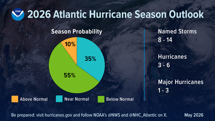
Don’t get complacent with tropical outlook; ‘it only takes one’ The below-normal activity predicted for the 2026 Atlantic hurricane season doesn’t give North Carolinians a pass on preparation this year. “For the Atlantic hurricane season, NOAA is predicting a below-normal season for 2026, with roughly a 55% chance of being below normal, a 35% chance of near normal, and a 10% chance of above normal,” National Oceanic and Atmospheric Association Administrator Dr. Neil Jacobs said during a media conference Thursday morning from NOAA’s Aircraft Operations Center at Lakeland Linder International Airport in Lakeland, Florida. “This equates to eight to 14 named storms with winds at or above 39 miles an hour. Of these, three to six hurricanes with winds at or above 74 miles an hour, and one to three major hurricanes, that’s your Category 3 to 5 with winds at or above 111 miles an hour,” he added. Jacobs is referring to the Saffir-Simpson hurricane wind scale, which categorizes maximum sustained wind speeds for tropical storms. Categories 1 and 2 are windspeeds between 74 and 110 mph, categories 3 to 5 are major hurricanes with speeds from 111 to 157 or higher, according to NOAA. Hurricane season begins Monday, June 1, and ends Nov. 30. “Even though we’re expecting a below-average season in the Atlantic, it’s very important to understand that it only takes one,” Jacobs said, adding there have been Category 5s that made landfall in the past during below-average seasons. During the news conference Thursday morning, Jacobs said that “what’s driving this forecast is largely an El Niño event. There’s a 98% chance of El Niño conditions occurring later this season, and an 80% chance that this El Niño will be moderate to strong.” NOAA National Weather Service Director Ken Graham, who spoke after Jacobs, reiterated that “it just takes one,” and urged the public during the press conference not to “let words like ‘below average’” change the way you prepare. “Now’s the time to start thinking about your hurricane preparedness,” Graham said. “Early preparedness is absolutely everything. Period. End of story. The actions that you take today really get you ready for the hurricane season.” Especially a season like this, “there’ll never be a Hurricane Just-a. We’ll never make that a name. There’s no such thing as just a Cat 1, just a tropical storm, just a Cat 2. That is absolutely not the case,” Graham said. “It doesn’t matter what it is, you got to look at the size, the forward motion, little wiggles matter on the impacts. Even the smallest storm, if it’s slow enough and big enough, it’s going to create catastrophic flooding and storm surge.” Graham said that the public needs to pay attention to every single one of the storm “systems, and the actual impacts, not the category, not the name, but the actual impacts associated with that storm, and that includes the tornadoes, heavy rain, damaging winds, even the high surf and rip currents, as well, including storm surge.” Erik Heden, warning coordination meteorologist in the National Weather Service’s Newport office, said in an interview with Coastal Review that just because the forecast calls for a below-normal season, residents shouldn’t let their guard down. “Just because the outlook says it’s going to be a low year doesn’t mean we won’t be impacted,” he said, adding “It just takes one storm. The graphic says a 55% chance below-normal year, but if we get one storm, it really doesn’t matter what the prediction was, it could be a big deal for us.” Heden also warned in the interview against making decisions based on the category of the storm. “Categories are only wind,” he said. Wind is to be respected, but the other storm impacts are more likely to be more frequent in terms of issues in our area. “Water is what kills people. About 85% of people that die in hurricanes, it’s water related — nothing to do with the wind. but it’s, it’s things like rip currents, storm surge, and flooding. Those are the three things that would get us if we get a storm.” Two years ago, the Southeast faced a potential tropical cyclone that didn’t have a name. No. 8 resulted in almost 20 inches of rain in the Wilmington area, and last year Tropical Storm Chantal produced six to 10 inches of rain in Raleigh. Steven Pfaff, meteorologist-in-charge for the National Weather Service’s Wilmington office, in an email to media partners Thursday morning, also expressed concern that the forecast for below-normal activity can cause messaging challenges because people may misinterpret what it means for any potential local impacts. “All it takes is one storm to define a hurricane season regardless of the outlook,” his emphasis, “Given southeast NC’s and northeast SC’s hurricane history our communities must prepare the same way every year,” Pfaff continued. “Now is the time to prepare for hurricane season and remain vigilant this summer and fall.” Jacobs said during the press conference that for official forecast guidance, go to hurricanes.gov. “June 1 is almost here. Be ready, have a plan, listen to your state and local emergency managers. Preparation is essential. You can learn more at ready.gov,” Jacobs added. Heden told Coastal Review that the best way to stay informed in eastern North Carolina is to remember “if it’s the weather you love, it’s weather.gov,” where there’s up-to-date information, as well as on the office’s website, Facebook or X.
Read more » click here
Previously reported – June 2026
Brunswick County reminds community to prepare for 2026 Atlantic hurricane season June marks the start of the Atlantic hurricane season, which runs from June 1 through Nov. 30, and the National Oceanic and Atmospheric Administration (NOAA) predicts below-normal hurricane activity in the Atlantic basin this year. Brunswick County encourages all community members to start preparing now. For the 2026 Atlantic hurricane season, NOAA is forecasting a range of 8 to 14 total named storms (winds of 39 mph or higher). Of those, three to six are forecast to become hurricanes (winds of 74 mph or higher), including one to three major hurricanes (category 3, 4 or 5; with winds of 111 mph or higher). NOAA has a 70% confidence in these ranges. An average season has 14 named storms with seven hurricanes, including three major hurricanes. The alphabetical list of 2026 Atlantic hurricane names can be found at hurricanes.gov/aboutnames.shtml#atl. Prepare for Hurricane Season with Brunswick County To be ReadyBrunswick is to be responsible for your personal and household preparedness efforts, and to stay alert for any events that could impact you and your loved ones. During the month of June, Brunswick County will be doing a weekly countdown for hurricane preparedness. Each week will focus on different actions you and your household can take to prepare for any tropical activity that may impact the area.
-
- Week 1 (June 7-13): Make a plan. Create and practice a Family Emergency Communication Plan that includes all members of your household and pets. Discuss your household evacuation plan for every member of the household and pets. Review your insurance policies (including flood insurance) to ensure your property is covered for any flooding or natural disasters that could occur.
- Week 2 (June 14-20): Build a kit. An emergency kit is vital for your survival in situations where help might not be easily accessible due to power outages and road damage. When preparing an emergency kit, it is recommended to prepare three to seven days’ worth of medicine, water, and non-perishable food for each person and pet in your home. Make sure you store important documents physically and digitally in secure locations.
- Week 3 (June 21-27): Stay informed. It’s important to plan for multiple ways you will receive credible and accurate information before, during, and after a tropical event. To get updates from Brunswick County, sign up for the ReadyBrunswick Emergency Notification System and follow Brunswick County on social media. Know the terms and categories used by weather professionals and public safety officials for tropical cyclones.
- Week 4 (June 28-July 4): Practice resilience. Take time to learn how to prepare your home/property before, during, and after a storm. Know who maintains roads and how residents play a part. Practice home safety skills to protect your family and property.
For more hurricane preparedness tips from Brunswick County, visit BrunswickCountyNC.gov/hurricanes. Find information on emergency planning and hurricane safety online at ReadyNC.gov or Ready.gov. View updates from the National Hurricane Center, a real-time emergency weather map, and additional online resources at nhc.noaa.gov. Read more » click here Prepare now as hurricane season begins, NC officials urge With this year’s Atlantic hurricane season beginning Monday, which is forecast to have below-normal activity, state officials are urging residents to prepare now for tropical weather impacts because “North Carolinians know that it takes only one storm to affect communities statewide.” Gov. Josh Stein said Monday in a press release marking the start of hurricane season that this time of year brings uncertainty for families across the state. “I encourage all North Carolinians to make a plan now to keep themselves and their families safe in case of a storm,” he explained. “Just as you prepare your family for hurricane season, the state emergency management team is preparing by closely monitoring forecasts, updating response plans, and coordinating with federal and local partners.” The State Emergency Response Team has been preparing for the hurricane season that ends Nov. 30 by reviewing lessons learned from past storms, updating response procedures, meeting with all levels of government, coordinating with the private sector and nonprofit organizations, and conducting exercises. “Preparation is the key to resilience during hurricane season. We encourage all North Carolinians to take time to develop plans and take proactive steps with their loved ones before a storm impacts our state,” N.C. Emergency Management Director Will Ray said Monday. Ray added that preparation includes “creating evacuation plans in case you must leave your home, securing all important documentation in a waterproof container, and checking your insurance policies to make sure you are properly covered. Home and flood insurance are especially important resources in returning to normalcy after a disaster.” Officials recommend taking the following steps to be prepared before disaster strikes:
-
- Put together an emergency kit with up to a week’s supply of nonperishable food, including one gallon of water per person per day, and prescription and over-the-counter medication.
- Be aware of any unique needs for babies, elderly, or disabled members of the household, as well as pets.
- Have multiple ways to receive severe weather warnings such as a weather alert app on your phone, a battery-powered or hand-crank radio or other device and extra batteries to listen to NOAA Weather Radio, or app or radio access to local news outlets.
- If you live along the coast or are planning to visit the beach this season, Know Your Zone! This is how local governments order evacuations along the coast when storm surge is a threat. Visit KnowYourZone.NC.Gov to search by address.
- Establish an emergency evacuation plan and meeting point if your group becomes separated.
- Have a printed list of family member’s phone numbers, social media handles, email addresses, and medical information in case mobile devices lose power or otherwise become disabled.
- Have copies of important papers such as birth and adoption certificates, driver licenses, or military IDs.
- Meet with your insurance agent so you know what is covered should a storm affect your neighborhood.
- Prepare a full list of personal items, along with photos and videos of every room in your home, to help with insurance settlements or tax deductions.
- Be sure you know how to shut off your utilities safely. Water, electricity, and gas are key services that can also cause special problems during an emergency. Do not try to turn the gas back on yourself. Call a trained expert.
- The N.C. Flood Inundation Mapping and Alert Network, or FIMAN, features access over 700 flood gauges across the state. Visit Fiman.NC.Gov to search for the flood gauges closest to your home and to sign up for alerts.
To become involved in preparedness efforts where you live, officials recommend learning about schools, workplace, and neighborhood emergency plans and join in preparedness exercises and drills. Other ways include volunteering with a Community Emergency Response Team, or CERT, to learn about disaster preparedness and receive training in basic disaster response skills or contacting N.C. Volunteer Organizations Active in Disaster at ncvoad.org for more ways to help. For more information on how to prepare for hurricane season, visit ReadyNC.Gov.
Read more » click here
Previously reported – August 2026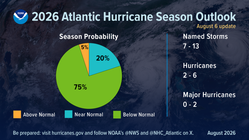 NOAA maintains prediction for below-normal Atlantic hurricane season
Need for U.S. residents to prepare remains
With the climatological peak of hurricane season approaching in early September, NOAA’s prediction for below-normal activity in the Atlantic basin remains. Forecasters from NOAA’s National Weather Service updated today the number of expected named storms to 7-13 (with winds of 39 mph or greater), of which 2-6 could become hurricanes (winds of 74 mph or greater), including 0-2 major hurricanes (winds of 111 mph or greater). These ranges cover the entire season from June 1 through November 30 and are inclusive of the two tropical storms that have already formed. NOAA forecasters predict a 75% chance for below-normal activity, with a 20% chance of a near-normal season, and just a 5% chance of above-normal activity. This updated prediction is similar to the initial outlook issued in May. In the Atlantic basin, a typical hurricane season will yield 14 named storms, of which seven become hurricanes, including three major hurricanes.
Only Gulf storms in the Atlantic Basin so far
To date, the 2026 season has produced two named tropical storms, Arthur and Bertha, and no hurricanes. Tropical Storm Arthur was the first named storm of the Atlantic season. Forming in mid-June in the warm Gulf of America waters off the Texas coast, Arthur brought record rainfall to portions of Louisiana and spawned tornadoes along the Gulf coast. Bertha also formed in the Gulf, originating south of the Florida panhandle before making landfall in St. Bernard Parish, Louisiana. “Inland rainfall is a major cause of damage from tropical storms and hurricanes, as Arthur demonstrated,” said NOAA’s National Weather Service Director Ken Graham. “That’s why it’s important to prepare for every storm that’s projected to impact your area, even if it never reaches hurricane strength.”
Factors influencing the Atlantic hurricane season outlook
For the remainder of the season, tropical storm activity in the Atlantic basin is expected to be tempered by El Nino conditions, which first emerged in the equatorial Pacific in June. El Nino increases wind shear, which tends to prevent tropical storms from forming or from getting stronger once formed. Other less influential factors include temperatures near average in the Atlantic Ocean and a neutral west African monsoon. “When El Nino emerges, it usually becomes the dominant factor in total hurricane season activity, and this El Nino continues to get stronger every month,” said Matt Rosencrans, lead hurricane season forecaster with NOAA’s National Weather Service.“Compared to a mature El Nino, other mechanisms play a smaller role in determining the number and intensity of tropical storms in the Atlantic basin.”
Hurricane outlooks in other ocean basins
Although El Nino tends to limit tropical activity in the Atlantic, it can enhance storm development in the Pacific. NOAA’s outlook for the Eastern Pacific hurricane season remains unchanged with 15-22 named storms, which is above average. So far there have been seven named storms, of which two became hurricanes, including one major hurricane. An above-normal season is also expected in the Central Pacific basin, with 5-13 named storms and tropical depressions.
About NOAA’s Hurricane Season Outlook
NOAA’s Hurricane Season Outlook is for overall seasonal activity and is not a landfall forecast. Landfalls are largely determined by short-term weather patterns, which are only predictable within about a week of a storm potentially reaching land. NOAA’s National Hurricane Center (NHC) provides tropical weather outlooks out to seven days in advance, provides track and intensity forecasts for individual storms and issues watches and warnings for specific tropical storms, hurricanes and the associated storm surge.
Stay informed
Consult the NHC website, hurricanes.gov, for the latest about tropical storm and hurricane activity in the Atlantic and Pacific Ocean basins. You can also follow regular updates from NHC on X at @NHC_Atlantic offsite link and on Facebook. You can also access additional tips and resources to stay safe this season.
Read more » click here
Why the 2026 hurricane season is so quiet; what it means for NC coast So far the 2026 hurricane season, which started June 1, has been very slow. How slow? It’s the quietest start to a hurricane season this century. Why? For most of this hurricane season, the National Hurricane Center’s online map of the Atlantic basin has been showing a surprising image and message. Nothing with this text superimposed on the map: “Tropical cyclone activity is not expected during the next 7 days.” So far the 2026 season, which started June 1, has been the quietest start to a hurricane season this century. There have only been three named storms so far, and they’ve lasted a combined four days. Tropical Storm Arthur brought significant rain to parts of the Gulf coast and Southeastern United States in mid-June, but only after it dissipated. Tropical Storm Bertha in mid-July also brought rain to parts of the Gulf but didn’t cause much of a ruckus. And Tropical Storm Cristobal in August hung around for about a day in the middle of the Atlantic before petering out. Even a pair of tropical disturbances that held the possibility of forming into something or even combining into a bigger system before hitting the Caribbean in mid-August fizzled out. So what’s going on, and how soon could we see Dolly and Edouard?
The 2026 season is both normal and unusual
According to the hurricane center, things aren’t actually that unusual this year. “The first named storm typically forms in mid- to late June, the first hurricane tends to form in early to mid-August, and the first major hurricane forms in late August or early September,” the agency states on its website. The busiest part of hurricane season also runs roughly from mid-August into early October, with the peak day for activity being Sept. 10. But according to another factor, this season is a strange one. The Weather Channel reports that the accumulated cyclone energy, which measures how long storms last and how strong they get, for this hurricane season is unusually low. According to the weather site, the 2026 season is the slowest-starting hurricane season in terms of accumulated cyclone energy since 1998.
Enter El Niño
Across the board, meteorologists say the strengthening El Niño in the equatorial Pacific is playing a large role in squashing tropical activity in the Atlantic basin. El Niño is a natural climate pattern in which surface seawater temperatures in the central and eastern tropical Pacific are warmer than normal. Meaning Little Boy in Spanish, El Niño was originally recognized by fishermen off the coast of South America with the appearance of unusually warm water in the Pacific around Christmas. According to the National Oceanic and Atmospheric Administration (NOAA), there’s a nearly 70% chance it could develop into a “super” El Niño, meaning its impacts could be greater than normal. If a super El Niño does develop, it could supercharge weather events across the world. For the U.S. South, which could mean wetter conditions with more heavy rainfall events this fall and winter − bringing much-needed relief to the ongoing drought situation in much of the Tar Heel State. In a world already cooking hotter than normal thanks to climate change, the weather pattern also could amplify extreme heat already baking much of the world. According to the World Meteorological Organization, 2025 was the third warmest year on record, only trailing 2024 and 2023, with sea-surface temperatures also setting records despite cooling La Niña weather patterns. El Niño can have a significant impact on the severity of the hurricane season in both the Atlantic and the Pacific. In the Atlantic, the weather pattern tends to reduce activity in the tropical Atlantic by bringing on stronger upper-level wind shear and sinking air, hindering the formation of tropical weather systems, while having the opposite effect and boosting activity in the Pacific. The Northwest Pacific has already seen three Category 5 storms this season, and in the Central Pacific Hurricane Lala just finished lashing Hawaii with 90 mph winds.
What happens now?
The latest forecast from Colorado State University is only calling for nine named storms this season, which would be an exceptionally low total, especially given how warm most of the tropical Atlantic is right now. In effect, the Caribbean has largely become a no-go zone for hurricane formation. “That’s a great indication of the power of El Niño, that it can develop in the Pacific, but still have a controlling role in weather patterns half a world away,” said N.C. Assistant State Climatologist Corey Davis. While North Carolina missing out on tropical weather might sound good on paper, it also comes with some other impacts. One of those is a loss of the rainfall such a system would bring to Eastern North Carolina, an area that largely remains in drought or a very dry state as of late August. The region relies on passing tropical weather for much of its summer precipitation that helps farmers and recharges underground aquifers. According to the National Weather Service in Wilmington, the Port City had seen 25.3 inches of rain in 2026 as of Aug. 18. That compares to a normal average of nearly 36 inches. “Wilmington averages more than 8 inches of rain in both August and September, and it’s hard to get that much from the sort of spotty showers and storms we’ve seen in recent weeks,” Davis said. “While we certainly don’t wish for anything tropical, some areas could definitely use the rain to make a dent in this drought.” But on the flip side, El Niño normally brings above-average rainfall to the U.S. Southeast in the fall and winter. During the last strong El Niño in 2015, Wilmington has its wettest October on record and fourth-wettest winter, Davis said. “This all feels like a be-careful-what-you-wish-for sort of situation,” he said. “We need the rain now, but we’ll probably be sick of it in a few months.” Tim Armstrong, a meteorologist with the weather service’s Wilmington office, said even with El Niño hindering storm development across much of the tropics, which doesn’t mean Southeastern N.C. is out of the woods for storm development. “There’s still the subtropical Atlantic we have to watch closely,” he said. “El Niño doesn’t affect shear as much outside of the tropics, so a locally grown storm could more easily develop this fall and bring impacts to the Carolinas.” Past examples of these types of storms include Ophelia in 2005 and Diana in 1984. And the unnamed storm that swamped southern New Hanover County and parts of Brunswick County with 20 inches of rain in 2024 was another one of these storms, he added. Officials also continue to stress to coastal residents that even if it appears to be a relatively quiet season, it only takes one storm arriving on your doorstep to make it a terrible hurricane season. “And our own work suggests that it is very difficult to predict that quantity on a year-to-year basis since you are dealing with the statistics are very small numbers,” said Dr. Michael Mann, a meteorologist and scientist at the University of Pennsylvania. “But we do know that there is an increase over time in the maximum intensity of these storms driven by human-caused warming.”
Read more » click here
Previously reported – September 2026
El Niño has broken Atlantic hurricanes. Now the season is breaking records
No hurricanes have formed in the Atlantic Ocean 103 days into the season, a new record-long wait driven by a beast of an El Niño strangling fledgling storms. Until today, September 11 was the date of the latest first hurricanes — Gustav (2002) and Humberto (2013). Or at least, the latest we know with confidence since 1966, when satellites started tracking hurricanes more accurately. The first hurricane is now more than a month overdue, and there are no prospects for one in the foreseeable future. Thursday marked the statistical peak of the season, and with just five short-lived tropical storms to date, it is now also the least active one since 1950, according to Phil Klotzbach, a hurricane expert with Colorado State University. The only system that made a run at becoming a hurricane was tiny Tropical Storm Edouard on September 1. Edouard was 14 mph shy of hurricane strength and intensifying when it made landfall near the Texas-Louisiana border, cutting it off from the Gulf’s warm water fuel. Looking forward, just over 50% of the entire season’s activity typically occurs after September 10, but El Niño will likely have a say in stifling the Atlantic’s final stretch this year. Last year’s first hurricane showed up in mid-August, and three more spun up in the second half of September. The United States managed to avoid a hurricane landfall last year — if the current quiet season repeats that, it’ll be the first back-to-back years without a hurricane landfall since 2009 and 2010. But it’s worth noting that hurricanes can find windows of opportunity to develop even in the most inactive years – and not a single season since 1966 has gone by without one. Most notably, Category 5 Hurricane Andrew’s catastrophic South Florida landfall in August 1992 happened in a season with just seven storms.
El Niño’s hurricane shredder
September is hurricane season’s peak because storm-fueling warm water is at its most expansive and hottest alongside ripe atmospheric factors. About two to three hurricanes develop this month on average. The results can be dangerous, as 2024’s Helene and 2022’s Ian proved, slamming the US Gulf Coast as Category 4s. Water temperatures are warm enough for hurricanes right now, but El Niño-fueled wind shear, aka tropical-system kryptonite, has soured the situation. Wind shear involves changes in wind speed and direction at different levels of the atmosphere, and it can shred apart anything from budding tropical systems to fully developed hurricanes. The shear has been record-strong this summer across the Atlantic’s so-called main development region, which extends from Africa through the Caribbean, according to Klotzbach. Many storms get their start in this region at the height of the season — mid-August to early October — but this year it’s been nearly shutdown. Tropical Storm Dolly is the only system that has formed in this part of the ocean so far in 2026, and a wall of wind shear ripped it apart just 24 hours later. A few other systems have tried to develop but were also defeated by shear. El Niño’s storm-killing winds will remain an obstacle for development in hurricane season’s back stretch, though that’s no reason to get complacent. Plus, late-season storms tend to develop closer to the US, including in the Gulf and off the Southeast coast. Those areas tend to be affected less by El Niño’s wind shear, so they’ll be watched closely. And as we’ve already learned this year, it doesn’t take a hurricane-strength system to cause significant impacts, particularly in a warming world making tropical systems wetter. Tropical Storm Arthur’s remnants fueled widespread flooding along the central Gulf Coast in June. Cottonport, Louisiana, was drenched by 29.06 inches of rain in 24 hours, which obliterated the previous state record of 22 inches set back in 1962. The record is still being reviewed and certified. Heavy rain from Tropical Storm Edouard less than two weeks ago resulted in dangerous flash flooding and water rescues in eastern Texas. A month’s worth of rain fell in an hour and rainfall totals topped 20 inches in some areas north of Beaumont.
Read more » click here