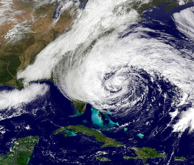
Hurricane Season
National Oceanic and Atmospheric Administration (NOAA)
The National Oceanic and Atmospheric Administration (NOAA) defines a hurricane as “an intense tropical weather system with a well-defined circulation and maximum sustained winds of 74 mph (64 knots) or higher.”
Be prepared – have a plan!
For assistance with making an emergency plan read more here »
. 1) FEMA Ready
. 2) American Red Cross Disaster and Safety Library
. 3) ReadyNC
. 4) Town Emergency Information
. 5) HBPOIN Hurricane Emergency Plan
THB – EVACUATION, CURFEW & VEHICLE DECALS
For more information » click here
If the Town declares a mandatory evacuation, PLEASE LEAVE
General Assembly during the 2012 Session, specifically authorizes both voluntary and mandatory evacuations, and increases the penalty for violating any local emergency restriction or prohibition from a Class 3 to a Class 2 misdemeanor. Given the broad authority granted to the governor and city and county officials under the North Carolina Emergency Management Act (G.S. Chapter 166A) to take measures necessary to protect public health, safety, and welfare during a disaster, it is reasonable to interpret the authority to “direct and compel” evacuations to mean ordering “mandatory” evacuations. Those who choose to not comply with official warnings to get out of harm’s way, or are unable to, should prepare themselves to be fully self-sufficient for the first 72 hours after the storm.
No matter what a storm outlook is for a given year,
vigilance and preparedness is urged.
Previously reported – June 2023
Here’s why this hurricane season could be unusually unpredictable El Niño typically means a quieter hurricane season. As ocean temperatures rise, that could be changing. Under normal circumstances, a quiet Atlantic hurricane season would be a safe bet this year: The global climate pattern known as El Niño is fast developing, and it’s known to diminish tropical cyclone activity in the Atlantic basin. But unusually warm waters — in some areas setting records for this time of year — could cancel that out, creating conditions that could instead fuel an active season of revved-up storms. That means the outlook for tropical cyclone risks is significantly more complicated just ahead of this year’s season beginning June 1. National Oceanic and Atmospheric Administration scientists are expected to factor that uncertainty heavily into a hurricane season forecast that will be released Thursday. Seasonal forecasting is always difficult, but it’s even harder to predict which of the competing influences will win out in the months ahead. “There’s not a lot of historic precedence for this,” said Philip Klotzbach, lead hurricane researcher at Colorado State University. As the season plays out against the backdrop of global warming — which has driven a flurry of storms that intensify quickly into devastating hurricanes — meteorologists remind people that it only takes one extreme storm to turn even a quiet season catastrophic. Unusual ocean warmth raises storm risks Hurricane season is set to begin with an already established trend of ocean warming that has been building since early March. By the heart of hurricane season in late summer and early fall, waters around the Caribbean, Gulf of Mexico and Southeast U.S. coast are always bathwater-like. That warmth could be especially pronounced this year. “Those warm anomalies should, if anything, get stronger,” Klotzbach said. That is bad news for hurricane risks. Warm water is a necessary ingredient for tropical cyclones, and the warmer the water, the greater the potential for extremely strong hurricanes. The warmth translates to increased moisture in the air and greater available energy for a storm to unleash. And the recent ocean warming is grabbing climate scientists’ attention because of both its timing and its widespread appearance. It’s normal for ocean temperatures to rise along the surface of parts of the central and eastern Pacific when El Niño develops — something scientists have been observing off the western coast of South America in recent months. Those changes in sea surface temperatures and in winds across the Pacific have domino effects around the world and can trigger weather extremes. But the ocean warming observed as of late has developed in areas besides those Pacific hot spots — including parts of the Atlantic key for hurricane development. The deep tropics between the Caribbean and West Africa are significantly warmer than normal, something that could encourage any atmospheric disturbances moving into the Atlantic from Africa to organize and strengthen into tropical cyclones, said Brian McNoldy, senior research associate at the University of Miami and hurricane expert for Capital Weather Gang. “When waves come off of Africa, if they get that kick right away, that might help them form a little quicker,” McNoldy said. And though El Niño is known for accelerating planetary warming, the ocean trends are appearing well ahead of the climate pattern shift. Climate scientists don’t expect El Niño to arrive in earnest until some time in the coming weeks or months. El Niño’s influence adds uncertainty The ocean warmth notwithstanding, El Niño typically brings meteorologists a modicum of confidence in a quieter-than-average Atlantic hurricane season. It’s part of the cascade of impacts El Niño can have on weather patterns around the world. El Niño is associated with towering clouds and a rising motion in the lower atmosphere over the central and eastern Pacific, something that changes atmospheric circulation patterns in a way that tends to send dry, sinking air over the central Atlantic. That means diminished activity in the tropical zones is key for cyclone formation and development. The circulation patterns associated with El Niño also tend to bring an increase in wind shear, or a contrast in wind speeds and direction at different altitudes, over the Atlantic. High wind shear makes it difficult for storm systems to organize into classic cyclones with defined eyes surrounded by intense winds. Those factors have prompted some early hurricane season forecasts to call for below-normal storm activity. An average Atlantic hurricane season has about 14 named storms, half of which strengthen into hurricanes, according to data from 1991 through 2020. About three hurricanes a year become “major” storms, with maximum sustained winds of at least 111 mph. Klotzbach’s team at Colorado State’s Tropical Meteorology Project in April cited a budding El Niño in predicting that this season’s tallies would come short of those averages, with 13 named storms, 6 hurricanes and two major hurricanes. But the forecast also noted the outlook contained “more uncertainty than normal.” The team will offer an updated forecast June 1. Some forecasters are eyeing chances for increased tropical activity given the unusually warm Atlantic waters. The Weather Company, which owns weather.com and Weather Underground, and weather data company Atmospheric G2 predicted a near-normal season, with average hurricane activity and 15 named storms. They said in a hurricane season forecast released last month that the ocean temperature trend “gives one pause when relying on the potential El Niño event to keep the season quiet.” Risks of a damaging season persist That hesitation is especially true given caution from scientists over whether El Niño predictions will pan out. It is notoriously difficult to predict its development and trajectory when evaluating climate conditions during the Northern Hemisphere springtime. Even if El Niño forms as expected, weather forecasting models suggest wind shear may remain relatively limited even through the heart of hurricane season, Klotzbach said. And an active and damaging season could still develop if El Niño arrives later than expected, or in a weaker form, he added. Besides, meteorologists urge coastal residents to remain storm-ready even in quieter-than-average hurricane seasons. They stress that conditions can allow for devastating storms to make landfall despite larger climatic trends. That warning could be especially apt given the atmospheric battles meteorologists predict in the tropics between El Niño-fueled wind shear and a surge of ocean warmth. “There’s just no way of knowing which of those is going to be more important in any given week,” McNoldy said. Read more » click here
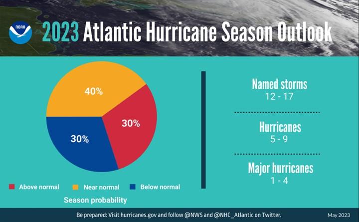 NOAA predicts a near-normal 2023 Atlantic hurricane season El Nino, above-average Atlantic Ocean temperatures set the stage NOAA forecasters with the Climate Prediction Center, a division of the National Weather Service, predict near-normal hurricane activity in the Atlantic this year. NOAA’s outlook for the 2023 Atlantic hurricane season, which goes from June 1 to November 30, predicts a 40% chance of a near-normal season, a 30% chance of an above-normal season and a 30% chance of a below-normal season. NOAA is forecasting a range of 12 to 17 total named storms (winds of 39 mph or higher). Of those, 5 to 9 could become hurricanes (winds of 74 mph or higher), including 1 to 4 major hurricanes (category 3, 4 or 5; with winds of 111 mph or higher). NOAA has a 70% confidence in these ranges. The upcoming Atlantic hurricane season is expected to be less active than recent years, due to competing factors — some that suppress storm development and some that fuel it — driving this year’s overall forecast for a near-normal season. After three hurricane seasons with La Nina present, NOAA scientists predict a high potential for El Nino to develop this summer, which can suppress Atlantic hurricane activity. El Nino’s potential influence on storm development could be offset by favorable conditions local to the tropical Atlantic Basin. Those conditions include the potential for an above-normal west African monsoon, which produces African easterly waves and seeds some of the stronger and longer-lived Atlantic storms, and warmer-than-normal sea surface temperatures in the tropical Atlantic Ocean and Caribbean Sea which creates more energy to fuel storm development. These factors are part of the longer term variability in Atlantic atmospheric and oceanic conditions that are conducive to hurricane development — known as the high-activity era for Atlantic hurricanes — which have been producing more active Atlantic hurricane seasons since 1995. “With a changing climate, the data and expertise NOAA provides to emergency managers and partners to support decision-making before, during and after a hurricane has never been more crucial,” said NOAA Administrator Rick Spinrad, Ph.D. “To that end, this year we are operationalizing a new hurricane forecast model and extending the tropical cyclone outlook graphic from five to seven days, which will provide emergency managers and communities with more time to prepare for storms.” This summer, NOAA will implement a series of upgrades and improvements. NOAA will expand the capacity of its operational supercomputing system by 20%. This increase in computing capability will enable NOAA to improve and run more complex forecast models, including significant model upgrades this hurricane season:
- In late June, the Hurricane Analysis and Forecast System (HAFS) will become operational. HAFS will run this season in tandem with the currently operational Hurricane Weather Research and Forecast Model System and Hurricanes in a Multi-scale Ocean-coupled Non-hydrostatic model, but eventually will become NOAA’s primary hurricane model. Retrospective analysis of tropical storms and hurricanes from the 2020-2022 seasons show that this model has a 10-15% improvement in track forecasts over existing operational models. This new model was jointly created by NOAA’s Atlantic Oceanographic & Meteorological Laboratory Hurricane Modeling and Prediction Program and NOAA’s National Weather Service Environmental Modeling Center.
- The Probabilistic Storm Surge model upgrade on May 2, advances storm surge forecasting for the contiguous U.S. and new forecasts for surge, tide and waves for Puerto Rico and the U.S. Virgin Islands. Forecasters now have the ability to run the model for two storms simultaneously. This model provides forecasters with the likelihood, or probability, of various flooding scenarios including a near worst-case scenario to help communities prepare for all potential outcomes.
Additional upgrades or new tools for hurricane analysis and forecasting include:
- The National Hurricane Center’s Tropical Weather Outlook graphic, which shows tropical cyclone formation potential, has expanded the forecast range from five to seven days.
- Over the last 10 years, flooding from tropical storm rainfall was the single deadliest hazard. To give communities more time to prepare, the Weather Prediction Center is extending the Excessive Rainfall Outlook an additional two days, now providing forecasts up to five days in advance. The outlook shows general areas at risk for flash flooding due to excessive rainfall.
- The National Weather Service will unveil a new generation of forecast flood inundation mapping for portions of Texas and portions of the Mid-Atlantic and Northeast in September 2023. These forecast maps will extend to the rest of the U.S. by 2026. Forecast flood inundation maps will show the extent of flooding at the street level.
NOAA will continue improving new and current observing systems critical in understanding and forecasting hurricanes. Two projects underway this season include:
- New small aircraft drone systems, the deployment of additional Saildrones and underwater gliders, and WindBorne global sounding balloons. These new technologies will advance our knowledge of hurricanes, fill critical data gaps and improve hurricane forecast accuracy.
- The modernization and upgrade of the Tropical Atmosphere Ocean buoy array. The upgrade will provide additional capabilities, updated instruments, more strategic placement of buoys and higher-frequency observations. Data from these buoys are used to forecast El Nino and La Nina, which can influence hurricane activity.
“As we saw with Hurricane Ian, it only takes one hurricane to cause widespread devastation and upend lives. So regardless of the number of storms predicted this season, it is critical that everyone understand their risk and heed the warnings of state and local officials. Whether you live on the coast or further inland, hurricanes can cause serious impacts to everybody in their path,” said FEMA Administrator Deanne Criswell. “Visit ready.gov or listo.gov for readiness resources and get real time emergency alerts by downloading the FEMA App. Actions taken today can save your life when disaster strikes. The time to prepare is now.” NOAA’s outlook is for overall seasonal activity and is not a landfall forecast. In addition to the Atlantic seasonal outlook, NOAA also issues seasonal hurricane outlooks for the eastern Pacific and central Pacific hurricane basins. NOAA’s Climate Prediction Center will update the 2023 Atlantic seasonal outlook in early August, just prior to the historical peak of the season.
Read more » click here
A guide for hurricane season in the Wilmington area: Supplies, shelters, evacuations and more It’s never too early to prepare for hurricane season. And as the Atlantic hurricane season begins on June 1, here are things to know to stay safe in the Wilmington area. Evacuations Twenty coastal counties in North Carolina have established predetermined evacuation zones to simplify the coastal evacuation process in the event of an emergency. Everyone living or vacationing in North Carolina’s coastal areas should know your zone.
Evacuations:
Preparing for a hurricane — What you need to know about evacuations
Hurricane kit
Everyone usually remembers food and water, but what about medicine, insurance policies (home and auto), and other important documents? Here is a list of supplies and documents you should have ready in your “go bag” or supply kit, according to FEMA and the American Red Cross.
Supplies:
Are you prepared for a hurricane? Here’s a list of supplies to have in your hurricane kit.
Pet friendly shelters
If you need to evacuate and want to take your pets with you, several emergency management services will open emergency shelters at local schools if a hurricane should hit.
Shelters:
Where to find pet friendly hurricane shelters in the Wilmington area
Hurricane watch or warning?
Living in coastal North Carolina, most people know when hurricane season begins. But it’s also important to know the difference between a hurricane watch and a hurricane warning.
Watch or warning:
What’s the difference between a hurricane watch and warning?
Here’s more on the difference.
Wilmington’s worst storms
Take a look back at hurricane activity for the worst storms to ever hit the Wilmington area. Names such as Hazel and Florence will forever be etched to the region. Also check out the list of names for the 2023 hurricane season.
Worst hurricanes:
What are the 5 worst hurricanes to ever hit the Wilmington area?
2023 names:
Here’s the list of names for the 2023 Atlantic hurricane season.
Up-to-date weather
There are several webcams following weather on the coast. Here are a few of them. You can also follow a storm from its beginnings to now with this storm tracker.
Weather webcams:
Check the latest weather conditions via these webcams along the NC coast
Track the storm:
See where the storm is in real time
Read more » click here
Previously reported – August 2023
NOAA boosts Atlantic hurricane forecast, leans toward busy season
The midseason outlook update is a dramatic shift toward what experts warn may be an above-average season.
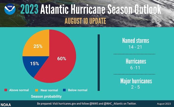
The National Oceanic and Atmospheric Administration released an updated hurricane season outlook Thursday morning that now speaks of a high likelihood of an above-average hurricane season. The midseason update reflects a dramatic shift in NOAA’s thinking as the agency joins a number of others in expecting a busy season. Last week, Colorado State University shared its updated outlook, projecting a total of 18 named storms, including the five that have already formed in the open Atlantic. It says the United States has a nearly fifty-fifty shot at being hit by a major hurricane, rated Category 3 or higher. AccuWeather also nudged its forecast upward. Hurricane season, which officially runs from June 1 to Nov. 30 and on average peaks around Sept. 15, traditionally does not perk up until mid- to late August. The season to date has featured four named storms. And an unnamed subtropical storm spun up hundreds of miles off the East Coast in mid-January. Forecasts are highlighting the potential for a season similar to last year’s.
Here are NOAA’s latest projections:
- 14 to 21 named storms the 12-17 named storms predicted in late May. This includes the four tropical and subtropical storms that have formed, as well as Hurricane Don in July.
- 6 to 11 hurricanes, as opposed to the May prediction of 5 to 9
- 2 to 5 major hurricanes, boosted from 1 to 4.
The Hurricane National Center also now estimates a 60 percent chance of an above-average season — double the predicted odds in May. It also says there is a 25 percent chance of a near-normal season. It puts the odds of a below-average season at only 15 percent. At present, only the European Center for Medium-Range Weather Forecasting, which oversees the operation of the “Euro” model, paints a picture of a near-average season. Its analysis suggests that 8.5 more named storms are likely. Regardless, there is a growing cause for concern, as noted by the forecasters behind NOAA’s outlook. “During active years, there’s a doubling in the chance of a hurricane hitting the East Coast of the U.S. compared to an average or below-average season,” said Matthew Rosencrans, a meteorologist and the director of NOAA’s Climate Test Bed, at a news conference Thursday.
What are the key drivers of this season’s hurricane forecast?
Meteorologists tasked with predicting how the season will play out have been juggling two deeply conflicting signals: record-high Atlantic sea-surface temperatures and a strong El Niño. High sea-surface temperatures are crucial in helping spawn and intensify hurricanes. This year, the waters are red-hot and reaching records. “One of the local conditions in the Atlantic that we monitor is the sea-surface temperature,” Rosencrans said. “The June and July sea-surface temperatures in the Main Development Region were the warmest since 1950, about [2.2] degrees above normal.” He said the formation in June of Bret and Cindy in the “Main Development Region” — the tropical zone between the eastern edge of the Caribbean Sea and western Africa — probably was highly influenced by the hot seas. “Tropical development in the deep tropics in June or July is usually a harbinger of a more active season,” he said. The water temperatures will raise the odds of rapid intensification of the storms that do form, posing the danger of big lurches in strength in any potentially landfalling hurricane. Working against a busy hurricane season is the ongoing El Niño weather pattern. El Niño, which begins as a warming of water temperatures in the eastern tropical Pacific, results in sinking air and hostile upper-level winds over the Atlantic. The nascent El Niño isn’t going away any time soon. “Odds are in excess of 95 percent that the ongoing El Niño will continue into autumn,” Rosencrans said. However, his team expects a delayed start to the arrival of En Niño-esque conditions — the same ones usually inhibitive of an above-average hurricane season. With El Niño’s true fingerprint taking a while to show up, the exceptionally warm ocean waters may help kick things into unimpeded overdrive. “Changes of El Niño appear to be emerging later than expected,” Rosencrans said. “If those changes move in quickly, then activity could be [near the] lower end of our predicted ranges.” In predicting seasonal hurricane activity, forecasters also consider the Saharan air layer, a stretch of hot, dry and sandy air that wafts over the Atlantic and suppresses storm growth. “Saharan air outbreaks do peak in June and July, and then fade off in area and intensity as the season goes on,” Rosencrans said, suggesting that this phenomenon will increasingly become less of an impediment to storms. An active West African monsoon, which provides a source of moisture and disturbances that can become the seeds for hurricanes, also could elevate storm activity. “During 2023, the West African monsoon rains have been robust, but the winds have been near normal, giving a bit of a mixed signal,” Rosencrans said. The bottom line NOAA is exhibiting confidence that the high sea-surface temperatures will supersede the effects of El Niño, favoring a busy season. Irrespective of how many storms do spin up, it only takes one hitting a populated zone to leave a mark. “Landfalls are only predictable up to about one week from a storm reaching a coastline,” Rosencrans said. “People should be busy preparing for the storms that this forecast implies.”
Read more » click here
Previously reported – August 2023
THE 5 HURRICANE CATEGORIES, EXPLAINED It’s a number attached to every hurricane, crucial to emergency response teams and city officials to mobilize preparedness: the Saffir-Simpson Hurricane Wind Scale, characterized by five categories. The scale only measures one component of a hurricane: the wind. Each category is divided by a range of wind speeds, estimating potential damage and impacts on properties. This year, the National Oceanic and Atmospheric Administration predicted an above-normal hurricane season. Record-breaking warm water in the Atlantic has increased tropical storm and hurricane activity. Five hurricanes have swept through the Atlantic this year. Before the season concludes at the end of November, the Atlantic may experience a total of six to 11 hurricanes. Three of the hurricanes so far this year were considered major — Category 3 or above — and NOAA predicts that there could be up to two more. An imperfect scale The scale used to include other impacts like storm surge ranges and flooding, but they were removed to reduce public confusion, according to the National Hurricane Center. “Now the wind is the scale’s strength — but also its weakness,” said Gina Eosco, the division chief and social science expert at the Weather Program Office for NOAA. “It ends up missing the myriad of other risks that are oftentimes more serious in a hurricane, such as storm surge,” she said. Scientists and forecasters are still learning how individuals perceive and adjust to risks as threats develop during hurricanes, Eosco said. Some experts hypothesize that people anchor to the storm category and don’t adjust for other risks. “It is very misleading because somebody may not evacuate for a tropical storm or a Category 1 hurricane, but we have seen time and time again that these storms have had a lot of impact,” said Jennifer Collins, a hurricane researcher at the University of South Florida. Each storm has its own personality, and there isn’t always a direct correlation between category and damage. This means a Category 1 hurricane could be more devastating than a Category 3. “A simple one, two, three, four, five scale is not sufficient to communicate the threat that a hurricane brings,” said Jeff Masters, a hurricane expert for Yale Climate Connections. Here is other extreme weather that’s associated with a hurricane: STORM SURGE As a hurricane barrels across the open ocean, strong winds drive the water forward. Once the water reaches the shore, it combines with normal tides and creates the storm surge. Storm surge is the leading cause of hurricane-related deaths in the United States, according to the National Weather Service. “The Hurricane Center realized this is a problem because [the scale] didn’t speak to storm surge in particular — which is the threat that kills the most people from hurricanes — so they introduced a separate storm surge watch and storm surge warning product,” Masters said. In some cases, storm surge is responsible for the most hurricane destruction. Hurricane Ike made landfall as a Category 2 hurricane with walloping sustained winds of 110 mph in September 2008, with hurricane-force winds extending 125 miles from the center. But the wind wasn’t what caused the most damage. The storm had a surge of more than 20 feet, the largest storm surge on record for a Category 2 hurricane. Imagine rushing water the height of two basketball hoops stacked on top of each other barreling toward homes, cars and buildings. The storm claimed 195 lives and resulted in $30 billion in damage. It wasn’t even considered a major hurricane. RAIN AND INLAND FLOODING Not to be mistaken with storm surge, the other main cause of flooding during a hurricane is rain. While some inland communities assume they are spared from the wrath coastal communities endure, storm impacts can occur tens to hundreds of miles outside of the storm’s eye. During hurricanes, excessive amounts of rain cause streams and creeks to overflow their banks and clog storm drains and sewage systems, which results in devastating flooding. Hurricane winds weaken as they move over land, but the torrential rains don’t stop. Inland cities, with vast amounts of concrete and impermeable surfaces, also have a high risk of excess runoff and flooding. Hurricane Harvey made landfall in Texas as a Category 4 with maximum wind speeds surpassing 130 mph in August 2017. But by the next day, the hurricane fell to a Category 1 and eventually was considered a tropical storm. Yet the storm wasn’t done. Instead of moving on, Harvey stalled over Texas for days. In the end, the slow-moving storm unloaded 33 trillion gallons of water along the Gulf of Mexico and became the second costliest storm in U.S. history. An unprecedented 60 inches of rain fell in Southeast Texas, producing devastating and deadly flash and river flooding, according to the Weather Service. A year after Harvey, Florence made landfall as a Category 1 hurricane and brought destructive flooding across the Carolinas. Florence was responsible for the heaviest rainfall ever recorded from a tropical cyclone in both South Carolina and North Carolina, according to the Hurricane Center. Twenty-two people died due to direct impacts from Florence — 17 deaths of them from inland flooding. Damage totals exceeded $20 billion. Florence, which peaked as a Category 4 hurricane over the ocean, had been downgraded to a tropical storm when it dropped most of its rain. TORNADOES The last risk people worry about when thinking about hurricanes is tornadoes. The severe spin from hurricane systems, coupled with atmospheric instability and wind shear, creates perfect conditions for tornadoes. Both hurricanes and tornadoes cause damage due to strong rotating winds, so it’s not surprising that a large rotating system could also produce twisters. Tornadoes generally start within thunderstorms embedded in the outer rain bands of hurricanes, according to the Weather Service. But sometimes they form near the eyewall, which is the ring of destructive winds that surround the storm center. In September 2004, Hurricane Ivan unleashed a damaging storm surge, inland flooding and powerful wind gusts spanning Alabama to Florida. But that wasn’t the end of its impact. The Category 3 hurricane was most notable for its unprecedented tornado outbreak. About 120 twisters touched down from Florida to Pennsylvania — across nine different states — over the course of three days. Virginia alone experienced a record-breaking 38 tornadoes across the state. Overall, the tornadoes from Ivan were responsible for eight deaths and 17 injuries, according to the Weather Service. SIZE The size of a hurricane matters. A larger hurricane will tend to produce a more severe storm surge as well as stronger winds and heavier rain over a larger area. But the storm category doesn’t take size into account. One of the ways hurricanes expand is through a process known as an eyewall replacement cycle. During this process, the inner eyewall collapses as a much larger outer eyewall forms around it, often resulting in a bigger hurricane. Not long before striking land last year, Hurricane Ian underwent an eyewall replacement cycle, enlarging the storm substantially. It made landfall as a Category 4 hurricane very close to where Hurricane Charley did at roughly the same intensity in 2004. But Ian was a much larger storm and thus had more severe impacts. Ian’s catastrophic surge, record-breaking inland flooding and damaging winds propelled it to become the costliest hurricane in Florida’s history and the third-costliest hurricane in the United States, according to the Hurricane Center.
Here are some tips to help you stay safe this hurricane season:
- Prepare your emergency supply kit: Include nonperishable food, a generator in case of power outages, important identification information, essential medications and cash.
- Save water: Fill your tub, sinks or containers with drinking water in case public water systems become compromised.
- Protect your home: Board windows with storm shutters or plywood to protect them from wind damage.
- Secure your surroundings: Clear any outdoor objects that could be picked up by the wind.
- Trim weak tree branches that could fall on your home or car. Make sure drains, gutters and downspouts are cleared to prevent flood risks or mold.
Previously reported – November 2023
Hurricanes have always struck the shores of the United States. But in recent decades, the combination of climate change and growing coastal population has made them far more damaging – particularly in one corner of the Atlantic coast. Roughly 150 Atlantic hurricanes have approached or directly hit the United States in the last seven decades. Gulf Coast regions like coastal Louisiana and Florida frequently encounter powerful hurricanes, of course. But some of the most hurricane-prone parts of the country lie further northeast, on the Carolina coast. Between 2016 and 2022, the Carolinas were hit by five hurricanes: Matthew, Florence, Dorian, Isaias and Ian. At the crossroads of these hurricanes lie the metro areas of Myrtle Beach, S.C., and Wilmington, N.C. These two metros, known for their striking coastlines, have been regularly battered by hurricanes this century. They also have something else in common: Both are among the fastest-growing coastal metros in the United States since 2000. Why do so many people decide to move here despite the risks? And what does that mean for everyone else?A Beautiful Place That Has a Dragon’: Where Hurricane Risk Meets Booming Growth The hurricanes keep coming, and the people, too: The fastest-growing places along the Atlantic coast this century are also among the most hurricane-prone. Between 2016 and 2022, the five hurricanes that hit the Carolinas cost the two states over $33 billion in damages in current dollars, displaced hundreds of thousands of people and led to the deaths of more than 90. There’s every reason to expect more damage in coming years: A warming climate adds moisture to the air, unlocking the potential for wetter and more powerful storms. And rising sea levels make storm surges more damaging and coastal flooding more frequent. And the newcomers will keep coming: One 2022 study projected that by 2050, population growth will increase the number of Americans exposed to flooding nearly four times as much as climate change will alone. Simply put, there are many more people living along the paths of hurricanes than ever before. And this booming coastal population is, by many accounts, a larger contributor to rising hurricane risks than climate change. “It’s always climate change plus something, and we’re moving more people into harm’s way than out,” said Kathie Dello, North Carolina’s state climatologist. Local officials say they are struggling to keep up with the growth. They can try to manage the floodplain, communicate the risks, regulate construction and prepare for disasters. But the one thing they can’t seem to do is stop people from moving here. Many retirees are drawn to the Carolinas’ beaches and waterways, moderate temperatures and low taxes. Between 1990 and 2020, the number of people 65 and older grew by nearly 450 percent combined in Horry County, S.C., and adjoining Brunswick County, N.C. When Gail Hart moved from Arizona to retire in Wilmington, N.C., in 2017, she hadn’t considered the hurricane risk. “I wanted to be near a beach,” she said. “I wanted a community.” The next year, Hurricane Florence made landfall in the Wilmington metro area. Many neighborhoods flooded. In some places, three feet of water entered homes. Emergency officials rescued over a thousand residents. Ms. Hart evacuated. She was fortunate: Her home suffered only minor wind damage. But the experience changed her view of living there. She installed storm shutters and a generator and bought flood insurance. And yet, like so many others, she has stayed despite the storm risks. “I don’t let it affect my life unless there’s a hurricane coming,” she said. Ms. Hart is far from alone. When she arrived, there were about a dozen homes in her retirement community. Today there are over 500. In a retirement community being built across the road, acres of pine forests have been cleared to develop homes along the Cape Fear River. Nearby, marshland with ghost forests of dead trees was up for sale as “riverfront condo land.” Wilmington is part of New Hanover County, the most densely populated of the state’s coastal counties. Nearly 40 percent of its homes risk being severely affected by flooding in the next 30 years, according to the First Street Foundation. “There’s just not a lot of area left,” said Steven Still, director of emergency services for the county. “So, you’re developing in the fringe areas.” The escalating costs of storms raise a difficult question for these growing coastal communities: How do you balance growth with safety? The combination of climate change and development in risky areas is making it “a huge challenge” to keep residents safe, said Amanda Martin, North Carolina’s chief resilience officer. It’s not just that people are moving to hurricane-prone areas. The growth itself can make flooding worse. Cutting down trees and paving over wetlands takes away open land that would otherwise absorb rainfall. “We just seem to be going through this vicious cycle that is becoming more vicious with the amount of people and infrastructure we put in these areas,” Mr. Still said. Federal law permits people to build in flood zones, so long as they meet certain minimum standards. In return, the government offers them flood insurance through a federal program that is over $20 billion in debt — largely due to escalating hurricane damages. While the National Flood Insurance Program was originally intended to discourage floodplain development, in practice it has done the opposite by removing a lot of the financial risk involved, said Jenny Brennan, a climate analyst at the Southern Environmental Law Center. States have a few options to discourage people from building in flood zones. They can create more stringent building requirements, or they can buy up and preserve undeveloped land. But these measures are expensive and rely on political will or the willingness of landowners to sell. One way that states can move residents out of harm’s way is by offering to buy out their homes and permanently converting that land to open space. But a study this year found that for every home bought out in North Carolina between 1996 and 2017, more than 10 new ones were built in the state’s floodplains. The growth also makes it more difficult to evacuate when storms strike. In these booming coastal counties, residents and local officials say that roads and bridges are not keeping pace with the growth. “Our biggest problem is our infrastructures not being able to keep up,” said David McIntire, the deputy director of emergency management for Brunswick County, the fastest-growing coastal county in North Carolina this century and part of the Wilmington metro. The state has undertaken a multiyear project to add two lanes to Highway 211, the main evacuation route for the region. Mr. McIntire said the state and local departments were “having to play catch-up” after years of failing to plan ahead. In neighboring New Hanover County, his counterpart Mr. Still is grappling with a shortage of affordable housing, which he said was making it “exponentially difficult” to shelter people displaced by disasters. After a disaster, the surge in demand for short-term housing drives up already high rents. Poorer residents often rely on the state and local governments for assistance with evacuation and housing. The problem lies in where to house them. “If there is zero housing availability in the community right now,” Mr. Still said, “where do you put 100,000 people?” The housing crunch is one of many tensions playing out between wealthy coastal communities and those who live nearby. April O’Leary lives in Conway, S.C., an inland city in Horry County, a half-hour drive from Myrtle Beach. The county makes up the Myrtle Beach metro area, which was the fastest-growing coastal metro nationally between 2000 and 2020 and is one of the fastest-growing places in the country annually. And the growth is projected to continue. Horry County is large and flat: Nearly a quarter of its land lies within a floodplain. After Hurricane Florence made landfall, it took about a week for the rainwater to flow down to Conway. But the water stayed for over a week. “It sits for a while and it just destroys everything,” Ms. O’Leary said. Water entered her home, flooding the first floor and a bedroom. Her husband and son evacuated to Myrtle Beach, while she stayed for a few days to document the floods. Afterward, there were large piles of debris lining street after street in her neighborhood, filled with ruined flooring, kitchen cabinets and bathroom fixtures. When her son’s elementary school reopened and he saw the devastation in the neighborhood, she said he stopped smiling and became quieter for months. After the flooding, Ms. O’Leary founded Horry County Rising, a political organization that campaigned for the county to adopt stricter regulations for floodplain construction. Much of the flooding in the Carolinas during Hurricane Florence occurred outside of federal flood zones, where few people have flood insurance or homes that are protected from flooding. In 2021, the county expanded its flood zone boundaries to include places that flooded during Hurricane Florence. And it required new homes built there to have their lowest floor three feet above the high water mark. The changes applied to all unincorporated parts of the county. But they faced pushback from local developers because of raised building costs. The county recently voted to lower the height requirements to two feet, after legal pressure from a developer. The flooding and growth also affect rural communities that have been rooted in the Carolinas for generations. In Bucksport, S.C., a small inland town in Horry County, Kevin Mishoe is a third-generation farmer and former chair of the Association for the Betterment of Bucksport. He said the newer building codes would pay dividends in future floods, but they would also make home ownership far more expensive for people in lower-income communities like Bucksport. Bucksport sits between two major rivers, nestled against wetlands and tidal forests. Mr. Mishoe lives with his wife in a mobile home that flooded during Hurricane Matthew in 2016 and Hurricane Florence in 2018. Mr. Mishoe says he believes banks are denying loans to residents because of their location in a floodplain, a phenomenon he called “bluelining.” Meanwhile, he said, locals are being “bombarded” with offers from developers and private equity companies to buy their land. “All of a sudden land that you’re telling us is almost worthless because you’re in a flood zone, everybody’s trying to buy,” he said. The area is considered prime real estate because of its access to water. This year, the county expressed support for a highway that would connect Myrtle Beach to inland parts of the county. The highway is expected to cut through Bucksport and its adjoining wetlands and bring added development to the region. The town’s residents emphatically do not want to sell their land, Mr. Mishoe said. Their ancestors have held on to this land for generations, and they intend to stay. Bucksport’s flooding problem began in 2015. But there are coastal Carolina communities that have endured regular hurricanes for over a century. Karen Willis Amspacher lives on Harkers Island in Carteret County, N.C. — one of the most hurricane-prone counties in the country. The island is part of a string of low-lying rural communities near the Outer Banks that locals call Down East. The communities are connected by Highway 70, a dredged road that floods several times a year. Ms. Amspacher is a fifth-generation resident of the island and the director of the Core Sound Waterfowl Museum. There are a lot of newer residents, she said, moving into large houses on stilts, with generators and flood insurance. Some houses are second homes or vacation properties. The construction boom has driven up costs for locals. “The fear and threat of sea level rise or storms doesn’t hinder any of it,” she said. While the new homes may be safer, Ms. Amspacher said, many of the newcomers are isolated from the emotional trauma that her community experiences during a hurricane. “This is a piece of property to them,” she said. “It’s not their family inheritance. It’s not their home. It’s not where they hope their children will stay and grow up.” Ms. Amspacher has had to evacuate her home in three past hurricanes. But she’s not planning to leave for the next one. She said staying during storms was a way to protect property from damage and was part of her community’s cultural identity. “These hurricanes make these communities what we are,” she said. Back in Wilmington, Sharon Valentine is also no stranger to hurricanes. She owned a large animal farm near Fayetteville, N.C., which was devastated by Hurricane Fran in 1996. So, when she and her partner decided to retire in Wilmington’s Del Webb community in 2017, they knew the risks. Many others have followed since. “There’s a mass migration down here,” she svvv Atlantic hurricanes intensifying faster, more frequently, research finds The list of major hurricanes that rapidly intensified before hitting the United States in recent years is long and memorable: Harvey, Irma, Maria, Michael, Laura, Ida, Ian and Idalia. All of those storms, starting in 2017, developed explosively over the Atlantic Ocean. Generally, this rapid escalation is increasingly recognized as part of a global phenomenon related to climate change and its associated warming of ocean waters — but until the past couple of years, the Atlantic’s inclusion in the trend was somewhat murkier. Now, research shows that this rapid intensification is on the rise across the Atlantic basin at multiple time scales. The author of a study published Thursday, Andra Garner, an assistant professor at Rowan University in New Jersey, also highlights regions in which this intensification has become more likely, such as the western Caribbean Sea. “These findings really just serve to quantify a phenomenon that is very much expected in a warmer climate,” Garner told The Washington Post. “The increased likelihood for hurricanes to transition from weak storms into major hurricanes in 24 hours or less was particularly striking.” Studies like this will be crucial in unlocking puzzles regarding intensity fluctuations in tropical cyclones. Even as hurricane forecasting improves, intensity and rapid changes in storms are still poorly understood but understanding them is critical for saving lives and property. The United States has seen a remarkable increase in economic damage from hurricanes over the past century because of coastal development and population growth, according to the National Hurricane Center. When it comes to hurricanes and climate change, the most readily detectable shifts can be seen in higher storm surges — or the wind-driven increase in ocean water above normally dry land at the coast — because of sea level rise, heavier rainfall rates and greater occurrence of the most intense types of storms. The study of rapid intensification — generally defined as an increase in peak winds of at least 35 mph in 24 hours — is still in relative infancy. While many storm studies are limited to a portion of an ocean basin, Garner examined the North Atlantic as a whole. Using historical data from 1971 to 2020, she was able to assess intensification rates achieved by storms during a 12-, 24- or 36-hour window. By breaking the data into periods running from 1971 to 1990, 1986 to 2005 and 2001 to 2020, Garner was able to examine intensity changes in different eras. “Results indicate broad increases to observed [tropical cyclone] intensification rates over the past 50 years,” the study finds. More specifically, Garner finds that the average maximum intensification rates increased by nearly 29 percent in the 12-hour window, more than 27 percent at 24 hours and more than 26 percent in the 36-hour time frame. Putting actual wind numbers behind the idea makes it even more stark. The study finds that it’s now as likely that storms see peak winds increase at least 57 mph in 24 hours as it was during a 36-hour period several decades ago. It was also found that certain parts of the Atlantic have become more prone to rapid intensification in recent decades. This includes much of the Caribbean Sea, Atlantic waters to the west of northern Africa, and areas near the southeastern U.S. coast. While changes are perhaps most notable in the 24-hour period, they are relatively consistent across all windows. On the flip side, Garner’s research suggests that rapid intensification has become less frequent in much of the Gulf of Mexico and in an area just east of the Caribbean. Nonetheless, the toasty waters are still engines of explosive development. Another study published in Geophysical Research Letters recently also addressed the topic. “Comparing 1980-2000 versus 2001-2021 … the basin wide number of [rapid intensification] events has increased by 36%,” the authors wrote in the article published in late August. That separate research found that the increase in rapid intensification was greatest in the Yucatán and western Caribbean Sea region, as well as the southern North Atlantic. More broadly, it was concluded that intensification rates are faster in the western Atlantic than other parts of the basin. Sam Lillo, a meteorologist and co-developer of a computer program that can analyze tropical activity worldwide — the Tropycal package in the programming language Python — generally concurs with the findings. “I can definitely corroborate that there has been an increase in the number of category 1 hurricanes rapidly intensifying to category 3 and stronger,” Lillo wrote in an email. “The message in the western Caribbean is certainly consistent.” Lillo thinks the trends are driven largely by warmer waters but pointed to additional factors such as whether La Niña (which tends to increase storm activity) or El Niño (which tends to decrease storm activity) is dominant. In most of the regions frequented by tropical cyclones, Lillo calculated an increase in rapid intensification at 24-hour time scales. Garner, the author of the study released Thursday, hopes to continue investigating changes in intensification, given its increased importance in discussions about preparation. Opening the study up to other basins may also be possible.
- Read more » click here
Hurricanes have always struck the shores of the United States. But in recent decades, the combination of climate change and growing coastal population has made them far more damaging – particularly in one corner of the Atlantic coast. Roughly 150 Atlantic hurricanes have approached or directly hit the United States in the last seven decades. Gulf Coast regions like coastal Louisiana and Florida frequently encounter powerful hurricanes, of course. But some of the most hurricane-prone parts of the country lie further northeast, on the Carolina coast. Between 2016 and 2022, the Carolinas were hit by five hurricanes: Matthew, Florence, Dorian, Isaias and Ian. At the crossroads of these hurricanes lie the metro areas of Myrtle Beach, S.C., and Wilmington, N.C. These two metros, known for their striking coastlines, have been regularly battered by hurricanes this century. They also have something else in common: Both are among the fastest-growing coastal metros in the United States since 2000. Why do so many people decide to move here despite the risks? And what does that mean for everyone else? A Beautiful Place That Has a Dragon’: Where Hurricane Risk Meets Booming Growth The hurricanes keep coming, and the people, too: The fastest-growing places along the Atlantic coast this century are also among the most hurricane-prone. Between 2016 and 2022, the five hurricanes that hit the Carolinas cost the two states over $33 billion in damages in current dollars, displaced hundreds of thousands of people and led to the deaths of more than 90. There’s every reason to expect more damage in coming years: A warming climate adds moisture to the air, unlocking the potential for wetter and more powerful storms. And rising sea levels make storm surges more damaging and coastal flooding more frequent. And the newcomers will keep coming: One 2022 study projected that by 2050, population growth will increase the number of Americans exposed to flooding nearly four times as much as climate change will alone. Simply put, there are many more people living along the paths of hurricanes than ever before. And this booming coastal population is, by many accounts, a larger contributor to rising hurricane risks than climate change. “It’s always climate change plus something, and we’re moving more people into harm’s way than out,” said Kathie Dello, North Carolina’s state climatologist. Local officials say they are struggling to keep up with the growth. They can try to manage the floodplain, communicate the risks, regulate construction and prepare for disasters. But the one thing they can’t seem to do is stop people from moving here. Many retirees are drawn to the Carolinas’ beaches and waterways, moderate temperatures and low taxes. Between 1990 and 2020, the number of people 65 and older grew by nearly 450 percent combined in Horry County, S.C., and adjoining Brunswick County, N.C. When Gail Hart moved from Arizona to retire in Wilmington, N.C., in 2017, she hadn’t considered the hurricane risk. “I wanted to be near a beach,” she said. “I wanted a community.” The next year, Hurricane Florence made landfall in the Wilmington metro area. Many neighborhoods flooded. In some places, three feet of water entered homes. Emergency officials rescued over a thousand residents. Ms. Hart evacuated. She was fortunate: Her home suffered only minor wind damage. But the experience changed her view of living there. She installed storm shutters and a generator and bought flood insurance. And yet, like so many others, she has stayed despite the storm risks. “I don’t let it affect my life unless there’s a hurricane coming,” she said. Ms. Hart is far from alone. When she arrived, there were about a dozen homes in her retirement community. Today there are over 500. In a retirement community being built across the road, acres of pine forests have been cleared to develop homes along the Cape Fear River. Nearby, marshland with ghost forests of dead trees was up for sale as “riverfront condo land.” Wilmington is part of New Hanover County, the most densely populated of the state’s coastal counties. Nearly 40 percent of its homes risk being severely affected by flooding in the next 30 years, according to the First Street Foundation. “There’s just not a lot of area left,” said Steven Still, director of emergency services for the county. “So, you’re developing in the fringe areas.” The escalating costs of storms raise a difficult question for these growing coastal communities: How do you balance growth with safety? The combination of climate change and development in risky areas is making it “a huge challenge” to keep residents safe, said Amanda Martin, North Carolina’s chief resilience officer. It’s not just that people are moving to hurricane-prone areas. The growth itself can make flooding worse. Cutting down trees and paving over wetlands takes away open land that would otherwise absorb rainfall. “We just seem to be going through this vicious cycle that is becoming more vicious with the amount of people and infrastructure we put in these areas,” Mr. Still said. Federal law permits people to build in flood zones, so long as they meet certain minimum standards. In return, the government offers them flood insurance through a federal program that is over $20 billion in debt — largely due to escalating hurricane damages. While the National Flood Insurance Program was originally intended to discourage floodplain development, in practice it has done the opposite by removing a lot of the financial risk involved, said Jenny Brennan, a climate analyst at the Southern Environmental Law Center. States have a few options to discourage people from building in flood zones. They can create more stringent building requirements, or they can buy up and preserve undeveloped land. But these measures are expensive and rely on political will or the willingness of landowners to sell. One way that states can move residents out of harm’s way is by offering to buy out their homes and permanently converting that land to open space. But a study this year found that for every home bought out in North Carolina between 1996 and 2017, more than 10 new ones were built in the state’s floodplains. The growth also makes it more difficult to evacuate when storms strike. In these booming coastal counties, residents and local officials say that roads and bridges are not keeping pace with the growth. “Our biggest problem is our infrastructures not being able to keep up,” said David McIntire, the deputy director of emergency management for Brunswick County, the fastest-growing coastal county in North Carolina this century and part of the Wilmington metro. The state has undertaken a multiyear project to add two lanes to Highway 211, the main evacuation route for the region. Mr. McIntire said the state and local departments were “having to play catch-up” after years of failing to plan ahead. In neighboring New Hanover County, his counterpart Mr. Still is grappling with a shortage of affordable housing, which he said was making it “exponentially difficult” to shelter people displaced by disasters. After a disaster, the surge in demand for short-term housing drives up already high rents. Poorer residents often rely on the state and local governments for assistance with evacuation and housing. The problem lies in where to house them. “If there is zero housing availability in the community right now,” Mr. Still said, “where do you put 100,000 people?” The housing crunch is one of many tensions playing out between wealthy coastal communities and those who live nearby. April O’Leary lives in Conway, S.C., an inland city in Horry County, a half-hour drive from Myrtle Beach. The county makes up the Myrtle Beach metro area, which was the fastest-growing coastal metro nationally between 2000 and 2020 and is one of the fastest-growing places in the country annually. And the growth is projected to continue. Horry County is large and flat: Nearly a quarter of its land lies within a floodplain. After Hurricane Florence made landfall, it took about a week for the rainwater to flow down to Conway. But the water stayed for over a week. “It sits for a while and it just destroys everything,” Ms. O’Leary said. Water entered her home, flooding the first floor and a bedroom. Her husband and son evacuated to Myrtle Beach, while she stayed for a few days to document the floods. Afterward, there were large piles of debris lining street after street in her neighborhood, filled with ruined flooring, kitchen cabinets and bathroom fixtures. When her son’s elementary school reopened and he saw the devastation in the neighborhood, she said he stopped smiling and became quieter for months. After the flooding, Ms. O’Leary founded Horry County Rising, a political organization that campaigned for the county to adopt stricter regulations for floodplain construction. Much of the flooding in the Carolinas during Hurricane Florence occurred outside of federal flood zones, where few people have flood insurance or homes that are protected from flooding. In 2021, the county expanded its flood zone boundaries to include places that flooded during Hurricane Florence. And it required new homes built there to have their lowest floor three feet above the high water mark. The changes applied to all unincorporated parts of the county. But they faced pushback from local developers because of raised building costs. The county recently voted to lower the height requirements to two feet, after legal pressure from a developer. The flooding and growth also affect rural communities that have been rooted in the Carolinas for generations. In Bucksport, S.C., a small inland town in Horry County, Kevin Mishoe is a third-generation farmer and former chair of the Association for the Betterment of Bucksport. He said the newer building codes would pay dividends in future floods, but they would also make home ownership far more expensive for people in lower-income communities like Bucksport. Bucksport sits between two major rivers, nestled against wetlands and tidal forests. Mr. Mishoe lives with his wife in a mobile home that flooded during Hurricane Matthew in 2016 and Hurricane Florence in 2018. Mr. Mishoe says he believes banks are denying loans to residents because of their location in a floodplain, a phenomenon he called “bluelining.” Meanwhile, he said, locals are being “bombarded” with offers from developers and private equity companies to buy their land. “All of a sudden land that you’re telling us is almost worthless because you’re in a flood zone, everybody’s trying to buy,” he said. The area is considered prime real estate because of its access to water. This year, the county expressed support for a highway that would connect Myrtle Beach to inland parts of the county. The highway is expected to cut through Bucksport and its adjoining wetlands and bring added development to the region. The town’s residents emphatically do not want to sell their land, Mr. Mishoe said. Their ancestors have held on to this land for generations, and they intend to stay. Bucksport’s flooding problem began in 2015. But there are coastal Carolina communities that have endured regular hurricanes for over a century. Karen Willis Amspacher lives on Harkers Island in Carteret County, N.C. — one of the most hurricane-prone counties in the country. The island is part of a string of low-lying rural communities near the Outer Banks that locals call Down East. The communities are connected by Highway 70, a dredged road that floods several times a year. Ms. Amspacher is a fifth-generation resident of the island and the director of the Core Sound Waterfowl Museum. There are a lot of newer residents, she said, moving into large houses on stilts, with generators and flood insurance. Some houses are second homes or vacation properties. The construction boom has driven up costs for locals. “The fear and threat of sea level rise or storms doesn’t hinder any of it,” she said. While the new homes may be safer, Ms. Amspacher said, many of the newcomers are isolated from the emotional trauma that her community experiences during a hurricane. “This is a piece of property to them,” she said. “It’s not their family inheritance. It’s not their home. It’s not where they hope their children will stay and grow up.” Ms. Amspacher has had to evacuate her home in three past hurricanes. But she’s not planning to leave for the next one. She said staying during storms was a way to protect property from damage and was part of her community’s cultural identity. “These hurricanes make these communities what we are,” she said. Back in Wilmington, Sharon Valentine is also no stranger to hurricanes. She owned a large animal farm near Fayetteville, N.C., which was devastated by Hurricane Fran in 1996. So, when she and her partner decided to retire in Wilmington’s Del Webb community in 2017, they knew the risks. Many others have followed since. “There’s a mass migration down here,” she said. Ms. Valentine organizes annual hurricane training for these newer arrivals. The community members have evacuation plans and look out for one another. She, too, said the local infrastructure hadn’t kept up with growth. There are two small bridges on either end of River Road that serve as the main evacuation routes for her community. She is concerned that they may flood in a major storm. “If we really ever have a bad one, we’re going to have to get out of here,” Ms. Valentine said. Still, when she thinks about all the newcomers, she sympathizes with their reasons for moving here. “It is a beautiful place that has a dragon emerge periodically,” she said. “And so, you weigh your risks.”
Read more » click here
Previously reported – December 2023
2023 Atlantic hurricane season ranks 4th for most-named storms in a year NOAA advances modeling and observation capabilities during the season The above-normal 2023 Atlantic hurricane season, which officially ends on Nov. 30, was characterized by record-warm Atlantic sea surface temperatures and a strong El Nino. The Atlantic basin saw 20 named storms in 2023, which ranks fourth for the most-named storms in a year since 1950. Seven storms were hurricanes and three intensified to major hurricanes. An average season has 14 named storms, seven hurricanes and three major hurricanes. Hurricane Idalia was the only U.S. landfalling hurricane in 2023. It made landfall as a category-3 hurricane on Aug. 30 near Keaton Beach, Florida, causing storm surge inundation of 7 to 12 feet and widespread rainfall flooding in Florida and throughout the southeast. Tropical Storm Ophelia made landfall as a strong tropical storm with 70 mph winds on Emerald Isle, North Carolina, on Sept. 23 causing widespread heavy rainfall, gusty winds and significant river and storm surge flooding in portions of eastern North Carolina. Hurricane Lee made landfall as a post-tropical cyclone in Nova Scotia, Canada, on Sept. 16. Swells generated by Lee caused dangerous surf and rip currents along the entire U.S. Atlantic coast. Strong winds with hurricane‑force gusts from Lee caused extensive power outages in Maine and in parts of Canada. The 2023 Atlantic seasonal activity fell within the NOAA Climate Prediction Center’s predicted ranges for named storms and hurricanes in the August updated outlook. “The Atlantic basin produced the most named storms of any El Nino influenced year in the modern record,” said Matthew Rosencrans, lead hurricane forecaster at NOAA’s Climate Prediction Center — a division of NOAA’s National Weather Service. “The record-warm ocean temperatures in the Atlantic provided a strong counterbalance to the traditional El Nino impacts.” The eastern Pacific basin hurricane season was also above normal with 17 named storms, of which 10 were hurricanes and eight of those major hurricanes. From Aug. 16 to 21, Tropical Storm Hilary brought widespread heavy rainfall and flooding to Southern California, with some areas receiving up to 600% of their normal August rainfall. Hilary resulted in the first ever issuance of Tropical Storm Watches and Warnings for the Southern California coastline by NOAA’s National Hurricane Center. In addition, the Center distributed key hazard focused messages for Hilary in Spanish through the agency’s new language translation project. Hurricane Otis made landfall near Acapulco, Mexico, on Oct. 25 as a category-5 hurricane with sustained winds of 165 mph. Otis holds the record as the strongest landfalling hurricane in the eastern Pacific after undergoing rapid intensification in which wind speeds increased by 115 mph in 24 hours. The central Pacific basin had a near-normal season with four tropical systems traversing the basin. Hurricane Dora, a category-4 storm, passed south of Hawaii in early August, marking the first major hurricane in the central Pacific basin since 2020. The strong gradient between a high pressure system to the north and Dora to the south was a contributing factor to the wind-driven, fast-moving wildfires in Hawaii. Hurricane season activity for the eastern Pacific and central Pacific fell within predicted ranges. “Another active hurricane season comes to a close where hazards from the storms extended well inland from the landfall location,” said NOAA National Hurricane Center Director Michael Brennan, Ph.D. “This underscores the importance of having a plan to stay safe whether you’re at the coast or inland.” NOAA’s new Hurricane Analysis and Forecast System helped National Hurricane Center forecasters improve intensity predictions this season. NOAA’s intensity forecasts showed Hurricane Idalia as a major hurricane impacting the coast of Florida as early as Aug. 28. This lead time gave those in threatened areas more time to prepare and respond, and there were no storm surge fatalities from Idalia despite storm surge inundation of as much as 12 feet above ground level in some areas. Further, extending the National Hurricane Center’s tropical weather outlook product from five to seven days, this season provided emergency managers more time to prepare and stage resources before a storm. NOAA’s hurricane research and response This season, NOAA Hurricane Hunter aircraft flew 468 mission hours to collect atmospheric data that is critical to hurricane forecasting and research, passing through the eye of a hurricane 120 times and deploying over 1,400 scientific instruments. Since 2020 through this 2023 season, NOAA’s two Lockheed WP-3D Orion have flown 40% more hurricane mission flights than the preceding four years (2016-2019). NOAA celebrated the first operational launch of a Black Swift drone from a NOAA WP-3D Orion to gather atmospheric data in and around Hurricane Tammy. Further, the first successful coordination of a low-flying drone (Anduril’s Altius 600), atmospheric profilers (dropsondes), and ocean profilers (bathythermographs) also launched from a NOAA WP-3D Orion. Observations and information from these deployments are being evaluated to determine the feasibility of using the data to help with hurricane forecasting in the future. NOAA’s Beechcraft King Air flew 28 mission hours to collect aerial imagery used for emergency response after Hurricanes Idalia and Lee. Following Hurricane Idalia, NOAA’s National Ocean Service provided support to enable safe maritime navigation, gathering survey data for 36.8 linear nautical miles and identifying 29 potential obstructions along Florida’s coastal waterways. NOAA also worked to identify hazards caused by capsized vessels, damaged docks and piers, parts of homes and other types of marine debris, and shared findings with Florida’s debris task force following Hurricane Idalia. NOAA’s geostationary and polar-orbiting weather satellites provided vital information for monitoring and forecasting the hurricanes and tropical weather that threatened our lives and property this season. Forecasters used one-minute geostationary satellite imagery to assess structure changes during the rapid intensity of storms such as Idalia, Lee and Otis. NOAA’s polar-orbiting satellites orbit the Earth from pole to pole 14 times a day, providing full global coverage twice daily. Throughout the hurricane season, these satellites made sophisticated and precise observations of the atmosphere, ocean and land, which were critical to developing daily and 3-5 day forecasts. The National Hurricane Center and Central Pacific Hurricane Center Tropical Cyclone Reports for 2023, including synoptic history, meteorological statistics, casualties and damages, and the post-analysis best track, will be published on the 2023 Tropical Cyclone Report site in March 2024. NOAA’s Climate Prediction Center, a division of the National Weather Service, will issue its 2024 hurricane seasonal outlook in May 2024. The hurricane season officially begins on June 1.
Read more » click here
Previously reported – January 2024
Why a hot Atlantic has hurricane forecasters very worried Hurricane season is still more than three months away, but in parts of the tropical Atlantic, it feels like we might as well already be in the thick of it. Across a strip of ocean where many cyclones are born, February ocean temperatures are closer to what scientists expect in July. The ominous warmth is stirring concerns of yet another hyperactive Atlantic hurricane season. Seven of the last eight seasons have been above normal. Last year, similarly unusual warmth fueled a storm season that was significantly more active than meteorologists might have expected given the presence of the El Niño climate pattern, which emerged last spring and creates conditions that tend to inhibit Atlantic cyclone formation. As meteorologists look ahead to this hurricane season, which begins June 1, they see an increasing likelihood that a La Niña pattern will replace El Niño by late summer or early fall. That is another bad sign for the U.S. coastline — La Niña is associated with active patterns in the tropical Atlantic. It’s still too early to say whether the warmth will persist into hurricane season, or when La Niña might arrive. But, especially together, the trends suggest that an active season could be difficult to avoid, said Michael Lowry, a meteorologist with WPLG-TV in Miami and a former National Hurricane Center scientist. “There’s plenty of time ahead before we get to the meatiest part of the hurricane season,” Lowry said. “But a lot’s going to have to change … for forecasters to feel much more comfortable going into hurricane season.” A persistent trend of record warmth Last spring, the strongest climate signal scientists know of — El Niño — gave every indication of a slowdown in Atlantic hurricane activity in the summer and fall. El Niño’s signature is a surge of warm waters and towering clouds in the central and eastern Pacific. It triggers changes in atmospheric circulation that, on the other side of the planet, can make it harder for tropical storms to form and strengthen: Areas of high pressure with sinking air are more common over the Atlantic, and wind shear, when wind speed and direction vary at different altitudes, increases. The expectation of El Niño prompted National Oceanic and Atmospheric Administration forecasters to predict a mostly typical Atlantic hurricane season, a downgrade from years of increased storm activity. But as El Niño developed, and unusual warmth appeared well beyond the Pacific zones the climate pattern is known for, forecasters warned that a quieter season was far less than certain. By August, it became clearer: The ocean warmth was likely to counteract El Niño’s typical effect in the Atlantic, and NOAA upgraded its forecast. The season ended up with about 20 percent more activity than average, as measured by a statistic known as accumulated cyclone energy. Now, with a new tropical weather season ahead, Atlantic temperatures are perhaps even more remarkable. Why meteorologists have reason for concern In a zone of the Atlantic known as the main development region for hurricanes, sea surface temperatures are running well above normal — and 1.1 degree Fahrenheit (0.6 degrees Celsius) higher than in any other year on record, said Philip Klotzbach, a tropical meteorologist at Colorado State University. If that trend persists into hurricane season this summer, it could mean a ripe environment for tropical waves flowing from Africa to develop into cyclones. “Basically, it is the perfect recipe for hurricanes to form and strengthen,” Alejandro Jaramillo, a meteorologist at the National Autonomous University of Mexico, said in an email. “The warmer waters provide extra fuel available for hurricanes, potentially leading to the formation of stronger storms.” One factor behind the Atlantic warmth: weak winds over the ocean, Klotzbach said. That discourages evaporation, which would allow the waters to cool by transferring heat into the air. Models suggest weaker-than-normal winds continuing into March, Klotzbach said. Beyond that, longer-term models predict that surface temperatures will remain elevated, and that by the heart of hurricane season, from August through October, precipitation will be above normal across the tropical Atlantic, something that suggests a strong pattern of waves flowing off Africa, Klotzbach said. If those predictions come to pass, “I’d expect a very busy season in store,” he said in an email. Meanwhile, climate scientists predict that La Niña is more likely than not to develop by August. While El Niño increases wind shear — which acts to disrupt hurricanes’ columns of rotating winds — La Niña tends to discourage it, clearing the way for storms to organize and strengthen. The warm water in the tropical Atlantic is part of a global pattern of record sea-surface temperatures, fueled by both El Niño and human-caused climate change. The planet’s average sea surface temperature reached an all-time record of 70.2 degrees Fahrenheit (21.2 Celsius) on Feb. 9, according to the University of Maine’s Climate Change Institute. Why it’s too soon to panic Meteorologists stressed that it is far too soon to say how the hurricane season may play out. Official seasonal forecasts from NOAA, Colorado State and other sources won’t arrive for months, and even they carry plenty of uncertainty. And there is still much scientists don’t understand about how the ocean behaves and what triggers longer-term changes in tropical weather. For example, it wasn’t immediately clear what was behind an unusual drought of Atlantic hurricanes in the 1970s and 1980s — until scientists realized that a surge in air pollution from Europe was acting to cool the tropical Atlantic by blocking sunlight, said Kerry Emanuel, a professor at the Massachusetts Institute of Technology. Similarly, it isn’t yet clear why the Atlantic is warming more dramatically than other oceans, or for how long it will continue, he said. Even if scientists could predict an active hurricane season with more certainty, “that’s not what you want,” Emanuel said. “You want the number of destructive landfalling storms.” That is outside meteorologists’ capabilities — it was just last year that NOAA extended its tropical outlooks to seven days. But Lowry said the state of the Atlantic is such that, even if ocean temperatures trend closer to normal, there is still far more heat in the waters that could be available for storms come summer and fall. “This is such an extreme case that it doesn’t bode well,” he said.
Read more » click here
Previously reported – April 2024
‘Alarming’ Ocean Temperatures Suggest This Hurricane Season Will Be a Daunting One
An early forecast from one set of experts sees an above-average hurricane season that may rival the busiest years on record. A key area of the Atlantic Ocean where hurricanes form is already abnormally warm, much warmer than an ideal swimming pool temperature of about 80 degrees and on the cusp of feeling more like warm bathtub water. These conditions were described by Benjamin Kirtman, a professor of atmospheric sciences at the University of Miami, as “unprecedented,” “alarming” and an “out-of-bounds anomaly.” Combined with the rapidly subsiding El Niño weather pattern, it is leading to mounting confidence among forecasting experts that there will be an exceptionally high number of storms this hurricane season. One such expert, Phil Klotzbach, a researcher at Colorado State University, said in his team’s annual forecast on Thursday that they expected a remarkably busy season of 23 named storms, including 11 hurricanes — five of them potentially reaching major status, meaning Category 3 or higher. In a typical season, there are 14 named storms with seven hurricanes and three of them major. Dr. Klotzbach said there was a “well above-average probability” that at least one major hurricane would make landfall along the United States and in the Caribbean. It’s the Colorado State researchers’ biggest April prediction ever, by a healthy margin, said Dr. Klotzbach. While things could still play out differently, he said he was more confident than he normally would be this early in the year. All the conditions that he and other researchers look at to forecast the season, such as weather patterns, sea surface temperatures and computer model data, are pointing in one direction. “Normally, I wouldn’t go nearly this high,” he said, but with the data he’s seeing, “Why hedge?” If anything, he said, his numbers are on the conservative side, and there are computer models that indicate even more storms on the way. The United States was lucky in 2023. Last year was unusual. Though only one hurricane, Idalia, made landfall in the United States, 20 storms formed, a number far above average and the fourth most since record keeping began. Typically, the El Niño pattern that was in force would have suppressed hurricanes and reduced the number of storms in a season. But in 2023, the warm ocean temperatures in the Atlantic blunted El Niño’s effect to thwart storms. That left Idalia as the one impactful storm of the season in the Atlantic, with 12 deaths attributed to it and over $1 billion in damage. It hit in the big bend of Florida, where few people live, and the prevailing thought among hurricane researchers is that the East Coast got lucky, Dr. Klotzbach said. That luck may change this year. The El Niño pattern is dwindling now, and the likelihood of a La Niña pattern emerging during the hurricane season could also cause a shift in the steering pattern over the Atlantic. During an El Niño weather pattern, the area of high pressure over the Atlantic tends to weaken, which allows for storms to curve north and then east away from land. That’s what kept most of the storms last year away from land. A La Niña weather pattern would already have forecasters looking toward an above-average year. The possibility of a La Niña, combined with record sea surface temperatures this hurricane season, could create a robust environment for storms to form and intensify this year. Just because there are strong signals during an El Niño year that one thing will occur, it doesn’t mean the opposite happens during a La Niña year, Dr. Kirtman said. But if the high pressure strengthens and shifts west, it will mean more hurricanes making landfall. The region where storms are most likely to form is often called the “tropical Atlantic,” stretching from West Africa to Central America and between Cuba and South America. During a La Niña year, Dr. Klotzbach said, there’s a slight increase in hurricanes forming in the western side of this main development zone — closer to the Caribbean than to Africa. When a storm forms there, it is more likely to make landfall because it’s closer to land. And while it is difficult to predict specific landfalls this far ahead of the season, the sheer odds of more storms increases the expected risk to coastal areas. Sea surface temperatures also affect the hurricane season. Over the past century, those temperatures have increased gradually. But last year, with an intensity that unnerved climate scientists, the warming ratcheted up more rapidly. And in the main area where hurricanes form, 2024 is already the warmest in a decade. “Crazy” is how Dr. Kirtman described it. “The main development region is, right now, warmer than it’s historically been,” he said. “So, it’s an out-of-bounds anomaly.” There is little doubt in his mind that we are seeing some profound climate change impacts, but scientists don’t know exactly why it is occurring so quickly all of a sudden. But it is happening, and it is likely to affect the season. “The chances of a big, big hurricane that has a large impact making landfall is definitely increased,” he said. Early forecasts aren’t always right. It’s reasonable to take this forecast with a grain of sea salt; the seasonal forecast in April hasn’t always been the most accurate. Colorado State University’s April forecast for the 2023 hurricane season called for a slightly below-average season with 13 named storms. Instead, there were 20. Even Dr. Klotzbach admits the April forecast isn’t always the best prediction, but its accuracy is improving. The weather can be fickle, and much can change before the season officially begins on June 1. The National Oceanic and Atmospheric Administration will issue its own forecast in late May. But for now, Colorado State and a few other forecasting groups have all called for one of the busiest seasons on record. By year’s end, Dr. Klotzbach said, he’ll be writing a scientific paper on one of two things: the incredibly active hurricane season of 2024, or one of the biggest head fakes in Atlantic hurricane season history. But he’s pretty confident it will be the former. “If it turns out to be two hurricanes,” he said, “then I should just quit and do something else.” Read more » click here The 2024 hurricane season could be busy. Here’s what to expect in North Carolina. “This is the highest prediction for hurricanes that (Colorado State University) has ever issued with their April outlook.” The start of the 2024 hurricane season is sneaking up just as the weather warms, and forecasters are already out with their early-season predictions. But with climate change warming the oceans and air temperatures seemingly hitting new highs every month, with the European Union’s climate service declaring March to be the 10th consecutive month of record worldwide temperatures, is it only a question of how bad things will be this year? Or will Southeastern North Carolina be able to (mostly) dodge the proverbial storm bullet for another year? What are forecasters saying? According to forecasters at Colorado State University (CSU), who have been releasing April predictions since 1995, the 2024 season will be “an extremely active Atlantic hurricane season.” The researchers are predicting 23 named storms, with 11 becoming hurricanes and five of those becoming Category 3 or stronger systems. That’s about 170% of the usual storm activity of an average year. “This is the highest prediction for hurricanes that CSU has ever issued with their April outlook,” stated the researchers in a release. The probability of one of those storms making landfall on the mainland U.S.:
- 62% for the entire U.S. coastline (average from 1880–2020 is 43%).
- 34% for the U.S. East Coast, including the Florida peninsula (average from 1880–2020 is 21%).
- 56% probability a hurricane will come within 50 miles of the N.C. coast, 85% for a named tropical storm.
The researchers added that the predicted storm activity is exhibiting characteristics similar to the 2010 and 2020 seasons. How bad were 2010 and 2020? For the Wilmington area, the 2010 hurricane season didn’t bring too many impacts − although Tropical Storm Nicole did drop more than 22 inches of rain on the Port City, flooding more than 100 roads in Brunswick County and leaving chunks of Pleasure Island underwater. But for the Atlantic basin as a whole, it was very busy, with some of the more brutal storms, particularly Alex and Karl, hammering the Caribbean and Mexico’s Yucatan Peninsula. A pair of Category 4 monsters, Danielle and Earl, also luckily stayed out mostly at sea. A decade later, 2020 proved to be the most active hurricane season ever with 30 named storms, 14 of which developed into hurricanes. That list included a record 12 U.S. landfalling storms, including Hurricane Isaias, which raked the Brunswick County beaches and knocked out power to nearly 400,000 customers in the Carolinas. What about El Niño & La Niña in 2024? While El Niño conditions have dominated for the past year or so, that should transition into La Niña by the time hurricane season rolls around. Dr. Michael Mann, a meteorologist and scientist at the University of Pennsylvania, said that will mean decreased wind shear in the tropical Atlantic and a more favorable environment for tropical cyclones. Did we learn anything from the 2023 season? Unfortunately, Mann said one of the lessons that last season reinforced was that in a world buffeted by climate change forecasters continue to have a tendency to under predict the actual number of named storms. He added that while ocean surface temperatures are somewhat retreating from the record heat we’ve seen recently, his team is still expecting to see abnormally warm water temperatures in the main development region of the Atlantic for storms. In other words, it could be a long, stormy season − so buckle up and be prepared. “It takes only one storm near you to make this an active season for you,” said CSU meteorologist Dr. Michael Bell. Hurricane season starts June 1 and runs through November.
Read more » click here
Previously reported – May 2024
The 2024 hurricane season could be busy.
Here’s what to expect in North Carolina.
“This is the highest prediction for hurricanes that (Colorado State University) has ever issued with their April outlook.”
The start of the 2024 hurricane season is sneaking up just as the weather warms, and forecasters are already out with their early-season predictions. But with climate change warming the oceans and air temperatures seemingly hitting new highs every month, with the European Union’s climate service declaring March to be the 10th consecutive month of record worldwide temperatures, is it only a question of how bad things will be this year? Or will Southeastern North Carolina be able to (mostly) dodge the proverbial storm bullet for another year? What are forecasters saying? According to forecasters at Colorado State University (CSU), who have been releasing April predictions since 1995, the 2024 season will be “an extremely active Atlantic hurricane season.” The researchers are predicting 23 named storms, with 11 becoming hurricanes and five of those becoming Category 3 or stronger systems. That’s about 170% of the usual storm activity of an average year. “This is the highest prediction for hurricanes that CSU has ever issued with their April outlook,” stated the researchers in a release. The probability of one of those storms making landfall on the mainland U.S.:
- 62% for the entire U.S. coastline (average from 1880–2020 is 43%).
- 34% for the U.S. East Coast, including the Florida peninsula (average from 1880–2020 is 21%).
- 56% probability a hurricane will come within 50 miles of the N.C. coast, 85% for a named tropical storm.
The researchers added that the predicted storm activity is exhibiting characteristics similar to the 2010 and 2020 seasons. How bad were 2010 and 2020? For the Wilmington area, the 2010 hurricane season didn’t bring too many impacts − although Tropical Storm Nicole did drop more than 22 inches of rain on the Port City, flooding more than 100 roads in Brunswick County and leaving chunks of Pleasure Island underwater. But for the Atlantic basin as a whole, it was very busy, with some of the more brutal storms, particularly Alex and Karl, hammering the Caribbean and Mexico’s Yucatan Peninsula. A pair of Category 4 monsters, Danielle and Earl, also luckily stayed out mostly at sea. A decade later, 2020 proved to be the most active hurricane season ever with 30 named storms, 14 of which developed into hurricanes. That list included a record 12 U.S. landfalling storms, including Hurricane Isaias, which raked the Brunswick County beaches and knocked out power to nearly 400,000 customers in the Carolinas. What about El Niño & La Niña in 2024? While El Niño conditions have dominated for the past year or so, that should transition into La Niña by the time hurricane season rolls around. Dr. Michael Mann, a meteorologist and scientist at the University of Pennsylvania, said that will mean decreased wind shear in the tropical Atlantic and a more favorable environment for tropical cyclones. Did we learn anything from the 2023 season? Unfortunately, Mann said one of the lessons that last season reinforced was that in a world buffeted by climate change forecasters continue to have a tendency to under predict the actual number of named storms. He added that while ocean surface temperatures are somewhat retreating from the record heat we’ve seen recently, his team is still expecting to see abnormally warm water temperatures in the main development region of the Atlantic for storms. In other words, it could be a long, stormy season − so buckle up and be prepared. “It takes only one storm near you to make this an active season for you,” said CSU meteorologist Dr. Michael Bell. Hurricane season starts June 1 and runs through November.
Read more » click here
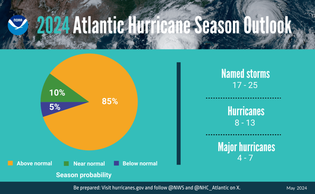 NOAA predicts above-normal 2024 Atlantic hurricane season
La Nina and warmer-than-average ocean temperatures are major drivers of tropical activity
NOAA National Weather Service forecasters at the Climate Prediction Center predict above-normal hurricane activity in the Atlantic basin this year. NOAA’s outlook for the 2024 Atlantic hurricane season, which spans from June 1 to November 30, predicts an 85% chance of an above-normal season, a 10% chance of a near-normal season and a 5% chance of a below-normal season. NOAA is forecasting a range of 17 to 25 total named storms (winds of 39 mph or higher). Of those, 8 to 13 are forecast to become hurricanes (winds of 74 mph or higher), including 4 to 7 major hurricanes (category 3, 4 or 5; with winds of 111 mph or higher). Forecasters have a 70% confidence in these ranges. The upcoming Atlantic hurricane season is expected to have above-normal activity due to a confluence of factors, including near-record warm ocean temperatures in the Atlantic Ocean, development of La Nina conditions in the Pacific, reduced Atlantic trade winds and less wind shear, all of which tend to favor tropical storm formation. “With another active hurricane season approaching, NOAA’s commitment to keeping every American informed with life-saving information is unwavering,” said NOAA Administrator Rick Spinrad, Ph.D. “AI-enabled language translations and a new depiction of inland wind threats in the forecast cone are just two examples of the proactive steps our agency is taking to meet our mission of saving lives and protecting property.” “Severe weather and emergencies can happen at any moment, which is why individuals and communities need to be prepared today,” said FEMA Deputy Administrator Erik A. Hooks. “Already, we are seeing storms move across the country that can bring additional hazards like tornadoes, flooding and hail. Taking a proactive approach to our increasingly challenging climate landscape today can make a difference in how people can recover tomorrow.” As one of the strongest El Ninos ever observed nears its end, NOAA scientists predict a quick transition to La Nina conditions, which are conducive to Atlantic hurricane activity because La Nina tends to lessen wind shear in the tropics. At the same time, abundant oceanic heat content in the tropical Atlantic Ocean and Caribbean Sea creates more energy to fuel storm development. This hurricane season also features the potential for an above-normal west African monsoon, which can produce African easterly waves that seed some of the strongest and longer-lived Atlantic storms. Finally, light trade winds allow hurricanes to grow in strength without the disruption of strong wind shear, and also minimize ocean cooling. Human-caused climate change is warming our ocean globally and in the Atlantic basin, and melting ice on land, leading to sea level rise, which increases the risk of storm surge. Sea level rise represents a clear human influence on the damage potential from a given hurricane. Enhanced communications in store for 2024 season NOAA will implement improvements to its forecast communications, decision support and storm recovery efforts this season. These include:
- The National Hurricane Center (NHC) will expand its offering of Spanish language text products to include all Public Advisories, the Tropical Cyclone Discussion, the Tropical Cyclone Update and Key Messages in the Atlantic basin.
- Beginning on or around August 15, NHC will start to issue an experimental version of the forecast cone graphic that includes a depiction of inland tropical storm and hurricane watches and warnings in effect for the continental U.S. Research indicates that the addition of inland watches and warnings to the cone graphic will help communicate inland hazards during tropical cyclone events without overcomplicating the current version of the graphic.
- This season, the NHC will be able to issue U.S. tropical cyclone watches and warnings with regular or intermediate public advisories. This means that if updates to watches and warnings for storm surge or winds are needed, the NHC will be able to notify the public in an intermediate advisory instead of having to wait for the next full advisory issued every 6 hours.
New tools for hurricane analysis and forecasting this year
- Two new forecast models developed by NOAA researchers will go into operation this season: The Modular Ocean Model or MOM6 will be added to the Hurricane Analysis and Forecast System to improve the representation of the key role the ocean plays in driving hurricane intensity. Another model, SDCON, will predict the probability of tropical cyclone rapid intensification.
- NOAA’s new generation of Flood Inundation Mapping, made possible through President Biden’s Bipartisan Infrastructure Law, will provide information to emergency and water managers to prepare and respond to potential flooding and help local officials better prepare to protect people and infrastructure.
- NOAA’s Weather Prediction Center, in partnership with the NHC, will issue an experimental rainfall graphic for the Caribbean and Central America during the 2024 hurricane season. This graphic provides forecast rainfall totals associated with a tropical cyclone or disturbance for a specified time period.
System upgrades in operation
NOAA will upgrade its observing systems critical in understanding and forecasting hurricanes. These projects will provide more observations of the ocean and atmosphere in the Caribbean, the Gulf of Mexico, on the U.S. East Coast and in the tropical Atlantic.
- NOAA’s National Data Buoy Center recently upgraded many coastal weather buoys in the tropical western Atlantic and Caribbean to include time of occurrence and measurements of one-minute wind speed and direction, 5-second peak wind gust and direction and lowest 1-minute barometric pressure to support tropical cyclone forecasting.
- New this year, NOAA will gather additional observations using Directional Wave Spectra Drifters (DWSDs), deployed from the NOAA P-3 hurricane hunter aircraft and in the vicinity of Saildrones, uncrewed surface vehicles which will be deployed at the start of the hurricane season, providing one-minute data in real time. 11-12 Saildrones are planned for deployment in 2024.
- Starting in June, dozens of observational underwater gliders are planned to deploy in waters off the Caribbean, Gulf of Mexico and the eastern U.S. coast. Additionally, a new lightweight dropsonde called Streamsonde will be deployed into developing tropical storms, collecting multiple real-time observations to collect valuable wind data.
- The CHAOS (Coordinated Hurricane Atmosphere-Ocean Sampling) research experiment aims to improve the understanding of air-sea interactions, providing sustained monitoring of key ocean features.
About NOAA seasonal outlooks
NOAA’s outlook is for overall seasonal activity and is not a landfall forecast. In addition to the Atlantic seasonal outlook, NOAA also issues seasonal hurricane outlooks for the eastern Pacific, central Pacific and western north Pacific hurricane basins. NOAA’s Climate Prediction Center will update the 2024 Atlantic seasonal outlook in early August, prior to the historical peak of the se
Read more » click here
Previously reported – June 2024
This hurricane season could be among the worst in decades, NOAA warns
The NOAA outlook predicts 17 to 25 tropical storms, eight to 13 hurricanes and four to seven “major” hurricanes and is the most aggressive May prediction the agency has made.
The National Oceanic and Atmospheric Administration warned Thursday that the United States could face one of its worst hurricane seasons in two decades as the agency issued its most aggressive outlook ever. Government meteorologists predicted 17 to 25 tropical storms and said eight to 13 of them are likely to become hurricanes, including four to seven “major” hurricanes. The forecast underscores how record-hot ocean temperatures have increased the risk of destructive weather. “This season is looking to be an extraordinary one,” NOAA Administrator Rick Spinrad said. Tropical activity could outpace even a record flurry of storms in 2005, perhaps starting earlier and persisting even longer. That May, warm waters across the tropical Atlantic Ocean prompted warnings of an active hurricane season, but the season exceeded all expectations with a record-smashing 28 storms and seven major hurricanes, including Hurricane Katrina. Now, tropical Atlantic waters are “dramatically” hotter than they were 19 years ago, NOAA’s lead hurricane season forecaster Matthew Rosencrans said — already as warm as they would be in a typical August. And cyclones are intensifying about three times faster than they did decades ago as they approach the coast, according to new research. The trends are largely the consequence of an atmospheric blanket of human-emitted greenhouse gases warming the planet. Evidence of the increasing hurricane risk has mounted with each monster storm that analyses show were juiced by global warming. Adding to storm risks this year is a natural planetary shift known to make conditions more ripe for tropical Atlantic activity, from a fading El Niño climate pattern to La Niña by the heart of hurricane season. A similar shift occurred over the record-setting 2005 hurricane season. The NOAA forecast aligns with several others from meteorologists who see alarming signs in the tropical Atlantic. A forecast issued by Colorado State University last month warned of as many as two dozen tropical storms and as many as five major hurricanes, many of which meteorologists said could be long-lived. Britain’s Met Office on Wednesday predicted 22 tropical storms, with potential for as many as a record-tying 28. Most ominous of all is the forecast from scientists at the University of Pennsylvania, who are calling for a record 33 named storms. Prime storm conditions are expected by fall Tropical systems earn a name from rotating annual lists — this year’s goes from Alberto to William — once they develop rapid rotation around a low-pressure center, with sustained winds of at least 39 mph. They become hurricanes once those winds reach at least 74 mph and are considered major storms when the winds exceed 110 mph. Hurricane season begins June 1, and by the typical heart of the season in August and September, conditions are forecast to be prime for such systems to intensify. Given how warm the Atlantic is this spring — with global ocean surface waters having run a fever of record-setting average heat for more than a year — simple physics suggests it will remain warmer than normal for many months to come. It takes water much longer than land to warm and cool. Across the tropical Atlantic zone in which storms develop, average surface temperatures are running 1 to 2 degrees Celsius (1.8 to 3.6 degrees Fahrenheit) above normal, Rosencrans said. Warmer water means more energy for tropical storms to feed off and unleash. And the expectation of a budding La Niña pattern by late summer or early fall means atmospheric patterns will probably be conducive for storms to organize into tightly spinning systems with defined eyes and violent surrounding winds in what are known as eyewalls. When La Niña is in place, marked by cooler-than-normal waters across the central and eastern Pacific Ocean, atmospheric circulation patterns tend to reduce what is known as wind shear. When wind shear is low, it means there is relatively little difference in wind speeds and directions at varying altitudes, which helps tropical storms spin up and organize. “All the ingredients are definitely in place to have an active season,” National Weather Service Director Ken Graham said. Global warming is encouraging stronger storms The conditions are expected to magnify the background effect that rising global temperatures are having on tropical cyclones in the Atlantic. A growing body of research on storms has shown that they are becoming increasingly intense by many measures, a trend punctuated by a period in which seven major hurricanes hit the United States within six years. Warming is allowing major storms to form significantly earlier during hurricane season, and also encouraging more to undergo rapid intensification more frequently in parts of the Atlantic basin such as the western Caribbean Sea. A study found that a growing number of tropical cyclones around the world have undergone what researchers called “extreme” rapid intensification, with their maximum sustained winds increasing by 57 mph or more within a 24-hour period. Some storms in recent years have so stretched the bounds of the five-step Saffir-Simpson scale of hurricane intensity that two prominent meteorologists recently suggested a Category 6 label could be worth considering. Now, there is evidence that storms are intensifying faster as they near U.S. shores, as well as coastal East Asia, according to a study published this month. The researchers found that coastal storms’ wind speeds intensified by an average of about 0.4 mph every six hours as they approached the coast from 1979 to 2000. But from 2000 to 2020, that happened more than three times quicker, at a rate of 1.3 mph every six hours. Along the U.S. coastline, researchers believe that is because of decreasing wind shear and because of increasing relative humidity as land warms faster than oceans. Karthik Balaguru, a climate and data scientist at the Pacific Northwest National Laboratory and the study’s lead author, said the trends could translate to heightened coastal dangers this year given how favorable the environment is likely to be for tropical storm development. “The ones that form could get strong if these conditions persist,” he said. Even in a quiet season, the most powerful storms can intensify so quickly that communities might have only two days’ warning before a major hurricane hits, Graham said. NOAA and Federal Emergency Management Agency officials urged residents to begin preparing for storms now — considering evacuation routes, medical needs and even pet safety — or else risk being caught off guard or perhaps stuck in heavy traffic on evacuation routes. “You can’t wait until the storm surfaces because then you may not have the time,” Graham said. “You’ve got to be ready.”
Read more » click here
2024 Hurricane Season Is Expected to Be Abnormally Busy, NOAA Predicts
The Atlantic hurricane season is looking to be an extraordinary one, with 17 to 25 named storms predicted, experts said. In yet another dire warning about the coming Atlantic hurricane season, the National Oceanic and Atmospheric Administration on Thursday predicted that this year could see between 17 to 25 named tropical cyclones, the most it has ever forecast in May for the Atlantic Ocean. The NOAA forecast joins more than a dozen other recent projections from experts at universities, private companies and other government agencies that have predicted a likelihood of 14 or more named storms this season; many were calling for well over 20. Rick Spinrad, the NOAA administrator, said at a news conference on Thursday morning that the agency’s forecasters believed eight to 13 of the named storms could become hurricanes, meaning they would include winds of at least 74 miles per hour. Those could include four to seven major hurricanes — Category 3 or higher — with winds of at least 111 m.p.h. According to NOAA, there is an 85 percent chance of an above-normal season and a 10 percent chance of a near-normal season, with a 5 percent chance of a below-normal season. An average Atlantic hurricane season has 14 named storms, including seven hurricanes and three major hurricanes. While it only takes one storm in a below-average season to devastate a community, having conditions conducive to almost twice the average amount of storms makes it more likely that North America will experience a tropical storm or, worse, a major hurricane. There are 21 entries on this year’s official list of storm names, from Alberto to William. If that list is exhausted, the National Weather Service moves on to an alternative list of names, something it’s only had to do twice in its history. NOAA typically issues a May forecast and then an updated forecast in August. Before Thursday, NOAA’s most significant May forecast was in 2010, when it forecast 14 to 23 named storms; that year, 19 ultimately formed before the end of the season. In 2020, the May forecast was for 13 to 19 named storms, but an updated forecast for August was even higher, with 19 to 25 named storms. That season ultimately saw 30 named storms. The hurricane outlooks this year have been notably aggressive because of the unprecedented conditions expected. As forecasters look toward the official start of the season on June 1, they see combined circumstances that have never occurred in records dating to the mid-1800s: record warm water temperatures in the Atlantic and the potential formation of La Niña weather pattern. Brian McNoldy, a researcher at the University of Miami who specializes in hurricane formation, said that without a previous example involving such conditions, forecasters trying to predict the season ahead could only extrapolate from previous outliers. Experts are concerned by warm ocean temperatures. “I think all systems are go for a hyperactive season,” said Phil Klotzbach, an expert in seasonal hurricane forecasts at Colorado State University. The critical area of the Atlantic Ocean where hurricanes form is already abnormally warm just ahead of the start of the season. Benjamin Kirtman, a professor of atmospheric sciences at the University of Miami, earlier described the conditions as “unprecedented,” “alarming” and an “out-of-bounds anomaly.” Over the past century, those temperatures have increased gradually. But last year, with an intensity that unnerved climate scientists, the waters warmed even more rapidly in a region of the Atlantic where most hurricanes form. This region, from West Africa to Central America, is hotter this year than it was before the start of last year’s hurricane season, which produced 20 named storms. The current temperatures in the Atlantic are concerning because they mean the ocean is poised to provide additional fuel to any storm that forms. Even if the surface suddenly cools, the temperatures below the surface, which are also remarkably above average, are expected to reheat the surface temperatures rapidly. These warmer temperatures can give energy to the formation of storms — and help sustain them. Sometimes, if no other atmospheric conditions hinder a storm’s growth, they can intensify more rapidly than usual, jumping hurricane categories in less than a day. Combined with the rapidly subsiding El Niño weather pattern in early May, the temperatures are leading to mounting confidence among forecasting experts that there will be an exceptionally high number of storms this hurricane season. A parting El Niño and a likely La Niña are increasing confidence in the forecasts. El Niño is caused by changing ocean temperatures in the Pacific and affects weather patterns globally. When it is strong, it typically thwarts the development and growth of storms. Last year, the warm ocean temperatures in the Atlantic blunted El Niño’s effect to do that. If El Niño subsides, as forecasters expect, there won’t be much to blunt the season this time. Forecasters specializing in the ebbs and flows of El Niño, including Michelle L’Heureux with the National Weather Service’s Climate Prediction Center, are pretty confident not only that El Niño will subside but that there is a high likelihood — 77 percent — that La Niña will form during the peak of hurricane season. The system could throw a curve ball, she said, but at this point in the spring, things are evolving as forecasters have anticipated. A La Niña weather pattern would already have them looking toward an above-average year. The possibility of a La Niña, combined with record sea surface temperatures this hurricane season, is expected to create a robust environment this year for storms to form and intensify.
Read more » click here
The 2024 NOAA hurricane season forecast is unlike any other. See the record predictions.
Other hurricane outlooks have predicted a dangerous year, thanks to La Niña and record warm Atlantic ocean water. Now NOAA is weighing in.
The start of the 2024 Atlantic hurricane season is just over a week away, and federal forecasters Thursday predicted an “extraordinary” season with as many as 25 named storms possible. This is the most storms the National Oceanic and Atmospheric Administration has ever predicted in a preseason outlook. “All the ingredients are in place for an active season,” said National Weather Service director Ken Graham at a news conference in Washington, D.C. NOAA director Rick Spinrad said the Atlantic hurricane season is shaping up to be “extraordinary,” with an 85% chance for an above-average year. “The forecast … is the highest NOAA has ever issued for the May outlook,” he said at the news conference.
How many hurricanes are predicted in 2024?
Specifically, NOAA is forecasting a range of 17 to 25 total named storms (winds of 39 mph or higher). Of those, 8 to 13 are forecast to become hurricanes (winds of 74 mph or higher), including 4 to 7 major hurricanes (Category 3, 4 or 5; with winds of 111 mph or higher). Previously, the record number of storms predicted in a preseason outlook from NOAA had been “14 to 23 named storms,” back in 2010, according to Erica Grow Cei, a spokesperson for the National Weather Service. The record for most actual named storms in a season is 30, set in 2020. NOAA predicted 13 to 19 named storms that year. A typical year averages about 14 tropical storms, seven of which spin into hurricanes, based on weather records that date from 1991 to 2020. Others predict an active season too Other top forecasters are also predicting an unusually active season. Colorado State University’s hurricane forecasting team, led by Phil Klotzbach, predicted 23 total named storms and 11 hurricanes in its April forecast. That’s the highest number of hurricanes ever predicted in an April forecast by Colorado State since the team began releasing predictions in 1995. Others predicting an active Atlantic season include the UK Met Office and the European Center for Medium-Range Weather Forecasts, which calls for nine hurricanes between April and September, Klotzbach said.
When is the Atlantic hurricane season?
The Atlantic hurricane season officially begins June 1 and runs through Nov. 30. Most storm activity typically happens from mid-August to mid-October. Disturbance spins in the Atlantic Although the official start to the season is still over a week away, a tropical disturbance was reported in the southwestern Atlantic on Thursday, the National Hurricane Center said. The system, which is now just a large area of cloudiness and showers, only has a 10% chance of development and poses no threat to land. “Environmental conditions are not expected to be conducive (for development),” the hurricane center said. “However, some slight tropical or subtropical development is possible while the low moves northeastward through the weekend.”
Why is this season predicted to be bad?
The season is forecast to be unusually active due to a combination of record warm ocean water in the Atlantic and a potential La Niña climate pattern. Warm water gives hurricanes fuel and contributes to a more unstable atmosphere. La Niña − one phase of a cyclical pattern in water temperatures and winds along the equator in the Pacific Ocean − often leads to more active seasons. Eastern Pacific forecast also released Forecasters also released their prediction for the eastern Pacific Basin, saying that a below-average season is likely. An average eastern Pacific hurricane season produces 15 named storms. Eastern Pacific storms and hurricanes primarily stay out to sea and seldom affect the U.S. mainland, although some storms do hit the west coast of Mexico. Last year, eastern Pacific Hurricane Hilary and its remnants wreaked havoc across the U.S. Southwest.
What happened last year in the Atlantic?
In 2023 in the Atlantic basin, there were three major hurricanes that formed among seven hurricanes and 20 named storms, the fourth greatest number of named storms since 1950. The most damaging, Idalia, tore up the west coast of Florida and made landfall as a Category 3 hurricane.
Read more » click here
Hurricane season begins; officials advise detailed planning
In the weeks before this year’s hurricane season began, weather and safety officials worked to spread the same message: Because it only takes one storm to impact a community, prepare now. The National Oceanic and Atmospheric Administration’s National Hurricane Center Director Dr. Michael Brennan said Friday that “we’re on the precipice of what looks to be a very active 2024 hurricane season,” which began Saturday and ends Nov. 30. This is the most active seasonal forecast that NOAA has ever issued in May, with the forecast looking to be busy with 17 to 25 named storms and eight to 13 hurricanes, of which four to seven are expected to become major hurricanes, Brennan said during a press conference at the Miami, Florida-based center. There’s a “very high chance of a very active hurricane season,” but the main message “is preparation has to be the same every year, regardless of what any seasonal forecast says. It only takes one storm affecting you and your community to make it a busy hurricane season,” Brennan continued. Brian Haines with the North Carolina Department of Public Safety told Coastal Review that while the Climate Prediction Center calls for an 85% chance of an above normal season, “history has taught us that it only takes one storm to impact our state, which is why we encourage all North Carolinians to be resilient and prepare for any natural or manmade disaster.” National Weather Service Warning Coordination Meteorologist Erik Heden with the Newport/Morehead City office shared a similar message. “It takes just one storm to make an impact on our life,” Heden said. Assistant State Climatologist Corey Davis, speaking during a recent webinar about this year’s hurricane season forecast, said much the same. “An active hurricane season does not necessarily mean it’ll be an impactful one locally, but by the same token, it only takes one storm in your area to make it a very impactful and a very memorable season,” Davis said.
Tropical storms, hurricanes threats
Heden said Friday to “never, ever focus on just the category of the storm,” referring to the Saffir-Simpson Scale that measures only hurricane wind speeds, which determine a storm’s category, 1-5. “The category tells us only the strength of the storm based on wind alone. It says nothing about how much rain we will see, what the storm surge will be, how long the storm will sit over us, whether or not it is a large or slow-moving storm,” Heden said. Adding, that Irene in 2011 and Florence in 2018 were Category 1 storms. “The category of the storm is part of the puzzle, not the whole puzzle.” Brennan emphasized Friday during the press conference that it doesn’t take a major hurricane making landfall for there to be major impacts. “Rainfall flooding has been the deadliest hazard in tropical storms and hurricanes in the United States over the last 10 years. It’s been responsible for more than half of the fatalities. The rainfall flooding is almost entirely unrelated to the strength of a storm,” Brennan said. “It doesn’t matter what category it is, whether it’s a tropical depression, tropical storm or hurricane, all that matters is how long it rains and how hard it rains in a given location for a given amount of time, and again, that rainfall flooding has been the biggest killer,” Brennan added. It’s water hazards in general have officials most concerned. “The combination of rainfall flooding storm surge and surf and rip currents are responsible for about 85 to 90% of the fatalities we see in tropical storms and hurricanes across the United States,” Brennan said. He called surf and rip currents “an underappreciated hazard” in tropical storms and hurricanes. These have killed more people than storm surge over the last 10 years in the United States, especially along East Coast-facing beaches like Florida, North Carolina and New Jersey. “They’re susceptible to dangerous ocean conditions that are spawned by hurricanes that might be hundreds of miles away.” Post-storm safety is another increasing point of emphasis, Brennan said. “We’ve lost almost as many people after tropical storms and hurricanes in this country in the last 10 years as we’ve lost from the direct forces of the storm itself,” he said. Indirect fatalities are those occurring from accidents, power issues, cardiac arrest, improper generator use, heat exhaustion and lack of medical access that are connected to storms. To help communicate the hazards associated with hurricanes and storms, Brennan said that the National Hurricane Center is disseminating Spanish language products translated by artificial intelligence programs to reach those whose primary language is Spanish. “The other thing we’re doing is rolling out an experimental version of the cone graphic by mid-August that’s going to show the inland extent of the tropical storm and hurricane watches and warnings,” Brennan said.
How, why preparing is critical
Knowing your risk is the first step to prepare for a hurricane, Brennan said Friday. “Know if you live in a storm surge evacuation zone — that forms the foundation of your entire hurricane preparedness plan,” Brennan said. You may be asked to evacuate your home by emergency management or government officials and “you need to know where you’re going to go, how you’re going to get there, what you’re taking with you.” And remember that in many cases, you only need to evacuate tens of miles, not hundreds of miles, to get to a safe place. “Preparation is key. If you’re going to shelter in place for a storm, you want to have your emergency kit in place,” Brennan said, and you should start collecting now multiple days’ worth of nonperishable food, water, medicine, batteries — “anything you’re going to need to survive the aftermath of a major hurricane landfall” — taking into account that there may be power outages for days, with no access to medical or emergency services. Federal Emergency Management Agency Deputy Administrator Erik A. Hooks said Friday during the press conference that officials were “getting down to the wire” when it comes to making sure communities are prepared. “The time to make sure that you have a clear understanding of your unique risk is now,” said Hooks.
Things you should prepare for and take into account to be risk ready include the following:
- Do you have medication that requires refrigeration?
- Do you have a medical device that runs off electricity?
- Do you have mobility challenges that make it more difficult to evacuate in a time?
- When was the last insurance checkup, including flood insurance?
“Now is the time to ask yourselves these questions, understand your particular risk for you and your community, and put a plan together so that you are prepared when disaster strikes,” Hooks said. “Start getting risk-ready now.” Heden said that while peak hurricane season isn’t until Sept. 10, eastern North Carolina has had storms in June and July. “You should prepare each and every year for hurricane season, and please don’t wait,” Heden said. Preparedness is a three-step process, he said. The first step is to know your risk, and “Vulnerability extends beyond weather risk,” Heden said. “Who lives in your home? Do you have young kids, elderly parents? Does somebody in your home rely on power for oxygen? Your vulnerability will help you determine the next two steps.” The second step is to have a hurricane kit with at least three to seven days’ worth of food, water and medicine. If you choose to stay during a storm, you may not be able to get out or first responders may not be able reach you. “Life won’t be normal right away,” and you may be without help for at least three days, or longer, Heden said, also suggesting purchasing items here and there to buffer the financial strain of preparing. And the third step is to have an evacuation plan with at least two places to go, Heden explained. “I like to have a northern and southern option. You want to go away from the storm’s path. Don’t just plan to go to Goldsboro or Raleigh. Sometimes impacts occur well inland,” he said. “Make sure your plan includes your pets and anybody in your house. Your last resort is a shelter. Those are stressful and packed. You will be more comfortable in a hotel or a family or friend’s house.” Haines said to ensure multiple ways to receive information from reputable sources, such as area emergency management team and public safety agencies, local media outlets, or North Carolina Emergency Management. Everyone living or vacationing in North Carolina’s coastal counties should also Know Your Zone. That’s the name of an initiative that established evacuation zones to streamline the evacuation process in the event of an emergency, Haines said. From an insurance perspective, State Department of Insurance Commissioner Mike Causey said Wednesday during a press conference in Kinston livestreamed by Neuse News that preparation should include steps to protect important documents like car titles and deeds. Causey also recommended speaking with an insurance agent in advance of a storm, “and if you don’t have flood insurance, look at getting a flood policy, because you have to have a separate flood insurance policy to have that covered.” Causey cautioned that companies won’t issue insurance when there’s a named storm heading in this direction. “You’re not going to be able to buy insurance, and when you do buy flood insurance, there’s a 30-day waiting period, so you’ve got to think at least more than 30 days ahead to get that flood insurance coverage,” he said. People really need to understand and know that homeowners policies do not cover floods, Causey explained. “We learned that lesson — hard lesson — during Hurricane Florence, when we had 23 southeastern counties underwater, and 88,000 people lost their homes and everything in it and found out they had no insurance because floods are not covered under a homeowner’s policy.” He said the department is there to help and residents can call to speak to a representative or email with questions, disputes or claims. Contact information is on the department’s website.
Why an above-normal forecast?
“Human-caused climate change is warming our ocean globally and in the Atlantic basin, and melting ice on land, leading to sea level rise, which increases the risk of storm surge. Sea level rise represents a clear human influence on the damage potential from a given hurricane,” NOAA officials said when it released the May outlook. NOAA Administrator Dr. Rick Spinrad, speaking during a press conference May 23, said that this season is looking to be extraordinary in a number of ways. Data and models show El Niño/La Niña weather patterns playing a significant role. El Niño is the flow of warm ocean surface waters from the Pacific toward and along the western coast of South America. La Niña is the opposite: an upwelling of cold Pacific Ocean water to the surface along the western coast of South America. “The key this year, as in any year, is to get prepared and stay prepared,” Spinrad said. “It’s the best way to reduce risk, especially the risk of potential loss of life.” The Climate Prediction Center in May forecast a 77% chance of La Niña forming during the August-October time frame and “We know the development of La Nina can lead to weaker easterly trade winds and below average vertical wind shear in the tropical Atlantic Ocean.” Such conditions can be more conducive for tropical cyclone development. Additionally, Spinrad said, NOAA’s National Center for Environmental Information has reported record warm water temperatures for much of the tropical Atlantic Ocean. “Forecast modeling indicates that above-average sea surface temperatures are predicted during the peak months of the Atlantic hurricane season from August to October,” Spinrad said. “We know warm sea surface temperatures are an important factor in rapid intensification of tropical cyclones to major hurricane status.” NOAA’s outlook is for overall seasonal activity and is not a landfall forecast. NOAA’s Climate Prediction Center will update the 2024 Atlantic seasonal outlook in early August before mid-September, the historical peak of the season, officials said. Visit ReadyNC.gov for more information from the state on preparing for storms or knowyourzone.nc.gov to learn more about the coastal evacuation zones.
Read more » click here