
Lou’s Views
News & Views / July Edition
Calendar of Events –
NA
![]() Discover a wide range of things to do in the Brunswick Islands for an experience that goes beyond the beach.
Discover a wide range of things to do in the Brunswick Islands for an experience that goes beyond the beach.
For more information » click here.
Calendar of Events Island –

Concerts on the Coast Series
The Town’s summer concert series calendar has been released! Live performances featuring local musical groups will temporarily be held at the Bridgeview Park picnic pavilion on Sunday evenings from late May to early September. The concerts are free of charge.
For more information » click here
The park will be blocked from vehicular access beginning Saturday evening. The splash pad will be closed on Sundays and the multipurpose court will close at 3:00 p.m. each Sunday. No seating will be provided so everyone should bring their own chair for the event.

Tide Dyed Program
The Tide Dye program will be held on Tuesdays between 1:00 to 2:30 p.m. at Bridgeview Park picnic pavilion. Participants must be in line by 2:00 p.m. to participate because the process takes approximately 30 minutes to complete. Fee is $7 per shirt for youth sizes through Adult XL and $10 per shirt for 2XL. Payment via cash or check only.
.Beginning June 11th and continuing through August 13th
 Turtle Talk
Two programs both are held every Wednesday during the summer at Town Hall. Children’s Turtle Time is at 4:00 p.m. with crafts, stories and activities for children ages 3 – 6. All children must be accompanied by an adult. Turtle Talk is an educational program at 7:00 p.m. for everyone else. (Beginning June 19th)

Summer Day Camp Program
The Town of Holden Beach will hold summer day camps on the following dates:
Thursday, July 18th –
Putterin Around – Join us for putt-putt and ice cream at Fantasy Isle. $12 resident/$17 non-resident; ages 6-12; 10:30 a.m.-noon. Drop off and pick up at Fantasy Isle.
Thursday, July 25th –
Sliding through Summer @ Magic Mountain Waterslide- $25 resident; $30 non-resident; ages 6-12; 10:00 a.m.-noon. Drop off and pick up at waterslide.
Thursday, August 1st –
Fun in Color Art Camp $10 resident/$15 non-resident; ages 6-12; 9:00 a.m.-noon at Town Hall
Thursday, August 15th –
Schools Almost Back Bash at the Splash Pad and Holiday A Polloza – We will briefly revisit holidays celebrated throughout the year with some fun games and end the day with a party at the splash pad. $10 resident/$15 non-resident; ages 6-12; 9:00 a.m. to noon at Town Hall
Register by emailing Christy at christy.ferguson@hbtownhall.com.
 Summer Picnic
To celebrate Parks and Recreation Month, the Town of Holden Beach will offer a summer picnic (indoors) to beat the heat. The event will be held Friday, July 26th at 11:30 a.m. Lunch will be provided. There will also be a dessert bake-off with the theme, “Classic Summer Desserts”. Email Christy at christy.ferguson@hbtownhall.com by July 19th with your name and the number of people in your party if attending the luncheon. Please indicate separately if you plan to participate in the bake-off.
Parks & Recreation / Programs & Events
For more information » click here
Reminders –
 THB Newsletter (03/30/24)
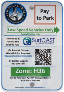
Paid Parking
Paid parking will be enforced starting April 1st in all Holden Beach designated parking areas. It will be enforced from 9:00 a.m. – 5:00 p.m. daily, with free parking before and after that time. All parking will use license plates for verification.
As a reminder, Holden Beach uses the “SurfCAST by Otto” parking solution. Annual passes are now available for purchase on the mobile app. You will also be able to purchase passes by scanning the QR-codes located on the parking signs for access to https://surfcast.ottoconnect.us/pay.
Rates for the 2024 season are as follows:
$5 per hour for up to four hours
$20 per day and for any duration greater than four hours
$80 per week (seven consecutive days)
$175 per calendar year for a single vehicle (annual passes)
Handicap parking is free in designated handicap spaces and only with a valid license plate or hangtag.
Parking rates can be paid via credit card, debit card or PayPal.
Visit https://hbtownhall.com/paid-parking for more information and to view a table with authorized parking areas.

Pets on the Beach Strand
Pets – Chapter 90 / Animals / 90.20
From May 20th through September 10th it is unlawful to have any pet on the beach strand during the hours of 9:00am through 5:00pm.

Solid Waste Pick-Up Schedule
GFL Environmental change in service, trash pickup will be twice a week.Starting the Saturday before Memorial Day through the Saturday after Labor Day: Pick-up is every Tuesday and Saturday from May 25th through September 30th
Please note:
. • Trash carts must be at the street by 6:00 a.m. on the pickup day
. • BAG the trash before putting it in the cart
. • Carts will be rolled back to the front of the house
GFL Refuse Collection Policy
GFL has recently notified all Brunswick County residents that they will no longer accept extra bags of refuse outside of the collection cart. This is not a new policy but is stricter enforcement of an existing policy. While in the past GFL drivers would at times make exceptions and take additional bags of refuse, the tremendous growth in housing within Brunswick County makes this practice cost prohibitive and causes drivers to fall behind schedule.
Solid Waste Pick-up Schedule –
starting the Saturday before Memorial Day (May 25th) twice a week
Recycling –
starting after Memorial Day (June 4th) weekly pick-up
Curbside Recycling – 2024
GFL Environmental is now offering curbside recycling for Town properties that desire to participate in the service. The service cost per cart is $106.88 annually paid in advance to the Town of Holden Beach. The service consists of a ninety-six (96) gallon cart that is emptied every other week during the months of October – May and weekly during the months of June – September.
Curbside Recycling Application » click here
Curbside Recycling Calendar » click here

Trash Can Requirements – Rental Properties
GFL Environmental – trash can requirements
Ordinance 07-13, Section 50.08
Rental properties have specific number of trash cans based on number of bedrooms.
* One extra trash can per every 2 bedrooms
..
§ 50.08 RENTAL HOMES.
(A) Rental homes, as defined in Chapter 157, that are rented as part of the summer rental season, are subject to high numbers of guests, resulting in abnormally large volumes of trash. This type of occupancy use presents a significantly higher impact than homes not used for summer rentals. In interest of public health and sanitation and environmental concerns, all rental home shall have a minimum of one trash can per two bedrooms. Homes with an odd number of bedrooms shall round up (for examples one to two bedrooms – one trash can; three to four bedrooms – two trash cans; five – six bedrooms – three trash cans, and the like).
Building Numbers
Ocean front homes are required to have house numbers visible from the beach strand.
Please call Planning and Inspections Department at 910.842.6080 with any questions.
§157.087 BUILDING NUMBERS.
(A) The correct street number shall be clearly visible from the street on all buildings. Numbers shall be block letters, not script, and of a color clearly in contrast with that of the building and shall be a minimum of six inches in height.
(B) Beach front buildings will also have clearly visible house numbers from the strand side meeting the above criteria on size, contrast, etc. Placement shall be on vertical column supporting deck(s) or deck roof on the primary structure. For buildings with a setback of over 300 feet from the first dune line, a vertical post shall be erected aside the walkway with house numbers affixed. In all cases the numbers must be clearly visible from the strand. Other placements may be acceptable with approval of the Building Inspector.
 Bird Nesting Area
NC Wildlife Commission has posted signs that say – Bird Nesting Area / Please don’t disturb. The signs are posted on the west end beach strand around 1335 OBW.
.
People and dogs are supposed to stay out of the area from April through November
. 1) It’s a Plover nesting area
. 2) Allows migrating birds a place to land and rest without being disturbed

A Second Helping
.
Program to collect food Saturday mornings (8:00am to 10:30am) during the summer at the Beach Mart on the Causeway.
1) Twentieth year of the program
2) Food collections have now exceeded 298,000 pounds
3) Collections will begin on Memorial Day weekend
4) Food is distributed to the needy in Brunswick County
For more information » click here
.
Hunger exists everywhere in this country; join them in the fight to help end hunger in Brunswick County. Cash donations are gratefully accepted. One hundred percent (100%) of these cash donations are used to buy more food. You can be assured that the money will be very well spent.
Mail Donations to:
A Second Helping
% Sharon United Methodist Church
2030 Holden Beach Road
Supply, NC 28462
Storm Events –

Hurricane Vehicle Decals
Property owners will be provided with four (4) decals which were included in their April water bills. It is important that you place your decals in your vehicle or in a safe place. A $10 fee will be assessed to anyone who needs to obtain either additional or replacement decals. Decals will not be issued in the 24-hour period before an anticipated order of evacuation.
The decals are your passes to get back onto the island to check your property in the event that an emergency would necessitate restricting access to the island. Decals must be displayed in the driver side lower left-hand corner of the windshield, where they are not obstructed by any other items. Officials must be able to clearly read the decal from outside the vehicle.
Property owners without a valid decal will not be allowed on the island during restricted access. No other method of identification is accepted in an emergency situation. Click here to visit the Town website to find out more information regarding decals and emergency situations.
EVACUATION, CURFEW & DECALS
What is a State of Emergency?
A proclamation by the Town which enacts special ordinances and/or prohibitions during emergency situations to protect the public, public health and property. These prohibitions can include limitations on movement, curfews, directing of evacuations, controlling ingress and egress to the emergency area, alcoholic beverages, and more. State of Emergencies are issued in accordance with N.C.G.S. 166A-19.22.
What is a curfew?
A curfew is an order, typically during a State of Emergency, which requires all persons in the affected areas to remain on their own property. During a curfew, you are not free to move about public domain areas or on others’ property. Violations of a curfew could lead to arrest in certain situations.
What is a voluntary evacuation?
A voluntary evacuation creates a recommendation for all parties in the affected area to get their affairs in order hastily and evacuated.
What is a mandatory evacuation?
A mandatory evacuation means you must leave the area in which an order has been issued. With recent changes to the laws in North Carolina, you no longer have the option of staying in an area under an order of mandatory evacuation.
Why is the sewer system turned off during a storm/event?
Often the sewer system is turned off during storms which have the potential to create significant flooding on the island. The system is turned off to protect its integrity. If it were left on, it could pose a significant threat to the public health. When the system is manually shut down, it also greatly reduces the time needed to bring it back up after an event which equates to getting residents and guests back on the Island much faster.
Why is there a delay for decal holders to get back on the island once a storm ends?
After a storm, many things must occur before even limited access can be allowed. Some of those things include making sure the streets are passable; the sewer system must be restarted to comply with State laws; the utilities (water, sewer, electricity, propane supplies) must be checked to ensure no safety risk are present; and the post-storm damage assessment team needs to perform an initial assessment.
Where can I get up-to-date information during and after a storm or State of Emergency?
You can sign up for the Town email service by clicking here. The newsletter, along with the Town’s website will be the main sources of information during an emergency situation. Links to the Town’s official Facebook and Twitter pages can be found on the website. You can also download our app for Apple and Android phones by accessing the app store on your smart phone and searching Holden Beach.
Please refrain from calling Town Hall and Police Department phone lines with general information questions. These lines need to remain open for emergencies, storm management and post-storm mitigation. All updates concerning re-entry, general access, etc. may be found on the Town’s website and other media outlets.
Why do I see others moving about the island during a curfew?
If a curfew order is in place, you must stay on your own property. You may see many other vehicles moving about the Island. We often receive assistance from other local, state, federal and contract personnel during events. It is likely these are the personnel you are seeing, and they are involved in the mitigation process for the event. Please do not assume that a curfew order has been lifted and/or you are free to move about the island.
Can I check my friends’ property for them?
If a curfew order is in place, you may ONLY travel to your personally owned property. Traveling about the Island to check on others’ property is not allowed. is in place, you may ONLY travel to your personally owned property. Traveling about
Who can obtain decals?
Only property owners and businesses who service the island can obtain a decal.
How do I get decals for my vehicle…?
If I am an owner?
Decals will be mailed out in water bills to property owners before the season starts. Those owners who need additional decals can contact Town Hall. A fee may apply, please check the current fee schedule.
If I am a renter?
You must contact the owner of the property to obtain a decal.
If I am a business owner on the Island?
You must contact Town Hall to obtain a decal.
If I am a business owner off the Island that provides services on the Island?
You must contact Town Hall for eligibility and to obtain a decal.
When does my decal expire?
All decals expire on the last day of the calendar year as indicated on the decal.
Where do I put my decal on my car?
Decals must be displayed in the lower left-hand corner of the windshield, where they are not obstructed by any other items to include window tinting, other decals, etc. Officials must be able to clearly read the decal from outside the vehicle. Please note that re-entry will not be allowed if a current, intact decal is not affixed to the windshield as designated.
How do I replace a decal if I get a new vehicle?
If you trade a vehicle or otherwise need a replacement decal, you may obtain them from Town Hall during normal business hours. A fee may apply, check the current fee schedule.
Can I obtain a decal right before an emergency occurs?
While most of the storms we deal with are tropical in nature with some type of advanced warning, we do experience many other types of events that could create a State of Emergency without warning. All eligible parties should obtain decals as early as possible each year to avoid being denied access to the Island. Decals shall not be issued during the 24-hour period prior to an anticipated order of evacuation so staff can concentrate on properly preparing the Town for the storm/event.
Can I use a tax bill or another document for re-entry?
No. You MUST have a decal to re-enter the Island until it is open to the general public.
How does re-entry after a storm during a State of Emergency work?
The bridge is closed to all vehicle access, except for official vehicles. Once those with proper decals are allowed access, they must conform with the current rules in place by the specific State of Emergency Order. After all hazards have been rendered safe, the bridge will be opened to the general public. A curfew could remain in effect however, to ensure the safety and security of the Island and its residents and guests. Please understand this process typically takes days to evolve and could be significantly longer, depending on the amount of damage sustained. Please refrain from calling for times for re-entry, as those are often not set on schedule. Instead, stay tunes to local media outlets and official social media accounts for accurate updates.
How can I check on my property if access is limited to the Island?
Once it is safe, property owners with valid decals will be allowed back on the Island after a storm/event. At this point, you can travel to your property, in accordance with the rules of the specific State of Emergency Order currently in place.
If you live out of the area, please do not travel to the Island until you are certain you will be allowed access. Stay tuned to those media outlets and email services that are of official nature for this information. Also, be certain you have your current, valid decal properly affixed to your vehicle.
It is a good idea to be sure your contact information is current with the Town tax office as this is the location Town officials will use in the event you need to be contacted.
For more information » click here
NC General Statute 166A-19.22
Power of municipalities and counties to enact ordinances to deal with states of emergency.
Synopsis – The governing body may impose by declaration or enacted ordinance, prohibitions, and restrictions during a state of emergency. This includes the prohibition and restriction of movements of people in public places, including imposing a curfew; directing or compelling the voluntary or mandatory evacuation of all or part of the population, controlling ingress and egress of an emergency area, and providing for the closure of streets, roads, highways, bridges, public vehicular areas. All prohibitions and restrictions imposed by declaration or ordinance shall take effect immediately upon publication of the declaration unless the declaration sets a later time. The prohibitions and restrictions shall expire when they are terminated by the official or entity that imposed them, or when the state of emergency terminates.
Violation – Any person who violates any provisions of an ordinance or a declaration enacted or declared pursuant to this section shall be guilty of a Class 2 misdemeanor.
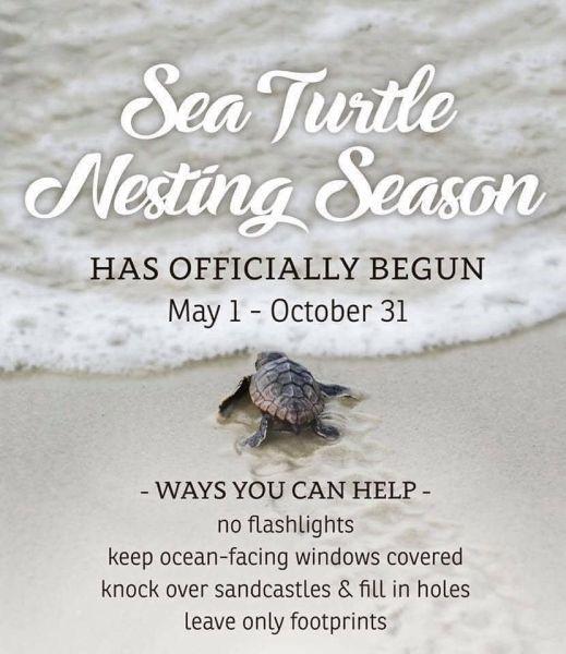
Turtle Watch Program –

Turtle Watch Program – 2024
The first nest of the 2024 season was on May 18th
Average annual number of nests is 57
Current nest count – (59) as of 07/19/24
Members of the patrol started riding the beach every morning on May 1 and will do so through October looking for signs of turtle nests.
For more information » click here
5 things to know about sea turtle nesting season along the NC coast
On May 6, Oak Island had something to celebrate: the Oak Island Sea Turtle Protection Program took to Facebook to announce its first sea turtle nest of the season — also the first nest of the year in North Carolina.
In the coming months, many female sea turtles will follow, making their way onto local beaches to lay their eggs.
Here’s what you need to know about sea turtles.
When do sea turtles come ashore?
Sea turtle nesting season occurs each year from May through September. According to a fact sheet from the North Carolina Wildlife Resources Commission, female sea turtles emerge from the ocean at night, and using their flippers, dig an 18-inch-deep hole that will serve as the nest where she will deposit 80 to 120 eggs. After laying the eggs, she covers the nest and returns to sea.
What happens to the babies?
After about a 60-day incubation period, the hatchlings emerge and make their way to the ocean. Only about one in 1,000 hatchlings will live to reproduce.
Are there different kinds of sea turtles?
Yes. There are seven species of sea turtles worldwide, and five visit the beaches of N.C. According to information from the N.C. Wildlife Resources Commission, the most common in North Carolina is the loggerhead, but one may also see leatherback, green, hawksbill, and Kemp’s ridley.
How can I help sea turtles?
The N.C. Wildlife Resources Commission’s fact sheet lists the following tips:
- Use red filters on flashlights when talking on the beach at night.
- Do not disturb nesting sea turtles.
- Turn off outside lights facing the beach front during sea turtle nesting season.
- Keep dogs on a leash.
- Reduce beach traffic around sea turtle nests.
- Properly dispose of trash.
- Be mindful of sea turtles when boating or using watercraft.
- Volunteer with the Commission, the Karen Beasley Sea Turtle Hospital, or a beach clean-up crew.
- Join a conservation organization.
- Donate to the N.C. Nongame and Endangered Wildlife Fund.
Who do I contact if I see a sea turtle on the beach?
The N.C. Sea Turtle Project works with 20 different volunteer groups. Contact information for each is available at nc-wild.org/seaturtles/contacts, or call the statewide sea turtle hotline at 252-241-7367.
Read more » click here
Upon Further Review –
 Covid summer wave spreads across U.S., even infecting Biden
Coronavirus activity in wastewater reached levels considered “high” or “very high” in 26 states, according to the most recent CDC data.
A summer covid wave has washed over most of the United States, bringing yet another round of gatherings turned into superspreaders, vacations foiled by illness and reminders that pandemic life has not been fully erased. Not even President Biden was spared. Coronavirus activity in wastewater reached levels considered “high” or “very high” in 26 states, according to the most recent data reported by the Centers for Disease Control and Prevention. Other metrics also suggest the virus is rising, including the prevalence of covid diagnoses in emergency rooms and the rate of tests processed at labs coming back positive, but not to the degree of the winter surge. Biden entered isolation in his Rehoboth Beach home in Delaware after testing positive with mild symptoms Wednesday, the most high-profile example of the virus’s reach. In a July 7 campaign event in Pennsylvania, Biden contrasted himself against Donald Trump by declaring, “I ended the pandemic — he didn’t.” His administration no longer treats covid as a public health emergency — instead, managing it as a routine respiratory virus to be blunted with an annual vaccination campaign. This strategy reflects how SARS-CoV-2 has established itself as a common pathogen that no longer overwhelms hospitals or the health-care system — the threat that spurred drastic measures to contain transmission early in the pandemic. “Covid is not gone. Covid is going to be around, probably forever, and we are going to typically see two to three waves a year,” said Ashish Jha, dean of the Brown University School of Public Health who stepped down last year as the White House coronavirus coordinator. “It raises a question of how worried should we be,” Jha added. “It sounds scary, but it’s not, for most people.” At 81, Biden falls into the age group considered at highest risk of developing severe complications from covid. Older adults are more likely to have milder symptoms if they are up to date on their shots and receive antiviral treatment early in their illness, experts say. Biden started a Paxlovid regimen Wednesday and received an updated coronavirus vaccine in September. White House officials did not respond to questions as to whether Biden received a second dose of the latest vaccine as recommended for seniors. The ongoing Republican National Convention in Milwaukee, with an estimated attendance of 50,000, has presented opportunities for covid transmission in an arena crammed with maskless people. (Masks are also uncommon at Biden campaign events.) Phil Griffin, a convention delegate from Winchester, Va., said he brought two masks in case organizers required them, but he has not worried about covid, even after Biden tested positive. “I’ve not heard anybody in Virginia or any of the delegations — Michigan, Ohio, Louisiana — around us that have had any symptoms,” Griffin said. “So, we’re blessed, I guess like the president,” he added, referring to Trump’s narrow escape from a would-be assassin’s bullet. “We’re all at this point blessed to have good health — as far as we know.” Meanwhile, medically vulnerable Americans are navigating another summer fraught with the risk of covid. Elizabeth Kidd watched with trepidation as daily emails from her mother’s assisted-living facility in Northern Virginia started arriving in late June warning of a growing outbreak, including in the memory-care unit where her mother is treated for dementia. Kidd, 52, takes medication that suppresses her immune system to manage her Crohn’s disease, placing her at higher risk for covid. Her mother is 79 and struggles to remember what covid is. So, Kidd did not visit for two weeks, worried the prolonged isolation would make it easier for her mother to forget who she is. “The whole thing is pretty nerve-racking,” Kidd said. “I don’t want covid, and I don’t want to accidentally be the one who brings covid back to the memory unit.” Fortunately, her mother did not get sick, and Kidd visited Tuesday after the facility no longer had active cases but still required masks. As Kidd shared updates with her mother about the grandchildren she doesn’t always remember are her grandchildren, she also reminded her that covid is like a very contagious flu. Covid has spiked every summer since the pandemic started, which experts attribute to increased travel, large gatherings such as weddings and conferences, the rise of new variants and even the heat driving people inside where the virus spreads more easily. “When we’re outdoors, it’s difficult for covid to transmit, but it’s been so oppressively hot, particularly in the southwest United States, and people are just spending a lot more time indoors,” said Andrew Pekosz, professor of microbiology at the Johns Hopkins Bloomberg School of Public Health who specializes in respiratory viruses like covid. The ongoing covid uptick coincides with the ascendancies of KP variants dubbed FLiRT and the closely related LB. 1, which accounted for 85 percent of new cases as of early July, according to CDC estimates. They have mutations that make it easier for the virus to spread than previous variants and to more efficiently infect people who have some level of immunity. But they do not appear to cause more serious disease. WastewaterSCAN, a private initiative that tracks municipal wastewater data, found a 54 percent increase in copies of viral RNA per gram of wastewater solids between June 30 and July 12. Viral levels were high in most regions and medium in the Midwest. “You might have some summer travel plans that you don’t want to have ruined or affected by you being sick,” said Alexandria Boehm, an environmental engineering professor at Stanford University and principal investigator of WastewaterSCAN. “If you are immunocompromised, this might be a good time to think about masking or just to be cautious about going into crowded venues.” Demetre Daskalakis, director of the CDC’s National Center for Immunization and Respiratory Diseases, said increases of the virus in wastewater should not be viewed in isolation, and officials are not seeing significant upticks in severe outcomes such as hospitalizations and deaths. While covid does not hospitalize and kill people as often as it used to, even mild cases can still be disruptive and inflict illness that can feel nastier than the patient would expect. Jay Brodbar, who hasn’t taken a flight since the start of the pandemic, regularly masks indoors and received his latest coronavirus vaccine in April, had hoped he’d continue avoiding the virus as he embarked on a two-week road trip through the Northeast. But the 74-year-old started experiencing fever and chills on July 8 while he was in New York and tested positive the next day. Brodbar cut his trip short by a week and drove eight hours back home to Toronto. Reeling from what he described as the worst sore throat of his life, he said he felt better after taking Paxlovid and a steroid nasal spray. Summer covid waves come at an awkward time for public health officials who have made fall vaccination campaigns the cornerstone of their response. The current vaccine targets the defunct XBB variants. Updated vaccines won’t hit the market for at least another month, leaving patients and their providers to discuss the trade-offs of getting an outdated shot now that still offers some protection or waiting for the new version. Reinfections pose continuing health dangers, particularly to those in high-risk groups. A severe covid case increases the odds that a person will land in the hospital with covid again, according to a study published earlier this month in Communications Medicine. Lingering symptoms known as long covid, which can even follow mild cases, remain one of the most confounding consequences of the virus. Long covid has become less common as hospitalizations decline, but research shows severe disease is a primary risk factor. While public health officials tout that Americans now have the tools to combat covid, those tools are getting tougher to access. The federal government has stopped widespread distribution of free masks and test kits. The federal Bridge Access Program to offer free coronavirus vaccines to uninsured people ends in August. Health officials are imploring people at higher risk for developing severe covid to test when symptomatic and take Paxlovid early to stop viral replication, as Biden is doing. But other Americans are having a harder time than the president getting Paxlovid. Many pharmacies do not have the medication stocked given the previous low demand. And those who do manage to access the medication are sometimes hit with eye-popping bills. Robyn DeChabert, 27, received a prescription for Paxlovid when the Virginia Beach resident went to an emergency department Sunday with difficulty breathing and a painful cough. She credited the antiviral treatment with hastening her recovery the last two times she contracted covid, when she received the medication free because the federal government had covered the costs. But when her sister went to pick up the prescription for her this time, the pharmacy charged $1,700, which she could not afford. Her sister left without the medication. DeChabert is uninsured until she starts her service industry job next month. “It is still baffling to me that a medicine that two years ago was very much accessible to a lot of people is now something that’s being priced out for many Americans,” said DeChabert, who was able to get Paxlovid from a friend. “I shouldn’t have to go into medical debt just to be able to live.” Pfizer, the manufacturer of Paxlovid, offers some patient assistance programs to cover out-of-pocket costs for people who have no health insurance or who are on government insurance plans, as well as up to $1,500 in co-pay assistance for people with commercial insurance. Kit Longley, a Pfizer spokesperson, said enrollment in both programs takes minutes to complete to access electronic vouchers. But some providers and pharmacies do not tell patients, and DeChabert said she was never informed assistance was available.
Read more » click here
Biden just got covid. What are the latest coronavirus guidelines?
President Biden’s positive coronavirus diagnosis places a spotlight on precautions the public, especially older Americans, can take amid a summer covid wave.
President Biden tested positive for the coronavirus Wednesday, placing a renewed spotlight on covid-19 and the precautions the broader public can take as a summer wave of the disease sweeps over much of the United States. In a statement, the White House said Biden is experiencing mild symptoms and plans to self-isolate at his home in Rehoboth Beach, Del., while continuing to work. The president, who previously tested positive for the coronavirus in 2022, told reporters he was “doing well” after landing at Dover Air Force Base late Wednesday. Coronavirus levels in wastewater were considered high or very high in 26 states, the Centers for Disease Control and Prevention reported last week, but the nation’s approach to the pandemic has evolved significantly over the years — meaning it can be difficult to determine how best to stay safe. Here’s what to know.
What are the current CDC isolation guidelines?
When sick with symptoms of a respiratory virus, such as the coronavirus, the CDC advises individuals to stay home and isolate until both their overall symptoms have improved and they have been fever-free without using fever-reducing medication for 24 hours. For five days after that, it recommends taking extra precautions such as wearing a mask, improving air circulation, physical distancing and testing. The CDC also recommends taking these precautions if covid is circulating widely in the community. People who are asymptomatic do not need to stay home but should take those extra precautions, said Demetre Daskalakis, director of the CDC’s National Center for Immunization and Respiratory Diseases. If people do not have a fever, they should still isolate until their overall symptoms have improved for 24 hours, he said.
What if someone in the house has covid but others do not?
The stay-at-home guidance gets trickier when there are others in a household. In that case, Daskalakis advises people with coronavirus to keep their distance from other adults if possible and to use additional precautions, such as masking or improving air circulation.
What are the latest vaccines?
The currents coronavirus vaccines were developed with a formula targeting the defunct XBB variants but still offer some protection against the latest variants. An updated vaccine is expected in the late summer or fall. Staying up to date with coronavirus vaccines “significantly lowers the risk of getting very sick, being hospitalized, or dying from covid-19,” the CDC says. The CDC recommends adults 65 and older get a second dose of the current coronavirus vaccine, and everyone ages six months and older get the updated vaccine when it is available. Experts say patients who have not recently been infected or vaccinated should consult their doctors about the trade-offs of getting an outdated shot for protection amid the summer covid wave or waiting for the new version expected to be available in the coming months.
What specific advice do health-care professionals have for senior citizens?
While doctors are seeing far fewer hospitalizations for covid, “older individuals remain at the highest risk” and “still can get quite ill,” Tara Vijayan, an infectious diseases specialist at UCLA Health, wrote in an email, noting that taking antivirals early and getting vaccinated can mitigate that risk. If an older adult tests positive, Vijayan recommends considering taking Paxlovid, which President Biden took Wednesday, or molnupiravir, which may have similar benefits. Doctors are divided on whether younger, otherwise healthy adults should take Paxlovid. If people are charged for Paxlovid, which is no longer free, they can apply for support from patient assistance programs to cover out-of-pocket costs, or ask a provider or pharmacist to help. For older adults looking to protect themselves, Vijayan said it is reasonable to consider masking indoors, especially in crowded or poorly ventilated spaces. She emphasized, however, that close family members are “by far the most common source” of infection. Vijayan encourages relatives of older adults to take a test if they have signs of an upper respiratory tract infection and stay away from older family members until they are no longer contagious.
What are the current coronavirus variants and how prevalent are they?
These days, most cases are caused by new KP variants, which are part of a group called FLiRT, and LB.1. They are more effective than their predecessors at infecting people who have some immunity from vaccines or previous infections. The new variants do not seem to cause more severe infections and deaths. The new vaccines under development target the KP.2 strain, which is similar to the other commonly circulating variants. Preeti Malani, an infectious-diseases physician at the University of Michigan, told The Washington Post earlier this month that the “clinical difference is minor, if any.”
Read more » click here
 ‘It’s out of control’: OKI to explore limiting house sizes per council directive
The town council put forth a proposal to limit house sizes in Oak Island on Tuesday and the measure now heads to the town’s planning board for review. Council member Bill Ciullo proposed two scenarios in which the town could limit mega-home construction aimed at reducing an influx of rental houses instead of residences. Cuillo brought forth this idea at a meeting two weeks ago and the discussion was continued to Tuesday’s meeting. “Oak Island residents and homeowners have asked us to limit house size and maintain the small town feel of our community,” Ciullo said. “It was stated loud and clear in our comprehensive land use plan, as well as on election night.” Ciullo proposed two options; one would be to lower square footage on homes constructed to 3,500 square feet and eliminate residents’ ability to apply for special use permits to exceed that amount. The council member described this as a “simple, one-size-fits-all approach” that would apply to all single-family homes regardless of lot size. The second approach would be to limit home size as proportionate to lot size. The example put forth by Ciullo would limit homes on 6,600-square-foot lots to 2,970 square feet, while the allowance would cap at 4,000 square feet with no special-permit exception. Ciullo said the proportionate option would require town staff to examine their size-based zoning metrics for loopholes and complications — “crossing our Ts and dotting our Is,” he said. Council member Mark Martin said he was concerned about this approach, as the town already has land development rules based on lot size. The adopted rule would be applicable to all new construction across the island and in the R7 zoning district of the town’s mainland. The board member claimed that if the town did nothing, developers would continue to gobble up lots for 3,995-square-foot homes and incongruently build them next to smaller homes in the 1,000 to 2,000-square-foot range — this would be the first wave, he said. The second wave would be demonstrated by developers acquiring and demolishing those smaller beach bungalow properties to make way for their 15-bedroom complexes. “While many of the cows have left the barn, we still have plenty of cows left in the barn, which we can save,” Ciullo said. The council member requested the planning board be asked to review each option — and no alternative — to provide a recommendation to council; the motion was seconded by council member Terri Cartner. Council member Bill Craft said he and Ciullo were in harmony with their desire to eliminate special-use allowances for large homes, but he thought Ciullo’s warnings were overblown. He said every town he talked to, including Carolina Beach and Holden Beach, do not limit square footage and instead rely on impervious surface and setback regulations to limit development size. Craft said CAMA guidelines allow Oak Island beach houses to reach 5,000 feet, but noted very few would ever reach that size because the average lot size is 0.12 acres — homeowners would need two lots to reach an allowable 4,000-square-feet. The council member also addressed claims that Oak Island would become like Myrtle Beach, South Carolina, if action were not taken; that claim is common among coastal communities when faced with land development decisions. “That’s a scare tactic,” Craft said. He stated Oak Island maximum building height is 41 feet, while buildings in Myrtle Beach well exceed that. Craft suggested the town maintain its 3,995-square-feet limit and enforce it by eliminating special-use permits, as increasing the gap between the town’s allowance and CAMA guidelines would put the town at risk of a lawsuit. This is not the first time the issue of short-term rentals or house size has crossed the Oak Island dais. Both Craft and council member John Bach have voted to restrict house sizes in the past. “What both of you have illustrated is what people say to me — it’s out of control,” Bach said. “And I’m forced to say, ‘Yeah, but it’s legal.’” He said he supported the planning board’s exploration of Ciullo’s two options. Martin said he was wary of targeting full-time investment rental properties. “Why would I deter my neighbor’s ability to rent their home if they’re in financial need?” Martin said. Martin said he was in favor of special use permits as it allowed council to place conditions on the property they otherwise would not be able to; Ciullo disputed this, saying the permits have been used against them and improvements are made with commercial properties, not residential. Martin was also against the limitations put on the planning board, suggesting the body be allowed to explore and recommend business as usual and the 5,000-square-foot ceiling. Ciullo said free-ranging discussion could last until Christmas. “There’s expectations around people that own property; they see what’s being built, they see design, they understand what’s possible,” Martin said. “They’ve been sitting on these parcels, and now it’s time for them to make their dream come true.” Bach asked that council further debate the issue when the planning board submitted their determination, which could be that neither option was satisfactory, though alternative solutions are not being solicited. The vote to send the issue to the planning board passed 4-1, Martin dissenting. The planning board has until Aug. 26 to return a recommendation.
Read more » click here
Corrections & Amplifications –
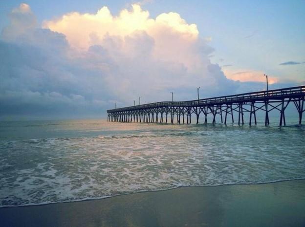 What to know as plans to restore this BC fishing pier inch forward
Evening walks on the pier and afternoon fishing trips are classic parts of any beach trip. This year, however, marks the second summer in a row that Holden Beach visitors and residents have missed out on those memories. The Holden Beach Fishing Pier has been closed to the public since 2022, after the town purchased the pier and pier house property for around $3.3 million – without plans in place for its future. The Holden Beach Board of Commissioners got to work assessing the pier’s existing structural issues and forming a conceptual plan to renovate the property. After approving a final site plan for the property in February 2023, new board members were elected in November 2023. In December, the board was set to act on bids received for the renovation project. Instead, the board paused the project to allow the new board members to get caught up on its status and scope.
Here’s where things stand now.
Project slowly moving forward again
Earlier this year, a public input session was held to allow the public to review plans for the pier and offer their thoughts. Following that meeting, the town’s board of commissioners is inching forward with the project once again. In April, the board approved a pier property development plan to serve as a “baseline approach” and “starting point” for the development. That plan notes the repairs to the existing structure will likely need to occur in phases as funding is available. The plan suggests those phases would be to stabilize the existing structure, complete safety repairs, complete remaining repairs and extend the pier, in that order. The adopted plan also notes that, due to cost, the pier would likely be replaced with a new wood pier, rather than a concrete pier. “Although a concrete pier is preferred, it may not be financially supportable for a small tax base like Holden Beach,” the document states. Additionally, the plan notes that funding for a pier replacement would likely require financing through a loan or bond.
What’s next?
In May, the board voted to direct staff to develop a request for proposals (RFP) to move forward with accomplishing the first few tasks outlined in the pier property development plan: Preliminary design and receiving cost estimates for the repair or replacement of the pier.
Read more » click here
 Flood history questions added to real estate disclosure form
Sometimes it’s a puzzle why people don’t ask more questions, such as, “Has the river that’s down your road ever flooded your house, the house I’m thinking of buying?” The maxim “buyer beware” is wise advice no matter where a house is situated, but it’s good to have rules in place to cover homebuyers’ backs for the things they overlook or wrongly assume. As of July 1, prospective real estate buyers in North Carolina must now be provided the required North Carolina Real Estate Commission residential disclosure form by the seller that for the first time includes questions related to a property’s flood risk. The change in the form was requested in a petition for rulemaking filed by the Southern Environmental Law Center in December 2022 on behalf of the Natural Resources Defense Council, or NRDC, the North Carolina Justice Center, MDC Inc., the North Carolina Disaster Recovery and Resiliency School, Robeson County Church and Community Center, and NC Field. “Most of those are small, local nonprofits that respond to disasters,” Brooks Rainey Pearson, senior attorney with the law center, told Coastal Review in an interview, referring to petitioners. “So, we really wanted to give a voice to the people on the ground who deal with the fallout from flooding.” Pearson said that the Real Estate Commission had quickly granted the petition at the time and agreed to add the questions proposed by petitioners. It was then delayed by mutual agreement, she said, to adjust the law to allow the commission to merely make changes in the form. That would avoid having to go through a lengthy rulemaking process. “It was a longer journey than it should have been, but not because of any pushback,” she said. “I think everyone understands that homebuyers deserve to know if the property has flooded before.” Questions about flooding that have been added to the disclosure statement include the following: Is the property located in a federal or other designated flood hazard zone? Has the property experienced damage due to flooding, water seepage or pooled water attributable to a natural event such as heavy rainfall, coastal storm surge, tidal inundation, or river overflow? Is there a current flood insurance policy covering the property? Is there a flood or Federal Emergency Management Agency elevation certificate for the property? Has (the property owner) ever filed a claim for flood damage to the property with any insurance provider, including the National Flood Insurance Program? The form also notes that the requirement to obtain flood insurance passes down to all future owners for those properties that have received disaster assistance. Joel Scata, senior attorney with the NRDC, a national environmental nonprofit organization that is one of the petitioners, said that in the past, the only flood information that had to be disclosed to homebuyers in North Carolina was whether the property was in a floodplain. “Now with the changes, a buyer is going to have access to much more detailed information,” he told Coastal Review. According to state law, residential property owners are required to complete the disclosure statement and provide it to a buyer before an offer is made to purchase the property. New construction or never-occupied properties are exempted. Every question must be answered with “Y,” “N,” “NR” or “NA” for “Yes,” “No,” “No Representation,” and “Not Applicable,” respectively. Despite stern language in the form about requirements, there is enough gray area to give pause to anyone with insight into human failings. “An owner is not required to disclose any of the material facts that have a NR option, even if they have knowledge of them,” the statement says. Also: “If an owner selects NR, it could mean that the owner (1) has knowledge of an issue and chooses not to disclose it; or (2) simply does not know.” The form does warn that failure to disclose hidden defects “may” result in civil liability. It also assures that if an owner selects “No,” it means that the owner is not aware of any problem. But if “the owner knows there is a problem or that the owner’s answer is not correct, the owner may be liable for making an intentional misstatement.” If an owner selects NA, it means the property does not contain that particular item or feature. Scata said that he believes that whatever remedies are available for enforcement are strictly civil, and do not include criminal charges in the case of fraud or misrepresentation. “A buyer could file a civil suit, claim that the seller intentionally misled the buyer, make a fraud claim,” he said. But damages and other penalties would depend on the impact of what wasn’t disclosed, he added. A buyer should take any “NR” answer as a cue to ask the owner about what they don’t want to disclose, Scata said, adding “it’s a good indication that something is wrong with the property.” That choice could not be removed from the form unless it was done through a change in the legislation, he said. “The buyer always has the right to go back and explicitly ask the seller the question,” he said. And don’t just push the question with the buyer, he said, but also go talk to neighbors about the situation with flooding episodes in the neighborhood. Also, real estate brokers by law have a duty to disclose what they know, or reasonably should know, regardless of the seller’s response. “So, if a seller says something like ‘No, there’s never been (flooding) on the property,’” Scata said, “but the Realtor knows that’s not true, there’s a duty on them to disclose. And they can be liable if they are complicit in that fraud.” In that instance of potential fraud by a broker, the buyer can file a complaint with the Real Estate Commission. According to an NRDC press release, homes in North Carolina with prior flood losses would be expected to average an annual loss of $1,211, compared to $61 for the average home. In 2021, there were 13,237 homes purchased that were estimated to have been previously flooded. The expected annual flood damage totals for those homes were estimated at about $16 million. With climate change causing more intense rain and stronger storms, flooding is only going to become more of an issue, Pearson said. “Before when you only had to disclose if the house was in a floodplain, well, that’s no longer a good indicator of whether your house might flood,” she said. “The best indicator of whether your house might flood is whether it’s flooded before. And so, we think, just for the sake of transparency, people deserve to know that. But they also deserve to know that because — I believe it’s called behavioral economics — when people have more information, they’ll make different and better decisions.”
Read more » click here
Odds & Ends –
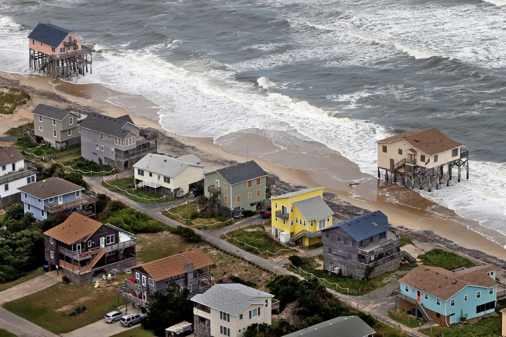
We Need to Decide Which Beaches to Save — and Which Ones to Abandon
Last December a surprise storm passed through Florida’s Pinellas County, ripping away beaches and wiping out half of the sand dunes from St. Petersburg to Clearwater. The damage was extensive, and all the more painful because the county had just spent about $26 million hauling in sand to build up the dunes after a hurricane had pummeled them in August. But this turn of events is far from unusual. Beach communities around the world are spending staggering sums replacing sand as big storms and rising seas wash it away. What used to be a maintenance task every 10 years or so is now often an annual event. For many communities, engineering the beach is worth the hefty price tag to protect properties and tourism. But as climate change hastens beach erosion, trucking or shipping huge quantities of sand to replenish beaches is likely to become economically untenable and logistically impractical. Policymakers may soon have to make painful decisions about which shores and structures to save. This doesn’t necessarily spell disaster for beach lovers. Beaches were intended to move around, and they’re better off when they do. Unlike other effects of climate change that look bleaker the further into the future you look, migrating beaches could ultimately make America’s coasts healthier by providing coral reefs and wildlife affected by sand replenishment with the habitats they need to thrive. Beachfront communities have had to maintain the sand on their shorelines ever since beaches became the holiday ideal in the early 20th century. By the mid-1930s waterfront construction in Coney Island, N.Y., Waikiki, Hawaii, and Atlantic City, N.J., had eroded beaches so much that they all had received their first infusions of sand. The federal government became more involved in the effort in the middle of the 20th century, when protecting American shores from natural disaster became part of the mandate of the Army Corps of Engineers. The agency typically picks up more than half the tab for local beach replenishment projects, while the Federal Emergency Management Agency often steps in when beaches are destroyed by hurricanes. Now more than ever, beach communities rely on this support to keep attracting the tourists who patronize beachfront resorts, vacation homes and rental properties. In the United States alone, beach tourists generate $36 billion in taxes annually. So, it makes sense that the government spent an estimated $8.2 billion on beach replenishment this century alone, compared to just over $3.6 billion over the entire 20th century. Beaches will only require more nourishment as worsening storms wash them away, sea level rise makes it harder to keep sand in place, excessive groundwater extraction causes land to sink and the rivers that once deposited sand on the coast dry up. Already beaches near San Diego and San Clemente, Calif., are shrinking by an average of 4.75 feet per year. Without them, nothing separates the fury of the ocean from the homes, resorts and other buildings that dot the shore. Even finding sand has grown more difficult; many offshore reserves are already depleted, forcing dredging vessels to venture further offshore to find sand and dig it up from the ocean floor. In some places sand has to be transported by the truckload from inland at considerable extra cost — or even purchased from other countries. The Jewel Grande resort in Montego Bay, Jamaica, for example, imported sand all the way from the Bahamas to build up its beach before it opened for business in 2017. Beach towns are already competing with companies that use sand to manufacture not only concrete, glass, and asphalt but also cellphones, semiconductors, and microchips. Global demand for sand tripled in the first two decades of this millennium. Resulting competition has led to so-called sand mafias mining it illegally in many countries, from Morocco to Indonesia, and pushing up the price around the world. For many U.S. communities whose economies depend on beach tourism, spending tax dollars on beach replenishment may be worth it for now, but the economics are becoming less favorable every year. In Southern California the amount of sand required to replenish beaches is likely to triple by 2050, and the cost could quintuple, according to a recent study. Many swaths of the Jersey Shore already require replenishment every year or two, and if the sea there rises more than a foot over the next 30 years, as the National Oceanic and Atmospheric Administration has predicted, the need will only grow. Soon there will be no way to keep up. Some coastal communities will eventually stop rebuilding their beaches, either abruptly or through what’s known as managed retreat, a coordinated, gradual move away from the shore that avoids shocks to property owners and residents. In these cases, the funds currently being siphoned off to shore up beaches could be redirected to more temporary buildings like modular homes or tents that can be relocated easily. The funds could also go toward government programs that buy back property, especially from homeowners, who may relocate or rent their homes from the government while it remains feasible. Managed retreat discourages new development, as opposed to beach replenishment, which encourages it. Of course, beaches will disappear. But they may pop up elsewhere, and this is how today’s beach erosion could benefit shorelines tomorrow. While nourishment is rooted in our insistence that beaches stay in one place, in truth, beaches were never the constants we imagine them to be. Left to their own devices, they would simply shift, even as sea levels rise. Some would drift down or up the shore, or shrink and then widen again as the power of wind, waves and tides guide sand in different directions. Others would move inland. The lucky ones would actually expand. This kind of migration is natural, and even ecologically healthy, allowing beaches to support the birds, fish and coral reefs that depend on them. In some places, this is already happening. Just south of Los Angeles, Huntington Beach is getting wider every year. In the Netherlands, Schiermonnikoog Island easily handles 300,000 visitors per year while its beach continually widens. Undeveloped barrier islands off the coast of Georgia are holding up just fine, as they are allowed to ebb, flow, and adapt to changing natural conditions. Researchers who studied 184 relatively untouched islands in the Maldives found that while 42 percent were eroding, 39 percent were relatively stable and 20 percent were growing. We can’t predict how any given beach will behave when left alone, and we don’t know exactly what shape new shorelines will take. But ending nourishment does not mean saying goodbye to enjoying a day in the sand. If we get out of the way, beaches will endure.
Read more » click here
 Want to fish at the NC coast? Then you need a license.
Whether you’re a tourist or a local angler, you need a license to fish at the N.C. coast. Here’s why, and how to get one.
If you’re headed to the beach or plan on hitting the water this summer, there are some things you are certainly going to pack. Sunscreen to protect you from the scorching Carolina sun, more than likely a few beverages to keep you hydrated, and maybe some beach toys and a Shibumi Shade are all likely coming along. But if you plan on casting into the surf or testing your luck in the state’s offshore or inland coastal waters, there’s one more thing you need: a fishing license. Whether you are a tourist from Tennessee, an avid angler from Asheville, or a local lad from Leland, recreational fishermen of all skill levels over the age of 16 have been required to have a valid N.C. Coastal Recreational Fishing License since 2007. The idea isn’t to discourage fishing, but the exact opposite. “We want to help protect and maintain this natural resource that we all enjoy for our generation and for future generations,” said Capt. Garland Yopp with the N.C. Marine Patrol. Proceeds from license sales are used by the N.C. Division of Marine Fisheries (DMF) and state Wildlife Resources Commission (WRC), which manages North Carolina’s freshwater public waters and shares management of some inner coastal areas with DMF, to manage, protect and conserve the state’s marine resources − from making sure fishing stocks aren’t falling too low to maintaining and expanding public boat launch sites. And with fishing, like many other outdoor activities, exploding in popularity since the COVID-19 pandemic, coupled with the tremendous growth all of the N.C. coast has seen in recent decades, that’s becoming a bigger challenge every year, said Yopp, who oversees the state’s southern coastal areas.
Who needs a N.C. fishing license?
Basically, anyone over 16 who intends to fish. A coastal fishing license is required even if you’re just planning to do some catch-and-release fishing, not catching something for personal consumption. Yopp said that includes fishing offshore, since boaters will have to traverse state waters − which extend 3 miles offshore − when traveling to and from their offshore fishing grounds. Commercial piers, however, have a blanket license that covers recreational fishermen, so individuals don’t need their own license to fish from them. Folks also can fish license-free anywhere along the coast on July 4.
How do I get a license?
Government isn’t generally known as an entity that makes it easy to get the necessary permit or paperwork to do something. But that’s not the case when it comes to fishing licenses. Yopp said probably the easiest way to get a license is through the WRC’s online portal. Once you’ve selected and paid for your license, you will receive a digital copy of your license that you can keep on your cellphone or print out for a hard copy. Fishing licenses also can be purchased at most big box retailers, like Walmart, sporting good shops, some hardware stores, and at local DMF and WRC offices.
Are there different types of licenses?
Yes, so a tourist visiting Brunswick County for a week doesn’t have to buy a year-long license that a beach house owner from the Triangle might want. A short, 10-day coastal fishing license is $6 for a N.C. resident and $11 for a nonresident. Annual licenses are good for one calendar year from when they are issued. For state residents, a 1-year license costs $16. It is $32 for a nonresident. Since a separate fishing license is required to fish in the state’s freshwater lakes, rivers and streams, fishermen also have the option of buying a unified license. North Carolina also offers lifetime licenses and discounted licenses for certain groups, like disabled veterans. Information on the types of fishing licenses and their cost can be found at www.eregulations.com/northcarolina/fishing/fishing-licenses.
What if I cast without a license?
Yopp said officers have the option of issuing a verbal warning or charging someone with a misdemeanor, which carries a fine that can range from $35 on up and could see future fishing privileges suspended, depending on the situation. He said most fishermen understand and want to follow the rules, and many of the issues law enforcement comes across have to do with licenses that have expired. “We still do see some violations, because like anything you always have some bad apples,” Yopp said. “But as a general rule we have pretty good compliance.” He added that just because you are a weekend angler or a tourist doesn’t mean you aren’t responsible for knowing N.C.’s fishing rules, and that includes what you can catch and keep. “If you don’t know how to ID a fish or what size is legal, then you probably shouldn’t have it in your ice chest,” Yopp said, adding that there are plenty of online information on the DMF’s website and via smartphone apps like FishRules to help keep fishermen informed. “I really think most fishermen want to do the right thing, and most of them do.”
Read more » click here
This and That –

This Brunswick town has the best beach in NC, according to a USA TODAY poll
Southeastern North Carolina towns dominated a USA TODAY 10Best reader poll ranking the state’s best beaches. On Tuesday, USA TODAY announced the results for its Best Beach in North Carolina poll, as well as best beaches in six other states. Candidates for 10Best lists are chosen by expert panels and voted on by readers to determine the final top 10 for each list. Of the 10 beaches recognized on the Best Beach in North Carolina poll, area beaches occupied eight spots. Ocean Isle Beach was named the best beach in the state, with all three New Hanover County beaches following — Carolina Beach in second place, followed by Kure Beach and Wrightsville Beach. Oak Island and Holden Beach, both Brunswick County beaches alongside Ocean Isle, took the fifth and sixth rankings. Pender County’s Topsail Beach and Surf City were placed ninth and 10th.The only beaches recognized that were not located in the Wilmington area were Atlantic Beach and Kill Devil Hills.
Here’s the top 10:
- Ocean Isle Beach
- Carolina Beach
- Kure Beach
- Wrightsville Beach
- Oak Island
- Holden Beach
- Atlantic Beach
- Kill Devil Hills
- Topsail Beach
- Surf City
Read more » click here

Trends report: Wilmington first among most moved-to cities
What states and cities are becoming popular moving destinations? PODS Enterprises LLC, released its fourth annual Moving Trends Report identifying the top 20 cities Americans are fleeing from, and flocking to, in 2024. The report analyzes consumer movements throughout the past 15 months, identifying the environmental and economic factors that inspired these trends. Wilmington, for the second consecutive year, landed the top spot on the move-in list. The area was tied in with nearby Myrtle Beach, South Carolina. “Last year, we noted the Carolinas were worth watching, and this year, they’ve not only taken the trophy as the number one spot for new moves but also broken a record,” said Rich Schwartz, SVP of Corporate Operations at PODS. More Americans are calling the Southeast home with the promise of lower costs of living, an exceptional quality of life, the food scene, easy access to nature, and vibrant metro areas. Wilmington is well known for its 1.75-mile-long Riverwalk, seafood restaurants, markets, art galleries, narrated history tours and boat tours. Other attractions are the Battleship North Carolina and the Cotton Exchange, a shopping complex consisting of historical buildings dating back to the late 19th and early 20th centuries, located in downtown Wilmington.
The top 10 cities with the highest number of move-ins:
- Myrtle Beach, South Carolina / Wilmington (1stin 2023)
- Ocala, Florida (4thin 2023)
- Houston (5thin 2023)
- Greenville-Spartanburg, South Carolina (10thin 2023)
- Charlotte (16thin 2023)
- Raleigh (20thin 2023)
- Phoenix (18thin 2023)
- Knoxville (7thin 2023)
- Jacksonville, Florida (8thin 2023)
- Asheville (17thin 2023)
Read more » click here
 This Brunswick County place was named one of the cutest in NC
A Brunswick County city, which has already been named one of the state’s friendliest, has something else to brag about. Southport made the World Atlas list of seven cutest small towns in North Carolina to visit in 2024. World Atlas cited Southport as a filming location for several movies and TV shows. Cinema buffs can go on a golf cart tour which stops by filming locations of more than 40 productions, including “Dawson’s Creek” and “A Walk to Remember,” which shot scenes in Old Smithville Burying Ground in spring of 2001. “I Know What You Did Last Summer” was also set in Southport with some scenes at Southport Marina and Franklin Square Park. “Tourism is our greatest industry, and our city is as welcoming as a Hallmark movie where everyone is treated like family and friends,” Mayor Joseph P. Hatem said, describing the local community. “If you walk through our unique neighborhoods, you will always be greeted with a friendly hello.” The town also offer many waterfront dining options, such as Fishy Fishy Cafe and Provision Company, both offering stunning seaside views and deliciously fresh seafood. And if you’re adventurous, you can explore the plenty of nearby beaches, such as Oak Island and Caswell Beach, which features the Oak Island Lighthouse, a 153-foot-tall lighthouse built in 1958. The World Atlas describes Southport as being filled with historic homes that visitors can admire, some even offering lodging, such as Robert Ruark Inn, a quaint bed and breakfast in a Victorian-style.
The other cities are:
- Banner Elk, located in the Blue Ridge Mountains, offers a relaxing escape and connection with nature.
- New Bern is perched along the Neuse River and is the birthplace of Pepsi-Cola.
- Sylva is a scenic town at the base of the Smoky Mountains.
- Blowing Rock, nestled in the North Carolina mountains, makes for a romantic getaway, girls’ trip or family vacation.
- Saluda is a small historic mountain town surrounded by waterfalls.
- Edenton, a waterfront town, sits along the Albemarle Sound and boasts many historic buildings dating back to the 18th century.
Read more » click here
Factoid That May Interest Only Me –
 Living along the NC coast is increasingly risky.
So why are property values still rising?
A new economic model suggests that tax incentives and federal subsidies help fuel coastal property price increases despite growing climate change risks, like sea-level rise
Anyone who has dreamed of owning a property at the beach knows that it’s a goal shared by many. Couple in the growing popularity of coastal living in general − the Wilmington-area’s population jumped from 200,000 in 1990 to more than 450,000 in 2020 − and home ownership is increasingly becoming the privilege of the rich and the few. According to a report by online research publisher Stacker using real estate data from Zillow, Wrightsville Beach has seen a nearly 74% increase in property values over the past five years, with the typical home value now pushing an eyewatering $1.46 million. That makes it the most expensive town in the state, with Bald Head Island a close second with a 76% increase in values in the past five years increasing the average home on the Brunswick County island to $1.3 million. Of the top ten priciest locales in North Carolina, six are coastal communities. But are government actions helping bake in the advantages that high-income property owners have in reaching the coastal dream even as evidence mounts that the risk from climate change and sea-level rise is making living along the ocean an increasingly risky proposition? That’s a question North Carolina researchers attempted to tackle in a recent study published in Nature Communications that looked at how economic incentives and subsidies are impacting coastal property markets. Dr. Dylan McNamara, professor of physics and physical oceanography at the University of North Carolina Wilmington and one of the study’s authors, said the changes occurring along much of the U.S. coast can’t be viewed as just uniquely physical or uniquely economic. “They are linked, a coupled human environmental system where the environment is impacting humans and humans are impacting the environment,” he said. Dr. Martin Smith, an environmental economics professor at Duke University, and McNamara created a new economic model called the Coastal Home Ownership Model (C-HOM) to analyze the long-term evolution of coastal real estate markets. Smith said government actions to protect and enhance coastal communities from environmental risks, such as sea-level rise and stronger and more frequent hurricanes, helps support and boost property values. “What it signals to the market is that this is a fine place to further invest,” he said. Paradoxically, as property values increase and coastal communities become more wealthy, it becomes easier for officials to justify additional and more expensive projects to maintain that economic value in these increasingly vulnerable areas. “We’re shielding these markets from the underlying risks they face, and hence propping up these markets,” McNamara said.
Subsidized sand
Take the history and role of beach nourishment projects, for example. When Congress decided to get the federal government involved in the beach-building business nearly six decades ago, the thinking was oceanfront communities would only require sand roughly once every 10 years or so. The cost of these federal projects would be split between Washington and local governments, with the federal government picking up most of the tab and the state and/or local communities paying the rest. As erosion has increased thanks to sea-level rise and more frequent storms, that’s now been reduced to every couple years − a timeline that doesn’t include federal emergency beach-building projects after major storms. And as more towns see their beaches washing away and confront the high costs of nourishment, thanks to sand scarcity and increased environmental regulations, there is a growing chorus of communities who want their own federal nourishment project. Currently, New Hanover County’s three beach towns and Ocean Isle Beach in Brunswick County are the only North Carolina communities that are guaranteed a periodic injection of fresh sand largely funded by the federal government. Critics say beach nourishment projects funded by federal taxpayers are bad long-term investments that literally just wash away, only benefit rich oceanfront property owners, and have to be repeated every few years to be truly effective. Backers claim beach-building projects are vital to keeping coastal economies running, protecting oceanfront properties and vital infrastructure, and helping communities hit hard by hurricanes rebound.
Analyzing the trade-offs
Both McNamara and Smith said there’s no doubt taxpayer-subsidized projects like beach nourishments have short-term and even medium-term economic benefits. But the cost of defending the shoreline, while propping up property values, is itself increasing. That means more of those costs need to be shouldered by state and local governments if they have the necessary political will and the deep pockets. McNamara and Smith also warn that those rising costs, which beach towns will increasingly have to pass on to their residents or private property owners will have to fund themselves, coupled with surging property values will likely increase the gentrification of many coastal communities − a process that’s already occurring in many beach towns. Some North Carolina coastal communities are already facing these tough decisions. In 2022, North Topsail Beach pulled out of a federal beach nourishment project with Surf City over cost concerns, and Dare County has told residents of Rodanthe, an unincorporated community on Hatteras Island that has some of the highest erosion rates along the entire N.C. coast, that it simply can’t afford to nourish the village’s eroding beach that has already swallowed several homes. Increasing home and flood insurance premiums also are heaping additional pressures on many coastal residents. With the impacts from climate change expected to get worse in the coming decades, the researchers said change is coming. How officials manage the long-term economic adjustments required to adapt to an evolving environment so that they don’t all hit at once could be key to sustaining some of these coastal communities. ”As markets begin to sniff out those impacts, which is to say as the risk begins to increase, values will begin to go down,” McNamara said. “So, the question is when do we see that trajectory, and what path will it take.” Potential options the researchers suggest include managed retreat, possibly including the idea of a purchase and buy-back program so owners can continue to “rent” their homes until they have to move, and building smaller, movable structures that can more readily react to the rising ocean levels instead of the McMansions that are increasingly proliferating along the coast. “There are certainly trade-offs,” Smith said, “but we want people to have a clear view of what those trade-offs are.”
Read more » click here
Beach Strand –

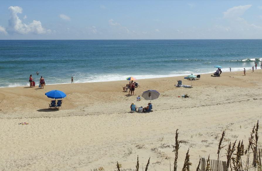
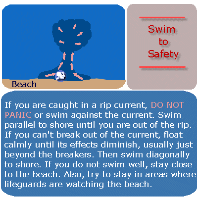 Forecasters, lifeguards warn: Rip currents are deadly
Not unlike getting a vehicle tune-up before a risky cross-country trip, emergency responders and weather officials are reinforcing the messaging about ocean safety as hundreds of thousands of beach lovers head to the coast for the July Fourth holiday. “In the Carolinas, rip currents are our biggest killer,” said Erik Heden, warning coordination meteorologist with the National Weather Service’s Newport/Morehead City office. Heden was speaking Thursday at the 2024 Eastern Carolinas Beach Hazards and Rip Currents Integrated Warning Team event held at Jennette’s Pier. In addition to representatives from the National Weather Service, the team included input from local emergency and public safety officials and ocean rescue personnel, as well as government communication representatives to discuss current and future beach safety issues. Since 2000, there have been 184 victims of rip current drownings in the Carolinas, 49% of whom were out-of-state residents, Heden said. Of them, 86% were male, most of them aged 41 to 50. Female victims were mostly between 31 and 40 years old. “That’s four times the number of deaths from tornados, floods and wind combined,” Heden said. The data didn’t include those who were caught in rips, but their deaths were attributed to an associated cause such as a heart attack, he added. About 100 fatalities annually in the U.S. are estimated from rip currents, and as much as 80% of all ocean rescues are rip current-related. But fortunately, there has been a lot of progress made in preventing the loss of life from rips, mostly by educating the public about the hazard, and by providing better tools to avoid the risk. To stretch the road trip metaphor, staying safe can come down to commonsense measures such as checking road conditions and the weather report. Going to the ocean should be no different. “Before we even get to the beach,” Heden said, “let’s talk about knowing some things.” Those “things” include questions such as: Where are lifeguarded beaches? What are conditions that day at the beach location? Do you need a floatation device? What is the rip current risk? Awareness can not only prevent drowning, but it can also mean not having to be saved by lifeguards. Recently, numerous news outlets reported that more than 150 beachgoers in New Hanover and Carteret counties and more than 80 at Carolina Beach alone were rescued from rip currents, which are channels of water typically formed at breaks in sand bars and that flow away from the beach. People can sign up for alerts on beach conditions and daily rip current risks at North Carolina beaches from the National Weather Service. Dare County also offers a service that provides alerts from Dare County lifeguards about local beaches. Beachgoers also need to know about other hazards that include lightning, another big weather-related killer. Leave the beach immediately if you hear thunder. Lightning strikes can happen when a storm is as far as 10 miles away. Several strikes on the Outer Banks have happened when people were in the parking lot after exiting the beach. Other risks ocean swimmers need to be aware of are shore break, that is, when a wave breaks forcefully in shallow water, and rogue waves that seemingly come out of nowhere and can throw a person into the surf. “They can be deceptive, and you don’t see them coming,” Hatteras Island Rescue Squad Supervisor Molly Greenwood said at a press briefing. “Never turn your back to the ocean.” Even something as seemingly harmless as walking on the sand is dangerous when temperatures are high, and the sun is strong. Ben Abe with Chicamacomico Banks Volunteer Fire Department water rescue said that one man suffered second-degree burns on the bottom of his feet from going barefoot on the beach and had to be transported to the hospital. In recent years, the National Weather Service has produced numerous informational videos and pamphlets about beach safety that are available through its website, including the award-winning “Play it Safe” series. The public information is geared to a fifth-grade education level, so it’s readily accessible for school-aged children, Heden said. “We do a tremendous amount of public education,” he added. Two important new infographics are focused on hazards that are related to rip currents but had often been overlooked in risk assessments. One provides advice to bystanders who want to help swimmers caught in a rip current or are struggling in the ocean, with a warning to call for help but not to enter the ocean without a floatation device. According to the weather service, nearly 30% of rip current drownings in the Carolinas since 2011 were bystanders trying to save another person. The other graphic illustrates the risk that far-offshore tropical storms create by intensifying the strength of currents, with a West Coast and East Coast version. Several videos and graphics are also offered in Spanish. The weather service beach forecast webpage will soon be transformed into a GIS-based platform, compatible with mobile devices, said Melinda Bailey, NWS National Marine Services program manager, who attended the event remotely. Web-based users will not have to download any proprietary software to access the platform, which is expected to be implemented by fall 2024, she added. “It’s a long time coming but it’s very exciting,” Bailey said. Bailey said the weather service has been working on predictive artificial intelligence models to improve accuracy of information on rip currents and other forecasting. Heden said that he looks forward to continued progress in beach safety through advancement in communication and predictive modeling tools, including cutting edge technology. “I’m intrigued by the virtual reality stuff,” he said. “It would be interesting to incorporate that.”
Learn more: National Weather Service Rip current brochure
https://coastalreview.org/wp-content/uploads/2024/06/rip_brochure_51419b.pdf
Read more » click here

These counties have the most shark attacks on North Carolina’s coast.
With tourists flocking to North Carolina beaches for the start of the summer, people will be diving into the home of many ocean creatures and that includes one of the most dangerous — sharks. The Florida Museum has an International Shark File as Florida is the top state for shark attacks in the United States. The file logs shark attacks all across the world and includes top attack states in the country, one of those states being North Carolina, which came in at No. 5.
Types of attacks
The International Shark File uses a number of different categorizations to describe attacks, including unprovoked bites, provoked bites, boat bites, scavenge, public aquaria, no assignment could be made and not confirmed.
Here are the worldwide statistics for shark attacks in 2023.
- Unprovoked bites: 69
- Provoked bites: 22
- Boat bites: 9
- Scavenge: 2 (post-mortem bites)
- Public Aquaria: 1
- No assignment could be made: 1
- Not confirmed: 16
How does North Carolina rank?
Out of all the states in the country, North Carolina ranks No. 5 for shark attacks behind its sister state South Carolina. North Carolina has had 80 confirmed unprovoked shark attacks since 1837. South Carolina has had 118, California has had 138, Hawaii has had 195 and Florida came in first at a whopping 928 unprovoked attacks.
County breakdown
Two of the Cape Fear region’s counties lead the numbers for confirmed unprovoked shark attacks since 1935 in North Carolina. Brunswick County tops the list with 18 attacks, followed by New Hanover County with 15 attacks.
Here’s the full list:
- Brunswick County: 18
- New Hanover County: 15
- Carteret County: 14
- Dare County: 11
- Onslow County: 10
- Hyde County: 4
- Currituck County: 3
- Pender County: 2
From 2012-2021, there have been a total of 31 bites in the state, but none of them have been fatal, according to the International Shark File.
What are the odds?
According to the Florida Museum, more people in the water has a strong correlation to the amount of attacks, which could point to why Brunswick County is at the top of the list for attacks on North Carolina’s coast as it is the fastest-growing county in the state. New Hanover County and Brunswick County are also part of the Wilmington Metro Area, which ranked No. 9 in the U.S. Census Bureau’s Top 10 U.S. Metro Areas from July 1, 2022, to July 1, 2023. But, although the chances are not zero, a person has a far greater chance of drowning than they do death by shark attack, according to the Florida Museum.
How to reduce the risk
Here are some tips provided by the Florida Museum to help keep yourself and others safe in the water this summer.
- Swim with a buddy.
- Stay close to shore.
- Don’t swim at dawn or dusk.
- Don’t swim around schools of fish or where people are fishing.
- Avoid wearing jewelry.
- Avoid excess splashing.
What to do when a shark is near
- Maintain eye contact with the shark.
- Slowly move away, and if possible, exit the water.
If the shark tries to bite you
- Hit shark in the eyes and gills —
Sensitive areas that can be hurt regardless of personal strength. - Hit the shark on the snout and push away —
Water-resistance weakens your punch.
- Hit shark in the eyes and gills —
Read more » click here
As weather warms, nesting shorebirds and sea turtles join people heading to NC’s beaches
With people flocking to the coast, officials hope education and outreach can help efforts to share the sand with nesting birds and sea turtles.
As the weather warms, sun-seeking tourists aren’t the only ones drawn to North Carolina’s rich necklace of barrier islands along its 320 miles of coastline. If you’re visiting the beach this summer, there’s a good chance you’ll see wildlife mixed in with visitors and the occasional resident. But sharing valuable beach real estate with nesting shorebirds and sea turtles can be challenging. Mix in the loss of habitat on many islands to development, the growing risk from climate change, and the increased threat of disturbance tied to human activities, dogs and even predators and the odds are often stacked against the native fauna. The eggs and chicks of nesting shorebirds often blend in perfectly with the sand, making it easy for people or pets to accidentally step on them. Getting close to the nests or babies can be just as bad, scaring the parents off and leaving the eggs and chicks at the mercy of predators and the summer heat. That’s where groups like the N.C. Wildlife Resources Commission and Audubon North Carolina come in to help level the playing field. Hundreds of signs ring the state’s coastal nesting sanctuaries from Currituck Sound in the north to Sunset Beach in the south, warning visitors to respect nesting areas. In some locations, including Wrightsville Beach, volunteers help reinforce that message. Hope Sutton, eastern wildlife diversity supervisor with the wildlife commission, said education and outreach efforts are some of the most powerful tools officials have to raise awareness about the birds’ requirements. “It’s a critical component, whether its students at Wrightsville Beach Elementary making cute signs to warn beachgoers to stay out of the refuge or adults learning about these birds through one of our outreach activities,” she said. “Our behavior patterns can really impact the chance of success many of these birds species have.” The helping hand comes as regulators worry about the future of some of the state’s shorebirds. North Carolina’s 2023 waterbird survey, which is conducted every three years and is a collaborative effort among government agencies and environmental groups, showed substantial dips in the numbers of many nesting shorebirds. Among wading birds, that list included cattle egrets, tricolored heron, little blue herons, snowy egrets and glossy ibis. Beach-nesting species showing substantial declines included the common tern, gull-billed tern, and Caspian tern. Another species that is in trouble is the black skimmer, with North Carolina’s population decreasing by half since 1999. Because skimmers nest directly on the open sand, they are especially vulnerable to disturbance and loss of nesting sites. But the survey wasn’t all bad news. Least tern numbers were found to be increasing, with many of the nests found on the beaches at the south end of Wrightsville Beach and on Lea-Hutaff Island in Pender County. Brown pelicans also are doing well, with 5,227 nests reported in 2023, well above the 15-year average of about 4,000 nests. Many of the shorebirds holding their own nest on spoil islands, like those in the Cape Fear River or Intracoastal Waterway, or on sections of protected natural areas like Masonboro Island that are hard to access. But climate change is an unknown variable that could add to the pressure many species face. On low-lying manmade dredge islands, for example, rising seas and stronger tropical storms tied to warming temperatures could increase erosion and over wash threats. “And the competition for sand is already tough and is likely to get worse in the coming decades,” Sutton said, referring to the limited nearshore sand resources and many coastal towns now seeking nourishment projects to boost their eroding beaches. A warming climate also could prompt some birds to nest sooner. Lindsay Addison, a coastal biologist with Audubon North Carolina, said learning to share the beach and knowing when to back away, such as when a shorebird starts acting irritated, can go a long way to help. “Anyone who has lived down here for a while knows that there are more and more people now, and sometimes it’s really hard to go anywhere along the coast and not run into a lot of people,” she said. “The birds also are experiencing that, and there are a lot of opportunities for people to disturb them and impact their survival. “But if we just keep our distance and take some other steps, like keeping our dogs on a leash during certain times, it can make a really huge difference.” Shorebird nesting season runs from March through mid-September.
Turtle time
Shorebirds aren’t the only ones looking to nest on area beaches. Peak sea turtle nesting season begins May 1 and continues through the end of October. Most local beaches are monitored daily during sea turtle nesting season to look for evidence of nests, which are then monitored and protected if needed during the roughly two-month incubation period. While sea turtle nesting numbers have been showing increases in recent years, regulators and environmentalists warn the marine reptiles still face many threats − especially during the decades they navigate the oceans before females return to their birth beach to nest. While on the beach, threats dangers include holes dug in the sand and left by beachgoers, which can trap hatchlings after they emerge from the nest, and bright lights from homes and businesses that can distract nesting mothers and hatchlings and lead them away from the ocean.
Sharing the beach
Tips from the N.C. Wildlife Resources Commission on how to share the beach with nesting wildlife this summer:
- Respect the boundaries of the roped-off nesting areas
- Keep dogs on a leash
- Follow beach driving regulations
- Throw away trash properly, including fishing line and kite strings
- Don’t feed sea gulls or least terns
- Don’t fly drones or kites near nesting sites
Read more » click here
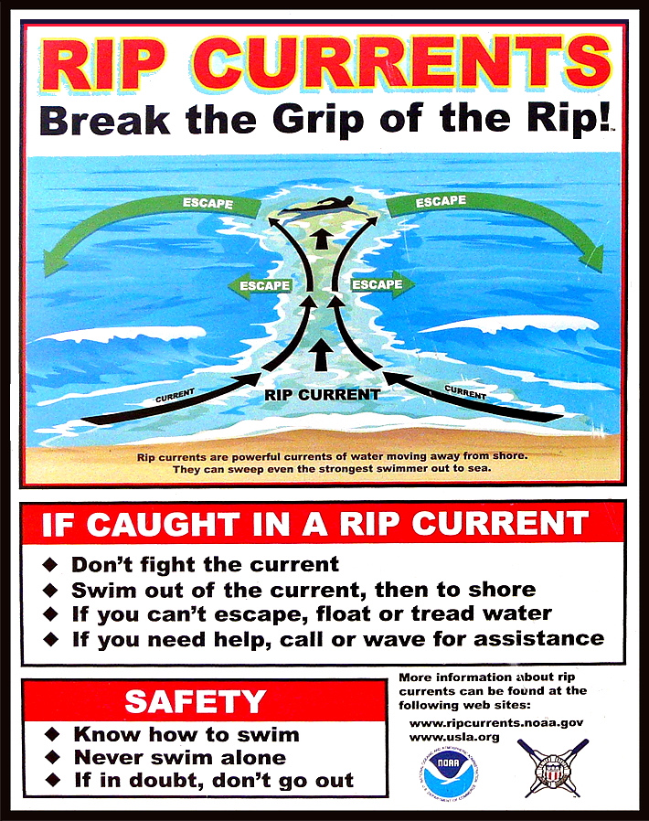
Most rip current deaths are preventable. Yet people keep drowning.
Beach-safety experts are frustrated by the mounting fatalities despite awareness campaigns and improved forecasts
Rip-current deaths in the United States are running ahead of last year’s pace — at least 29 since the beginning of the year — with peak beach season yet to come. Experts are warning the public to be aware of this largely hidden hazard ahead of Memorial Day weekend, traditionally one of the busiest beach weekends of the year. The risk of dangerous rip currents is expected to be particularly high this weekend along portions of the Southeast coast where a storm could produce heavy rain, gusty winds and rough seas. Experts say most rip-current fatalities can be prevented. Still, the number of annual rip-current deaths has steadily climbed since the National Weather Service began tracking them in 2010, reaching a record of 130 in 2021, then dipping to 85 last year. Rip currents were the third-leading cause of weather-related deaths from 2012 to 2021, behind only heat and flooding, according to the Weather Service, and in a typical year they kill more people than lightning, hurricanes or tornadoes. Rip currents are strong, narrow streams of water that flow away from the shoreline and can suddenly sweep swimmers out to sea. They can form on almost any beach with breaking waves, especially near low spots or breaks in sandbars, and near jetties or piers. Predicting where and when a rip current will form is difficult because of the many weather and ocean factors involved. The Weather Service cautions that “rip currents often form on calm, sunny days.” The Weather Service lists 26 rip-current deaths this year through April 27, not including three deaths believed to be caused by rip currents on April 28 in Destin, Fla., May 6 in Ocean City, Md., and May 12 at Cannon Beach, Ore. At this point last year, there were 19 total such deaths. Beach-safety experts are expressing frustration as fatalities trend higher again this year despite annual awareness campaigns, such as the United States Lifesaving Association’s National Beach Safety Week held every year during the week before Memorial Day, and recent improvements to rip current forecasts. “It is frustrating when we produce videos and graphics and educational information and release it at the beginning of each beach season, and it still misses so many people,” Scott Stripling, a senior meteorologist at the National Hurricane Center in Miami, said in an email. “The problem seems to be one of communication and/or lack of attention by the general public.”
Rip-current forecasts and warning signs
The Weather Service issues daily rip-current forecasts for beaches on the Atlantic Ocean, Gulf Coast, Southern California, Great Lakes, Puerto Rico and the U.S. Virgin Islands. The forecasts categorize the rip-current risk as low, moderate or high, and are informed by a rip-current model recently developed by NOAA that has made it possible to differentiate the risk between adjacent beaches. Previously the same forecast could span 100 miles or more. However, the model doesn’t enable reliable forecasts of the exact location and time of rip currents. These are influenced by a number of factors including wave characteristics, water levels, winds and the shape of a beach. Advances in artificial intelligence could help with rip-current detection — NOAA is partnering with the Southeast Coastal Ocean Observing Regional Association on a project using AI to detect rip currents in webcam imagery — but such efforts are still in their infancy. In some cases, there are visible clues to the existence of a rip current, such as a break in the waves, foamy water or objects being carried offshore, or darker water that is due to a break in a sandbar. Often, though, rip currents are difficult to see, or are best seen from a high point such as a dune line or the top of a beach access. Rip currents are particularly hard to spot in South Florida, where, the Weather Service says, they “consistently rank at or near the top of the list of deadliest weather-related hazards,” because there is not much sediment to darken or muddy the current at the shoreline. In Brevard County alone, home to nearly 72 miles of sandy beaches, there have been eight apparent rip-current drownings since November, all at beaches without lifeguards. “We have clear-water rips, so these offshore-flowing currents are very hard to detect,” Stephen Leatherman, a professor in the department of earth and environment at Florida International University, said in an email. “The best thing is to have lifeguards and for people to swim close to lifeguards. But lifeguards are very expensive, and Florida has 825 miles of good quality sandy beaches which are swimmable for most of the year.”
Warnings and tips for surviving a rip current
Rip currents flow at speeds up to 5 miles per hour. That may not sound fast, but it’s faster than many Olympic swimmers. If you are caught in a rip current, experts say not to swim directly back to shore against the current, which can quickly exhaust and drown you. Instead, swim parallel to the shore until you are out of the current, which is typically no wider than about 50 to 100 feet. You might also escape by floating or treading water, allowing the current to take you out just past the breaking waves where many rip currents tend to dissipate, and then circulate you back toward the shore. However, some rip currents can extend hundreds of yards offshore. If you see someone caught in a rip current, experts urge you not to risk your own life to attempt a swimming rescue unless you have been trained to do so and have a flotation device to assist you and the person in distress. Instead, you should get help from a lifeguard or call 911 if no lifeguard is present. You should also throw the victim something that floats, such as a lifejacket, body board, cooler or a ball, and yell instructions on how to escape. Experts agree that the best way to survive a rip current is to avoid it in the first place. That means checking the rip-current forecast before you enter the water, heeding warnings for rip currents or rough surf, and only swimming close to a lifeguard. The United States Lifesaving Association estimates the chance of someone’s drowning at a beach with a lifeguard at 1 in 18 million. “Lifeguards are trained to spot rip currents and other beach hazards and intervene as and when needed,” Chris Houser, a professor at the University of Windsor School of Environment and a longtime beach-safety researcher, said in an email. “While there is some evidence that individual beach users can be trained to spot rips, most beach users are not aware of what to look for.” U.S. lifeguards make an estimated 80,000 or more rip-current rescues each year, which suggests that education and warning messages are not reaching or are not resonating with as many people as experts would like. “If the lifeguards are flying precautionary flags, and there are signs on the lifeguard stand identifying the potential for rips in that area, and the National Weather Service and media have advertised that there is at least a moderate risk for rip currents to be present at your local beach, what else can we do?” the Weather Service’s Stripling said.
Read more » click here

 Staying safe at the beach: Rip currents, jellyfish, sharks, and other hazards
A trip to the beach can turn deadly (or painful) due to natural hazards but being aware of risks and mitigating hazards is a good way to prevent problems.
Picture this: warm weather, blue skies, and your toes in the sand — it sounds like a perfect lazy summer day at the beach. Maybe you decide to cool down in the ocean and find yourself bobbing around when suddenly you realize you are a little too far out. As panic sinks in and you start to swim towards dry land you realize your efforts are in vain and your whole body is getting tired, all the while you are drifting further into the Atlantic — you have gotten stuck in a rip current. It’s not the only potential danger in the ocean, though. There are also sharks. And, of course, there are some things on shore that ruin your day at the beach, too, including stepping on jellyfish and, of course, good old-fashioned sunburn.
Rip currents
According to the U.S. Lifesaving Association (USLA), 80 percent of all ocean rescues are related to rip currents and annually more than 100 fatalities across the country are due to rip currents. While it is obvious that swimming at a beach with lifeguards is one of the safer options, there are plenty of area beaches that lack lifeguards or maybe ocean rescue season has not started just yet. So, what is the best course of action for surviving a rip current? According to the National Weather Service, there are several things swimmers should keep in mind when dealing with these often-unseen dangers.
- Relax. Rip currents don’t pull you under.
- A rip current is a natural treadmill that travels an average speed of 1-2 feet per second but has been measured as fast as 8 feet per second — faster than an Olympic swimmer. Trying to swim against a rip current will only use up your energy; energy you need to survive and escape the rip current.
- Do NOT try to swim directly into to shore. Swim along the shoreline until you escape the current’s pull. When free from the pull of the current, swim at an angle away from the current toward shore.
- If you feel you can’t reach shore, relax, face the shore, and call or wave for help. Remember: If in doubt, don’t go out!
- If at all possible, only swim at beaches with lifeguards.
- If you choose to swim on beaches without a lifeguard, never swim alone. Take a friend and have that person take a cell phone so he or she can call 911 for help.
Sharks
Sharks are a fear on most every swimmer’s mind, regardless of the actual dangers posed by the large predatory fish. “NOAA states that while shark attacks are rare, they are most likely to occur near shore, typically inshore of a sandbar or between sandbars where sharks can be trapped by low tide, and near steep drop-offs where sharks’ prey gather. While the risks are small, it’s important to be aware of how to avoid an attack,” according to previous reporting.
Suggestions from NOAA for reducing the risk of a shark attack include:
- Don’t swim too far from shore.
- Stay in groups – sharks are more likely to attack a solitary individual.
- Avoid being in the water during darkness or twilight when sharks are most active.
- Don’t go in the water if bleeding from a wound – sharks have a very acute sense of smell.
- Leave the shiny jewelry at home – the reflected light resembles fish scales.
- Avoid brightly-colored swimwear – sharks see contrast particularly well.
Sunburns
Most everyone has experienced a sunburn at one point in their life and while not often thought as a major concern for many, overexposure to UV light can cause serious long-term problems including skin cancer. The Centers for Disease Control and Prevention (CDC) recommends using at least S.P.F. 15 sunscreen at least 15 minutes prior to sun exposure. Wearing a hat, long sleeves, and other protective clothing is also recommended to keep skin protected.
Jellyfish
Jellyfish and Portuguese Man of War have been spotted along the beaches of New Hanover County and surrounding area beaches already this season and the little floating creatures can pack a punch. Often times beachgoers will spot them washed up on shore and other times they can be spotted in the water, but it is best to avoid them when you can. “While all jellyfish sting, not all contain poison that hurts humans. Be careful of jellies that wash up on shore, as some can still sting if tentacles are wet. NOAA recommends that if you are stung by a jellyfish to first seek a lifeguard to give first aid. If no lifeguards are present, wash the wound with vinegar or rubbing alcohol,” NOAA suggests. And what about that … other method of treating stings? Turns out, it’s a myth. In fact, urine can actually aggravate the stinging cells of jellyfish, making things worse. These cells, which detach and stick into the skin of prey, can continue to inject venom. Urine, as well as fresh water, can cause an imbalance to the salt solution surrounding the stinging cells, causing them to continue to fire. According to Scientific American, if you don’t have vinegar or rubbing alcohol, rinsing with salt water may be your best bet.
Read more » click here

Hot Button Issues –
Subjects that are important to people and about which they have strong opinions

Climate
For more information » click here.
There’s something happening here
What it is ain’t exactly clear

Flood Insurance Program
For more information » click here

National Flood Insurance Program: Reauthorization
Congress must periodically renew the NFIP’s statutory authority to operate. On March 22, 2024, the president signed legislation passed by Congress that extends the National Flood Insurance Program’s (NFIP’s) authorization to September 30, 2024.
Congress must now reauthorize the NFIP
by no later than 11:59 pm on September 30, 2024.

GenX
For more information » click here

Homeowners Insurance
For more information » click here

Hurricane Season
For more information » click here
 NOAA predicts above-normal 2024 Atlantic hurricane season
Read more » click here
2024 Hurricane Season Is Expected to Be Abnormally Busy, NOAA Predicts
The Atlantic hurricane season is looking to be an extraordinary one, with 17 to 25 named storms predicted, experts said.
In yet another dire warning about the coming Atlantic hurricane season, the National Oceanic and Atmospheric Administration on Thursday predicted that this year could see between 17 to 25 named tropical cyclones, the most it has ever forecast in May for the Atlantic Ocean. The NOAA forecast joins more than a dozen other recent projections from experts at universities, private companies and other government agencies that have predicted a likelihood of 14 or more named storms this season; many were calling for well over 20. Rick Spinrad, the NOAA administrator, said at a news conference on Thursday morning that the agency’s forecasters believed eight to 13 of the named storms could become hurricanes, meaning they would include winds of at least 74 miles per hour. Those could include four to seven major hurricanes — Category 3 or higher — with winds of at least 111 m.p.h.
According to NOAA, there is an 85 percent chance of an above-normal season and a 10 percent chance of a near-normal season, with a 5 percent chance of a below-normal season. An average Atlantic hurricane season has 14 named storms, including seven hurricanes and three major hurricanes. While it only takes one storm in a below-average season to devastate a community, having conditions conducive to almost twice the average amount of storms makes it more likely that North America will experience a tropical storm or, worse, a major hurricane. There are 21 entries on this year’s official list of storm names, from Alberto to William. If that list is exhausted, the National Weather Service moves on to an alternative list of names, something it’s only had to do twice in its history. NOAA typically issues a May forecast and then an updated forecast in August. Before Thursday, NOAA’s most significant May forecast was in 2010, when it forecast 14 to 23 named storms; that year, 19 ultimately formed before the end of the season. In 2020, the May forecast was for 13 to 19 named storms, but an updated forecast for August was even higher, with 19 to 25 named storms. That season ultimately saw 30 named storms. The hurricane outlooks this year have been notably aggressive because of the unprecedented conditions expected. As forecasters look toward the official start of the season on June 1, they see combined circumstances that have never occurred in records dating to the mid-1800s: record warm water temperatures in the Atlantic and the potential formation of La Niña weather pattern. Brian McNoldy, a researcher at the University of Miami who specializes in hurricane formation, said that without a previous example involving such conditions, forecasters trying to predict the season ahead could only extrapolate from previous outliers.
Experts are concerned by warm ocean temperatures.
“I think all systems are go for a hyperactive season,” said Phil Klotzbach, an expert in seasonal hurricane forecasts at Colorado State University. The critical area of the Atlantic Ocean where hurricanes form is already abnormally warm just ahead of the start of the season. Benjamin Kirtman, a professor of atmospheric sciences at the University of Miami, earlier described the conditions as “unprecedented,” “alarming” and an “out-of-bounds anomaly.” Over the past century, those temperatures have increased gradually. But last year, with an intensity that unnerved climate scientists, the waters warmed even more rapidly in a region of the Atlantic where most hurricanes form. This region, from West Africa to Central America, is hotter this year than it was before the start of last year’s hurricane season, which produced 20 named storms. The current temperatures in the Atlantic are concerning because they mean the ocean is poised to provide additional fuel to any storm that forms. Even if the surface suddenly cools, the temperatures below the surface, which are also remarkably above average, are expected to reheat the surface temperatures rapidly. These warmer temperatures can give energy to the formation of storms — and help sustain them. Sometimes, if no other atmospheric conditions hinder a storm’s growth, they can intensify more rapidly than usual, jumping hurricane categories in less than a day. Combined with the rapidly subsiding El Niño weather pattern in early May, the temperatures are leading to mounting confidence among forecasting experts that there will be an exceptionally high number of storms this hurricane season.
A parting El Niño and a likely La Niña are increasing confidence in the forecasts.
El Niño is caused by changing ocean temperatures in the Pacific and affects weather patterns globally. When it is strong, it typically thwarts the development and growth of storms. Last year, the warm ocean temperatures in the Atlantic blunted El Niño’s effect to do that. If El Niño subsides, as forecasters expect, there won’t be much to blunt the season this time. Forecasters specializing in the ebbs and flows of El Niño, including Michelle L’Heureux with the National Weather Service’s Climate Prediction Center, are pretty confident not only that El Niño will subside but that there is a high likelihood — 77 percent — that La Niña will form during the peak of hurricane season. The system could throw a curve ball, she said, but at this point in the spring, things are evolving as forecasters have anticipated. A La Niña weather pattern would already have them looking toward an above-average year. The possibility of a La Niña, combined with record sea surface temperatures this hurricane season, is expected to create a robust environment this year for storms to form and intensify.
Read more » click here
 Brunswick County reminds public to prepare for 2024 Atlantic hurricane season
June marks the start of the Atlantic hurricane season, which runs from June 1 through November 30, and the National Oceanic and Atmospheric Administration (NOAA) predicts that it will be an above-normal hurricane season this year. Brunswick County encourages all community members to start preparing now.
For the 2024 Atlantic hurricane season, NOAA is forecasting a range of 17 to 25 total named storms. Of those, 8 to 13 could become hurricanes, including 4 to 7 major hurricanes.
Based on 30 years of climate data collected from 1991 to 2020, NOAA found that the average Atlantic hurricane season has 14 named storms (winds of 39 mph or higher), 7 hurricanes (winds of 74 mph or higher), and 3 major hurricanes (category 3, 4, or 5; with winds of 111 mph or higher).
“Many people move to Brunswick County who have never experienced a hurricane before,” Brunswick County Emergency Management Director David McIntire said. “Living in our coastal region comes with the risk of life-threatening weather events such as hurricanes. We urge all our residents and visitors to stay prepared, stay informed, and stay ready.”
Ways to Prepare for Hurricane Season
- Make a plan. Create and practice a family emergency plan that includes all members of your household and pets. Discuss who your emergency contacts are, your evacuation route, shelter plan, forms of identification for your pets and animals, how you will receive emergency alerts, where you will store important documents, and what you will put in your emergency supply kit.
- Build a kit. An emergency kit is vital for your survival in situations where help might not be easily accessible due to power outages and road damage. When preparing an emergency kit, it is recommended to prepare three to seven days-worth of medicine, water, and non-perishable food for each person and pet in your home.
- The North Carolina Cooperative Extension – Brunswick County Center has prepared a hurricane cookbook and a Hurricane Meal Kits program to help individuals and families prepare nutritious meals ahead of an emergency.
- Stay informed. Sign up for ReadyBrunswick emergency notifications, subscribe to the County’s email list, sign up for the Access and Functional Needs Registry, and follow Brunswick County and the National Weather Services (NWS) on social media.
- Know your zone. Visit the North Carolina Department of Public Safety’s Know Your Zone webpage to view the area’s most at risk of storm surges and flooding in Brunswick County. Local officials use the zones to determine which areas should be evacuated in case of an emergency.
- Know the terms. A Hurricane Watch indicates hurricane conditions are possible. A Hurricane Warning indicates hurricane conditions are expected.
- Check your insurance. Before an emergency strikes, review your insurance policies to ensure your property is covered for any flooding or natural disasters that could occur. Flood insurance, which is not normally part of homeowner’s insurance policies, is encouraged for North Carolina residents.
For more hurricane preparedness tips from Brunswick County, visit brunswickcountync.gov/hurricanes.
Find information on emergency planning and hurricane safety online at ReadyNC.gov or Ready.gov.
View updates from the National Hurricane Center, a real-time emergency weather map, and additional online resources at nhc.noaa.gov.
Read more » click here

Inlet Hazard Areas
For more information » click here
.
Lockwood Folly Inlet
For more information » click here.

Seismic Testing / Offshore Drilling
For more information » click here.

Offshore Wind Farms
For more information » click here
Things I Think I Think –
 Eating out is one of the great little joys of life.
Restaurant Review:
The Dinner Club visits a new restaurant once a month. Ratings reflect the reviewer’s reaction to food, ambience and service, with price taken into consideration.
///// December 2021
Name: Ceviche’s
Cuisine: Panamanian
Location: 7210 Wrightsville Avenue, Wilmington NC
Contact: 910.256.3131 / https://www.wbceviche.com/
Food: Average / Very Good / Excellent / Exceptional
Service: Efficient / Proficient / Professional / Expert
Ambience: Drab / Plain / Distinct / Elegant
Cost: $26 Inexpensive <=20 / Moderate <=26 / Expensive <=35 / Exorbitant <=60
Rating: Three Stars
Ceviche’s is a Latin America seafood restaurant ranked #5 out of @492 restaurants located in Wilmington. It is located on Wrightsville Avenue, just before the bridge. They offer a creative Panamanian inspired menu specializing in serving ceviche which is a seafood dish popular in the coastal regions of Latin America. The dish is typically made from fresh raw fish marinated in citrus juices and spiced with various peppers. It is a very busy place, which is filled nearly every evening. The cuisine is fresh and interesting, it’s a nice change from the same old same old. We enjoyed the dining experience at this place, it was – Delightful!
It’s been 10 years of fresh and tropical fun at this Wrightsville Beach restaurant
Hunter and Laura Tiblier didn’t have restaurant experience before opening Ceviche’s at 7120 Wrightsville Ave. near Wrightsville Beach in 2014. But after a career in the military, he wanted to do something new and was inspired by his childhood in Panama. The couple thought if they were to go into the hospitality industry, it should bring Hunter Tiblier’s ceviche to Wilmington, and they would do it their own way. This year, they celebrate 10 years doing just that. They’ve become well known for their fresh and fun contributions to the local dining scene. People love their indoor and outdoor dining areas that seem to spill out of the restaurant. They love the ceviche (of course) and the coconut shrimp. As far as cocktails, the margaritas, which come in flavors like pineapple, mango and watermelon are the No. 1 seller.
New chef, new menu
The Tibliers have added chef Dwayne Hickman to their staff in December. And while the menu has been honed to include those dishes that consistently work, they do tweak it seasonally and for specials. In April, they introduced some new and returning dishes for the busy season. The fan-favorite Watermelon Salad, with pickled red onion, cucumber, cashews, queso fresco and basil vinaigrette, is back. And there’s a new version of the popular El Quatro ceviche sampler. The La Niña has smaller, two-ounce portions of them.
Accolades galore
The most recent bit of national recognition came when Ceviche’s was named one of the 20 best restaurants in Wilmington by Southern Living magazine and was featured in the accompanying article about this area being “The South’s Best City On The Rise.” Before that, Guy Fieri visited Ceviche’s in 2018 for the “Diners, Drive-ins and Dives” Food Network show. They prepared the ropa vieja (or braised flank steak in a peppery tomato broth) and sancocho, which is also known as Panama’s national dish for Fieri. The latter is a soup of chicken, sweet potato, yucca, plantains, and corn mixed with a spicy cilantro broth and served with a side of coconut rice.
A celebration ahead
The Tibliers and their team are still planning how they will honor their 10th anniversary in September. It will likely include lots of specials, and perhaps an appearance from their favorite Panamanian band. Look for more details in the coming months.
Read more » click here
 Cloud 9
9 Estell Lee Pl
Wilmington, North Carolina 28401
910.726.9226
Rooftop Bar
https://cloud9ilm.com/
Enjoy panoramic views from the Cloud 9 rooftop bar which overlooks picturesque downtown Wilmington. This premier open-air rooftop venue is located on the Riverwalk in downtown Wilmington on the ninth floor of the Embassy Suites. The bar is open seven (7) days a week at 4:00 PM and is currently serving almost fifty (50) different brews on tap and in cans and more than 20 wine selections. They also offer live music Thursday through Saturday evenings throughout the summer months. This is a must visit the next time you are in Wilmington.
Dining Guide – Local
Old places, New faces
Name: SmacNally’s
Location: 1045 B-Var Road, Supply NC
This spot that was once known as Betty’s Waterfront Restaurant before reopening in 2020 as LouLou’s Waterfront Restaurant. LouLou’s has permanently closed. They weren’t closed long before a new eatery was announced for the space. Owners of SmacNally’s Waterfront Bar & Grill are planning a second location for 1045 B-Var Road S.W. in Supply.
Popular Outer Banks seafood restaurant planning a second location in Brunswick County
For 25 years, SmacNally’s Waterfront Bar & Grill has been serving fresh seafood and burgers in Ocracoke. Now, the owners are planning to expand the brand for the first time, and they’ll be doing so in Brunswick County. Scott McNally announced that they’ll be taking over the recently closed LouLou’s Waterfront Restaurant on the Intracoastal Waterway at 1045 B-Var Road S.W. in Supply. “It’s time,” McNally said. “We’ve put a lot into this brand and it’s time to grow.” McNally has decades of experience in restaurants, and together with partners Tom Burruss, Matt Bacheler and Persell Morgan, they have more than 120 years in hospitality. One caveat is they wanted to continue with the waterfront restaurant tradition that’s close to local seafood. It made the Holden Beach area ideal. “At SmacNally’s we work with fishermen, and we have a fish cleaning counter right at the end of our dock. They bring it right from there, to our restaurant. It’s usually just hours from the ocean.” That dock-to-kitchen model is one they’d like to continue in Holden Beach. If that’s not possible, they still plan to work with local markets for the freshest seafood, he said. LouLous restaurant opened in fall 2020 in what was formerly Betty’s Waterfront Restaurant. The space has indoor and outdoor dining, a bar area and slips for boat parking. McNally said they hope to open the SmacNally’s in May. “Or sooner, if possible,” he said.
Read more » click here
Peach Cobbler Factory
The dessert chain that also has a location in Carolina Beach has opened a mobile unit (with delivery options) in Holden Beach. The menu includes a variety of cobblers, puddings, cinnamon rolls and other desserts at 3247 Holden Beach Road S.W.

Dining Guide – Local * Lou’s Views (lousviews.com)
Dining Guide – North * Lou’s Views (lousviews.com)
Dining Guide – South * Lou’s Views (lousviews.com)
Restaurant Reviews – North * Lou’s Views (lousviews.com)
Restaurant Reviews – South * Lou’s Views (lousviews.com)
Book Review:
Read several books from The New York Times best sellers fiction list monthly
Selection represents this month’s pick of the litter

FIRST LIE WINS by Ashley Elston
Evie Porter is a professional con artist whose specialty is insinuating herself into people’s lives, gaining their trust so she can expose their secrets.Evie develops feelings for her current mark and realizes that her latest job from her mysterious employer has become more personal and dangerous than planned.
 LISTEN FOR THE LIE by Amy Tintera
Lucy can’t remember the night her best friend was murdered. Though Lucy was never charged, almost everyone in town still believes she killed her. It’s five years later, and Ben the moderator for the true-crime podcast “Listen for the Lie,” decides to investigate the unsolved murder of her friend Savvy’s death. Lucy returns home to solve her friend’s murder, working with Ben as he searches for the truth.
That’s it for this newsletter
See you next month
Lou’s Views . HBPOIN
. • Gather and disseminate information
. • Identify the issues and determine how they affect you
. • Act as a watchdog
. • Grass roots monthly newsletter since 2008