
Lou’s Views
News & Views / August Edition
Lou’s Views newsletter email distribution are currently sent from [email protected]. Our email distribution is changing, we are migrating from MadMimi to Constant Contact. Which means the newsletter will arrive in your mailbox from a different address.
The e-mails will now be sent to you from [email protected].

Calendar of Events –

U.S. Open King Mackerel Fishing Tournament
October 3rd thru 5th
Southport
The U.S. Open King Mackerel Tournament has taken place since 1979 and is held annually the first week in October. The U.S. Open is one of the largest king mackerel tournaments on the East Coast and part of the SKA (Southern Kingfish Association) Tournament Trail. The tournament now attracts almost 400 boats annually.
For more information » click here

Riverfest
October 5th & 6th
Wilmington
.
.
Wilmington’s Riverfest is celebrated in October since 1979 and runs from the foot of Market Street to Cape Fear Community College over a half mile of free family entertainment.
For more information » click here
![]()
Sunset at Sunset
October 5th
Sunset Beach
Held the first Saturday in October each year, Sunset at Sunset is the Town of Sunset Beach’s Community Block Party. The annual autumn event has been celebrated since 2007, and is scheduled to happen again this year, in front of Ingram Planetarium on Sunset Boulevard in Sunset Beach.
For more information » click here

Run Holden Beach
October 5th
Holden Beach
.
.
Run Holden Beach is part of the BAM! Race Series that started in 2014. The series includes four (4) events that have runs on Holden Beach, Oak Island, Sunset Beach, and Ocean Isle Beach.
For more information » click here
![]()
N.C. Oyster Festival
October 19th & 20th
Ocean Isle Beach
.
..
..
The annual North Carolina Oyster Festival has been taking place since 1978. Come celebrate everything Oyster with a variety of foods, crafts, contests, children’s activities, and musical performances at Mulberry Park in Shallotte. Signature Festival events include the Oyster Shucking Contest, Oyster Eating Contest, and Oyster Stew Cook-off.
For more information » click here

N.C. Festival by the Sea
October 26th & 27th
Holden Beach
.
Hosted by the Holden Beach Merchants Association this annual two-day festival which started in the 1980’s occurs on the last full weekend in October. The festival is kicked off with a parade down the Holden Beach causeway. There is a fishing tournament, horseshoe tournament, and a sandcastle building contest. Vendors provide food, arts and crafts, amusement rides and other activities. There is live musical entertainment both days at the Holden Beach’s Pavilion.
For more information » click here
![]() Discover a wide range of things to do in the Brunswick Islands for an experience that goes beyond the beach.
Discover a wide range of things to do in the Brunswick Islands for an experience that goes beyond the beach.
For more information » click here.
Calendar of Events Island –

Concerts on the Coast Series
The Town’s summer concert series calendar has been released! Live performances featuring local musical groups will temporarily be held at the Bridgeview Park picnic pavilion on Sunday evenings from late May to early September. The concerts are free of charge.
For more information » click here
The park will be blocked from vehicular access beginning Saturday evening. The splash pad will be closed on Sundays and the multipurpose court will close at 3:00 p.m. each Sunday. No seating will be provided so everyone should bring their own chair for the event.
 Shag Lessons
The Town of Holden Beach is taking names for an interest list for shag lessons at the Holden Beach Town Hall on Wednesday evenings, beginning October 16th and going through November 20th. The cost is $60 for residents for the series and $70 for non-residents. Beginners’ classes will run from 5:30-6:30 p.m. and intermediate from 6:30-7:30 p.m. You must have a dance partner in order to sign up. The instructor for the class will be Chuck Boney and participants will pay him directly. Register by emailing Christy at [email protected].
Note: The classes will only be held if there is enough interest.
Parks & Recreation / Programs & Events
For more information » click here
Reminders –
 Free Cleanup Week
The Brunswick County Solid Waste and Recycling Division hosts two free clean up weeks a year, the third week in April and September. The next Free Cleanup Week at the Brunswick County Landfill will take place September 16th – 21st. Brunswick County property owners and residents can dispose of all materials, except for regular household trash and hazardous waste, at the Brunswick County Landfill free of charge during Free Cleanup Week events. Individuals can dispose of metal, tires, electronics, appliances, latex paint, clothing, shoes, used oil, oil filters, antifreeze, gasoline, fluorescent bulbs, used cooking oil, smoke detectors, household batteries, and yard debris in their designated areas at the landfill during this week. Participants must show proof of Brunswick County property ownership or residency.
Businesses and commercial vehicles will be charged normal tipping fees.
For questions, email Brunswick County Operation Services or call 910-253-2520.
LOCATION
Brunswick County Landfill
172 Landfill Rd NE
Bolivia, NC 28422
HOURS OF OPERATION
Monday through Friday :30 a.m. until 5:00 p.m.
Saturday 7:30 a.m. until 3:00 p.m.
 News from Town of Holden Beach
The town sends out emails of events, news, agendas, notifications, and emergency information. If you would like to be added to their mailing list, please go to their web site to complete your subscription to the Holden Beach E-Newsletter.
For more information » click here
 THB Newsletter (03/30/24)
Paid Parking
Paid parking will be enforced starting April 1st in all Holden Beach designated parking areas. It will be enforced from 9:00 a.m. – 5:00 p.m. daily, with free parking before and after that time. All parking will use license plates for verification.
As a reminder, Holden Beach uses the “SurfCAST by Otto” parking solution. Annual passes are now available for purchase on the mobile app. You will also be able to purchase passes by scanning the QR-codes located on the parking signs for access to https://surfcast.ottoconnect.us/pay.
Rates for the 2024 season are as follows:
$5 per hour for up to four hours
$20 per day and for any duration greater than four hours
$80 per week (seven consecutive days)
$175 per calendar year for a single vehicle (annual passes)
Handicap parking is free in designated handicap spaces and only with a valid license plate or hangtag.
Parking rates can be paid via credit card, debit card or PayPal.
Visit https://hbtownhall.com/paid-parking for more information and to view a table with authorized parking areas.

Pets on the Beach Strand
Pets – Chapter 90 / Animals / 90.20
From May 20th through September 10th it is unlawful to have any pet on the beach strand during the hours of 9:00am through 5:00pm.

Solid Waste Pick-Up Schedule
GFL Environmental change in service, trash pickup will be twice a week.Starting the Saturday before Memorial Day through the Saturday after Labor Day: Pick-up is every Tuesday and Saturday from May 25th through September 30th
Please note:
. • Trash carts must be at the street by 6:00 a.m. on the pickup day
. • BAG the trash before putting it in the cart
. • Carts will be rolled back to the front of the house
GFL Refuse Collection Policy
GFL has recently notified all Brunswick County residents that they will no longer accept extra bags of refuse outside of the collection cart. This is not a new policy but is stricter enforcement of an existing policy. While in the past GFL drivers would at times make exceptions and take additional bags of refuse, the tremendous growth in housing within Brunswick County makes this practice cost prohibitive and causes drivers to fall behind schedule.
Solid Waste Pick-up Schedule –
starting the Saturday before Memorial Day (May 25th) twice a week
Recycling –
starting after Memorial Day (June 4th) weekly pick-up
Curbside Recycling – 2024
GFL Environmental is now offering curbside recycling for Town properties that desire to participate in the service. The service cost per cart is $106.88 annually paid in advance to the Town of Holden Beach. The service consists of a ninety-six (96) gallon cart that is emptied every other week during the months of October – May and weekly during the months of June – September.
Curbside Recycling Application » click here
Curbside Recycling Calendar » click here

Trash Can Requirements – Rental Properties
GFL Environmental – trash can requirements
Ordinance 07-13, Section 50.08
Rental properties have specific number of trash cans based on number of bedrooms.
* One extra trash can per every 2 bedrooms
..
§ 50.08 RENTAL HOMES.
(A) Rental homes, as defined in Chapter 157, that are rented as part of the summer rental season, are subject to high numbers of guests, resulting in abnormally large volumes of trash. This type of occupancy use presents a significantly higher impact than homes not used for summer rentals. In interest of public health and sanitation and environmental concerns, all rental home shall have a minimum of one trash can per two bedrooms. Homes with an odd number of bedrooms shall round up (for examples one to two bedrooms – one trash can; three to four bedrooms – two trash cans; five – six bedrooms – three trash cans, and the like).
Building Numbers
Ocean front homes are required to have house numbers visible from the beach strand.
Please call Planning and Inspections Department at 910.842.6080 with any questions.
§157.087 BUILDING NUMBERS.
(A) The correct street number shall be clearly visible from the street on all buildings. Numbers shall be block letters, not script, and of a color clearly in contrast with that of the building and shall be a minimum of six inches in height.
(B) Beach front buildings will also have clearly visible house numbers from the strand side meeting the above criteria on size, contrast, etc. Placement shall be on vertical column supporting deck(s) or deck roof on the primary structure. For buildings with a setback of over 300 feet from the first dune line, a vertical post shall be erected aside the walkway with house numbers affixed. In all cases the numbers must be clearly visible from the strand. Other placements may be acceptable with approval of the Building Inspector.
 Bird Nesting Area
NC Wildlife Commission has posted signs that say – Bird Nesting Area / Please don’t disturb. The signs are posted on the west end beach strand around 1335 OBW.
.
People and dogs are supposed to stay out of the area from April through November
. 1) It’s a Plover nesting area
. 2) Allows migrating birds a place to land and rest without being disturbed

A Second Helping
.
Program to collect food Saturday mornings (8:00am to 10:30am) during the summer at the Beach Mart on the Causeway.
1) Twentieth year of the program
2) Food collections have now exceeded 298,000 pounds
3) Collections will begin on Memorial Day weekend
4) Food is distributed to the needy in Brunswick County
For more information » click here
.
Hunger exists everywhere in this country; join them in the fight to help end hunger in Brunswick County. Cash donations are gratefully accepted. One hundred percent (100%) of these cash donations are used to buy more food. You can be assured that the money will be very well spent.
Mail Donations to:
A Second Helping
% Sharon United Methodist Church
2030 Holden Beach Road
Supply, NC 28462
Storm Events –

Hurricane Vehicle Decals
Property owners will be provided with four (4) decals which were included in their April water bills. It is important that you place your decals in your vehicle or in a safe place. A $10 fee will be assessed to anyone who needs to obtain either additional or replacement decals. Decals will not be issued in the 24-hour period before an anticipated order of evacuation.
The decals are your passes to get back onto the island to check your property in the event that an emergency would necessitate restricting access to the island. Decals must be displayed in the driver side lower left-hand corner of the windshield, where they are not obstructed by any other items. Officials must be able to clearly read the decal from outside the vehicle.
Property owners without a valid decal will not be allowed on the island during restricted access. No other method of identification is accepted in an emergency situation. Click here to visit the Town website to find out more information regarding decals and emergency situations.
EVACUATION, CURFEW & DECALS
What is a State of Emergency?
A proclamation by the Town which enacts special ordinances and/or prohibitions during emergency situations to protect the public, public health and property. These prohibitions can include limitations on movement, curfews, directing of evacuations, controlling ingress and egress to the emergency area, alcoholic beverages, and more. State of Emergencies are issued in accordance with N.C.G.S. 166A-19.22.
What is a curfew?
A curfew is an order, typically during a State of Emergency, which requires all persons in the affected areas to remain on their own property. During a curfew, you are not free to move about public domain areas or on others’ property. Violations of a curfew could lead to arrest in certain situations.
What is a voluntary evacuation?
A voluntary evacuation creates a recommendation for all parties in the affected area to get their affairs in order hastily and evacuated.
What is a mandatory evacuation?
A mandatory evacuation means you must leave the area in which an order has been issued. With recent changes to the laws in North Carolina, you no longer have the option of staying in an area under an order of mandatory evacuation.
Why is the sewer system turned off during a storm/event?
Often the sewer system is turned off during storms which have the potential to create significant flooding on the island. The system is turned off to protect its integrity. If it were left on, it could pose a significant threat to the public health. When the system is manually shut down, it also greatly reduces the time needed to bring it back up after an event which equates to getting residents and guests back on the Island much faster.
Why is there a delay for decal holders to get back on the island once a storm ends?
After a storm, many things must occur before even limited access can be allowed. Some of those things include making sure the streets are passable; the sewer system must be restarted to comply with State laws; the utilities (water, sewer, electricity, propane supplies) must be checked to ensure no safety risk are present; and the post-storm damage assessment team needs to perform an initial assessment.
Where can I get up-to-date information during and after a storm or State of Emergency?
You can sign up for the Town email service by clicking here. The newsletter, along with the Town’s website will be the main sources of information during an emergency situation. Links to the Town’s official Facebook and Twitter pages can be found on the website. You can also download our app for Apple and Android phones by accessing the app store on your smart phone and searching Holden Beach.
Please refrain from calling Town Hall and Police Department phone lines with general information questions. These lines need to remain open for emergencies, storm management and post-storm mitigation. All updates concerning re-entry, general access, etc. may be found on the Town’s website and other media outlets.
Why do I see others moving about the island during a curfew?
If a curfew order is in place, you must stay on your own property. You may see many other vehicles moving about the Island. We often receive assistance from other local, state, federal and contract personnel during events. It is likely these are the personnel you are seeing, and they are involved in the mitigation process for the event. Please do not assume that a curfew order has been lifted and/or you are free to move about the island.
Can I check my friends’ property for them?
If a curfew order is in place, you may ONLY travel to your personally owned property. Traveling about the Island to check on others’ property is not allowed. is in place, you may ONLY travel to your personally owned property. Traveling about
Who can obtain decals?
Only property owners and businesses who service the island can obtain a decal.
How do I get decals for my vehicle…?
If I am an owner?
Decals will be mailed out in water bills to property owners before the season starts. Those owners who need additional decals can contact Town Hall. A fee may apply, please check the current fee schedule.
If I am a renter?
You must contact the owner of the property to obtain a decal.
If I am a business owner on the Island?
You must contact Town Hall to obtain a decal.
If I am a business owner off the Island that provides services on the Island?
You must contact Town Hall for eligibility and to obtain a decal.
When does my decal expire?
All decals expire on the last day of the calendar year as indicated on the decal.
Where do I put my decal on my car?
Decals must be displayed in the lower left-hand corner of the windshield, where they are not obstructed by any other items to include window tinting, other decals, etc. Officials must be able to clearly read the decal from outside the vehicle. Please note that re-entry will not be allowed if a current, intact decal is not affixed to the windshield as designated.
How do I replace a decal if I get a new vehicle?
If you trade a vehicle or otherwise need a replacement decal, you may obtain them from Town Hall during normal business hours. A fee may apply, check the current fee schedule.
Can I obtain a decal right before an emergency occurs?
While most of the storms we deal with are tropical in nature with some type of advanced warning, we do experience many other types of events that could create a State of Emergency without warning. All eligible parties should obtain decals as early as possible each year to avoid being denied access to the Island. Decals shall not be issued during the 24-hour period prior to an anticipated order of evacuation so staff can concentrate on properly preparing the Town for the storm/event.
Can I use a tax bill or another document for re-entry?
No. You MUST have a decal to re-enter the Island until it is open to the general public.
How does re-entry after a storm during a State of Emergency work?
The bridge is closed to all vehicle access, except for official vehicles. Once those with proper decals are allowed access, they must conform with the current rules in place by the specific State of Emergency Order. After all hazards have been rendered safe, the bridge will be opened to the general public. A curfew could remain in effect however, to ensure the safety and security of the Island and its residents and guests. Please understand this process typically takes days to evolve and could be significantly longer, depending on the amount of damage sustained. Please refrain from calling for times for re-entry, as those are often not set on schedule. Instead, stay tunes to local media outlets and official social media accounts for accurate updates.
How can I check on my property if access is limited to the Island?
Once it is safe, property owners with valid decals will be allowed back on the Island after a storm/event. At this point, you can travel to your property, in accordance with the rules of the specific State of Emergency Order currently in place.
If you live out of the area, please do not travel to the Island until you are certain you will be allowed access. Stay tuned to those media outlets and email services that are of official nature for this information. Also, be certain you have your current, valid decal properly affixed to your vehicle.
It is a good idea to be sure your contact information is current with the Town tax office as this is the location Town officials will use in the event you need to be contacted.
For more information » click here
NC General Statute 166A-19.22
Power of municipalities and counties to enact ordinances to deal with states of emergency.
Synopsis – The governing body may impose by declaration or enacted ordinance, prohibitions, and restrictions during a state of emergency. This includes the prohibition and restriction of movements of people in public places, including imposing a curfew; directing or compelling the voluntary or mandatory evacuation of all or part of the population, controlling ingress and egress of an emergency area, and providing for the closure of streets, roads, highways, bridges, public vehicular areas. All prohibitions and restrictions imposed by declaration or ordinance shall take effect immediately upon publication of the declaration unless the declaration sets a later time. The prohibitions and restrictions shall expire when they are terminated by the official or entity that imposed them, or when the state of emergency terminates.
Violation – Any person who violates any provisions of an ordinance or a declaration enacted or declared pursuant to this section shall be guilty of a Class 2 misdemeanor.
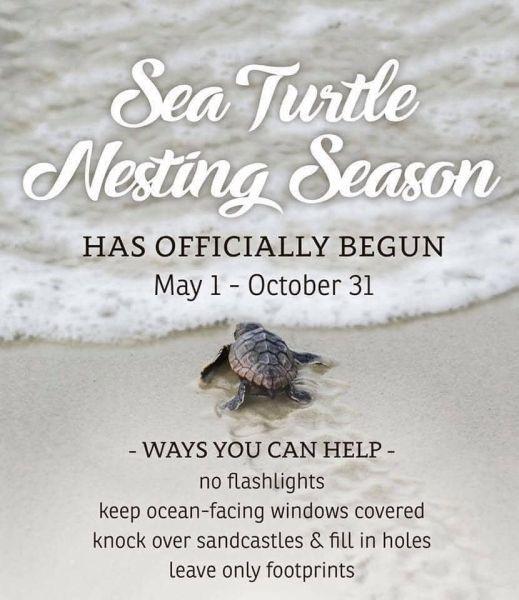
Turtle Watch Program –

Turtle Watch Program – 2024
The first nest of the 2024 season was on May 18th
Average annual number of nests is 57
Current nest count – (65) as of 08/24/24
Members of the patrol started riding the beach every morning on May 1 and will do so through October looking for signs of turtle nests.
For more information » click here
5 things to know about sea turtle nesting season along the NC coast
On May 6, Oak Island had something to celebrate: the Oak Island Sea Turtle Protection Program took to Facebook to announce its first sea turtle nest of the season — also the first nest of the year in North Carolina.
In the coming months, many female sea turtles will follow, making their way onto local beaches to lay their eggs.
Here’s what you need to know about sea turtles.
When do sea turtles come ashore?
Sea turtle nesting season occurs each year from May through September. According to a fact sheet from the North Carolina Wildlife Resources Commission, female sea turtles emerge from the ocean at night, and using their flippers, dig an 18-inch-deep hole that will serve as the nest where she will deposit 80 to 120 eggs. After laying the eggs, she covers the nest and returns to sea.
What happens to the babies?
After about a 60-day incubation period, the hatchlings emerge and make their way to the ocean. Only about one in 1,000 hatchlings will live to reproduce.
Are there different kinds of sea turtles?
Yes. There are seven species of sea turtles worldwide, and five visit the beaches of N.C. According to information from the N.C. Wildlife Resources Commission, the most common in North Carolina is the loggerhead, but one may also see leatherback, green, hawksbill, and Kemp’s ridley.
How can I help sea turtles?
The N.C. Wildlife Resources Commission’s fact sheet lists the following tips:
- Use red filters on flashlights when talking on the beach at night.
- Do not disturb nesting sea turtles.
- Turn off outside lights facing the beach front during sea turtle nesting season.
- Keep dogs on a leash.
- Reduce beach traffic around sea turtle nests.
- Properly dispose of trash.
- Be mindful of sea turtles when boating or using watercraft.
- Volunteer with the Commission, the Karen Beasley Sea Turtle Hospital, or a beach clean-up crew.
- Join a conservation organization.
- Donate to the N.C. Nongame and Endangered Wildlife Fund.
Who do I contact if I see a sea turtle on the beach?
The N.C. Sea Turtle Project works with 20 different volunteer groups. Contact information for each is available at nc-wild.org/seaturtles/contacts, or call the statewide sea turtle hotline at 252-241-7367.
Read more » click here
Upon Further Review –
 Pending sewer repairs, this abandoned Brunswick development will be revived
A zombie development in Shallotte could soon be revived. But before that happens, the town of Shallotte will have to repair the sewer system in that area.
Here’s what you need to know.
The development was once known as San Rio.
Plans for San Rio Ocean & Beach Club began in the mid-2000s, with the first lots sold in February 2007. At the time, the community, a Caribbean-themed resort on Gray Bridge Road, sought to double the town’s population. Wakefield Development Co. out of Raleigh was the original developer for the project. Plans included about 1,200 single-family homes, and 1,200 condominiums and townhomes for a total of 2,400 housing units, as well as a clubhouse, pool, and other amenities. The projected completion date was 2008.
The project was abandoned after the housing market crash.
A court-appointed real estate firm, Landtech Receiver Services LLC, completed the infrastructure for the subdivision after Wachovia Bank sued the developer. The sewer infrastructure was eventually completed, certified by the state, and conveyed to the town in April 2011.
Drapac Capital Partners purchased San Rio in 2014.
A real estate investment firm, Drapac held onto the property and began making plans to develop it once the housing market improved.
Drapac is moving forward with those plans.
According to a letter sent to Shallotte town officials by Drapac’s legal counsel, Drapac “is on the verge of finalizing a contract with a national homebuilder to purchase a portion of the project.”
Before building can begin, sewer repairs are needed.
The letter, dated July 8, 2024, stated Drapac representatives met with Shallotte officials to discuss the need for repairs to San Rio’s sewer facilities in February 2024. Tests were conducted on the system in the last week of April 2024. Notes included in the Shallotte Board of Aldermen’s July 18 workshop packet, stated during testing, “none of the runs of pipe tested met the standards for new construction with some exhibiting significant failures.”
Sewer repairs are estimated at $280,000.
Shallotte Town Administrator Mimi Gaither confirmed the town will be completing the necessary repairs. “We have made contact with the contractor doing the repairs and he is adding us to his schedule,” Gaither said in an email. No homes were constructed in the development after the infrastructure was completed, and Gaither explained it was difficult to maintain the system because the city’s access was restricted. “The issue in the past is that the community was gated and we had no access, nor were there any structures tied to a system so there was no flow on any of the pipes,” Gaither said. “We did maintain the sewer lift station weekly.” Funds for the repairs will come from the town’s sewer fund.
The development will get a new name.
Katie Fidler, director of real estate and investor relations for Drapac, confirmed San Rio will now be known as Solserra. In addition to rebranding the development, Fidler said they are working with local consultants to finalize entrance and landscape plans. She added they plan to emphasize the river, which they believe is one of the property’s “most attractive features” and “creates a massive point of difference as compared to other new home communities in the area.”
Construction could begin this fall
According to the July 8 letter, Drapac “intends to submit applications for permits for the project and aims to commence construction in October 2024.” “We are all looking forward to this being a viable and successful project for the Town,” Gaither said.
Read more » click here

Placing ‘a large bet,’ developers are bringing a Brunswick zombie development back to life
Twenty years ago, work began on a premier beach community called Ocean Isle Palms. The Coastal Companies, Mark Saunders’ development group, began lot sales in Phase One of the project in 2006. But the housing market crash brought progress to a halt. Saunders sold his last lot in 2009, and he returned Ocean Isle Palms to Bank of America in an out-of-court settlement. In 2014, Ocean Isle Palms was acquired by Drapac Capital Partners, an Australian-based real estate investment firm with a U.S. headquarters in Atlanta. For years, it remained dormant as developers waited for the market to rebound. “We placed a large bet because we believe in the future of this region of the country and specifically in Brunswick County,” Sebastian Drapac, CEO of Drapac Capital Partners, said in an email. “We were prepared to be patient and took a long-term view. We believed that robust growth was only a matter time, and wanted to create something that would be a truly great contributor to the Ocean Isle community.” When Drapac purchased the development, only three homes had been completed. Today, that number sits at six, but that will soon change. The revitalization of Ocean Isle Palms began earlier this month. With construction underway, here’s what to know about plans for the development.
Drapac has partnered with Toll Brothers for Phase One
Toll Brothers, a luxury homebuilder, works in 50 markets across 24 states, including Myrtle Beach, South Carolina. “The first builder in the project will set the tone, and we wanted a group that shared our vision and standards,” Drapac said. “Toll Brothers brings consistently high quality to everything they do, but they also tailor for local considerations.” Phase One consists of 89 single-family detached homesites. Toll Brothers is now building its model home and first inventory homes. Those are expected to be completed in early Spring 2025.
The development will retain its original name: Ocean Isle Palms
Over the years, there was some discussion about changing the name of the development, but leaders felt retaining the name was crucial. “We wanted to deliver on the original promises our predecessors made over 20 years ago,” Drapac said.
Phase One is just the beginning
At build out, the community will include about 1,100 residential units, as well as multi-family, commercial, and retail uses.
Residents can expect upgraded features and amenities
The original entrance of Ocean Isle Palms has stood for nearly 20 years, and it too will undergo a revitalization to reflect the rebirth of the community. The community’s new entrance is expected to be completed this fall. The plan will offer an upgraded amenity with an architectural design described as low country “with a modern touch.” It will include a central club building, a post office mailbox building, a pool cabana with bathrooms, and a courtyard off the parking lot. The central club building will offer a large gathering room, bathrooms, and a covered outdoor fireplace that overlooks an event lawn. Other amenities include a fitness center with a walking path around a lake and a private outdoor lawn area, eight pickleball courts and two bocce ball courts.
The commercial area will deviate from the original plan
The most significant change is the move away from a “town center” concept for the project’s commercial areas. “After speaking with the original owners, community stakeholders, and homebuilders, we have shifted those components south towards downtown Ocean Isle Beach and away from the community’s residential phases,” Drapac said. Planning is ongoing for stage one of the commercial component. More details and a formal announcement could come as early as the end of the year. “Our ultimate goal for the commercial and retail components of this project understand and deliver what the market demands,” Drapac said.
Read more » click here
Covid –

Covid Cases Are Rising Again. Here’s What to Know.
The Centers for Disease Control and Prevention says that wastewater data shows high levels of viral activity nationwide.
As new variants of the coronavirus continue to gain traction, cases appear to be rising in much of the country. Two of those variants, KP.3 and an offshoot, KP.3.1.1., account for nearly half of all cases, and data from the Centers for Disease Control and Prevention shows high levels of viral activity in wastewater nationwide.
Here’s what to know about symptoms, testing and treatment if you do fall ill:
Symptoms to watch out for
There’s no evidence that symptoms of the new dominant variants, including those collectively known as the “FLiRT” variants, are any different than other recent strains of the virus, said Aubree Gordon, an infectious disease epidemiologist at the University of Michigan. The symptoms still include sneezing, congestion, headaches, sore muscles, nausea or vomiting. Many people also report exhaustion and a general “blah” feeling. In general, the more immunity you’ve built up from vaccination or past infections, the milder your next bout with the virus is likely to be. (Though it’s possible to experience more intense symptoms with a new infection than you’ve had in past Covid cases, and your symptoms can vary from one infection to the next.) The symptoms of Covid can look similar to those caused by allergies or other infections. The best way to tell the difference is to test.
When (and how) to test
In an ideal world, experts said, people would take a Covid test as soon as they develop symptoms or learn they were exposed, and then test again a day or two later. But if you only have a limited number of at-home rapid tests, there are a few ways to maximize their usefulness: Test immediately if you have a fever and a cough, said Dr. Davey Smith, an infectious disease specialist at the University of California, San Diego. If you have other symptoms but few tests on hand, you may want to wait a few days to test, to reduce the chance of a false negative. People who are immunocompromised, older or who have underlying health issues may want to test as soon as they feel sick or learn they were exposed, so they can start taking Paxlovid to reduce the severity of the illness, said Dr. Paul Auwaerter, clinical director of the division of infectious diseases at Johns Hopkins Medicine. If you’ve had symptoms for more than three days but are still testing negative, it’s unlikely you’ll ever test positive on an at-home test, Dr. Gordon said — either because you do not have Covid, or because you are shedding amounts of the virus that are too low for a rapid test to pick up. If you’re waiting to test, you should take precautions in the meantime to minimize the potential spread of the virus, like wearing a mask in public and isolating from others, said Dr. Paul Sax, the clinical director of the division of infectious diseases at Brigham and Women’s Hospital. Before using a test, check its expiration date. If it’s past the date, you can see whether it’s still usable by going through the F.D.A. database of tests. Be mindful in the summer months about where Covid tests are stored; leaving them in extreme heat for several days may make them less accurate. Health officials have also advised against using tests made by Cue Health.
Medications to prevent and treat Covid
In March, the F.D.A. approved a new medication for highly immunocompromised people, such as those receiving stem cell or organ transplants. The drug, Pemgarda, is a monoclonal antibody infusion that can be taken as a preventive measure, before people contract the virus. People age 12 and older who have tested positive can take Paxlovid within five days of developing symptoms. The medication halts the virus from replicating in the body and lowers the risk of death for people who are more vulnerable to severe disease. There is no evidence that Paxlovid is less effective against the current leading variants than previous strains of the virus, experts said. Scientists are still debating whether Paxlovid can reduce the risk of developing long Covid. There are two other antiviral treatments that doctors use much less frequently: remdesivir, or Veklury, which is given as an IV infusion to adults and children, and molnupiravir, known as Lagevrio, which is a pill that can be used to reduce the risk of severe disease in adults. Doctors advise resting as much as possible while sick. If you’re up for it, take a lap around the block — “you should not be completely inactive,” Dr. Sax said — but don’t push yourself. “Some people like to take long walks,” Dr. Smith said. “I just stay in bed and read a book. Basically, you just suffer through it.”
Read more » click here
New coronavirus vaccines are now approved. Here’s what to know.
The mRNA coronavirus vaccines from Pfizer-BioNTech and Moderna tailored for the KP.2 variant could be available within a week.
The Food and Drug Administration approved new mRNA coronavirus vaccines Thursday, clearing the way for shots manufactured by Pfizer-BioNTech and Moderna to start hitting pharmacy shelves and doctor’s offices within a week. Health officials encourage annual vaccination against the coronavirus, similar to yearly flu shots. Everyone 6 months and older should receive a new vaccine, the Centers for Disease Control and Prevention recommends. The FDA has yet to approve an updated vaccine from Novavax, which uses a more conventional vaccine development method but has faced financial challenges. Our scientific understanding of coronavirus vaccines has evolved since they debuted in late 2020.
Here’s what to know about the new vaccines.
Why are there new vaccines?
The coronavirus keeps evolving to overcome our immune defenses, and the shield offered by vaccines weakens over time. That’s why federal health officials want people to get an annual updated coronavirus vaccine designed to target the latest variants. They approve them for release in late summer or early fall to coincide with flu shots that Americans are already used to getting. The underlying vaccine technology and manufacturing process are the same, but components change to account for how the virus morphs. The new vaccines target the KP.2 variant because most recent covid cases are caused by that strain or closely related ones. Covid is less dangerous overall than it was earlier in the pandemic because our bodies have become used to fighting the virus off and nearly everyone has some degree of immunity from receiving shots or getting sick. A new shot is meant to shore up existing defenses. “It’s an opportunity to mitigate or to reduce that risk even further rather than just relying on what happened in the past,” said Robert Hopkins Jr., medical director of the National Foundation for Infectious Diseases and a physician in Arkansas.
Who needs a new coronavirus vaccine?
The United States differs from other countries in recommending an updated coronavirus vaccine for everyone except young infants, rather than just those at heightened risk for severe disease because they are 65 or older, are moderately to severely immunocompromised or have serious medical conditions. Health officials rejected a more targeted recommendation, with some contending that it’s easier to tell everyone to get vaccinated than to try to define what makes a person high-risk. Most Americans have a risk factor for severe covid, such as being overweight or having diabetes. Critics of this approach, including Paul A. Offit, a pediatrician and director of the Vaccine Education Center at Children’s Hospital of Philadelphia, worry that it detracts from the urgency of vaccinating vulnerable people who have a harder time mounting an immune response to the coronavirus.
Do the vaccines prevent infection?
You probably know by now that vaccinated people can still get covid. But the shots do offer some protection against infection, just not the kind of protection you get from highly effective vaccines for other diseases such as measles. The 2023-2024 vaccine provided 54 percent increased protection against symptomatic covid infections, according to a CDC study of people who tested for the coronavirus at pharmacies during the first four months after that year’s shot was released. “People who get vaccinated are much less likely to get infected in the first place,” said David J. Topham, director of the University of Rochester Translational Immunology and Infectious Disease Institute. “We’d love vaccines to be perfect, but Mother Nature is pretty damn smart.” A nasal vaccine could be better at stopping infections outright by increasing immunity where they take hold, and one is being studied in a trial sponsored by the National Institutes of Health. If you really want to dodge covid, don’t rely on the vaccine alone and take other precautions such as masking or avoiding crowds. But if you want to carry on with life as normal, a new vaccine lowers your risk of getting covid — at least in the short term.
Do the vaccines help prevent transmission?
You may remember from early coverage of coronavirus vaccines that it was unclear whether shots would reduce transmission. Now, scientists say the answer is yes — even if you’re actively shedding virus. That’s because the vaccine creates antibodies that reduce the amount of virus entering your cells, limiting how much the virus can replicate and make you even sicker. When vaccination prevents symptoms such as coughing and sneezing, people expel fewer respiratory droplets carrying the virus. When it reduces the viral load in an infected person, people become less contagious. That’s why Peter Hotez, a physician and co-director of the Texas Children’s Hospital Center for Vaccine Development, said he feels more comfortable in a crowded medical conference, where attendees are probably up to date on their vaccines, than in a crowded airport. “By having so many vaccinated people, it’s decreasing the number of days you are shedding virus if you get a breakthrough infection, and it decreases the amount of virus you are shedding,” Hotez said.
How long does vaccine protection last?
CDC data shows that the effectiveness of the 2023-2024 vaccine, meant to reduce emergency room visits and hospitalizations, declined sharply more than four months after receiving it. But the risk of hospitalization still remains low for most people, which made it harder for the CDC to compare outcomes for people who received an updated shot with those who did not. The CDC usually recommends a second dose for those at greatest risk, rather than everyone. Vaccines create antibodies that target the spike protein of a virus that enters a cell, but the spike protein is often evolving to overcome them or avoid detection. Other elements of the immune response, such as killer T cells, are more durable and recognize the additional parts of the virus that are not mutating. “Once the virus gets in, [T-cells] can kill off infected cells,” Topham said. “They can slow the infection down. They can prevent it from spreading throughout the body. It shortens your disease.”
Do vaccines prevent long covid?
While the threat of acute serious respiratory covid disease has faded, developing the lingering symptoms of “long covid” remains a concern for people who have had even mild cases. The CDC says vaccination is the “best available tool” to reduce the risk of long covid in children and adults. The exact mechanism is unclear, but experts theorize that vaccines help by reducing the severity of illness, which is a major risk factor for long covid.
When is the best time to get a new coronavirus vaccine?
It depends on your circumstances, including risk factors for severe disease, when you were last infected or vaccinated, and plans for the months ahead. It’s best to talk these issues through with a doctor. If you are at high risk and have not recently been vaccinated or infected, you may want to get a shot as soon as possible while cases remain high. The summer wave has shown signs of peaking, but cases can still be elevated and take weeks to return to low levels. It’s hard to predict when a winter wave will begin. If your priority is to avoid getting sick ahead of the holidays or a major event such as an international vacation, you could get your vaccine a month ahead of the event to increase your protection. If you were recently vaccinated, the FDA advises waiting two months since your last shot to get the updated vaccine. The CDC has previously said people can wait three months after an infection to get vaccinated. Manisha Juthani, Connecticut’s public health commissioner, said people who have recently had covid could time their next vaccine several weeks before a holiday when they will be exposed to a lot of people, whether that’s Halloween, Thanksgiving or end-of-year celebrations.
Where do I find vaccines?
Coronavirus vaccines are sold as a commercial product and are no longer purchased and distributed by the federal government for free. That means they won’t be as readily accessible as they once were, but they shouldn’t be too hard to find. CVS said it expects to start administering them within days, and Walgreens said that it would start scheduling appointments to receive shots after Sept. 6 and that customers can walk in before then. Availability at doctor’s offices might take longer. Finding shots for infants and toddlers could be more difficult because many pharmacies do not administer them and not every pediatrician’s office will stock them given low demand and limited storage space. This year’s updated coronavirus vaccines are supposed to have a longer shelf life, which eases the financial pressures of stocking them. The CDC plans to relaunch its vaccine locator when the new vaccines are widely available, and similar services are offered by Moderna and Pfizer.
Are coronavirus vaccines free?
Most insurance plans are required to cover recommended vaccines under the Affordable Care Act, but some may not cover shots administered by out-of-network providers. Officials say billing code errors and failure to update systems that led to improper charges last year should mostly be resolved, but if you are still getting charged for vaccines, you or your provider should contact your insurance company or appeal to the agency that regulates your plan. The federal Bridge Access Program, which provided free coronavirus vaccines to people without health insurance, ends this month. People might be able to find other assistance through federally qualified health centers, local health departments or nonprofit groups.
Can you get your covid and flu shot together?
Public health officials encourage receiving covid and flu shots in the same visit as a way to increase vaccination rates, and say that no serious side effects associated with co-administering the vaccines have been identified. But if you are someone who will get both vaccines no matter what, it could be beneficial to space them apart. Flu shots are best administered in September or October, so it might make sense to get a flu shot first with a coronavirus vaccination later if you already had covid this summer. Coronavirus vaccine manufacturers are working on combination flu/coronavirus shots. Moderna reported promising trial results that keep it on track to go to market as early as fall 2025. Pfizer-BioNTech reported mixed results from its trials, a setback.
Read more » click here
Corrections & Amplifications –
 What to know as plans to restore this BC fishing pier inch forward
Evening walks on the pier and afternoon fishing trips are classic parts of any beach trip. This year, however, marks the second summer in a row that Holden Beach visitors and residents have missed out on those memories. The Holden Beach Fishing Pier has been closed to the public since 2022, after the town purchased the pier and pier house property for around $3.3 million – without plans in place for its future. The Holden Beach Board of Commissioners got to work assessing the pier’s existing structural issues and forming a conceptual plan to renovate the property. After approving a final site plan for the property in February 2023, new board members were elected in November 2023. In December, the board was set to act on bids received for the renovation project. Instead, the board paused the project to allow the new board members to get caught up on its status and scope.
Here’s where things stand now.
Project slowly moving forward again
Earlier this year, a public input session was held to allow the public to review plans for the pier and offer their thoughts. Following that meeting, the town’s board of commissioners is inching forward with the project once again. In April, the board approved a pier property development plan to serve as a “baseline approach” and “starting point” for the development. That plan notes the repairs to the existing structure will likely need to occur in phases as funding is available. The plan suggests those phases would be to stabilize the existing structure, complete safety repairs, complete remaining repairs and extend the pier, in that order. The adopted plan also notes that, due to cost, the pier would likely be replaced with a new wood pier, rather than a concrete pier. “Although a concrete pier is preferred, it may not be financially supportable for a small tax base like Holden Beach,” the document states. Additionally, the plan notes that funding for a pier replacement would likely require financing through a loan or bond.
What’s next?
In May, the board voted to direct staff to develop a request for proposals (RFP) to move forward with accomplishing the first few tasks outlined in the pier property development plan: Preliminary design and receiving cost estimates for the repair or replacement of the pier.
Read more » click here
 Flood history questions added to real estate disclosure form
Sometimes it’s a puzzle why people don’t ask more questions, such as, “Has the river that’s down your road ever flooded your house, the house I’m thinking of buying?” The maxim “buyer beware” is wise advice no matter where a house is situated, but it’s good to have rules in place to cover homebuyers’ backs for the things they overlook or wrongly assume. As of July 1, prospective real estate buyers in North Carolina must now be provided the required North Carolina Real Estate Commission residential disclosure form by the seller that for the first time includes questions related to a property’s flood risk. The change in the form was requested in a petition for rulemaking filed by the Southern Environmental Law Center in December 2022 on behalf of the Natural Resources Defense Council, or NRDC, the North Carolina Justice Center, MDC Inc., the North Carolina Disaster Recovery and Resiliency School, Robeson County Church and Community Center, and NC Field. “Most of those are small, local nonprofits that respond to disasters,” Brooks Rainey Pearson, senior attorney with the law center, told Coastal Review in an interview, referring to petitioners. “So, we really wanted to give a voice to the people on the ground who deal with the fallout from flooding.” Pearson said that the Real Estate Commission had quickly granted the petition at the time and agreed to add the questions proposed by petitioners. It was then delayed by mutual agreement, she said, to adjust the law to allow the commission to merely make changes in the form. That would avoid having to go through a lengthy rulemaking process. “It was a longer journey than it should have been, but not because of any pushback,” she said. “I think everyone understands that homebuyers deserve to know if the property has flooded before.” Questions about flooding that have been added to the disclosure statement include the following: Is the property located in a federal or other designated flood hazard zone? Has the property experienced damage due to flooding, water seepage or pooled water attributable to a natural event such as heavy rainfall, coastal storm surge, tidal inundation, or river overflow? Is there a current flood insurance policy covering the property? Is there a flood or Federal Emergency Management Agency elevation certificate for the property? Has (the property owner) ever filed a claim for flood damage to the property with any insurance provider, including the National Flood Insurance Program? The form also notes that the requirement to obtain flood insurance passes down to all future owners for those properties that have received disaster assistance. Joel Scata, senior attorney with the NRDC, a national environmental nonprofit organization that is one of the petitioners, said that in the past, the only flood information that had to be disclosed to homebuyers in North Carolina was whether the property was in a floodplain. “Now with the changes, a buyer is going to have access to much more detailed information,” he told Coastal Review. According to state law, residential property owners are required to complete the disclosure statement and provide it to a buyer before an offer is made to purchase the property. New construction or never-occupied properties are exempted. Every question must be answered with “Y,” “N,” “NR” or “NA” for “Yes,” “No,” “No Representation,” and “Not Applicable,” respectively. Despite stern language in the form about requirements, there is enough gray area to give pause to anyone with insight into human failings. “An owner is not required to disclose any of the material facts that have a NR option, even if they have knowledge of them,” the statement says. Also: “If an owner selects NR, it could mean that the owner (1) has knowledge of an issue and chooses not to disclose it; or (2) simply does not know.” The form does warn that failure to disclose hidden defects “may” result in civil liability. It also assures that if an owner selects “No,” it means that the owner is not aware of any problem. But if “the owner knows there is a problem or that the owner’s answer is not correct, the owner may be liable for making an intentional misstatement.” If an owner selects NA, it means the property does not contain that particular item or feature. Scata said that he believes that whatever remedies are available for enforcement are strictly civil, and do not include criminal charges in the case of fraud or misrepresentation. “A buyer could file a civil suit, claim that the seller intentionally misled the buyer, make a fraud claim,” he said. But damages and other penalties would depend on the impact of what wasn’t disclosed, he added. A buyer should take any “NR” answer as a cue to ask the owner about what they don’t want to disclose, Scata said, adding “it’s a good indication that something is wrong with the property.” That choice could not be removed from the form unless it was done through a change in the legislation, he said. “The buyer always has the right to go back and explicitly ask the seller the question,” he said. And don’t just push the question with the buyer, he said, but also go talk to neighbors about the situation with flooding episodes in the neighborhood. Also, real estate brokers by law have a duty to disclose what they know, or reasonably should know, regardless of the seller’s response. “So, if a seller says something like ‘No, there’s never been (flooding) on the property,’” Scata said, “but the Realtor knows that’s not true, there’s a duty on them to disclose. And they can be liable if they are complicit in that fraud.” In that instance of potential fraud by a broker, the buyer can file a complaint with the Real Estate Commission. According to an NRDC press release, homes in North Carolina with prior flood losses would be expected to average an annual loss of $1,211, compared to $61 for the average home. In 2021, there were 13,237 homes purchased that were estimated to have been previously flooded. The expected annual flood damage totals for those homes were estimated at about $16 million. With climate change causing more intense rain and stronger storms, flooding is only going to become more of an issue, Pearson said. “Before when you only had to disclose if the house was in a floodplain, well, that’s no longer a good indicator of whether your house might flood,” she said. “The best indicator of whether your house might flood is whether it’s flooded before. And so, we think, just for the sake of transparency, people deserve to know that. But they also deserve to know that because — I believe it’s called behavioral economics — when people have more information, they’ll make different and better decisions.”
Read more » click here
Odds & Ends –
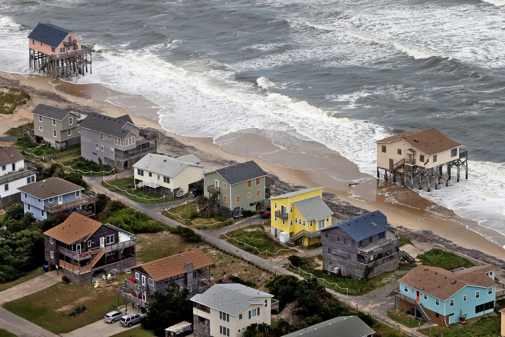
We Need to Decide Which Beaches to Save — and Which Ones to Abandon
Last December a surprise storm passed through Florida’s Pinellas County, ripping away beaches and wiping out half of the sand dunes from St. Petersburg to Clearwater. The damage was extensive, and all the more painful because the county had just spent about $26 million hauling in sand to build up the dunes after a hurricane had pummeled them in August. But this turn of events is far from unusual. Beach communities around the world are spending staggering sums replacing sand as big storms and rising seas wash it away. What used to be a maintenance task every 10 years or so is now often an annual event. For many communities, engineering the beach is worth the hefty price tag to protect properties and tourism. But as climate change hastens beach erosion, trucking or shipping huge quantities of sand to replenish beaches is likely to become economically untenable and logistically impractical. Policymakers may soon have to make painful decisions about which shores and structures to save. This doesn’t necessarily spell disaster for beach lovers. Beaches were intended to move around, and they’re better off when they do. Unlike other effects of climate change that look bleaker the further into the future you look, migrating beaches could ultimately make America’s coasts healthier by providing coral reefs and wildlife affected by sand replenishment with the habitats they need to thrive. Beachfront communities have had to maintain the sand on their shorelines ever since beaches became the holiday ideal in the early 20th century. By the mid-1930s waterfront construction in Coney Island, N.Y., Waikiki, Hawaii, and Atlantic City, N.J., had eroded beaches so much that they all had received their first infusions of sand. The federal government became more involved in the effort in the middle of the 20th century, when protecting American shores from natural disaster became part of the mandate of the Army Corps of Engineers. The agency typically picks up more than half the tab for local beach replenishment projects, while the Federal Emergency Management Agency often steps in when beaches are destroyed by hurricanes. Now more than ever, beach communities rely on this support to keep attracting the tourists who patronize beachfront resorts, vacation homes and rental properties. In the United States alone, beach tourists generate $36 billion in taxes annually. So, it makes sense that the government spent an estimated $8.2 billion on beach replenishment this century alone, compared to just over $3.6 billion over the entire 20th century. Beaches will only require more nourishment as worsening storms wash them away, sea level rise makes it harder to keep sand in place, excessive groundwater extraction causes land to sink and the rivers that once deposited sand on the coast dry up. Already beaches near San Diego and San Clemente, Calif., are shrinking by an average of 4.75 feet per year. Without them, nothing separates the fury of the ocean from the homes, resorts and other buildings that dot the shore. Even finding sand has grown more difficult; many offshore reserves are already depleted, forcing dredging vessels to venture further offshore to find sand and dig it up from the ocean floor. In some places sand has to be transported by the truckload from inland at considerable extra cost — or even purchased from other countries. The Jewel Grande resort in Montego Bay, Jamaica, for example, imported sand all the way from the Bahamas to build up its beach before it opened for business in 2017. Beach towns are already competing with companies that use sand to manufacture not only concrete, glass, and asphalt but also cellphones, semiconductors, and microchips. Global demand for sand tripled in the first two decades of this millennium. Resulting competition has led to so-called sand mafias mining it illegally in many countries, from Morocco to Indonesia, and pushing up the price around the world. For many U.S. communities whose economies depend on beach tourism, spending tax dollars on beach replenishment may be worth it for now, but the economics are becoming less favorable every year. In Southern California the amount of sand required to replenish beaches is likely to triple by 2050, and the cost could quintuple, according to a recent study. Many swaths of the Jersey Shore already require replenishment every year or two, and if the sea there rises more than a foot over the next 30 years, as the National Oceanic and Atmospheric Administration has predicted, the need will only grow. Soon there will be no way to keep up. Some coastal communities will eventually stop rebuilding their beaches, either abruptly or through what’s known as managed retreat, a coordinated, gradual move away from the shore that avoids shocks to property owners and residents. In these cases, the funds currently being siphoned off to shore up beaches could be redirected to more temporary buildings like modular homes or tents that can be relocated easily. The funds could also go toward government programs that buy back property, especially from homeowners, who may relocate or rent their homes from the government while it remains feasible. Managed retreat discourages new development, as opposed to beach replenishment, which encourages it. Of course, beaches will disappear. But they may pop up elsewhere, and this is how today’s beach erosion could benefit shorelines tomorrow. While nourishment is rooted in our insistence that beaches stay in one place, in truth, beaches were never the constants we imagine them to be. Left to their own devices, they would simply shift, even as sea levels rise. Some would drift down or up the shore, or shrink and then widen again as the power of wind, waves and tides guide sand in different directions. Others would move inland. The lucky ones would actually expand. This kind of migration is natural, and even ecologically healthy, allowing beaches to support the birds, fish and coral reefs that depend on them. In some places, this is already happening. Just south of Los Angeles, Huntington Beach is getting wider every year. In the Netherlands, Schiermonnikoog Island easily handles 300,000 visitors per year while its beach continually widens. Undeveloped barrier islands off the coast of Georgia are holding up just fine, as they are allowed to ebb, flow, and adapt to changing natural conditions. Researchers who studied 184 relatively untouched islands in the Maldives found that while 42 percent were eroding, 39 percent were relatively stable and 20 percent were growing. We can’t predict how any given beach will behave when left alone, and we don’t know exactly what shape new shorelines will take. But ending nourishment does not mean saying goodbye to enjoying a day in the sand. If we get out of the way, beaches will endure.
Read more » click here
This and That –
 Coastal counties see continued strength in visitor spending
Dare, Brunswick, New Hanover, Carteret, Currituck, and Onslow are the coastal counties to break into the Top 20 out of 100 for visitor spending in 2023. Following a record-breaking increase of 15% in 2022, spending statewide rose 6.9% to $35.6 billion in 2023, setting another record year in visitor spending, according to data the North Carolina Department of Commerce released Tuesday. The total spending is the amount spent on lodging, including second home spending, food and beverage, recreation, retail, and transportation, and both ground and air transportation added together. Mecklenburg County topped the list with $5.85 billion in total visitor spending, up 9.6% since last year. Though Camden had an 11.3% increase between 2022 and 2023 with a total spending of $4 million, the third highest increase of 100 counties, the county was at the bottom of the list for total spending. State officials noted that last year, 98 of the state’s 100 counties saw increases in spending compared with 2022. Orange, Wake, Camden, and Warren counties, in that order, led the state’s 6.9% growth in visitor spending. Dare ranked 10 in growth rate at 8.8%. The two counties that had a decrease in spending are Alexander at -3.4% and Cleveland at -1.6%. “It’s great to see increasing numbers of people continue to flock to North Carolina to see all we have to offer,” Gov. Roy Cooper said in the press release from his office. “Visitors are investing record amounts of money bolstering our booming tourism industry, and that brings good jobs and income to North Carolina businesses and families.” The preliminary findings from an annual study commissioned by VisitNC, a unit of the Economic Development Partnership of North Carolina, reflect the economic impact of tourism on local economies across the state. The visitor spending study, commissioned by Visit NC and conducted by Tourism Economics, provides preliminary estimates of domestic and international traveler expenditures as well as employment, payroll income, and state and local tax revenues directly generated by these expenditures. The statistical model draws on detailed data from Visit NC as well as data derived from federal and state government sources, nationally known private and non-profit travel organizations, and other travel industry sources.
Coastal counties by rank out of the 100 counties, total visitor spending, and growth rate:
- Dare: $2.15 billion, 8.8%
- Brunswick: $1.17 billion, 7.5%
- New Hanover $1.12 billion, 5.9%
- Carteret: $732.29, 5.3%
- Currituck: $573.35 million, 4.3%
- Onslow $412.12 million, 8.5%
- Pender $199.12 million, 5%
- Craven: $178.11 million, 4.4%
- Beaufort: $142.48 million 5.9%
- Pasquotank: $90.21 million, 6.7%
- Hyde: $61.87 million, 6.1%
- Pamlico $37.76, million, 3.7%
- Hertford: $31.21 million, 6.7%
- Chowan: $30.11 million, 4.8%
- Bertie: $24.47 million, 4.5%
- Perquimans $20.43 million, 3.1%
- Washington $18.41 million, 3.3%
- Gates: $9.89 million, 1%
- Tyrrell $6.94 million, 3.1%
- Camden: $4 million, 11.3%
Other tourism facts for 2023 provided by the state include the following:
- Total spending by domestic and international visitors reached $35.6 billion, a 6.9% increase over 2022 expenditures.
- Direct tourism employment increased 4.8% to 227,200.
- Direct tourism payroll increased 6.6% to nearly $9.3 billion.
- Visitors generated nearly $4.5 billion in federal, state, and local taxes, a 5.8% increase from 2022. State tax receipts from visitor spending rose 5.6% to $1.3 billion.
- Local tax receipts grew 5.4% to $1.2 billion.
- Visitors spend more than $97 million per day, adding about $3.7 million in state taxes and $3.4 million in local taxes.
- Each household saved $518 on average in state and local taxes as a direct result of visitor spending in the state. Savings per capita averaged $239.
Full tables can be accessed at https://partners.visitnc.com/economic-impact-studies.
Read more » click here

The Wilmington area is buzzing with mosquitoes. Here’s why and what to do.
Tropical Storm Debby’s deluges flooded parts of the Wilmington area that hadn’t seen water in years, turning them into new mosquito breeding grounds.
The social media comments about the Bailey Zimmerman show at Wilmington’s Live Oak Bank Pavilion last weekend were overwhelmingly positive. But a lot of the buzz about the rising country music star’s concert was also about another attendee, and this one wasn’t as welcome as the Illinois-born crooner: Mosquitoes. Many concertgoers lamented about the swarming bloodsuckers that have made venturing outside along the Cape Fear River or near Greenfield Lake a somewhat miserable experience in recent days. Jeff Suggs, head of New Hanover County’s mosquito control program, said Eagles Island across from downtown Wilmington is largely to blame for the recent invasion. “They are swarming and we’re trying to knock them down this week,” he said, mentioning the stepped-up efforts his department and Brunswick County − which manages Eagles Island − are conducting. “But when those floodwater mosquitoes come off, they come off in astronomical numbers.” Thanks to Tropical Storm Debby, the Port City isn’t alone in dealing with swarms of the biting insects even though the soggy weather system left Southeastern North Carolina nearly two weeks ago.
Why are the bugs so bad?
Nowhere is going to see 15 inches or more of rain in just a few days without impacts, and the Cape Fear region is no different. Flooding, which is still impacting some parts of the region, sent water into areas that had largely been dry for months or even years. “Some areas that haven’t had water for years have it now,” Suggs said, adding that some floodwater mosquito eggs that have laid dormant in the soil for years since as far back as 2018’s Hurricane Florence − the last big flooding event for much of the Wilmington area − are likely now getting activated. And thanks to climate change, the local biting season could be about to get worse for longer as spring and fall temperatures increase as more and more heat-trapping gasses are pumped into the atmosphere, allowing mosquitoes to have a longer season to breed, bite, and spread viruses. A 2023 analysis by Climate Central found Wilmington had 11 more “mosquito days” − for a total of 221 − in 2022 compared to 1979. The nonprofit climate communications group defined “mosquito days” as having an average relative humidity of 42% or higher and daily minimum and maximum temperatures between 50 to 95 degrees. While the Port City’s numbers are trending in the wrong direction, it was better than what researchers found in Raleigh-Durham (+27 days), Greenville (+22 day) and Asheville (+22 days). Southeastern North Carolina is home to more than 40 species of mosquitoes, several of which are non-native but have been able to adapt to the region’s climate. That increase in species, their range and potentially numbers is expected to continue as the weather gets warmer and more humid.
Is the surge in mosquitoes a health concern?
From a human health perspective, officials are more worried about the viruses the mosquitoes can carry more than the biting and general annoyance they can bring to people while outside. Those health risks include the Zika virus, dengue fever, Chikungunya virus, Eastern Equine Encephalitis and West Nile virus. Suggs said his department is able to do a lot of its own virus testing, and so far there haven’t been any positive pulls found in trapped mosquitoes so far. Ironically, the region was largely having a good mosquito year prior to Debby largely thanks to the drought that started in spring and continued up until mid-July. “Some traps where we would regularly see 60 mosquitoes a night, we were only seeing four,” Suggs said. “And then Debby came along. But as far as them being a nuisance before that, we were having a good summer.”
What’s being done about it?
Suggs said his crews have stepped up their spraying efforts, doubling back to hit areas − like downtown − that are especially buzzing with the bugs. Officials also treated some areas before Debby hit with larvicide to pre-empt them being used as mosquito hatcheries. In Brunswick County, county spokesperson Meagan Kascsak said crews also have stepped up their spraying efforts post-Debby to try and get ahead of the swarms. But Suggs said residents might just been to grin and bear it for a few weeks until the mosquitoes live out their mercifully short life cycle. “It’s nature,” he said. “We can only battle them so hard.”
How can I protect myself?
Experts say people can help limit their exposure to mosquitoes by removing pools or containers of stagnant water, including in their gutters, from their yards, since most mosquito species don’t generally venture more than a few hundred meters from their homes when hunting. Avoiding activities at dusk and dawn and wearing long clothing also can help limit potential exposures.
Sources and info
Several government agencies offer information on how to make your home less attractive to mosquitoes and the potential threats posed by the bloodsucking insects. Local mosquito control offices also have information about local spraying schedules and how to request additional treatments.
- U.S. Centers for Disease Control and Prevention (CDC):
https://www.cdc.gov/mosquitoes/index.html - N.C. Department of Health and Human Services (DHHS):
https://www.ncdhhs.gov/after-storm-mosquitoes - New Hanover County Mosquito Control:
https://www.nhcgov.com/674/Mosquito-Control / 910-798-6713 - Brunswick County Mosquito Control:
https://www.brunswickcountync.gov/349/Mosquito-Control / 910-253-2515 - Pender County Mosquito Control Division:
https://pendercountync.gov/228/Mosquito-Control-Division / 910-259-1230
Read more » click here
THB Mosquito Control
Current EPA protocol is that spraying is complaint driven
The Town is unable to just spray as they had in the past
. 1) Complaint based
. 2) Citizen request
. 3) Proactively monitor hot spots
They recommend that you get rid of any standing water on your property that you can
Urged everyone to call Town Hall if they have mosquito issues so that they can spray
Factoid That May Interest Only Me –
Living along the NC coast is increasingly risky.
So why are property values still rising?
A new economic model suggests that tax incentives and federal subsidies help fuel coastal property price increases despite growing climate change risks, like sea-level rise
Anyone who has dreamed of owning a property at the beach knows that it’s a goal shared by many. Couple in the growing popularity of coastal living in general − the Wilmington-area’s population jumped from 200,000 in 1990 to more than 450,000 in 2020 − and home ownership is increasingly becoming the privilege of the rich and the few. According to a report by online research publisher Stacker using real estate data from Zillow, Wrightsville Beach has seen a nearly 74% increase in property values over the past five years, with the typical home value now pushing an eyewatering $1.46 million. That makes it the most expensive town in the state, with Bald Head Island a close second with a 76% increase in values in the past five years increasing the average home on the Brunswick County island to $1.3 million. Of the top ten priciest locales in North Carolina, six are coastal communities. But are government actions helping bake in the advantages that high-income property owners have in reaching the coastal dream even as evidence mounts that the risk from climate change and sea-level rise is making living along the ocean an increasingly risky proposition? That’s a question North Carolina researchers attempted to tackle in a recent study published in Nature Communications that looked at how economic incentives and subsidies are impacting coastal property markets. Dr. Dylan McNamara, professor of physics and physical oceanography at the University of North Carolina Wilmington and one of the study’s authors, said the changes occurring along much of the U.S. coast can’t be viewed as just uniquely physical or uniquely economic. “They are linked, a coupled human environmental system where the environment is impacting humans and humans are impacting the environment,” he said. Dr. Martin Smith, an environmental economics professor at Duke University, and McNamara created a new economic model called the Coastal Home Ownership Model (C-HOM) to analyze the long-term evolution of coastal real estate markets. Smith said government actions to protect and enhance coastal communities from environmental risks, such as sea-level rise and stronger and more frequent hurricanes, helps support and boost property values. “What it signals to the market is that this is a fine place to further invest,” he said. Paradoxically, as property values increase and coastal communities become more wealthy, it becomes easier for officials to justify additional and more expensive projects to maintain that economic value in these increasingly vulnerable areas. “We’re shielding these markets from the underlying risks they face, and hence propping up these markets,” McNamara said.
Subsidized sand
Take the history and role of beach nourishment projects, for example. When Congress decided to get the federal government involved in the beach-building business nearly six decades ago, the thinking was oceanfront communities would only require sand roughly once every 10 years or so. The cost of these federal projects would be split between Washington and local governments, with the federal government picking up most of the tab and the state and/or local communities paying the rest. As erosion has increased thanks to sea-level rise and more frequent storms, that’s now been reduced to every couple years − a timeline that doesn’t include federal emergency beach-building projects after major storms. And as more towns see their beaches washing away and confront the high costs of nourishment, thanks to sand scarcity and increased environmental regulations, there is a growing chorus of communities who want their own federal nourishment project. Currently, New Hanover County’s three beach towns and Ocean Isle Beach in Brunswick County are the only North Carolina communities that are guaranteed a periodic injection of fresh sand largely funded by the federal government. Critics say beach nourishment projects funded by federal taxpayers are bad long-term investments that literally just wash away, only benefit rich oceanfront property owners, and have to be repeated every few years to be truly effective. Backers claim beach-building projects are vital to keeping coastal economies running, protecting oceanfront properties and vital infrastructure, and helping communities hit hard by hurricanes rebound.
Analyzing the trade-offs
Both McNamara and Smith said there’s no doubt taxpayer-subsidized projects like beach nourishments have short-term and even medium-term economic benefits. But the cost of defending the shoreline, while propping up property values, is itself increasing. That means more of those costs need to be shouldered by state and local governments if they have the necessary political will and the deep pockets. McNamara and Smith also warn that those rising costs, which beach towns will increasingly have to pass on to their residents or private property owners will have to fund themselves, coupled with surging property values will likely increase the gentrification of many coastal communities − a process that’s already occurring in many beach towns. Some North Carolina coastal communities are already facing these tough decisions. In 2022, North Topsail Beach pulled out of a federal beach nourishment project with Surf City over cost concerns, and Dare County has told residents of Rodanthe, an unincorporated community on Hatteras Island that has some of the highest erosion rates along the entire N.C. coast, that it simply can’t afford to nourish the village’s eroding beach that has already swallowed several homes. Increasing home and flood insurance premiums also are heaping additional pressures on many coastal residents. With the impacts from climate change expected to get worse in the coming decades, the researchers said change is coming. How officials manage the long-term economic adjustments required to adapt to an evolving environment so that they don’t all hit at once could be key to sustaining some of these coastal communities. ”As markets begin to sniff out those impacts, which is to say as the risk begins to increase, values will begin to go down,” McNamara said. “So, the question is when do we see that trajectory, and what path will it take.” Potential options the researchers suggest include managed retreat, possibly including the idea of a purchase and buy-back program so owners can continue to “rent” their homes until they have to move, and building smaller, movable structures that can more readily react to the rising ocean levels instead of the McMansions that are increasingly proliferating along the coast. “There are certainly trade-offs,” Smith said, “but we want people to have a clear view of what those trade-offs are.”
Read more » click here
Beach Strand –

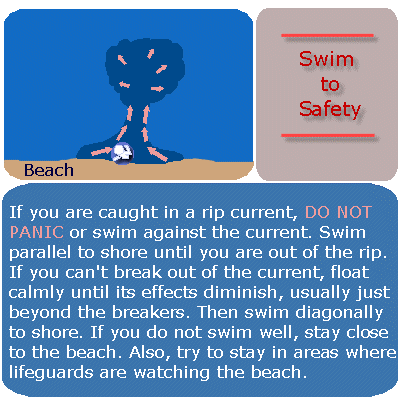 Forecasters, lifeguards warn: Rip currents are deadly
Not unlike getting a vehicle tune-up before a risky cross-country trip, emergency responders and weather officials are reinforcing the messaging about ocean safety as hundreds of thousands of beach lovers head to the coast for the July Fourth holiday. “In the Carolinas, rip currents are our biggest killer,” said Erik Heden, warning coordination meteorologist with the National Weather Service’s Newport/Morehead City office. Heden was speaking Thursday at the 2024 Eastern Carolinas Beach Hazards and Rip Currents Integrated Warning Team event held at Jennette’s Pier. In addition to representatives from the National Weather Service, the team included input from local emergency and public safety officials and ocean rescue personnel, as well as government communication representatives to discuss current and future beach safety issues. Since 2000, there have been 184 victims of rip current drownings in the Carolinas, 49% of whom were out-of-state residents, Heden said. Of them, 86% were male, most of them aged 41 to 50. Female victims were mostly between 31 and 40 years old. “That’s four times the number of deaths from tornados, floods and wind combined,” Heden said. The data didn’t include those who were caught in rips, but their deaths were attributed to an associated cause such as a heart attack, he added. About 100 fatalities annually in the U.S. are estimated from rip currents, and as much as 80% of all ocean rescues are rip current-related. But fortunately, there has been a lot of progress made in preventing the loss of life from rips, mostly by educating the public about the hazard, and by providing better tools to avoid the risk. To stretch the road trip metaphor, staying safe can come down to commonsense measures such as checking road conditions and the weather report. Going to the ocean should be no different. “Before we even get to the beach,” Heden said, “let’s talk about knowing some things.” Those “things” include questions such as: Where are lifeguarded beaches? What are conditions that day at the beach location? Do you need a floatation device? What is the rip current risk? Awareness can not only prevent drowning, but it can also mean not having to be saved by lifeguards. Recently, numerous news outlets reported that more than 150 beachgoers in New Hanover and Carteret counties and more than 80 at Carolina Beach alone were rescued from rip currents, which are channels of water typically formed at breaks in sand bars and that flow away from the beach. People can sign up for alerts on beach conditions and daily rip current risks at North Carolina beaches from the National Weather Service. Dare County also offers a service that provides alerts from Dare County lifeguards about local beaches. Beachgoers also need to know about other hazards that include lightning, another big weather-related killer. Leave the beach immediately if you hear thunder. Lightning strikes can happen when a storm is as far as 10 miles away. Several strikes on the Outer Banks have happened when people were in the parking lot after exiting the beach. Other risks ocean swimmers need to be aware of are shore break, that is, when a wave breaks forcefully in shallow water, and rogue waves that seemingly come out of nowhere and can throw a person into the surf. “They can be deceptive, and you don’t see them coming,” Hatteras Island Rescue Squad Supervisor Molly Greenwood said at a press briefing. “Never turn your back to the ocean.” Even something as seemingly harmless as walking on the sand is dangerous when temperatures are high, and the sun is strong. Ben Abe with Chicamacomico Banks Volunteer Fire Department water rescue said that one man suffered second-degree burns on the bottom of his feet from going barefoot on the beach and had to be transported to the hospital. In recent years, the National Weather Service has produced numerous informational videos and pamphlets about beach safety that are available through its website, including the award-winning “Play it Safe” series. The public information is geared to a fifth-grade education level, so it’s readily accessible for school-aged children, Heden said. “We do a tremendous amount of public education,” he added. Two important new infographics are focused on hazards that are related to rip currents but had often been overlooked in risk assessments. One provides advice to bystanders who want to help swimmers caught in a rip current or are struggling in the ocean, with a warning to call for help but not to enter the ocean without a floatation device. According to the weather service, nearly 30% of rip current drownings in the Carolinas since 2011 were bystanders trying to save another person. The other graphic illustrates the risk that far-offshore tropical storms create by intensifying the strength of currents, with a West Coast and East Coast version. Several videos and graphics are also offered in Spanish. The weather service beach forecast webpage will soon be transformed into a GIS-based platform, compatible with mobile devices, said Melinda Bailey, NWS National Marine Services program manager, who attended the event remotely. Web-based users will not have to download any proprietary software to access the platform, which is expected to be implemented by fall 2024, she added. “It’s a long time coming but it’s very exciting,” Bailey said. Bailey said the weather service has been working on predictive artificial intelligence models to improve accuracy of information on rip currents and other forecasting. Heden said that he looks forward to continued progress in beach safety through advancement in communication and predictive modeling tools, including cutting edge technology. “I’m intrigued by the virtual reality stuff,” he said. “It would be interesting to incorporate that.”
Learn more: National Weather Service Rip current brochure
https://coastalreview.org/wp-content/uploads/2024/06/rip_brochure_51419b.pdf
Read more » click here

These counties have the most shark attacks on North Carolina’s coast.
With tourists flocking to North Carolina beaches for the start of the summer, people will be diving into the home of many ocean creatures and that includes one of the most dangerous — sharks. The Florida Museum has an International Shark File as Florida is the top state for shark attacks in the United States. The file logs shark attacks all across the world and includes top attack states in the country, one of those states being North Carolina, which came in at No. 5.
Types of attacks
The International Shark File uses a number of different categorizations to describe attacks, including unprovoked bites, provoked bites, boat bites, scavenge, public aquaria, no assignment could be made and not confirmed.
Here are the worldwide statistics for shark attacks in 2023.
- Unprovoked bites: 69
- Provoked bites: 22
- Boat bites: 9
- Scavenge: 2 (post-mortem bites)
- Public Aquaria: 1
- No assignment could be made: 1
- Not confirmed: 16
How does North Carolina rank?
Out of all the states in the country, North Carolina ranks No. 5 for shark attacks behind its sister state South Carolina. North Carolina has had 80 confirmed unprovoked shark attacks since 1837. South Carolina has had 118, California has had 138, Hawaii has had 195 and Florida came in first at a whopping 928 unprovoked attacks.
County breakdown
Two of the Cape Fear region’s counties lead the numbers for confirmed unprovoked shark attacks since 1935 in North Carolina. Brunswick County tops the list with 18 attacks, followed by New Hanover County with 15 attacks.
Here’s the full list:
- Brunswick County: 18
- New Hanover County: 15
- Carteret County: 14
- Dare County: 11
- Onslow County: 10
- Hyde County: 4
- Currituck County: 3
- Pender County: 2
From 2012-2021, there have been a total of 31 bites in the state, but none of them have been fatal, according to the International Shark File.
What are the odds?
According to the Florida Museum, more people in the water has a strong correlation to the amount of attacks, which could point to why Brunswick County is at the top of the list for attacks on North Carolina’s coast as it is the fastest-growing county in the state. New Hanover County and Brunswick County are also part of the Wilmington Metro Area, which ranked No. 9 in the U.S. Census Bureau’s Top 10 U.S. Metro Areas from July 1, 2022, to July 1, 2023. But, although the chances are not zero, a person has a far greater chance of drowning than they do death by shark attack, according to the Florida Museum.
How to reduce the risk
Here are some tips provided by the Florida Museum to help keep yourself and others safe in the water this summer.
- Swim with a buddy.
- Stay close to shore.
- Don’t swim at dawn or dusk.
- Don’t swim around schools of fish or where people are fishing.
- Avoid wearing jewelry.
- Avoid excess splashing.
What to do when a shark is near
- Maintain eye contact with the shark.
- Slowly move away, and if possible, exit the water.
If the shark tries to bite you
- Hit shark in the eyes and gills —
Sensitive areas that can be hurt regardless of personal strength. - Hit the shark on the snout and push away —
Water-resistance weakens your punch.
- Hit shark in the eyes and gills —
Read more » click here
As weather warms, nesting shorebirds and sea turtles join people heading to NC’s beaches
With people flocking to the coast, officials hope education and outreach can help efforts to share the sand with nesting birds and sea turtles.
As the weather warms, sun-seeking tourists aren’t the only ones drawn to North Carolina’s rich necklace of barrier islands along its 320 miles of coastline. If you’re visiting the beach this summer, there’s a good chance you’ll see wildlife mixed in with visitors and the occasional resident. But sharing valuable beach real estate with nesting shorebirds and sea turtles can be challenging. Mix in the loss of habitat on many islands to development, the growing risk from climate change, and the increased threat of disturbance tied to human activities, dogs and even predators and the odds are often stacked against the native fauna. The eggs and chicks of nesting shorebirds often blend in perfectly with the sand, making it easy for people or pets to accidentally step on them. Getting close to the nests or babies can be just as bad, scaring the parents off and leaving the eggs and chicks at the mercy of predators and the summer heat. That’s where groups like the N.C. Wildlife Resources Commission and Audubon North Carolina come in to help level the playing field. Hundreds of signs ring the state’s coastal nesting sanctuaries from Currituck Sound in the north to Sunset Beach in the south, warning visitors to respect nesting areas. In some locations, including Wrightsville Beach, volunteers help reinforce that message. Hope Sutton, eastern wildlife diversity supervisor with the wildlife commission, said education and outreach efforts are some of the most powerful tools officials have to raise awareness about the birds’ requirements. “It’s a critical component, whether its students at Wrightsville Beach Elementary making cute signs to warn beachgoers to stay out of the refuge or adults learning about these birds through one of our outreach activities,” she said. “Our behavior patterns can really impact the chance of success many of these birds species have.” The helping hand comes as regulators worry about the future of some of the state’s shorebirds. North Carolina’s 2023 waterbird survey, which is conducted every three years and is a collaborative effort among government agencies and environmental groups, showed substantial dips in the numbers of many nesting shorebirds. Among wading birds, that list included cattle egrets, tricolored heron, little blue herons, snowy egrets and glossy ibis. Beach-nesting species showing substantial declines included the common tern, gull-billed tern, and Caspian tern. Another species that is in trouble is the black skimmer, with North Carolina’s population decreasing by half since 1999. Because skimmers nest directly on the open sand, they are especially vulnerable to disturbance and loss of nesting sites. But the survey wasn’t all bad news. Least tern numbers were found to be increasing, with many of the nests found on the beaches at the south end of Wrightsville Beach and on Lea-Hutaff Island in Pender County. Brown pelicans also are doing well, with 5,227 nests reported in 2023, well above the 15-year average of about 4,000 nests. Many of the shorebirds holding their own nest on spoil islands, like those in the Cape Fear River or Intracoastal Waterway, or on sections of protected natural areas like Masonboro Island that are hard to access. But climate change is an unknown variable that could add to the pressure many species face. On low-lying manmade dredge islands, for example, rising seas and stronger tropical storms tied to warming temperatures could increase erosion and over wash threats. “And the competition for sand is already tough and is likely to get worse in the coming decades,” Sutton said, referring to the limited nearshore sand resources and many coastal towns now seeking nourishment projects to boost their eroding beaches. A warming climate also could prompt some birds to nest sooner. Lindsay Addison, a coastal biologist with Audubon North Carolina, said learning to share the beach and knowing when to back away, such as when a shorebird starts acting irritated, can go a long way to help. “Anyone who has lived down here for a while knows that there are more and more people now, and sometimes it’s really hard to go anywhere along the coast and not run into a lot of people,” she said. “The birds also are experiencing that, and there are a lot of opportunities for people to disturb them and impact their survival. “But if we just keep our distance and take some other steps, like keeping our dogs on a leash during certain times, it can make a really huge difference.” Shorebird nesting season runs from March through mid-September.
Turtle time
Shorebirds aren’t the only ones looking to nest on area beaches. Peak sea turtle nesting season begins May 1 and continues through the end of October. Most local beaches are monitored daily during sea turtle nesting season to look for evidence of nests, which are then monitored and protected if needed during the roughly two-month incubation period. While sea turtle nesting numbers have been showing increases in recent years, regulators and environmentalists warn the marine reptiles still face many threats − especially during the decades they navigate the oceans before females return to their birth beach to nest. While on the beach, threats dangers include holes dug in the sand and left by beachgoers, which can trap hatchlings after they emerge from the nest, and bright lights from homes and businesses that can distract nesting mothers and hatchlings and lead them away from the ocean.
Sharing the beach
Tips from the N.C. Wildlife Resources Commission on how to share the beach with nesting wildlife this summer:
- Respect the boundaries of the roped-off nesting areas
- Keep dogs on a leash
- Follow beach driving regulations
- Throw away trash properly, including fishing line and kite strings
- Don’t feed sea gulls or least terns
- Don’t fly drones or kites near nesting sites
Read more » click here
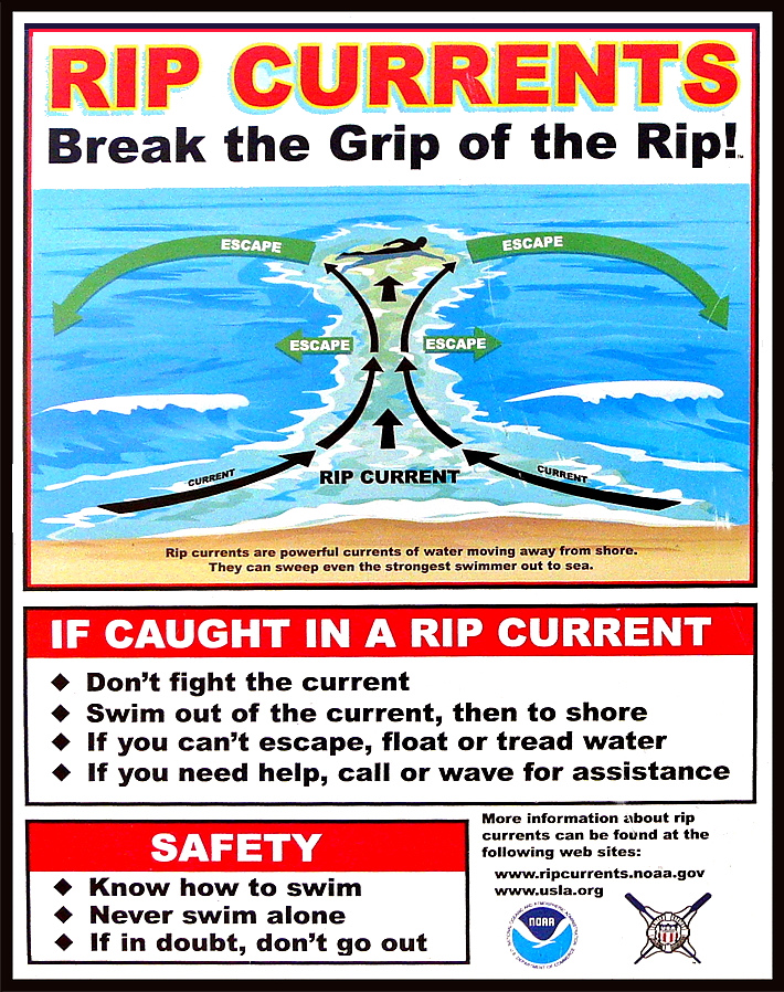
Most rip current deaths are preventable. Yet people keep drowning.
Beach-safety experts are frustrated by the mounting fatalities despite awareness campaigns and improved forecasts
Rip-current deaths in the United States are running ahead of last year’s pace — at least 29 since the beginning of the year — with peak beach season yet to come. Experts are warning the public to be aware of this largely hidden hazard ahead of Memorial Day weekend, traditionally one of the busiest beach weekends of the year. The risk of dangerous rip currents is expected to be particularly high this weekend along portions of the Southeast coast where a storm could produce heavy rain, gusty winds and rough seas. Experts say most rip-current fatalities can be prevented. Still, the number of annual rip-current deaths has steadily climbed since the National Weather Service began tracking them in 2010, reaching a record of 130 in 2021, then dipping to 85 last year. Rip currents were the third-leading cause of weather-related deaths from 2012 to 2021, behind only heat and flooding, according to the Weather Service, and in a typical year they kill more people than lightning, hurricanes or tornadoes. Rip currents are strong, narrow streams of water that flow away from the shoreline and can suddenly sweep swimmers out to sea. They can form on almost any beach with breaking waves, especially near low spots or breaks in sandbars, and near jetties or piers. Predicting where and when a rip current will form is difficult because of the many weather and ocean factors involved. The Weather Service cautions that “rip currents often form on calm, sunny days.” The Weather Service lists 26 rip-current deaths this year through April 27, not including three deaths believed to be caused by rip currents on April 28 in Destin, Fla., May 6 in Ocean City, Md., and May 12 at Cannon Beach, Ore. At this point last year, there were 19 total such deaths. Beach-safety experts are expressing frustration as fatalities trend higher again this year despite annual awareness campaigns, such as the United States Lifesaving Association’s National Beach Safety Week held every year during the week before Memorial Day, and recent improvements to rip current forecasts. “It is frustrating when we produce videos and graphics and educational information and release it at the beginning of each beach season, and it still misses so many people,” Scott Stripling, a senior meteorologist at the National Hurricane Center in Miami, said in an email. “The problem seems to be one of communication and/or lack of attention by the general public.”
Rip-current forecasts and warning signs
The Weather Service issues daily rip-current forecasts for beaches on the Atlantic Ocean, Gulf Coast, Southern California, Great Lakes, Puerto Rico and the U.S. Virgin Islands. The forecasts categorize the rip-current risk as low, moderate or high, and are informed by a rip-current model recently developed by NOAA that has made it possible to differentiate the risk between adjacent beaches. Previously the same forecast could span 100 miles or more. However, the model doesn’t enable reliable forecasts of the exact location and time of rip currents. These are influenced by a number of factors including wave characteristics, water levels, winds and the shape of a beach. Advances in artificial intelligence could help with rip-current detection — NOAA is partnering with the Southeast Coastal Ocean Observing Regional Association on a project using AI to detect rip currents in webcam imagery — but such efforts are still in their infancy. In some cases, there are visible clues to the existence of a rip current, such as a break in the waves, foamy water or objects being carried offshore, or darker water that is due to a break in a sandbar. Often, though, rip currents are difficult to see, or are best seen from a high point such as a dune line or the top of a beach access. Rip currents are particularly hard to spot in South Florida, where, the Weather Service says, they “consistently rank at or near the top of the list of deadliest weather-related hazards,” because there is not much sediment to darken or muddy the current at the shoreline. In Brevard County alone, home to nearly 72 miles of sandy beaches, there have been eight apparent rip-current drownings since November, all at beaches without lifeguards. “We have clear-water rips, so these offshore-flowing currents are very hard to detect,” Stephen Leatherman, a professor in the department of earth and environment at Florida International University, said in an email. “The best thing is to have lifeguards and for people to swim close to lifeguards. But lifeguards are very expensive, and Florida has 825 miles of good quality sandy beaches which are swimmable for most of the year.”
Warnings and tips for surviving a rip current
Rip currents flow at speeds up to 5 miles per hour. That may not sound fast, but it’s faster than many Olympic swimmers. If you are caught in a rip current, experts say not to swim directly back to shore against the current, which can quickly exhaust and drown you. Instead, swim parallel to the shore until you are out of the current, which is typically no wider than about 50 to 100 feet. You might also escape by floating or treading water, allowing the current to take you out just past the breaking waves where many rip currents tend to dissipate, and then circulate you back toward the shore. However, some rip currents can extend hundreds of yards offshore. If you see someone caught in a rip current, experts urge you not to risk your own life to attempt a swimming rescue unless you have been trained to do so and have a flotation device to assist you and the person in distress. Instead, you should get help from a lifeguard or call 911 if no lifeguard is present. You should also throw the victim something that floats, such as a lifejacket, body board, cooler or a ball, and yell instructions on how to escape. Experts agree that the best way to survive a rip current is to avoid it in the first place. That means checking the rip-current forecast before you enter the water, heeding warnings for rip currents or rough surf, and only swimming close to a lifeguard. The United States Lifesaving Association estimates the chance of someone’s drowning at a beach with a lifeguard at 1 in 18 million. “Lifeguards are trained to spot rip currents and other beach hazards and intervene as and when needed,” Chris Houser, a professor at the University of Windsor School of Environment and a longtime beach-safety researcher, said in an email. “While there is some evidence that individual beach users can be trained to spot rips, most beach users are not aware of what to look for.” U.S. lifeguards make an estimated 80,000 or more rip-current rescues each year, which suggests that education and warning messages are not reaching or are not resonating with as many people as experts would like. “If the lifeguards are flying precautionary flags, and there are signs on the lifeguard stand identifying the potential for rips in that area, and the National Weather Service and media have advertised that there is at least a moderate risk for rip currents to be present at your local beach, what else can we do?” the Weather Service’s Stripling said.
Read more » click here

 Staying safe at the beach: Rip currents, jellyfish, sharks, and other hazards
A trip to the beach can turn deadly (or painful) due to natural hazards but being aware of risks and mitigating hazards is a good way to prevent problems.
Picture this: warm weather, blue skies, and your toes in the sand — it sounds like a perfect lazy summer day at the beach. Maybe you decide to cool down in the ocean and find yourself bobbing around when suddenly you realize you are a little too far out. As panic sinks in and you start to swim towards dry land you realize your efforts are in vain and your whole body is getting tired, all the while you are drifting further into the Atlantic — you have gotten stuck in a rip current. It’s not the only potential danger in the ocean, though. There are also sharks. And, of course, there are some things on shore that ruin your day at the beach, too, including stepping on jellyfish and, of course, good old-fashioned sunburn.
Rip currents
According to the U.S. Lifesaving Association (USLA), 80 percent of all ocean rescues are related to rip currents and annually more than 100 fatalities across the country are due to rip currents. While it is obvious that swimming at a beach with lifeguards is one of the safer options, there are plenty of area beaches that lack lifeguards or maybe ocean rescue season has not started just yet. So, what is the best course of action for surviving a rip current? According to the National Weather Service, there are several things swimmers should keep in mind when dealing with these often-unseen dangers.
- Relax. Rip currents don’t pull you under.
- A rip current is a natural treadmill that travels an average speed of 1-2 feet per second but has been measured as fast as 8 feet per second — faster than an Olympic swimmer. Trying to swim against a rip current will only use up your energy; energy you need to survive and escape the rip current.
- Do NOT try to swim directly into to shore. Swim along the shoreline until you escape the current’s pull. When free from the pull of the current, swim at an angle away from the current toward shore.
- If you feel you can’t reach shore, relax, face the shore, and call or wave for help. Remember: If in doubt, don’t go out!
- If at all possible, only swim at beaches with lifeguards.
- If you choose to swim on beaches without a lifeguard, never swim alone. Take a friend and have that person take a cell phone so he or she can call 911 for help.
Sharks
Sharks are a fear on most every swimmer’s mind, regardless of the actual dangers posed by the large predatory fish. “NOAA states that while shark attacks are rare, they are most likely to occur near shore, typically inshore of a sandbar or between sandbars where sharks can be trapped by low tide, and near steep drop-offs where sharks’ prey gather. While the risks are small, it’s important to be aware of how to avoid an attack,” according to previous reporting.
Suggestions from NOAA for reducing the risk of a shark attack include:
- Don’t swim too far from shore.
- Stay in groups – sharks are more likely to attack a solitary individual.
- Avoid being in the water during darkness or twilight when sharks are most active.
- Don’t go in the water if bleeding from a wound – sharks have a very acute sense of smell.
- Leave the shiny jewelry at home – the reflected light resembles fish scales.
- Avoid brightly-colored swimwear – sharks see contrast particularly well.
Sunburns
Most everyone has experienced a sunburn at one point in their life and while not often thought as a major concern for many, overexposure to UV light can cause serious long-term problems including skin cancer. The Centers for Disease Control and Prevention (CDC) recommends using at least S.P.F. 15 sunscreen at least 15 minutes prior to sun exposure. Wearing a hat, long sleeves, and other protective clothing is also recommended to keep skin protected.
Jellyfish
Jellyfish and Portuguese Man of War have been spotted along the beaches of New Hanover County and surrounding area beaches already this season and the little floating creatures can pack a punch. Often times beachgoers will spot them washed up on shore and other times they can be spotted in the water, but it is best to avoid them when you can. “While all jellyfish sting, not all contain poison that hurts humans. Be careful of jellies that wash up on shore, as some can still sting if tentacles are wet. NOAA recommends that if you are stung by a jellyfish to first seek a lifeguard to give first aid. If no lifeguards are present, wash the wound with vinegar or rubbing alcohol,” NOAA suggests. And what about that … other method of treating stings? Turns out, it’s a myth. In fact, urine can actually aggravate the stinging cells of jellyfish, making things worse. These cells, which detach and stick into the skin of prey, can continue to inject venom. Urine, as well as fresh water, can cause an imbalance to the salt solution surrounding the stinging cells, causing them to continue to fire. According to Scientific American, if you don’t have vinegar or rubbing alcohol, rinsing with salt water may be your best bet.
Read more » click here

Hot Button Issues –
Subjects that are important to people and about which they have strong opinions

Climate
For more information » click here.
There’s something happening here
What it is ain’t exactly clear
Sunday was the hottest day ever recorded on Earth, scientists say
Global temperatures Monday were the highest ever observed — breaking a record set only 24 hours earlier.
Global temperatures hit the highest levels in recorded history on Monday — breaking a record set only 24 hours earlier, according to preliminary data from Europe’s top climate monitor. The consecutive historic days — which came on the heels of 13 straight months of unprecedented temperatures and the hottest year scientists have ever seen — are yet another worrying sign of how human-caused climate change is pushing the planet to dangerous new extremes, scientists say. The results from the Copernicus Climate Change Service show the planet’s average temperature on July 22 was 17.15 degrees Celsius (62.87 degrees Fahrenheit) — exceeding the previous record, set on Sunday, by more than a tenth of a degree Fahrenheit. Even before Monday’s data had been analyzed, Copernicus director Carlo Buontempo said it was clear Earth was entering “uncharted territory.” “And as the climate keeps warming, we are bound to see records being broken in future months and years,” he said in a statement Monday. This week’s records come amid a hot streak of such scale and intensity scientists have struggled to fully explain it. Before July 2023, Earth’s daily average temperature record — set in August 2016 — was 16.8 degrees Celsius (62.24 degrees Fahrenheit). But in the past year, the global temperature has exceeded that old record on 58 days. “What is truly staggering is how large the difference is between the temperature of the last 13 months and the previous temperature records,” Buontempo said. The record could fall again within the coming days, Copernicus researchers wrote. But as the Northern Hemisphere summer comes to an end, and an expected La Niña weather pattern takes hold, the researchers expect Earth’s temperature to begin to cool. Scientists have been tracking global temperatures only for the past few centuries. Yet there is good reason to believe that Monday was the hottest day on Earth since the start of the last Ice Age more than 100,000 years ago. Research from paleoclimate scientists — who use tree rings, ice cores, lake sediments and other ancient material to understand past environments — suggests that recent heat would have been all but impossible over the last stretch of geologic time. The record-setting heat was felt on nearly every continent. Huge swaths of Asia sweltered amid scorching days and dangerously hot nights. Triple-digit temperatures in the western United States fueled out-of-control wildfires. Around much of Antarctica on Sunday, Copernicus data show, temperatures were as much as 12 degrees Celsius (22 degrees Fahrenheit) above normal. According to the National Centers for Environmental Information, 613 places around the planet saw record high daily temperatures in the last 7 days alone. The unrelenting heat has scientists increasingly aconvinced that this year could prove even hotter than last. In an analysis published Tuesday, climate scientist Zeke Hausfather estimated that 2024 has a 95 percent chance of setting a new annual heat record. The average temperature for the year is almost certain to exceed 1.5 degrees Celsius (2.7 Fahrenheit) above preindustrial levels — surpassing what scientists say is the threshold for tolerable warming. “It is troubling but not surprising that we are hitting record temperatures this year,” Andrew Pershing, vice president for science at the nonprofit Climate Central, wrote in an email. “We continue to add carbon pollution to the atmosphere, so global temperatures will continue to go up.”
Read more » click here
4 hottest days ever observed raise fears of a planet nearing ‘tipping points’
Since last July, Earth’s average temperature has been at least 1.5 degrees Celsius (2.7 degrees Fahrenheit) above preindustrial levels.
As global temperatures spiked to their highest levels in recorded history on Monday, ambulances were screaming through the streets of Tokyo, carrying scores of people who had collapsed amid an unrelenting heat wave. A monster typhoon was emerging from the scorching waters of the Pacific Ocean, which were several degrees warmer than normal. Thousands of vacationers fled the idyllic mountain town of Jasper, Canada ahead of a fast-moving wall of wildfire flames. By the end of the week — which saw the four hottest days ever observed by scientists — dozens had been killed in the raging floodwaters and massive mudslides triggered by Typhoon Gaemi. Half of Jasper was reduced to ash. And about 3.6 billion people around the planet had endured temperatures that would have been exceedingly rare in a world without burning fossil fuels and other human activities, according to an analysis by scientists at the group Climate Central. These extraordinary global temperatures marked the culmination of an unprecedented global hot streak that has stunned even researchers who spent their whole careers studying climate change. Since last July, Earth’s average temperature has consistently exceeded 1.5 degrees Celsius (2.7 degrees Fahrenheit) above preindustrial levels — a short-term breach of a threshold that scientists say cannot be crossed if the world hopes to avoid the worst consequences of planetary warming. This “taste” of a 1.5-degree world showed how the natural systems that humans depend on could buckle amid soaring temperatures, said Johan Rockström, director of the Potsdam Institute for Climate Impact Research in Germany. Forests showed less ability to pull carbon out of the atmosphere. Sea ice around Antarctica dwindled to near record lows. Coral bleaching became so extreme scientists had to change their scale for measuring it. Even as scientists forecast an end to the current record-breaking stretch, they warn it may prove difficult for parts of the planet to recover from the heat of the past year. “The extreme events that we are now experiencing are indications of the weakening resilience of these systems,” Rockström said. “We cannot risk pushing this any further.” This week’s broken records come on the heels of 13 straight months of unprecedented temperatures — fueled in part by the planet’s shift into an El Niño climate pattern, which tends to warm the oceans, as well as pollution from burning coal, oil, and gas. The warming neared its apex on Sunday, when data from the Copernicus Climate Change Service, the European climate monitor, showed the global average temperature edging out a record set a little over a year earlier. But the new benchmark stood for only 24 hours, with Monday hitting a historic 17.16 degrees Celsius (62.89 degrees Fahrenheit). Tuesday was the second hottest on record, and Wednesday tied Sunday as the third warmest. Though these numbers may not seem extreme, they are the average of thousands of data points taken from the Arctic to the South Pole, in places that are experiencing winter as well as those in the midst of summer. The preliminary data was generated using a sophisticated type of analysis that combines global weather observations with a state-of-the-art climate model — a method that outside researchers said Copernicus’s is highly reliable. The world’s oceans are also awash in historic heat. Copernicus data shows that the waters around Taiwan are 2 to 3 degrees Celsius (3.6 to 5.4 degrees Fahrenheit) hotter than normal, helping to fuel Typhoon Gaemi’s devastation. Research shows that higher ocean temperatures give more power to tropical cyclones, while a warmer atmosphere can hold more water — and thus produce more rain. Meanwhile, almost 2,000 weather stations around the planet notched new daily high temperature records over the last seven days, according to the National Centers for Environmental Information. Although scientists have not yet quantified the role of warming in all of this year’s extreme events, there is abundant evidence that heat waves, storms and fires are made more frequent and intense because of climate change. “We are running out of metaphors” to describe the unrelenting pace and scale at which the world is breaking records, Copernicus director Carlo Buontempo said. Sometimes, he said, he feels like the planet’s temperature is a helium balloon drifting inevitably upward. All he can do is stand below and say “Look, it is higher.” Scientists have estimated Earth’s average temperature based on observations dating to 1850, and now measure it by pulling data from more than 20,000 land-based stations as well as readings from ships and buoys around the globe. To convey the severity of Earth’s current heat, other researchers have turned to the planet’s past. By studying tree rings, lake sediments and other records of the ancient climate, paleoclimate researchers have determined that the world is likely now warmer than it has been in more than 100,000 years, since before the start of the last Ice Age. Humanity faces conditions unlike anything our species has known before. According to a Climate Central analysis of the five-day period ending Friday, almost half of the planet experienced at least one day of “exceptional heat” — temperatures that would have been rare or even impossible in a world without climate change. United Nations Secretary General António Guterres on Thursday called for improved warning systems, stronger worker protections and other policies to protect people from these scorching temperatures. “Extreme temperatures are no longer a one day, one week or one month phenomenon,” he said at a news conference. Buontempo expects that Earth’s record-breaking streak may soon end. The National Oceanic and Atmospheric Administration last month declared an official end to the El Niño, reflecting cooling conditions in the tropical Pacific Ocean. The end of summer in the Northern Hemisphere — where most of the world’s land is — also tends to bring down the planet’s overall temperature. Yet the unprecedented amount of heat-trapping carbon in Earth’s atmosphere — which is at its highest level in more than 3 million years — will mean that even without El Niño, the world remains perilously warm. Many researchers project that 2024 will end as the hottest year on record, exceeding the benchmark set in 2023. “The fluctuations we’re seeing are relatively modest on top of a very large, decades-long warming trend,” said climate scientist Kim Cobb, director of the Institute at Brown University for Environment and Society. “We’re dancing about a climate average that is very dangerous for communities and ecosystems around the world.” The worst of this week’s heat was concentrated in Antarctica, where temperatures were as much as 12 degrees Celsius (21.6 degrees Fahrenheit) above normal. Lynne Talley, a researcher at the Scripps Institution of Oceanography at the University of California at San Diego, said that anomaly is likely the product of strong winds pushing warm air onto the continent. Those conditions will make it more difficult for the ocean to freeze during what is usually the prime time for sea ice formation. “It seems like global warming is finally catching up with Antarctica, and that’s pretty frightening,” she said. The amount of sea ice around Antarctica is already at its second lowest level on record for this time of year — coming in just behind last July. After losing an unprecedented amount of ice cover during the 2023 melt season, Talley said, the region has been unable to rebound. To Rockström, the decline in Antarctic sea ice is one indication of how the recent global heat may be undermining the planet’s ability to buffer against some of climate change’s worst effects. Sea ice helps keep the poles cool by reflecting much of the sunlight that hits it back into space. When the ice melts, and the sun’s rays can reach the dark open ocean, their energy is absorbed by the planet. He also pointed to a new analysis that found the wilting and burning forests of the Amazon, Asia and Canada had lost much of their ability to absorb the excess carbon dioxide produced by human activities. The research, which has not yet been published in a peer-reviewed journal, focused on data from 2023 — meaning scientists are still unsure whether the finding represents a short-term blip or a more permanent shift. This year, the world’s forests are struggling once again. As of Wednesday, Canadian authorities were battling 310 uncontrolled wildfires, including the blaze that ravaged the town of Jasper. Trees turned to tinder by weeks of extreme heat are fueling a fast-moving fire in Northern California. The Amazon is bracing for a second consecutive year of an extreme drought that studies show is fueled by climate change. Robert Rohde, chief scientist for the climate data nonprofit Berkeley Earth, called these extreme events “suggestive” of what will happen to the planet if global temperatures consistently exceed 1.5 degrees Celsius of warming — something that researchers project will occur in the early 2030s. Studies indicate that crossing that threshold could trigger irreversible changes in major Earth systems: the collapse of the Greenland ice sheet, complete loss of tropical coral reefs, abrupt thawing of some permafrost. What the world is seeing now, Rockström said, is a “worrying sign of potentially approaching tipping points.” And as long as people continue adding carbon to the atmosphere, Cobb said, disasters will continue to happen and records will continue to fall. “It’s a Russian roulette wheel of climate devastation,” she said. “Whether it’s going to be your community in the line of a hurricane, or your city is going to have a heat wave. The threat is here and it’s now.”
Read more » click here

Flood Insurance Program
For more information » click here

National Flood Insurance Program: Reauthorization
Congress must periodically renew the NFIP’s statutory authority to operate. On March 22, 2024, the president signed legislation passed by Congress that extends the National Flood Insurance Program’s (NFIP’s) authorization to September 30, 2024.
Congress must now reauthorize the NFIP
by no later than 11:59 pm on September 30, 2024.

GenX
For more information » click here
Court dismisses case challenging PFAS health advisory
The U.S. Court of Appeals this week dismissed a chemical company’s claim that the health advisory the Environmental Protection Agency issued in June 2022 for certain man-made chemicals found in drinking water was “unlawful and should be vacated.” The 3rd Circuit three-judge panel in Philadelphia heard the argument Jan. 31 and filed its opinion Tuesday. Chemours Co., which has a facility near Fayetteville, cited a section of the Safe Drinking Water Act that allows petitions for review of “any … final action of the Administrator under this chapter,” according to the ruling. “Contending that the advisory was unlawful, the Chemours Company petitioned for review of EPA’s action. We will dismiss the petition for lack of subject matter jurisdiction because the health advisory is not a final agency action,” the judges found. The EPA estimates that there are thousands of different per- and polyfluoroalkyl substances, or PFAS, chemicals used in a range of products like home goods and in manufacturing. PFAS have been detected in surface water, groundwater, rainwater and drinking water. Exposure to some of these widely used, long-lasting synthetic chemicals may be toxic to humans. “This decision supports the very important Safe Drinking Water Act health advisory program,” EPA press secretary Remmington Belford told Coastal Review Wednesday about the ruling. The Center for Environmental Health, Cape Fear River Watch, Clean Cape Fear, Democracy Green, North Carolina Black Alliance, Toxic Free North Carolina, Natural Resources Defense Council and five residents intervened a month after Chemours filed the petition for review in July 2022. Officials with the groups released an announcement Tuesday applauding the court’s decision. “Through the years, our community has learned that when companies like Chemours are not actively hiding the science, they are usually attacking it. This is a win for public health and every resident harmed by GenX exposures. The courts got it right this time,” Emily Donovan, co-founder of Clean Cape Fear said Tuesday in a release. “We were hopeful and cautiously optimistic; however, we’ve also seen a shift in court rulings recently that have not been friendly to environmental protections and public health. Yesterday’s verdict was refreshing,” she said in an interview Wednesday. “We believe this ruling is significant for private well owners in the region dealing with Chemours-specific PFAS contamination,” Donovan continued, adding that DEQ adopted the EPA’s GenX health advisory when it came out in 2022 and the ruling Tuesday means DEQ can keep moving forward and require Chemours to provide remedies to private well owners who have levels of GenX exceeding 10 parts per trillion. Historically it was 140 ppt. “DEQ has made addressing PFAS a priority and will continue to rely on science-based, peer-reviewed health standards to protect human health in North Carolina while implementing the Maximum Contaminant Levels set by EPA and pursuing state-level surface water and groundwater standards for PFAS compounds, including GenX,” NCDEQ Deputy Communications Director Josh Kastrinsky said Wednesday. “The Court strongly and unanimously rejected Chemours’s attempt to kill EPA’s scientific guidance on how communities can protect themselves from toxic GenX contamination in tap water,” said Sarah Tallman, senior attorney with the Natural Resources Defense Council. “Everyone has a right to turn on their kitchen tap and have safe water, so we will continue to fight the chemical industry and others who try to block efforts to protect our health from toxic hazards.” Cape Fear River Watch Executive Director Dana Sargent said in the release that Chemours fought this health advisory level “for the same motivation behind all their actions: money. While the court did not acknowledge their smokescreen, we are grateful they rejected Chemours’ nefarious claim.” Chemours said the ruling was merely a procedural loss. “While we are disappointed with the Third Circuit’s dismissal of our appeal on procedural grounds, the decision means the U.S. EPA’s health advisory on HFPO-Dimer Acid (HFPO-DA) is not enforceable,” Chemours Representative Cassie Olszewski told Coastal Review Wednesday. “Chemours has challenged — along with groups of drinking water providers and manufacturers — the EPA’s Maximum Contaminant Limits (MCL) for drinking water which utilize, in part, the same scientifically unsound analysis. We look forward to having the D.C. Circuit consider the merits of our arguments in connection with our pending challenge to the EPA’s MCL regulation,” Olszewski said.
Leading up to the judges’ decision
After news reports in June 2017 that several types of PFAS had been detected in the Cape Fear River, the North Carolina Department of Environmental Quality identified Chemours’ Fayetteville Works facility as the source. Cape Fear River watch sued both the Department of Environmental Quality and Chemours, resulting in a consent order that has allowed the company to continue operating since February 2019. Since then, both the EPA and DEQ say they have been taking steps to address PFAS. “Drinking water health advisory levels are non-regulatory health-based values that are provided for informational purposes,” according to the EPA. “On June 15, 2022, the EPA published final drinking water health advisories (HAs) for perfluorobutane sulfonic acid and its potassium salt (PFBS) and hexafluoropropylene oxide dimer acid (HFPO-DA) and its ammonium salt (‘GenX chemicals’).” The final health advisory values were based on the final EPA toxicity assessments published in 2021, the agency said. Chemours uses HFPO-DA as a “patented polymerization aid in the manufacture of fluoropolymers,” the trade name for which is GenX, according to the company. Chemours filed the petition for review in July 2022, saying the health advisory was arbitrary and capricious and that it was otherwise inconsistent with the law, because EPA incorporated grossly incorrect and overstated exposure assumptions―in essence, EPA used the wrong chemical when making its exposure assumptions, thereby resulting in a significantly less tolerant health advisory for HFPO Dimer Acid than is warranted by the data,” according to the petition. The 3rd Circuit found that Congress enacted the Safe Water Drinking Act to protect drinking water quality and authorizes the EPA administrator to address contaminants in waters by taking various actions, such as putting a regulation in place or issue health advisories. Once EPA officials have the final toxicity assessment, exposure factors and relative source contribution, the federal agency can then publish a health advisory “to inform decisionmakers of what it deems is a safe level of the contaminant in drinking water.” In this instance, the EPA developed a health advisory. Advisories are not regulations, but “provide information’ about a safe level of a contaminant so that government officials and managers of public water systems can ‘determine whether actions are needed to address the presence of [the] contaminant in drinking water,’” the court found. In August 2022, the nonprofit organizations and five residents intervened in the case. The Center for Environmental Health represented Cape Fear River Basin community groups and individuals who have relied on the advisory to fight for health protective drinking water, Senior Legislative Counsel Tom Fox said in a release. “The Third Circuit correctly found that it lacked subject matter jurisdiction because the GenX health advisory is not a final agency action. The court rejected Chemours’ attempts to convert the advisory into a reviewable action with examples of indirect consequences of the health advisory,” Fox said. Donovan told Coastal Review Wednesday that Clean Cape Fear intervened because ‘We wanted the courts to see that the American people — especially those of us living in North Carolina, are hungry for strong enforceable protections the Biden/Harris EPA is implementing regarding PFAS. Chemours publicly claims GenX is safe but the best available science disagrees. We’re tired of Chemours attacking the EPA when it actually begins to do its job and serve the people.”
What’s next?
Chemours filed in June a similar petition for review in the Washington, D.C., circuit after the EPA issued in April the final National Primary Drinking Water Regulation for six PFAS, including perfluorobutane sulfonic acid and its potassium salt, or PFBS, and GenX chemicals, specifically, HFPO-DA. “EPA expects that over many years the final rule will prevent PFAS exposure in drinking water for approximately 100 million people, prevent thousands of deaths, and reduce tens of thousands of serious PFAS-attributable illnesses,” the agency said in April. The drinking water regulation established legally enforceable levels for several PFAS. Donovan noted Wednesday that Clean Cape Fear had learned Tuesday that the group was granted the ability to intervene in defense of EPA’s PFAS drinking water standards. “Chemours, the American Chemistry Council and other groups sued the EPA earlier this year when the first-ever federal drinking water standards for PFAS were finalized. We joined forces with EarthJustice and other contaminated community groups across the nation to intervene in that lawsuit, as well,” she said.
Read more » click here
Federal court backs EPA’s GenX health advisory
Last week, the 3rd Circuit Court of Appeals sided with the U.S. Environmental Protection Agency in a suit brought by Chemours. The chemical company, which manufactures GenX (HFPO-DA), a class of a per-and polyfluoroalkyl substances, at its Fayetteville Works facility, challenged the health advisory established by the agency in 2022 for GenX in groundwater. Chemours claimed the EPA set the advisory level too low — at 10 parts per trillion — and relied on faulty research to establish it. However, the three-judge panel ruled that the advisory was not a federal regulation and, therefore, rejected Chemours’ argument that the EPA acted unlawfully when issuing a health advisory about the exposure risks of GenX in drinking water. “Through the years, our community has learned that when companies like Chemours are not actively hiding the science, they are usually attacking it,” said Emily Donovan, co-founder of Clean Cape Fear. “This is a win for public health and every resident harmed by GenX exposures. The courts got it right this time.” In April 2024, the EPA established maximum contaminant levels for six PFAS in drinking water, out of the thousands of PFAS manufactured in the U.S. The court’s ruling means a consent order, established in 2019 between Chemours, Cape Fear River Watch, and the North Carolina Department of Environmental Quality, will remain intact — at least for now. Chemours vows to mount more court challenges. Under the consent order, Chemours is required to carry out specific tasks, such as drinking water well testing, for people who live near the site, including in New Hanover, Brunswick, Pender, and Columbus counties. That includes extending testing to one-quarter mile beyond the closest well with PFAS levels above 10 parts per trillion and annually retesting any wells sampled. Additionally, Chemours is responsible for providing clean drinking water options, such as whole-house filtration systems, to those with wells contaminated with GenX compounds above 10 ppt. For area homeowners like Wilmington resident and business owner Steve Schnitzler, whose well’s GenX level exceeded the health advisory standard when it was tested in August 2023, the court’s ruling means Chemours must keep providing safe drinking water to his home. “I have four reverse osmosis systems in my house right now that Chemours paid for and will maintain for the next 20 years so that we can have clean drinking water,” he said.
‘Forever chemicals’
There are roughly 15,000 unique per- and polyfluorinated substances (PFAS) in the environment, according to experts. Because of their persistence in the environment, PFAS are commonly referred to as “forever chemicals.” They are present in multiple products, including cosmetics and apparel, microwave popcorn wrappers, dental floss, firefighting turnout gear and some firefighting foams. The chemicals are associated with such adverse health effects as increased cholesterol levels, kidney and testicular cancer, dangerously high blood pressure in pregnant women and decreased vaccine response in children. The two most extensively produced and studied families of compounds, PFOA (perfluorooctanoic acid) and PFOS (perfluorooctane sulfonic acid), have been phased out in the U.S. Still, because they don’t break down quickly, they can keep accumulating in the environment and in the human body. GenX or HFPO-DA (hexafluoropropylene oxide dimer acid) was created as a replacement for PFOA.
PFAS Glossary
PFOA – Perfluorooctanoic acid, also known as C8, is produced, and used as an industrial surfactant, which helps things not to stick to one another in chemical processes. It also is a raw material for other forms of PFAS. PFOA was widely manufactured but has largely been phased out of production.
PFOS – Perfluorooctanesulfonic acid was a key ingredient in Scotchgard before being banned by the European Union and Canada. Several U.S. states have banned the chemical, derivatives of which were also used in cosmetics. The EPA announced in 2021 that it would regulate the presence of PFOS in drinking water.
GenX – is a derivative salt of hexafluoropropylene oxide dimer acid (HFPO-DA) and was manufactured by Chemours. It’s the substance initially found contaminating the Cape Fear River in 2017. GenX has been used widely in food wrappings, paints, cleaning products, nonstick coatings, and some firefighting foams.
A win for now?
Chemours plans to continue to press its case against the EPA’s position on forever chemicals and will next look to present arguments in a Washington, D.C., appeals court, according to Reuters. Looming in the background of the legal battle between Chemours and the EPA is the U.S. Supreme Court’s ruling in Loper Bright Enterprises v. Raimondo. The court ruled that federal agencies such as the EPA would no longer have the authority to use their expertise to interpret ambiguous laws. Instead, judges will assume responsibility for doing so. The ruling affects the so-called Chevron Doctrine, which emerged from a 1984 Supreme Court case between Chevron Corp. and the Natural Resources Defense Council. The court ruled to defer to the experts at regulatory agencies when federal regulations were ambiguous, so long as the regulators provided a reasonable interpretation. Could the Supreme Court’s ruling handicap regulators and tip the scales and favor corporations such as Chemours in future cases? “The repeal of Chevron deference can cut both ways,” said Tom Fox, senior legislative counsel for the Oakland, California-based Center of Environmental Health. “After all, Chevron v. [Natural Resources Defense Council] in 1984 was a case brought by NRDC challenging the Reagan administration’s deregulatory actions under the Clean Air Act.” Fox said. “It could be argued that Loper Bright may make it easier to challenge deregulatory actions. It also could be argued that the court’s decision did not affect deference to agency scientific judgments. However, we have seen numerous examples of the Roberts court (and lower court judges) ignoring and/or cherry-picking facts, science, and history.” When asked what environmental groups and their supporters can do to prepare for a possible shifting legal landscape, Fox said to do their homework and stay vigilant. “I would advise public interest organizations to be strategic in bringing cases in appropriate judicial districts,” he said. “In addition, the Loper Bright decision highlights the importance of science and community involvement in agency rulemakings.” As a business owner, Schnitzler posed a question for those who place business interests above public health. “This general ‘business can do no wrong, and we have to keep allowing [corporations] to do horrible things because otherwise we’ll stifle innovation and will stifle growth,’ at what cost?” he asked.
Read more » click here

Homeowners Insurance
For more information » click here

Hurricane Season
For more information » click here
 NOAA predicts above-normal 2024 Atlantic hurricane season
Read more » click here
2024 Hurricane Season Is Expected to Be Abnormally Busy, NOAA Predicts
The Atlantic hurricane season is looking to be an extraordinary one, with 17 to 25 named storms predicted, experts said.
In yet another dire warning about the coming Atlantic hurricane season, the National Oceanic and Atmospheric Administration on Thursday predicted that this year could see between 17 to 25 named tropical cyclones, the most it has ever forecast in May for the Atlantic Ocean. The NOAA forecast joins more than a dozen other recent projections from experts at universities, private companies and other government agencies that have predicted a likelihood of 14 or more named storms this season; many were calling for well over 20. Rick Spinrad, the NOAA administrator, said at a news conference on Thursday morning that the agency’s forecasters believed eight to 13 of the named storms could become hurricanes, meaning they would include winds of at least 74 miles per hour. Those could include four to seven major hurricanes — Category 3 or higher — with winds of at least 111 m.p.h.
According to NOAA, there is an 85 percent chance of an above-normal season and a 10 percent chance of a near-normal season, with a 5 percent chance of a below-normal season. An average Atlantic hurricane season has 14 named storms, including seven hurricanes and three major hurricanes. While it only takes one storm in a below-average season to devastate a community, having conditions conducive to almost twice the average amount of storms makes it more likely that North America will experience a tropical storm or, worse, a major hurricane. There are 21 entries on this year’s official list of storm names, from Alberto to William. If that list is exhausted, the National Weather Service moves on to an alternative list of names, something it’s only had to do twice in its history. NOAA typically issues a May forecast and then an updated forecast in August. Before Thursday, NOAA’s most significant May forecast was in 2010, when it forecast 14 to 23 named storms; that year, 19 ultimately formed before the end of the season. In 2020, the May forecast was for 13 to 19 named storms, but an updated forecast for August was even higher, with 19 to 25 named storms. That season ultimately saw 30 named storms. The hurricane outlooks this year have been notably aggressive because of the unprecedented conditions expected. As forecasters look toward the official start of the season on June 1, they see combined circumstances that have never occurred in records dating to the mid-1800s: record warm water temperatures in the Atlantic and the potential formation of La Niña weather pattern. Brian McNoldy, a researcher at the University of Miami who specializes in hurricane formation, said that without a previous example involving such conditions, forecasters trying to predict the season ahead could only extrapolate from previous outliers.
Experts are concerned by warm ocean temperatures.
“I think all systems are go for a hyperactive season,” said Phil Klotzbach, an expert in seasonal hurricane forecasts at Colorado State University. The critical area of the Atlantic Ocean where hurricanes form is already abnormally warm just ahead of the start of the season. Benjamin Kirtman, a professor of atmospheric sciences at the University of Miami, earlier described the conditions as “unprecedented,” “alarming” and an “out-of-bounds anomaly.” Over the past century, those temperatures have increased gradually. But last year, with an intensity that unnerved climate scientists, the waters warmed even more rapidly in a region of the Atlantic where most hurricanes form. This region, from West Africa to Central America, is hotter this year than it was before the start of last year’s hurricane season, which produced 20 named storms. The current temperatures in the Atlantic are concerning because they mean the ocean is poised to provide additional fuel to any storm that forms. Even if the surface suddenly cools, the temperatures below the surface, which are also remarkably above average, are expected to reheat the surface temperatures rapidly. These warmer temperatures can give energy to the formation of storms — and help sustain them. Sometimes, if no other atmospheric conditions hinder a storm’s growth, they can intensify more rapidly than usual, jumping hurricane categories in less than a day. Combined with the rapidly subsiding El Niño weather pattern in early May, the temperatures are leading to mounting confidence among forecasting experts that there will be an exceptionally high number of storms this hurricane season.
A parting El Niño and a likely La Niña are increasing confidence in the forecasts.
El Niño is caused by changing ocean temperatures in the Pacific and affects weather patterns globally. When it is strong, it typically thwarts the development and growth of storms. Last year, the warm ocean temperatures in the Atlantic blunted El Niño’s effect to do that. If El Niño subsides, as forecasters expect, there won’t be much to blunt the season this time. Forecasters specializing in the ebbs and flows of El Niño, including Michelle L’Heureux with the National Weather Service’s Climate Prediction Center, are pretty confident not only that El Niño will subside but that there is a high likelihood — 77 percent — that La Niña will form during the peak of hurricane season. The system could throw a curve ball, she said, but at this point in the spring, things are evolving as forecasters have anticipated. A La Niña weather pattern would already have them looking toward an above-average year. The possibility of a La Niña, combined with record sea surface temperatures this hurricane season, is expected to create a robust environment this year for storms to form and intensify.
Read more » click here
 Brunswick County reminds public to prepare for 2024 Atlantic hurricane season
June marks the start of the Atlantic hurricane season, which runs from June 1 through November 30, and the National Oceanic and Atmospheric Administration (NOAA) predicts that it will be an above-normal hurricane season this year. Brunswick County encourages all community members to start preparing now.
For the 2024 Atlantic hurricane season, NOAA is forecasting a range of 17 to 25 total named storms. Of those, 8 to 13 could become hurricanes, including 4 to 7 major hurricanes.
Based on 30 years of climate data collected from 1991 to 2020, NOAA found that the average Atlantic hurricane season has 14 named storms (winds of 39 mph or higher), 7 hurricanes (winds of 74 mph or higher), and 3 major hurricanes (category 3, 4, or 5; with winds of 111 mph or higher).
“Many people move to Brunswick County who have never experienced a hurricane before,” Brunswick County Emergency Management Director David McIntire said. “Living in our coastal region comes with the risk of life-threatening weather events such as hurricanes. We urge all our residents and visitors to stay prepared, stay informed, and stay ready.”
Ways to Prepare for Hurricane Season
- Make a plan. Create and practice a family emergency plan that includes all members of your household and pets. Discuss who your emergency contacts are, your evacuation route, shelter plan, forms of identification for your pets and animals, how you will receive emergency alerts, where you will store important documents, and what you will put in your emergency supply kit.
- Build a kit. An emergency kit is vital for your survival in situations where help might not be easily accessible due to power outages and road damage. When preparing an emergency kit, it is recommended to prepare three to seven days-worth of medicine, water, and non-perishable food for each person and pet in your home.
- The North Carolina Cooperative Extension – Brunswick County Center has prepared a hurricane cookbook and a Hurricane Meal Kits program to help individuals and families prepare nutritious meals ahead of an emergency.
- Stay informed. Sign up for ReadyBrunswick emergency notifications, subscribe to the County’s email list, sign up for the Access and Functional Needs Registry, and follow Brunswick County and the National Weather Services (NWS) on social media.
- Know your zone. Visit the North Carolina Department of Public Safety’s Know Your Zone webpage to view the area’s most at risk of storm surges and flooding in Brunswick County. Local officials use the zones to determine which areas should be evacuated in case of an emergency.
- Know the terms. A Hurricane Watch indicates hurricane conditions are possible. A Hurricane Warning indicates hurricane conditions are expected.
- Check your insurance. Before an emergency strikes, review your insurance policies to ensure your property is covered for any flooding or natural disasters that could occur. Flood insurance, which is not normally part of homeowner’s insurance policies, is encouraged for North Carolina residents.
For more hurricane preparedness tips from Brunswick County, visit brunswickcountync.gov/hurricanes.
Find information on emergency planning and hurricane safety online at ReadyNC.gov or Ready.gov.
View updates from the National Hurricane Center, a real-time emergency weather map, and additional online resources at nhc.noaa.gov.
Read more » click here
Highly active hurricane season likely to continue in the Atlantic
Near-record sea surface temperatures and the possibility of La Nina are key factors
Atmospheric and oceanic conditions have set the stage for an extremely active hurricane season that could rank among the busiest on record. With the peak of hurricane season quickly approaching, NOAA’s National Weather Service urges everyone to know their risk; prepare for threats like damaging winds, storm surge and inland flooding from heavy rainfall; and to have a plan if asked to evacuate. In their routine mid-season hurricane outlook update, forecasters from NOAA’s Climate Prediction Center updated the number of expected named storms to 17-24 (with winds of 39 mph or greater), of which 8-13 could become hurricanes (winds of 74 mph or greater), including 4-7 major hurricanes (winds of 111 mph or greater). This updated outlook is similar to the initial outlook issued in May; it includes totals for the entire six-month hurricane season, including the 4 named storms (2 tropical storms and 2 hurricanes) to date.
Hurricane season runs from June 1 through November 30.
“The hurricane season got off to an early and violent start with Hurricane Beryl, the earliest category-5 Atlantic hurricane on record,” said NOAA Administrator Rick Spinrad, Ph.D. “NOAA’s update to the hurricane seasonal outlook is an important reminder that the peak of hurricane season is right around the corner, when historically the most significant impacts from hurricanes and tropical storms tend to occur.” In the Atlantic basin, a typical season will yield 14 named storms, of which seven become hurricanes and three become major hurricanes. Atmospheric and oceanic conditions continue to support an above-normal 2024 Atlantic hurricane season, with a 90% probability of this result. 2024 has only a 10% chance of a near-normal season and a negligible chance of a below-normal season.
The 2024 Atlantic hurricane season has already brought significant impacts:
- Tropical Storm Alberto formed on June 17, and over the following days it brought nearly a foot of rain to parts of Texas and New Mexico, triggering flash flood emergencies.
- On July 1, Hurricane Beryl became the earliest category-5 storm on record in the Atlantic basin. Beryl caused catastrophic damage and approximately 20 fatalities in several islands in the Caribbean Sea, with an additional preliminary death toll of about 25 people in Texas, Louisiana, and Vermont.
“Hurricane Beryl broke multiple long-standing records in the Atlantic basin, and we’re continuing to see the climatological hallmarks of an active season,” said Matthew Rosencrans, lead hurricane season forecaster with NOAA’s Climate Prediction Center. “Sea surface temperatures remain abnormally high, and La Nina is still expected to emerge during the hurricane season, so the time to prepare is now.”
Factors that could influence this year’s forecast
The Atlantic ocean basin is expected to be remarkably active due to several factors:
- Warmer-than-average sea surface temperatures in the tropical Atlantic Ocean and Caribbean Sea.
- Reduced vertical wind shear.
- Weaker tropical Atlantic trade winds.
- An enhanced west African monsoon.
These conditions are expected to continue into the fall. Of note, the dry Saharan air that prevented tropical storm development during portions of the middle of the summer is expected to subside in August.
Potential climate influences
An ongoing climate factor in the Atlantic basin is the continued warm phase of the Atlantic Multi-Decadal Oscillation, which reappeared in 1995 and has been favoring more active hurricane seasons ever since. Another factor this year is the possibility of La Nina developing in the coming months. Indicative of cooler-than-average sea surface temperatures in the equatorial regions of the eastern Pacific Ocean, La Nina can further weaken the wind shear over the Atlantic Basin, which enables storms to develop and intensify.
About NOAA’s Hurricane Season Outlook
NOAA’s Hurricane Season Outlook is for overall seasonal activity and is not a landfall forecast. Landfalls are largely determined by short-term weather patterns, which are only predictable within about a week of a storm potentially reaching a coastline. NOAA’s National Hurricane Center provides tropical weather outlooks out to five days in advance, provides track and intensity forecasts for individual storms and issues watches and warnings for specific tropical storms, hurricanes, and the associated storm surge.
Stay informed: Consult the National Hurricane Center website, hurricanes.gov, for the latest about tropical storm and hurricane activity in the Atlantic and Pacific Ocean basins. You can also follow updates from NHC on X at @NHC_Atlantic.
Read more » click here

Inlet Hazard Areas
For more information » click here
.
Lockwood Folly Inlet
For more information » click here.

Seismic Testing / Offshore Drilling
For more information » click here.

Offshore Wind Farms
For more information » click here
Things I Think I Think –
 Eating out is one of the great little joys of life.
Restaurant Review:
The Dinner Club visits a new restaurant once a month. Ratings reflect the reviewer’s reaction to food, ambience and service, with price taken into consideration.
///// May 2024
Name: Quanto Basta
Cuisine: Italian
Location: 107 N Second Street Wilmington NC
Contact: 910.395.6120 / https://www.qbwilmington.com/
Food: Average / Very Good / Excellent / Exceptional
Service: Efficient / Proficient / Professional / Expert
Ambience: Drab / Plain / Distinct / Elegant
Cost: $18 Inexpensive <=20 / Moderate <=26 / Expensive <=35 / Exorbitant <=60
Rating: Three Stars
A casual but unique Italian neighborhood restaurant. The restaurant is located in the historic district of downtown Wilmington. Curbside parking is not a problem since the 2nd street parking deck is across the street. They have a limited menu that only offers about a dozen entrée choices. We found it to be an exceptional value with moderate prices for the quality of the food served. Wonderful ambience particularly with an enclosed courtyard as a nice outside dining option. The night we were there they had live music which was a pleasant surprise. I can honestly say that it’s at least as good, maybe even superior to most of the better rated Italian restaurants in Wilmington. If you haven’t been to this restaurant, you should put it on your list of places to try.
 Cloud 9
9 Estell Lee Pl
Wilmington, North Carolina 28401
910.726.9226
Rooftop Bar
https://cloud9ilm.com/
Enjoy panoramic views from the Cloud 9 rooftop bar which overlooks picturesque downtown Wilmington. This premier open-air rooftop venue is located on the Riverwalk in downtown Wilmington on the ninth floor of the Embassy Suites. The bar is open seven (7) days a week at 4:00 PM and is currently serving almost fifty (50) different brews on tap and in cans and more than 20 wine selections. They also offer live music Thursday through Saturday evenings throughout the summer months. This is a must visit the next time you are in Wilmington.
Dining Guide – Local
Old places, New faces
Name: SmacNally’s
Location: 1045 B-Var Road, Supply NC
This spot that was once known as Betty’s Waterfront Restaurant before reopening in 2020 as LouLou’s Waterfront Restaurant. LouLou’s has permanently closed. They weren’t closed long before a new eatery was announced for the space. Owners of SmacNally’s Waterfront Bar & Grill are planning a second location for 1045 B-Var Road S.W. in Supply.
Popular Outer Banks seafood restaurant planning a second location in Brunswick County
For 25 years, SmacNally’s Waterfront Bar & Grill has been serving fresh seafood and burgers in Ocracoke. Now, the owners are planning to expand the brand for the first time, and they’ll be doing so in Brunswick County. Scott McNally announced that they’ll be taking over the recently closed LouLou’s Waterfront Restaurant on the Intracoastal Waterway at 1045 B-Var Road S.W. in Supply. “It’s time,” McNally said. “We’ve put a lot into this brand and it’s time to grow.” McNally has decades of experience in restaurants, and together with partners Tom Burruss, Matt Bacheler and Persell Morgan, they have more than 120 years in hospitality. One caveat is they wanted to continue with the waterfront restaurant tradition that’s close to local seafood. It made the Holden Beach area ideal. “At SmacNally’s we work with fishermen, and we have a fish cleaning counter right at the end of our dock. They bring it right from there, to our restaurant. It’s usually just hours from the ocean.” That dock-to-kitchen model is one they’d like to continue in Holden Beach. If that’s not possible, they still plan to work with local markets for the freshest seafood, he said. LouLous restaurant opened in fall 2020 in what was formerly Betty’s Waterfront Restaurant. The space has indoor and outdoor dining, a bar area and slips for boat parking. McNally said they hope to open the SmacNally’s in May. “Or sooner, if possible,” he said.
Read more » click here
Peach Cobbler Factory
The dessert chain that also has a location in Carolina Beach has opened a mobile unit (with delivery options) in Holden Beach. The menu includes a variety of cobblers, puddings, cinnamon rolls and other desserts at 3247 Holden Beach Road S.W.

Dining Guide – Local * Lou’s Views (lousviews.com)
Dining Guide – North * Lou’s Views (lousviews.com)
Dining Guide – South * Lou’s Views (lousviews.com)
Restaurant Reviews – North * Lou’s Views (lousviews.com)
Restaurant Reviews – South * Lou’s Views (lousviews.com)
Book Review:
Read several books from The New York Times best sellers fiction list monthly
Selection represents this month’s pick of the litter

THE LONGMIRE DEFENSE by Craig Johnson
This is the nineteenth entry in the Longmire series. This time, a routine search and rescue mission reopens a cold case that hits very close to home. Longmire, hellbent on finding the truth no matter where it may lead, digs back into the past looking for justice and ends up finding way more than he bargained for. It’s a whodunit that presents a dizzying number of red herrings.
That’s it for this newsletter
See you next month
Lou’s Views . HBPOIN
. • Gather and disseminate information
. • Identify the issues and determine how they affect you
. • Act as a watchdog
. • Grass roots monthly newsletter since 2008