
Lou’s Views
News & Views / March Edition
Calendar of Events –
![]()
N.C. Azalea Festival
April 4th thru 6th
Wilmington
Wilmington has been celebrating Spring Southern Style since 1948. There’s something for everyone among their community’s rich array of artwork, gardens, history, and culture. This festival is considered one of the top events in the Southeast.
For more information » click here

Southport Springfest
April 19th
Southport
Welcome Spring Easter weekend in style at the Southport Spring Festival, a tradition that started in 1996. This festival features a wide variety of activities.
For more information » click here

Strawberry & Wine Fest
April 27th
Sunset Beach
.
The Strawberry and Wine Festival, hosted by the Old Bridge Preservation Society since 2014. There will be wines available from Silver Coast Winery with strawberries as the main fare of the day. It’s a day of wine, food, entertainment, and craft vendors.
For more information » click here
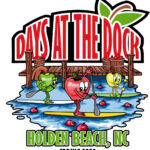
Days at the Docks Festival
April 29th & 30th
Holden Beach
The annual festival which started in the 1980’s occurs in April or May and is sponsored by the Greater Holden Beach Merchants Association. It’s the Holden Beach way to kick-off the Spring and start the vacation season. In addition to the food and arts & crafts, enjoy live music & entertainment, a horseshoe tournament and the world famous “Bopple Race”. Lots of activities for the entire family!
For more information » click here

Blue Crab Festival
May 17th & 18th
Little River SC
.
Little River has been celebrating the World Famous Blue Crab Festival since 1981. It is held on the waterfront in Little River and is one of the largest festivals in the Southeast. The purpose of this festival is one that supports and showcases the fabulous atmosphere of the local communities.
For more information » click here
Brunswick County invites residents to participate in lifesaving certification training
Brunswick County’s Risk Management and Parks and Recreation departments are partnering to offer First Aid/CPR/AED Certification Training in 2025. This new training program is designed to provide residents with the knowledge and skills needed to recognize and respond appropriately to cardiac, breathing, and first aid emergencies.
“Many accidents at work and at home—such as bruises and cuts sustained from tripping or burns given by heating equipment—can be helped by a bystander with the proper resources and training,” Risk Manager Andy Yoos said. “That’s why it’s important for everyone to know how to perform basic lifesaving care.”
The training is open to any Brunswick County resident 12 years of age and older. Participants under 18 years of age must be accompanied by an adult guardian for the entire training session. Upon successful completion of the course, participants will receive an American Trauma Event Management (ATEM) First Aid/CPR/AED certification card, which is valid for 2 years.
The 2025 training sessions will be held on Feb. 15 inside the Town Creek Park Community Building, April 26 inside the Leland Field House, June 7 inside the Lockwood Folly Community Building, Aug. 9 inside the Waccamaw Park Community Building, and Oct. 4 inside the Leland Field House. Participants must register and pay online before the training date.
There are only 12 seats available per training session and the registration fee is $10 per person. Each class will consist of an AM Session from 9 a.m. to 12 p.m., a 30-minute lunch break*, and a PM session from 12:30 p.m. to 3:30 p.m. You must attend and complete both sessions to receive certification.
*Participants must bring their own lunch and beverages.
Upcoming Training Session
Saturday, June 7, 2025 / Supply Area
Location: Lockwood Folly Community Building, 1691 Stanbury Rd SW, Supply, NC 28462
Time: 9 a.m. to 3:30 p.m.
Cost: $10 per person
Learn more and register online on the Brunswick County Parks and Recreation RecDesk website.
For questions or more information about the training program, email Brunswick County Risk Management.
For more information » click here
![]() Discover a wide range of things to do in the Brunswick Islands for an experience that goes beyond the beach.
Discover a wide range of things to do in the Brunswick Islands for an experience that goes beyond the beach.
For more information » click here.
Calendar of Events Island –
THB Newsletter (02/26/25)
Yoga Location Change
The Town of Holden Beach offers beginner friendly yoga classes on Mondays, Wednesdays and Fridays at 10:00 a.m. The class is taught by Alice Ledford. Fee is $6 for residents and $8 for non-residents. Classes will be held at the multipurpose court at Bridgeview Park.
Family Nighttime Easter Egg Hunt
The Town will hold its annual nighttime Easter Egg Hunt on Friday, April 18th beginning at 7:00 p.m. Teams of four will compete against each other. Participants will need to bring their own flashlights to the event and something to place their eggs in. Participants MUST register by April 7th. Space is limited to the first 100 families. Email Christy at christy.ferguson@hbtownhall.com to register. Check-in on the evening of the event will be on the sidewalk in front of Town Hall.
 HBPOA Easter Membership Meeting
HBPOA membership meeting at 10:00 a.m. on Saturday April 19th at Town Hall.
 Easter Sunrise Service
Holden Beach Chapel is sponsoring an Easter Sunrise Service at 6:00 a.m. Easter Sunday, April 20th beside the Holden Beach Pier.
Parks & Recreation / Programs & Events
For more information » click here
Reminders –
 Free Cleanup Week
The next Free Cleanup Week at the Brunswick County Landfill will take place April 21 through 26, 2025. Brunswick County property owners and residents can dispose of all materials, except for regular household trash and hazardous waste, free of charge during Free Cleanup Week. Individuals can dispose of metal, tires, electronics, latex paint, clothing, shoes, used oil, oil filters, antifreeze, gasoline, fluorescent bulbs, used cooking oil, smoke detectors, household batteries, rugs, mattresses, furniture, and yard debris in their designated area at the Landfill during this week. Participants must show proof of Brunswick County property ownership or residency. Brunswick County accepts various items at the Brunswick County Landfill year-round at no charge to Brunswick County property owners and residents. See a full list of accepted items on the Accepted Items and Tipping Fees webpage. For questions, contact Brunswick County Operation Services at 910.253.2520 or email OperationServices@brunswickcountync.gov.
Location:
Brunswick County Landfill
172 Landfill Rd NE
Bolivia, NC 28422
Hours of Operation:
Monday through Friday 7:30 a.m. until 5:00 p.m.
Saturday 7:30 a.m. until 3:00 p.m.
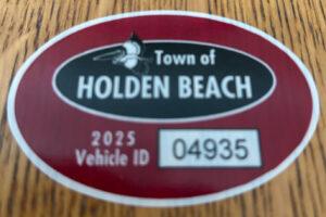 Hurricane Vehicle Decals
Property owners were provided with four (4) decals that were included in this month’s water bill. It is important that you place your decals in your vehicle or in a safe place. A $10 fee will be assessed to anyone who needs to obtain either additional or replacement decals. Decals will not be issued in the 24-hour period before an anticipated order of evacuation.
The decals are your passes to get back onto the island to check your property in the event that an emergency would necessitate restricting access to the island. Decals must be displayed in the driver side lower left-hand corner of the windshield, where they are not obstructed by any other items. Officials must be able to clearly read the decal from outside the vehicle.
Property owners without a valid decal will not be allowed on the island during restricted access. No other method of identification is accepted in an emergency situation. Click here to visit the Town website to find out more information regarding decals and emergency situations.
 Smoke Detectors
Time change means time to check smoke detectors, too. The fire department is encouraging people to test their smoke alarms and change the battery. Smoke alarms should be replaced every 10 years, whether they are battery-operated or hard-wired.
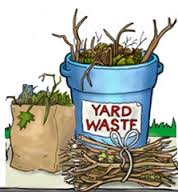 Yard Waste Service
Yard debris pick-up will be provided twice a month on the second and fourth Fridays during the months of March, April, and May. Please have yard waste placed at the street for pick-up on Thursday night. No pick-ups will be made on vacant lots or construction sites.
Debris must be placed in a biodegradable bag or bundled in a length not to exceed five (5) feet and fifty (50) pounds. Each residence is allowed a total of ten (10) items, which can include a combination of bundles of brush and limbs meeting the required length and weight and/ or biodegradable bags with grass clippings, leaves, etc.
 News from Town of Holden Beach
The town sends out emails of events, news, agendas, notifications, and emergency information. If you would like to be added to their mailing list, please go to their web site to complete your subscription to the Holden Beach E-Newsletter.
For more information » click here
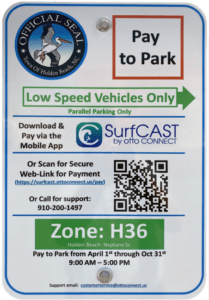 Paid Parking
Paid parking in Holden Beach
Paid parking will be enforced from 9:00 a.m. to 5:00 p.m. daily with free parking before and after that time. All parking will use license plates for verification.
Rates
Parking rates for a single vehicle in all designated areas will be:
$5 per hour for up to four hours
$20 per day for any duration greater than four hours
$80 per week for seven consecutive days
Handicap Parking
A vehicle displaying a handicap license plate and/or hang tag parked in a designated handicap space is free. Any other parking space will require a parking permit via the app.
Annual Passes
Annual permits for the calendar year allow vehicles (this includes low-speed vehicles and trailers) access to designated parking.
$175 for a single vehicle
Passes can be purchased via the app, website or by telephone.
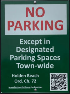
Where to Park
Per ordinance, there is no parking on the streets or rights-of-way except in designated parking spaces identified by Pay-to-Park signs. Click here to view an interactive map. The table with authorized parking can be viewed below.
Citations will be issued for:
• Parking without an active paid permit in a designated parking area
• Parking within 40 feet of a street intersection
• Parking in a crosswalk, sidewalk, or pedestrian access ways
• Parking blocking a driveway or mailbox
• Parking facing opposing traffic
• Parking in a no parking zone, or within right-of-way
• Parking on any portion of the roadway or travel lane
• Parking a non-LSV vehicle in an authorized LSV location
How Do I Pay to Park
The Town uses the SurfCAST by Otto Connect Mobile Solution. This is a mobile app downloadable for Apple and Android devices. Download the app today. Users will setup their account, enter their license plate details and pay for parking directly on the app. Alternatively, users can scan the QR Code located on the parking signs to access a secure website.
The Otto Connect customer service team will be available to help via phone and email.

Solid Waste Pick-Up Schedule
GFL Environmental change in service, October through May trash pickup will be once a week. Trash collection is on Tuesdays only.
Please note:
. • Trash carts must be at the street by 6:00 a.m. on the pickup day
. • BAG the trash before putting it in the cart
. • Carts will be rolled back to the front of the house
GFL Refuse Collection Policy
GFL has recently notified all Brunswick County residents that they will no longer accept extra bags of refuse outside of the collection cart. This is not a new policy but is stricter enforcement of an existing policy. While in the past GFL drivers would at times make exceptions and take additional bags of refuse, the tremendous growth in housing within Brunswick County makes this practice cost prohibitive and causes drivers to fall behind schedule.
Solid Waste Pick-up Schedule –
starting October once a week
Recycling –
starting October every other week pick-up
Curbside Recycling – 2025
GFL Environmental is now offering curbside recycling for Town properties that desire to participate in the service. The service cost per cart is $119.35 annually paid in advance to the Town of Holden Beach. The service consists of a ninety-six (96) gallon cart that is emptied every other week during the months of October – May and weekly during the months of June – September.
Curbside Recycling Application » click here
Curbside Recycling Calendar » click here
THB Newsletter (03/05/25)
2025 Recycling Deadline
Renewals for 2025 are due by April 1st. If payment is not received by April 1st, you recycling cart will be picked up by GFL. If you decide to reestablish the service after your cart is picked up, you will be assessed a fee of $50, in addition to the annual service cost. The 2025 service cost is $119.35 annually paid in advance to the Town of Holden Beach. The service consists of a 96 gallon cart that is emptied every other week during the months of October – May and weekly during the months of June – September. You may apply in person at Town Hall or by clicking here to download the application and mailing it in with your check payment.

Trash Can Requirements – Rental Properties
GFL Environmental – trash can requirements
Ordinance 07-13, Section 50.08
Rental properties have specific number of trash cans based on number of bedrooms.
* One extra trash can per every 2 bedrooms
..
§ 50.08 RENTAL HOMES.
(A) Rental homes, as defined in Chapter 157, that are rented as part of the summer rental season, are subject to high numbers of guests, resulting in abnormally large volumes of trash. This type of occupancy use presents a significantly higher impact than homes not used for summer rentals. In interest of public health and sanitation and environmental concerns, all rental home shall have a minimum of one trash can per two bedrooms. Homes with an odd number of bedrooms shall round up (for examples one to two bedrooms – one trash can; three to four bedrooms – two trash cans; five – six bedrooms – three trash cans, and the like).
Building Numbers
Ocean front homes are required to have house numbers visible from the beach strand.
Please call Planning and Inspections Department at 910.842.6080 with any questions.
§157.087 BUILDING NUMBERS.
(A) The correct street number shall be clearly visible from the street on all buildings. Numbers shall be block letters, not script, and of a color clearly in contrast with that of the building and shall be a minimum of six inches in height.
(B) Beach front buildings will also have clearly visible house numbers from the strand side meeting the above criteria on size, contrast, etc. Placement shall be on vertical column supporting deck(s) or deck roof on the primary structure. For buildings with a setback of over 300 feet from the first dune line, a vertical post shall be erected aside the walkway with house numbers affixed. In all cases the numbers must be clearly visible from the strand. Other placements may be acceptable with approval of the Building Inspector.
State Transportation Improvement Program (STIP)
THB Newsletter (02/03/25)
Public Input Opportunity
The N.C. Department of Transportation is inviting the public to provide feedback on the Draft 2026-2035 State Transportation Improvement Program (STIP). The STIP is developed under the Strategic Transportation Investments law (STI), which established the Strategic Mobility Formula.
Over the past 18 months, NCDOT has worked closely with the public, legislature, local planning organizations and other stakeholders to implement this law and develop the Draft STIP.
As part of this effort, NCDOT will host regional drop-in sessions (see flyer) across the state between February 17 and March 17, 2025. These sessions and the broader outreach effort aim to gather input on:
- The variety and geographic diversity of projects;
- The process used to develop the STIP;
- Ideas for improvement.
Feedback from these sessions will also help shape the development of the 2028-2037 STIP.
To learn more about this outreach effort, we encourage you to watch a short informational video at https://youtube/yRhAgZ_ywiw?si=PUO4sClDuqSyU682.
Your Input Matters
This communication is an invitation to participate in shaping North Carolina’s transportation network. The public comment period will run from January 31, 2025, to April 4, 2025.
Upon Further Review –
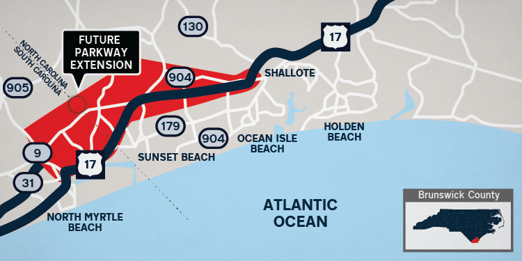 Carolina Bays Parkway project S.C. 31
Boom or doom: How a new highway could transform rural Brunswick County
A new road in southern Brunswick County will open the flood gates of opportunity for some but could close the doors of homes and businesses for others. The Carolina Bays Parkway Extension project could be the missing link for rural towns to become Brunswick’s next big, booming city. However, some small-town business owners are questioning if the boom will be big enough to reach them. The N.C. Department of Transportation and the S.C. Department of Transportation are working together to extend S.C. 31, known as Carolina Bays Parkway, from S.C. 9 in Horry County, South Carolina, to U.S. 17 in Brunswick County. “The extension would provide a more direct and efficient movement of traffic seeking to bypass congestion within the areas of Calabash in North Carolina as well as Little River and the Grand Strand areas in South Carolina,” per NCDOT’s website. “As a result, local and tourist traffic on area roadways would experience less congestion and delays.” That area includes Brunswick places on each side of U.S. 17: Growing Carolina Shores, Calabash and Sunset Beach at the coast and inland more rural Hickman’s Crossroads, Ash and Longwood. South Carolina is almost ready to begin construction on its end, but North Carolina has yet to find a landing spot as well as funding. With a majority of potential connection spots near Hickman Road and a new shopping center on the way near Carolina Shores, people and businesses in southern Brunswick County could be teetering on trouble or treasure.
Twenty years in the making
The Carolina Bays Parkway Extension project began in 2006 with a feasibility study with conceptual alternative routes and has evolved into seven potential routes being studied. Interactive maps of the alternatives can be viewed on NCDOT’s website. The NCDOT portion of the project is only funded for preliminary engineering, NCDOT spokeswoman Lauren Haviland said, but not for right-of-way, utilities or construction. Right-of-way, utilities and construction for NCDOT’s part of the project is estimated to cost $809,700,000, Haviland said. Shallotte Mayor Walt Eccard has watched and supported the road project for about 10 years. He said it’s a complicated project with multiple agencies involved in both states. “I’m a big supporter of this project, I think it’s critical,” Eccard said. “I think the area will benefit, I think citizens will benefit in their travels.” If constructed, the route will be built in phases and enhance evacuation routes, improve safety and smooth out traffic flow as the county continues to grow in population. Exact costs and timelines to construct each phase for the North Carolina side have not been determined, Haviland said. Despite eagerness, Eccard said NCDOT has no funding to support its portion of the road. “Ultimately, we cannot move forward even when a route is selected until we have adequate funding and that’s been an issue for several years now,” Eccard said. Horry County in 2016 passed a capital projects sales tax referendum that allocated $125 million for its portion of the project, according to NCDOT’s website. In North Carolina, $4.1 million was allocated for planning and design. Public hearings for the North Carolina side of the extension have been delayed several times but, Eccard said, there is hope the draft environmental impact statement will be available this spring so public hearings and review can start, and a final route can be selected by NCDOT. Haviland confirmed a public hearing will be held in late spring if the draft environmental impact statement is approved soon. NCDOT has seven alternative maps for preferred routes in Brunswick County that will eventually dump onto U.S. 17. However, five alternatives cross on the northern side of U.S. 17 around Hickman’s Crossroads along Hickman Road in Calabash.
Impacting generations
Distant relatives David and Myles Bennett were born and raised in the Calabash area. Myles was raised on Thomasboro Road near the heart of Calabash while David was raised on the northern side of U.S. 17 around Hickman’s Crossroads. The Bennetts have been in the Calabash area since the 1800s, Myles Bennett said, noting most know their family through farming and the seafood restaurant business. David Bennett is also related to the Hickman’s, who have lived in the Ash and Longwood areas since the 1700s. He said the property he lives on has been in his family’s name since 1845 and that his father’s entire life was spent on the property. “His life was here. … And he was so worried that if they took that away, then he had to leave here,” he said. One of the alternative routes connecting near Hickman’s Crossroads would place the road on top of David Bennett’s dining and living room and partially through the Manley Bennett Cemetery that holds approximately 300 graves, with some headstones dating back to the 1800s. SCDOT is currently working with NCDOT to secure the environmental permit from the Federal Highway Administration, SCDOT spokeswoman Hannah Robinson said in early January. “Once the document is secured, right-of-way acquisition can begin,” Robinson said. “At this time, we anticipate construction to begin in 2028.”
Needed project with a questionable future
The timeline and future of the project is still unknown. Though project start and completion dates are still in question, local leaders look forward to the additional road and evacuation route. “The county only has one main artery and it impacts the ability for people to move around,” Carolina Shores Mayor Dan Conte said. “The extension would be a boom to Ash, but it would also help us.” The extension is a “critical infrastructure need,” said Conte, because it will give southern Brunswick County residents more opportunity to move throughout the county with less traffic, especially during an evacuation. “There’s no provision right now to easily move people from our town or from the southern part of the county,” he said, noting N.C. 130 quickly floods during heavy rainfall and residents need an alternative route. With proposed and already approved developments near Ash, Calabash and Longwood areas piling up, the road could also declutter future traffic. Myles Bennett echoed Conte’s thoughts, believing the extension would help decongest existing traffic-prone areas. However, his neighbor Hannah Williams Crane fears the road will only make things worse. Crane was also raised on Thomasboro Road and has deep roots to the Calabash area through her mother’s side of the family, who were the Moore’s. She said Hickman’s Crossroads is already “so congested with traffic.” Many drivers who often travel through Hickman’s Crossroads already plan to get stuck, she added.
Local businesses consider the impact
Though the new road means less traffic along currently congested roads, south traveling traffic flow could stop in front of Carolina Shores as popular retail stores like Walmart and Publix build along U.S. 17. Calabash Deli co-owner Sean Grady said the extension could have a positive or negative impact on the Calabash community. Traveling will likely be easier but new shopping centers and fast food chains could take away customers from small businesses. Existing traffic jams and recent closure of the Calabash Bridge have already deterred potential customers from visiting the small town, he said. “A lot of people are avoiding Calabash because it’s a small, quaint town and some people don’t want to get caught up in the traffic and they kind of stick to the major highway and drive right past us,” Grady said. Like Grady, Coffee Cottage and Calabash Garden Tea Room owner Kathy Cody said it is hard to say the exact impacts the extension will have on the Calabash community since there is no finalized plan nor promised timeline. “The longer it takes them to actually initiate it and make it happen, the harder it’s going to be, and the more people and neighborhoods are going to be affected,” she said.
New road, high housing market, low rural life
Some major housing and commercial developments have already been approved around the potential route area, like the 2,950-home development named Ashton Farms. Housing developments are coming in while rural lifestyles are being pushed out. Myles Bennett and Crane explained they have already seen changes to Calabash as nearby wooded areas are cleared for new housing developments and vehicular traffic increases. “The stuff in front of us has been woods my entire life and just last year we saw them start clearing trees right across the road from Thomasboro,” said Crane, noting they are expected to have over 1,000 new neighbors. The heart of Calabash was built with family-owned businesses. Calabash would have to add more grocery stores and “convenient” businesses if the extension were to push more people to Calabash, Crane said. The “small town feel,” she noted, could be negatively changed. Like Calabash, the Ash and Longwood communities are full of generational families and homes, Crane and David Bennett said. “My grandfather loved this place, and he used to say that J.D. Rockefeller did not have enough money to buy his place,” David Bennett said. Some fear the new road, if built near Hickman’s Crossroads or Ash, will drain the history and culture of the Ash community. “It’s no longer going to be family land, it’s no longer going to be the quiet town that we know,” Crane said. David Bennett’s mother was from Longwood. He said the Longwood community was named after his great grandfather, noting he has relatives that will also be uprooted. The road could cause David Bennett and many others to pack up their lives with nowhere else to go. “I don’t want to go anywhere, I want to stay here, this is my home. … I don’t think people think about the lives that something like that is going to affect,” said David Bennett, noting many local generational families would not survive if they were displaced and forced to live elsewhere. Ocean Isle Beach Mayor and real estate agent Debbie Smith said road projects “typically” have a positive impact on property values, noting homes closer to the new road could increase in value. “Then again, it may change some of the uses from rural farming to more urban development,” Smith said. She said the road will be beneficial to the whole area and “critical for the future of our area” since it will increase access and emergency evacuation routes throughout the county and across state lines. “I think more than anything it would improve transportation and maybe keep some of our roads from becoming overburdened. … It is desperately needed for the area,” Smith said.
Where to grow from here
Brunswick County is seeing tremendous growth and municipalities are planning projects, setting budgets and updating unified development ordinances to prepare for more. “Until we see the final plans, it’s really hard to say,” Eccard said of the extension bringing more traffic to Shallotte. Conte said Carolina Shores is almost completely built out with no room for more major developments. Though the town has no more room, he said traffic will always be an issue. Families living along the alternative routes are conflicted, depressed and worried because they do not know what to do, David Bennett said. For example, he said, upgrading his house could be a waste of time if the home is destroyed in a few years. “It’s constantly in the back of your mind. …. Where are we supposed to go? What are we supposed to do?,” he said. Potential impacts to noise, low income and disadvantaged populations, cultural resources and the environment are considered when selecting the least environmentally damaging and practicable alternative route, Haviland said. “In cases where impacts to private properties are unavoidable, NCDOT will work with individual property owners to help minimize impacts or mitigate through appropriate compensation,” Haviland said. The NCDOT representative said it should have a recommended alternative route selected after the public has time to review the draft environmental impact statement, look at preliminary designs and make formal public comments. “As part of the alternative analysis process, impacts to communities, properties, landowners and businesses are considered. … Comments from the public are always welcomed and encouraged. The formal comment period will take place once the public hearing has been scheduled,” Haviland said.
Read more » click here
Previously reported – November 2023
Carolina Bays Parkway project S.C. 31
As many of you know the extension of Carolina Bays 31 from SC to NC has been an ongoing project for many years that has been accelerated by the fact that SC has the funding and the desire to complete the existing SC31 to the NC state line. This has caused NC to produce a plan even though they have no funding for the road to enter NC and go north towards Wilmington.
There have been numerous rumors about what routes are and are not being considering and quite honestly there are some things that we do know for fact after the most recent meeting but there are even more things that we, and NCDOT for that matter, don’t have answers to at this point. The purpose of this communication is to make everyone aware of what we know. At the Sept Board meeting the Community Impact Committee made a presentation that clearly identified 2 of the proposed routes along with many of the details surrounding a project like this. It is suggested that if you haven’t seen it to review the below “Enumerate Engage – Login” link for more detail about this project.
What we know based on the last meeting with the NCDOT two weeks ago;
- SC has the funding thru a sales tax in Horry County
- SC has asked NC where to end their construction to the NC SC state line or in other words, where does NC want the SC portion to end?
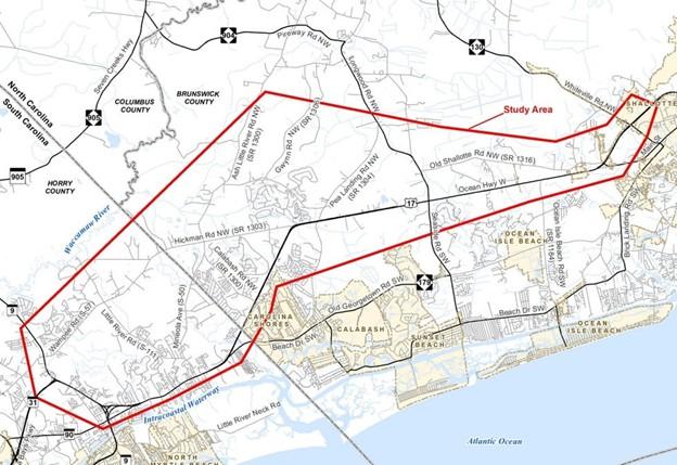
- NC has selected route 4 which is east of Indigo Farms near Hickman Road (NC 57)
- Carolina Bays is a high priority for the BC county region of NCDOT but there is NO funding for this project, and it will have to compete with other projects throughout NC based on a set of criteria which at this point has placed it as a low priority within NC.
- NCDOT has decided to have a 3 Phase plan for the road in NC.
- Phase 1 will take SC31 from the state line to a new interchange at Ash Little River Road
- Phase 2 will take it from there to Longwood Road NW (Rte. 904) near the Grissettown Longwood Fire and Rescue Department.
- Phase 3 will take it from there to Route 17 at either the Rte. 904 or the Rte. 130 intersection
- The Environmental Impact Study (EIS) although not officially approved is close to approval and once it is approved there will be 2 public meetings (one in NC & one in SC) to solicit input on the 2 alternative routes to connect to 17. These meetings will take place sometime in mid to late Q1 ’24
- At this point only Phase 1 & 2 are locked in with preliminary funding expected in 2025 or 2026
- Phase 3 is still under review. No route has been selected albeit there is solid rationale for both alternatives and a route must be selected prior to any State or Federal funding proposals that are to be are submitted.
- The public meetings will be VERY important in determining the Phase 3 route !!!
Without funding, NCDOT continues Carolina Bays Parkway discussion
On Oct. 16, the Grand Strand Area Transportation Study (GSATS) Transportation Advisory Committee (TAC) and the GSATS Policy Committee with both North Carolina and South Carolina participants met. Both meetings were held at Ocean Isle Beach Town Hall. Both meetings were open to the public and focused on the Carolina Bays Parkway Extension project that will extend Carolina Bays Parkway — also known as South Carolina Highway 31 — from South Carolina Highway 9 in Horry County, South Carolina, across the North Carolina state line to US Highway 17 in Brunswick County. Representatives from participating towns, cities and counties and project leads from the North Carolina Department of Transportation (NCDOT) were in attendance. During the combined policy meeting, participants received a presentation by NCDOT Division 3 Engineer Chad Kimes and Project Development and Environment Analysis (PDEA) Engineer Mason Herndon. Kimes told the committee that NCDOT wants to start obtaining funding for the extension by the end of next year to get the North Carolina side of the project moving. “I can tell you, Carolina Bays is one of our number one priorities in this region that’s unfunded, currently, by the state of North Carolina,” he said. Kimes explained that they are going to try several ways to get state funding over the next few months and they will know a little more by spring 2024. He noted that the project had been submitted for state funding in the past, however, they have yet to receive any money. “The lowest project to score in our scoring system that got picked up in our [Transportation Improvement Plan (TIP)] program scored a 74.6,” he said. “We were scoring the Carolina Bays at a 62.71. The difference between that 62 and that 74.6 is about $14 billion worth of projects in between, so there was a big difference…” He told the board that NCODT will be applying for federal grants too, however, all grants will require a match by the state. “On a price tag like this, North Carolina can match anywhere between 30 and 50% on federal grants but we will be pursuing it,” Kimes said. If they do apply for federal grants, the project may score better in the prioritization process because it will bring down the overall cost of the project for North Carolina. Kimes noted they are looking to lower project costs by eliminating interchanges and installing superstreets, adding they may reduce the number of right a ways, too, and that things can be changed in the future. Kimes said they are seeking to connect the project to US Highway 17 sooner to lower overall costs and are still considering installing tolls along the project to offset the total cost as well. Herndon gave the Policy Committee, along with a good-sized audience, a presentation on NCDOT’s progress on the project, funding and planning. Herndon said they are studying seven different routes in the draft Environmental Impact Statement (EIS), however, alternative route four is the preferred one at the moment. He explained that one of the interchanges would go up to Ash Little River Road in Ash. Alternative four would connect with South Carolina at Hickman Road Northwest in Calabash, and travel through Hickman’s Crossroads. It would cross the Hickman’s Branch River and the Cawcaw Swamp. The suggested route would take the project to Gwynn Road Northwest in Longwood and Bland Road Northwest in Longwood. If alternative map four is chosen for the extension, the project would not connect with US Highway 17 until its intersection with Longwood Road and Seaside Road near Grissettown. “Alternative four ties into [US Highway] 17 at the 904 intersection,” Herndon said. Asked how much money had been committed on North Carolina’s end, Herndon said none. He said they were told by the Federal Highway Administration (FHA) to look at an “affordable solution” to get the project started since they have no funding currently. He said NCDOT has been working on it and has sent the draft EIS, which includes all seven alternatives, to the FHA. He said NCDOT will eventually have a financial plan to show their commitment to the entire project with South Carolina. Herndon said the project would be done in phases — phase one would either stop at the North Carolina and South Carolina boarder or carry into Brunswick County up to Ash Little River Road. “Now, we’re not talking about this as the complete project, this is just phase one of the project,” he said. “Every project that we’ve got is so many miles long that we build it in sections, and it has to have logical termini. So, basically, those are the two logical termini we feel like we can start with.” If phase one were carried into Brunswick County, he said an interchange would be built at Ash Little River Road. “This would require us to do improvements along Hickman Road and along Ash Little River Road to get traffic to 904 until phase two is built,” he said. A timeline for phase one could not be provided at this time. “Until we actually have money in the bank for this project in North Carolina… that’s going to be when we can really develop a timeline,” Herndon said. He said they hope that having this plan, with some committed funds, will help move things forward, and also explained that the final EIS may not get approved without a full financial plan for the entire project. Kimes said he felt confident that they will receive right of way funding by the end of 2024 to kickstart the project. With the project plan coming together, Herndon said he expects public hearings to commence in early 2024. Shallotte Mayor Walt Eccard said he has been telling folks for three years that there would be a meeting to discuss the draft EIS. He asked how sure they were about the public hearings and if early 2024 was a reasonable date to tell people. In response, Herndon said he felt fairly confident that there would be public meetings for the extension, and they could begin in early 2024. He noted that the final EIS meeting might not be until the end of 2024 or beginning of 2025. “The public hearings after the draft EIS [are] to give public input on what we’re proposing,” Herndon said. He explained the final EIS would contain the final determined route for the Carolina Bay Parkway Extension, however, the drafted EIS, used for information purposes, will include all seven alternative routes. Brunswick County Board of Commissioners Chair Randy Thompson said there would be major construction work that would take years if alternative four is chosen. He said he was concerned about the potential traffic on affected roads during the duration of the project’s construction, noting that traffic is already a major issue with the county’s increasing population growth. “We need the highway; there’s no doubt about that. We need the highway,” Thompson said. Kimes said they will look at all the potentially effected roads to see what they can handle and make sure steps are in place for potentially needed improvements. All of the alternative routes can be found online on the NCDOT website at https://www.ncdot.gov/projects/carolina-bays-parkway/Pages/project-maps.aspx
Corrections & Amplifications –
With improvements made,
a Brunswick rest area and visitor center to soon reopen
The Brunswick County Visitors Center, a state-operated facility in Shallotte, is reopening after several delays. The facility, located at the intersection of U.S. 17 and N.C. 130 between Wilmington and Myrtle Beach, South Carolina, has been closed for renovations since fall 2023 and has not yet reopened. Though the center and facility were set to open in January, the completion date has moved to early March. Here’s the latest.
Project details and timeline
The project involved several improvements, including a new family restroom facility, water line, updated drainage and landscaping improvements. Kowen General Contractors began construction in October 2023, but according to Lauren Haviland, spokesperson for the North Carolina Department of Transportation, the firm did not start groundwork until March 2024.
Why the delay?
“That delay was due to the contractor had never done work for NCDOT before and was unfamiliar with the processes, such as working with certified sub-contractors,” Haviland previously told StarNews in an email. “Also, several items of work have been added, extending their agreement to the end of the year.”
When will it open?
The center will reopen on March 3, Shallotte Town Manager Mimi Gaither said. Andrew Barksdale, NCDOT communications officer, said the restrooms and parking lot will open March 3 and the Brunswick County Visitor Center will open March 4.
Read more » click here
Previously reported – January 2025
When will the Brunswick County Visitors Center re-open?
The Brunswick County Visitors Center, a state-operated facility in Shallotte, is a popular rest stop for those driving along U.S. 17. Located at the intersection of U.S. 17 and N.C. 130 between Wilmington and Myrtle Beach, the facility is a North Carolina Department of Transportation rest area that serves thousands of patrons each year. But the facility has been closed for renovations and has not yet re-opened. A reader recently wrote to the StarNews and inquired about plans to re-open the facility. Here’s what we found out.
When did the facility close?
The visitors center closed in fall 2023 for construction.
What did the project include?
According to a previous StarNews article, the project involved several improvements, including a new family restroom facility, water line, updated drainage and landscaping improvements. The article stated a construction contract for $981,000 was awarded to Kowen General Contractors out of Maxton for the project.
What was the project timeline?
Kowen was able to begin construction in October 2023, but according to Lauren Haviland, spokeswoman for the NCDOT, the firm did not start groundwork until March 2024. “That delay was due to the contractor had never done work for NCDOT before and was unfamiliar with the processes, such as working with certified sub-contractors,” Haviland said, in an email. “Also, several items of work have been added, extending their agreement to the end of the year.”
What items were added to the project?
Haviland said additional work includes waterline and hydrant installation, additional tile work, removing and replacing existing sidewalks, additional support at one of the entrances, cabinet work in one of the rooms, and removing and replacing the fascia. Haviland noted that while the original contract amount was $981,000, the project was funded for $1.5 million. As of the November 2024 estimate, Haviland said NCDOT had spent about $1,352,000.
When will it be completed?
According to Haviland, construction is expected to be completed in late January 2025.
Read more » click here
Odds & Ends –
 Brunswick Community College holds groundbreaking for new first responder training center
Brunswick Community College held a groundbreaking ceremony Friday morning for the new “Alan Holden Public Safety Center,” named after the chair of BCC’s Board of Trustees. The building will be located directly behind the main entrance to the college off highway 17. Construction of the more than 28,000 square-foot facility is scheduled to begin Monday. The state-of-the-art facility will feature a wide array of specialized labs and training rooms. Including a moveable wall tactical firearm room, a self-defense arrest techniques mat room, fire truck and police scenario simulators, and EMS scenario training rooms. College president Gene Smith says the new facility will continue BCC’s mission of expanding with the community. “This facility will provide the opportunity for BCC to continue to serve our students and meet the needs of our community for many, many, many, years to come,” Smith stated. Construction is estimated to finish in March of 2026.
Read more » click here
BCC breaks ground on Alan Holden Public Safety Center
Brunswick Community College (BCC) on Jan. 31 celebrated the groundbreaking of the Alan Holden Public Safety Center today, marking the beginning of a transformative project that will bolster educational and career opportunities while addressing critical workforce needs in the region. Construction of the 28,278-square-foot facility is scheduled to begin on Feb. 3, with an estimated completion date of March 2026. The state-of-the-art facility will feature a wide array of specialized labs and training rooms, including a VirTra Simulator, moveable wall tactical firearm room, self-defense/arrest techniques mat room, driving simulators, EMS scenario training rooms, and an apparatus bay. It will serve as the new home for numerous programs and certifications designed to train the next generation of public safety professionals. “Today’s groundbreaking is a monumental step forward in Brunswick Community College’s mission to meet the growing needs of our community,” said Dr. Gene Smith, President of BCC. “The Alan Holden Public Safety Center will provide top-tier education and training opportunities for students and support in-service training for our local law enforcement officers, fire, and rescue personnel. We are deeply honored by Alan Holden’s generosity and his trust in BCC to carry forward a legacy of excellence and service to our community.” The facility will house Associate in Applied Science degree programs in Criminal Justice Technology, Emergency Medical Science (EMS), and Public Safety Administration with specializations in Corrections, Law Enforcement, and Emergency and Fire Management, and 911 Communication and Operations. In addition, the center will offer diploma, certification, and continuing education courses such as Basic Law Enforcement Training (BLET), Emergency Medical Responder (EMR), Advanced Life Support (ALS), and a variety of firefighter training programs. “This project is a game changer for the safety and well-being of the people of Brunswick County and beyond,” said Sheriff Brian Chism. “The Alan Holden Public Safety Center will provide invaluable training resources for public safety professionals, ensuring they are prepared to protect and serve at the highest level. We are grateful to both Mr. Holden and BCC for their continued contributions to and support of our community.” For more information about Brunswick Community College and the Alan Holden Public Safety Center, visit brunswickcc.edu.
Read more » click here

Alerts
Brunswick County uses ReadyBrunswick as part of the County’s effort to continuously improve communications during emergency situations within our area. Powered by Everbridge, the ReadyBrunswick notification system sends emergency notifications in a variety of communication methods such as:
- Landline (Voice)
- VoIP (Voice over Internet Protocol)
- Mobile (Voice)
- Mobile SMS (Text Messaging)
In the case of an emergency, you may choose to receive notifications via one or all of these communication methods. It’s recommended that you register several media options to receive messages in the event a particular communication device is unavailable.
For more information » click here
Brunswick County Emergency Communications Notification System
Get notified about emergencies and other important community news by signing up for our ReadyBrunswick Emergency Notification System. This system enables us to provide you with critical information quickly in a variety of situations, such as severe weather, unexpected road closures, missing persons, evacuations of buildings or neighborhoods, and more. You will receive time-sensitive messages wherever you specify, such as your home, mobile or business phones, email address, text messages and more. You pick where, you pick how.
SIGN UP HERE to choose the type of alerts you want to receive
Save the Date:
ReadyBrunswick Preparedness Expo is Wednesday, May 7
Are you prepared for emergencies? Come by the ReadyBrunswick Preparedness Expo on Wednesday, May 7, 2025, anytime between 11 a.m. to 2 p.m. to meet with our team members and other local organizations to learn more about disaster preparedness and recovery in Brunswick County.
This family-friendly event is free to attend and will feature over 20 local organizations that are ready to help prepare you for local hazards and threats, guide you and your family in developing an emergency plan, and teach you about organizations that can assist with recovery needs.
There will be free Sunset Slush Classic Italian Ice, popcorn, a vast display of rescue vehicles, a free raffle contest, and many handouts related to emergency preparedness and recovery.
For any questions, contact our Emergency Management team at 910.253.2589 or via email.
Find preparedness information on our website anytime at brunswickcountync.gov/emergency. Learn more about the ReadyBrunswick Emergency Notification System and sign up at brunswickcountync.gov/e-alerts.
ReadyBrunswick Preparedness Expo Details
When: Wednesday, May 7, 2025, from 11 a.m. to 2 p.m. (come and go anytime)
Where: Brunswick County Government Center, 30 Government Center Drive NE, Bolivia, NC 28422 (Parking available in front of the David R. Sandifer Administration Building)
What to Expect: All Brunswick County community members and visitors are welcome to come and meet local organizations that can guide you through emergency preparedness and recovery activities.
For more information » click here
This and That –
State’s fix for costly litter problem ‘not efficient or sufficient’
The cleanup of more than 7,000 tons of litter in North Carolina cost state agencies, local governments and nonprofits more than $56 million in 2023, according to a new report. Those figures highlighted in “The Cost of Litter in North Carolina,” a 14-page report created through a collaboration of nonprofits and the Duke University Environmental Law and Policy Clinic, are just the tip of the trash pile. “That’s a severe undercount,” said Rob Clark, Cape Fear River Watch Water Quality Programs manager and a coauthor of the report. “The issue is much, much worse than this report was able to convey.” The figures included in the report were pulled together from information obtained through public records requests, informal requests, and budgets from the North Carolina Department of Transportation and 44 nonprofits. Of nearly 40 of the municipalities requested to provide information, 19 responded. There are more than 500 municipalities in the state. Even on the low, low end, the pounds of litter and costs associated with removing it from roadsides, ditches, and creek and river banks to name a few, conveys a narrative that North Carolina has a costly, statewide litter problem. But the economic impacts of litter are only part of the story, one the report’s authors hope to place into the hands of state legislators. That’s because the basic approach to addressing litter in the state — spending money to clean it up — is not efficient, Clark said. “It doesn’t address the issue properly,” he said. “It addresses the byproduct of the litter issue, but not the sources. It’s like you’re Band-Aiding over an artery. It’s not efficient or sufficient.” That’s why the report, which was also compiled by North Carolina Conservation Network, Haw River Assembly, and MountainTrue, includes recommendations aimed at reducing litter at the source, keeping it out of the environment, and saving tax dollars. One of the report’s main recommendations, Clark said, is that the North Carolina General Assembly reinstate the ability of local governments to regulate auxiliary containers, specifically single-use plastics such as grocery bags, cups, bottles and other types of food packaging. In a last-minute move, legislators injected into the 2023 state budget language that prohibits counties and cities from adopting rules, regulations, ordinances, or resolutions that restrict, tax, or charge fees on auxiliary containers. The provision stopped locally elected officials in Asheville from moving ahead on a vote to ban single-use plastic bags and Styrofoam food containers. “We were really close for that to come up to a vote here locally and then the General Assembly put that provision into the state budget,” said coauthor Anna Alsobrook, French Broad Riverkeeper and MountainTrue’s French Broad watershed science and policy manager. The law also squashed local elected officials in Durham from deciding whether to require retailers tack on a 10-cent fee for each plastic bag given out to customers in restaurants, grocery stores and shops. “It’s really unfortunate that the state legislature took away the right of local governments to regulate pollution in their own jurisdictions,” Alsobrook said. “We’re hoping to change that.” North Carolina Sen. Julie Mayfield, D-Buncombe, and Durham Democrats Sen. Natalie Murdock and Sen. Sophia Chitlik, last month introduced a bill that would repeal limitations on auxiliary containers. The same year legislators banned a ban on single-use plastics. A survey conducted by Mason-Dixon Polling & Strategy showed that more than 80% of some 650-700 North Carolinians polled across the state supported regulations on single-use plastics, Alsobrook said. The report found that the amount of single-use plastic litter – everything from cigarette butts, Styrofoam, bottles, bags, and food wrappers – picked up throughout the state has steadily climbed since the late 1960s. In the ravages left in western North Carolina from Hurricane Helene, there is one rather ominous, tell-tale sign illustrating the abundance of single-use plastics in the environment. “There’s a ton of devastation all over the place, but there’s tons and tons of plastic films and bags hanging from trees in any given direction,” Alsobrook said. “I think that was one of the most stark things we saw for a really long time. It’s very apocalyptic looking.” And there is ongoing research about the potential human health effects of microplastics, which are considered ubiquitous in the environment because they have been found in every ecosystem on the planet. Other recommendations in the report include the statewide implementation of a bottle deposit system where residents would receive a deposit for returning empty, single-use bottles, using the Clean Water Act in waters declared federally impaired as a result of litter pollution, and boosting funding the state transportation department’s litter cleanup efforts. The North Carolina Department of Transportation “by far” carries the burden for litter cleanup in the state, the report concludes. NCDOT spent more than $25 million of taxpayer funds to clean litter in 2023, according to the report. The department has spent about $270 million on litter cleanup over the past 15 years. Recommendations included in the report are not new, “crazy ideas,” but rather policies that exist in other states and countries, Clark said. “We’re just trying to take good policies and procedures that have worked in other places and implement them in our state,” he said. “Litter is, I think, viewed as an individual issue in our society. It’s seen as a failure of an individual, a litterbug. But really the reality of the situation is it’s a production issue, especially with plastic. There’s just so much production that we’re essentially drowning in it. We need to seriously address force reduction if we’re really going to get a handle on it.”
Read more » click here
Car insurance companies ask for 22.6% rate increase in North Carolina
Companies asked for proposed rate hike to take effect Oct. 1
Auto insurance companies are asking for a sizable rate increase in North Carolina, up an average of 22.6%. The request for the rate increase was filed by the North Carolina Rate Bureau on Monday, Feb. 3, the state Department of Insurance said. The companies asked that their proposed insurance rate hike take effect Oct. 1. Now that the request has been filed, the insurance commissioner has 60 days to review it, according to the department. During his review, Commissioner Mike Causey will determine if the companies’ request is justified. If he disagrees with their request, Causey has the power to have the Department of Insurance negotiate a settlement, or he can call for a hearing. State officials said settlements have been reached in the past, but if the companies’ request goes to a hearing, a hearing officer would have the final say. Monday’s filing comes two years after the companies asked for a 28.4% increase. That request eventually resulted in a settlement with an average 4.5% increase per year for two years. In a statement, N.C. Rate Bureau COO Jarred Chappell said the request for an increase comes as vehicles and repairs have become more expensive and accidents have become more common. “This request reflects the fact that vehicles and repairs are getting more expensive, partly because automakers pack so much technology into modern vehicles,” Chappell said. “Accidents have become more common, partly because distracted driving has eroded driving habits. Vehicle weights are up, and so is horsepower, both of which make accidents more severe.” Chappell said North Carolina has some of the lowest auto insurance rates in the country, and said an increase is needed to “ensure a large number of companies want to write policies in the state.”
Read more » click here
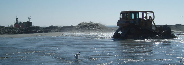 Why rising costs have left some Wilmington-area beach nourishment projects high and dry
Carolina and Kure beaches in New Hanover County and Oak Island in Brunswick County could be left waiting for sand due to rising dredging costs and a surge in demand for such projects nationwide
Some Wilmington-area beaches, recently covered by a rare snow storm, will soon again be a hive of activity as officials take advantage of the open environmental window − outside of sea turtle and shorebird nesting season − to pump fresh sand onto the vital economic engines for many coastal communities. The activity, however, will be muted this year, and that has officials in both New Hanover and Brunswick counties concerned.
What’s going on?
Call it the law of supply and demand. Beach nourishment is inherently expensive, requiring lots of pre-project planning and permit work and then securing an acceptable sand source that can be pumped onto a beach. If that borrow site is farther away than say a nearby inlet, like Wrightsville Beach and Carolina Beach mine for their projects, it will cost more to move the sand from the source to the beach. “Sources of sand are drying up in some places,” said Dr. Robert Young, director of the Program for the Study of Developed Shorelines at Western Carolina University. “Borrow areas don’t make sand. These are non-renewable resources. And as you creep offshore even a little, costs go up, often a lot. But another factor that’s helping send the cost of beach nourishment surging is the high demand for projects to rebuild beaches all along the Gulf and East coasts battered by recent hurricanes and the few number of American companies out there in the dredging business. “There are simply a limited number of companies out there that can do this kind of work, and competition is fierce because we’re literally trying to hold the line everywhere from Saco, Maine, to Padre Island, Texas, and that’s only a little bit of an exaggeration,” Young said. “When you have a lot of demand and not a ton of supply, the people who do work like this are really in the driver’s seat.”
What have been the impacts this year?
With prices coming in well above predictions, some Cape Fear-area beach towns are having to adapt and make painful decisions. In New Hanover County, the periodic federal nourishment of Carolina and Kure beaches is one that has fallen victim to the financial headwinds. The Pleasure Island project had an estimated cost of just under $20 million. But the only bid for the work the Army Corps of Engineers received came in at $37.5 million. In a letter to residents, Kure Beach Mayor Allen Oliver said the price differential was just too much to overcome this winter. “Getting additional bidders are slim and since the price was double the estimated project cost, the best possible solution is to postpone the event until next year,” the mayor said. “We should get better pricing and more bidders participating.” The delay means the two New Hanover beach towns will have to go longer than expected without a fresh injection of sand − a worry for officials and residents in a world where climate change is increasingly fueling stronger and bigger tropical storm systems. “This is not the most favorable situation for us and Carolina Beach, but honestly it is the most logical decision based on the lack of bidders and the cost of the single bid received,” Oliver said. In Brunswick County, Oak Island also is feeling the pain of higher prices and not enough competition. When the town opened bids up this fall for a large-scale, end-to-end beach nourishment project to take place this winter, the bids from two companies “were significantly above a feasible budget for the town, which was reflective of the fact that there is essentially no availability of dredging company equipment to conduct the project during that timeframe,” states a post on Oak Island’s website. The project is estimated to cost at least $40 million, with half of that covered by a one-time state grant. Bids for the same work to take place during the 2025-26 dredging window came closer to the town’s budget, and Oak Island officials are now in negotiations to see if the work can get done between mid-November and late April 2026. “If negotiations are not successful, the project will be rebid in 2025,” the town stated online. Now officials and residents have to hope the beach can hold out until then. Hurricane Isaias, which raked the Brunswick County shoreline nearly five years ago, chewed away a lot of the beach. Storms, king tides and gradual sea-level rise has since then added to the pain − not to mention the no-name storm and the remnants of Tropical Storm Helene that hit Brunswick County last September and October, respectively. Big beach projects aren’t the only ones getting caught up in the financial squeeze. A project put out to bid by the corps of engineers to dredge the shipping channel near the mouth of the Cape Fear River this winter and place the sand on Oak Island and Caswell Beach also came in 20% over estimates.
Is it all bad news?
At least one beach town in the Wilmington area will be seeing new sand this winter. This week, Surf City will begin pumping sand from Banks Channel on the Intracoastal Waterway side of the Pender County beach town onto its beach strand. The nearly $20 million project, which is expected to wrap up in late March, will nourish the town’s entire strand, adding an estimated 60 feet of beach from the Topsail Beach line to 1,000 feet north of the Surf City Fishing Pier. Town Manager Kyle Breuer said although Surf City only received one bid for the work, it was within the town’s estimates and the timing of when the dredging could take place within the fairly narrow fall/winter navigational window also worked. “We were very fortunate and very thankful,” he said. Breuer noted that not only will the project help nourish Surf City’s eroded beach but also piggyback on the earlier dredging of parts of Banks Channel done by Topsail Beach to improve navigation around the southern half of Topsail Island. The breakdown of the project’s cost is roughly $5 million from Surf City and about $14.5 million in funding coming through a one-time state grant.
What does the future look like?
Unfortunately, a lot like today − if not worse − for beach towns desperate to hold back the encroaching ocean, Western Carolina’s Young said. He said the pressures that are driving prices upward are only likely to increase as sea-level rise, more storms and increased development make shore protection efforts more frequent and necessary than ever along many parts of the country’s oceanfront. The new Trump administration’s stated goal of taking a fine-tooth comb to the federal budget and slashing a lot of discretionary spending also could leave many coastal communities hunting for new revenue sources outside of Washington just as dredging prices surge and the need for beach nourishment increases. “Beaches are not stable, they move, so the only future I see is one where costs are increasing because there’s only so much sand and we’re doing it more often and in more places,” Young said.
Read more » click here
Fauna & Flora –

NC State Native Plant Resources » click here
NC Sea Grant Coastal Landscapes » click here
New Hanover County Arboretum Native Plant Garden » click here
Audubon Native Plant Database » click here
Fauna & Flora » click here
Holden Beach recommended plant list – deer resistant & salt tolerant
Factoid That May Interest Only Me –
 There are 6 venomous snakes in North Carolina. Know what they look like.
There are 6 venomous snakes in North Carolina. Know what they look like.
If it’s spring, it’s time for us to remind you about some of the slithering neighbors you might encounter when you’re outdoors over the next several months. As the weather warms up in North Carolina, snakes start moving around, doing snakey things, and we are more likely to cross paths with them. They generally aren’t cause for much concern, but encounters can be a little scary for some (for the snakes as well as the people). It’s important to know that of the 38 species of snakes in North Carolina, the majority are nonvenomous and not aggressive toward people unless threatened. Arm yourself with knowledge. Learn about the venomous (sometimes incorrectly referred to as poisonous) snakes in our area, and how to distinguish them from the harmless ones.
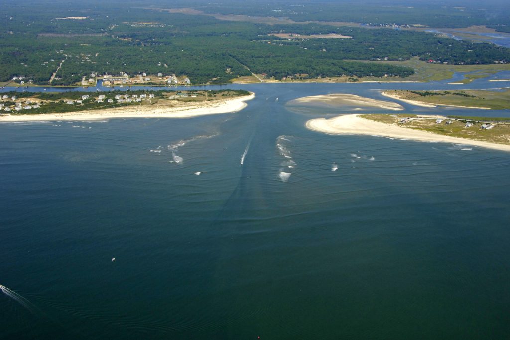 Lockwood Folly has a name as unique as its history
While boaters, beachgoers and coastal North Carolinians alike are familiar with the state’s well-trafficked waterways at the mouth of the Cape Fear River, there’s a less famous inlet with a unique name and the history to match. Lockwood Folly Inlet separates present-day Oak Island and Holden Beach. It is the endpoint of Lockwood Folly River, a 25-mile-long waterway that flows through central and southern Brunswick County before emptying into the inlet. In addition to being a productive outlet for boaters and fishermen, Lockwood Folly Inlet is a historical curiosity. Its location and name shed light on a period of North Carolina history overshadowed by the Lost Colony when 117 English settlers disappeared from Roanoke Island in the late 1580s, or the Albemarle settlements. The name of Lockwood Folly Inlet dates back to the 17th century to a mostly forgotten episode during the settlement of North Carolina. That episode, if successful, would have directly changed the fate of the colony and cured it of the “general economic backwardness,” according to historian Hugh Lefler, that defined its colonial reputation. Though Lockwood Folly Inlet is one of the more stable — its size and surrounding sandbars shift regularly — at only around 100 feet wide and sometimes only a few feet deep, the inlet doesn’t allow for sizable ships. As a result, it has not been the site of significant development over the past four centuries. The inlet was never a proposed site for a major dredging project or a new town like Beaufort or Roanoke. This limited development has likely been a reason why the inlet has kept its unique name for centuries. Much of the speculation about the inlet’s name has focused on the titular “folly” involved. One early theory was that the “folly” was a boat built so large that it could not sail out of the river. Louis T. Moore argued in a 1948 article for The State magazine, now known as Our State, that the name instead came from an attempted settlement or house by a man named Lockwood in the 18th century. Moore said that the homestead was destroyed by Native Americans he mistreated. As the author described, the “folly” resulted when “a man unable to control his temper or passions later was punished by being driven from the place he intended as his home.” While writers have worked hard to explain the second half of the inlet’s name, they have done much less to figure out the first half. Few people have researched who Lockwood actually was. Who was the man who built the ship that could not sail, or who made the failed settlement? In order to solve that mystery, one must go back to the earliest attempts to settle North Carolina, several of which have been almost lost to history. Moore posited that Lockwood Folly received its name in the early to mid-18th century, with Lockwood likely being a settler during that time. That period would have been after the 1720s when James Moore and his family first settled the Cape Fear River. The 1720s was the traditional start of European settlement in that area, the time when North Carolinians discovered the Cape Fear as a productive outlet to the ocean and began establishing some of their largest towns on it. Seeming to confirm this theory is the presence of Lockwood Folly on maps as early as the Edward Moseley map of 1733. Moseley held political appointments between 1715 and 1749. But Lockwood Folly is not just on the Moseley map, it is also on the Herman Moll map of 1708 and William Fisher’s “New Mapp of Carolina” dated to 1698. Both Moll and Fisher were London, England, mapmakers. The earliest map that contains a place named Lockwood Folly is the Ogilby map from around 1671. Taken from an influential book on the Americas published by British author John Ogilby, the map, “A new description of Carolina by the order of the Lords Proprietors,” was drawn decades before North Carolina’s first incorporated town and less than 10 years after the Lords Proprietor first received their Carolinas grant in 1663. It was one of the first maps drawn that focused primarily on North Carolina after the Lost Colony. Given many of the other details on this map, the most likely explanation for Lockwood Folly is that it was named after a man who was part of one of two lost British colonies of the Cape Fear area. The first, founded by explorer and Hilton Head’s namesake William Hilton, was settled by Puritans from New England in 1663. After the Puritans quickly abandoned the area, a somewhat more successful colony was formed by Barbadians led by the Yeamans and Vassall families. This Cape Fear colony, identified by historian Lindley Butler as “the first English town in the Carolina propriety,” included enslaved people from Africa and committed to producing food and goods to support Barbados. The colony lasted only three years before Native American attacks, a lack of supplies, and disasters in England led to its abandonment. Lockwood was not a known member of either the colonies or the initial William Hilton expedition. But of the dozen or so Cape Fear area names on the Ogilby map, several were from the Hilton and Yeamans expeditions. One of these was a region labeled Long’s Delight, likely named after Capt. Anthony Long, a leader of the Hilton expedition. Another was Turkey Quarters, an area noted by the Barbadians for its large number of turkeys. The Barbadian connection with Lockwood is bolstered by a story from James Sprunt’s influential 1914 book, “Chronicles of the Cape Fear River,” which combined historical narrative with local legends and stories. In one section, Sprunt, inspired by a 1734 travelogue, wrote of the inlet’s name, “One Lockwood, from Barbados, however, made a settlement farther to the south [of another proposed settlement up the Cape Fear], which the Indians destroyed, and hence the name to this day of ‘Lockwood’s Folly.’” While we may never know exactly who Lockwood was, the Barbadian lineage in Sprunt’s tale would appear to corroborate the theory that he may have been part of the Barbadian colony. The early settlement of the Cape Fear River is a fascinating what-if in North Carolina history. Cape Fear is a more stable and hospitable inlet to shipping than those by the Albemarle Sound. It might have quickly fostered towns like Beaufort in South Carolina or Norfolk in Virginia. Instead of existing for 50 years as an almost-forgotten backwater, North Carolina might have grown faster and with a more refined air had it been originally settled at Cape Fear. Along with Rocky Point, Lockwood Folly Inlet is one of the two last remnants on a North Carolina map of the Hilton and Yeamans colonies. Other names like Long’s Delight have disappeared from use and have no modern equivalent, illustrating the forgotten nature of the 1660s Cape Fear expeditions.
Read more » click here
Hot Button Issues –
Subjects that are important to people and about which they have strong opinions

Climate
For more information » click here.
There’s something happening here
What it is ain’t exactly clear
Hottest decade
The latest “State of the Global Climate” report has been released and the news is pretty dire: our world has just experienced its hottest decade. According to the World Meteorological Organization, 2024 was the hottest since record-keeping began and was likely the first time global temperatures exceeded 1.5 degrees Celsius above the baseline set in 1850-1900. Atmospheric concentrations of carbon dioxide, methane and nitrous oxide were at the highest levels in the last 800,000 years. Such record levels of greenhouse gases — along with the El Niño weather pattern — were mostly to blame for the higher temperatures.
Earth’s 10 Hottest Years Have Been the Last 10
A report from the World Meteorological Organization confirms that 2024 was the hottest year on record and the first year to be more than 1.5 degrees Celsius above the preindustrial era.
With the addition of 2024, yet another record-hot year, the past 10 years have been the 10 hottest in nearly 200 years of record-keeping, the World Meteorological Organization reports. “That’s never happened before,” said Chris Hewitt, the director of the W.M.O.’s climate services division. It marks the first time since record keeping began that all of the 10 hottest years have fallen within the most recent decade. 2024 was the single warmest year on record, surpassing even 2023’s wide lead over other recent years. The planet’s surface was approximately 1.55 degrees Celsius warmer than its average during a reference period that approximates the preindustrial era, from 1850-1900. The annual report from the W.M.O., a United Nations agency, includes input from dozens of experts and institutions from around the world and sheds further light on the record-breaking heat of 2024 and places it in the context of Earth’s long-term warming from climate change. The extra energy in the atmosphere and the oceans helped fuel climate-related disasters around the globe. Extreme weather events like drought, storms and wildfires displaced hundreds of thousands of people from their homes, the report says. Atmospheric levels of greenhouse gases released from fossil fuel combustion continue to rise. In 2024, the concentration of carbon dioxide hit amounts unseen in at least two million years, according to the report. Concentrations of two other important greenhouse gases, methane and nitrous oxide, reached levels unseen in at least 800,000 years. Homo sapiens, or modern humans, emerged around 300,000 years ago, so our species has never before experienced an atmosphere so laden with planet-warming greenhouse gases. When countries signed the Paris Agreement in 2015, they agreed to try to limit global warming to 1.5 degrees Celsius above preindustrial levels. “While a single year above 1.5 degrees C of warming does not indicate that the long-term temperature goals of the Paris Agreement are out of reach, it is a wake-up call that we are increasing the risks to our lives, economies and to the planet,” Celeste Saulo, the secretary general of the W.M.O., said in a statement. The new report estimates that long-term warming has reached 1.25 to 1.41 degrees Celsius above preindustrial levels, although the margins of error for some estimates extend beyond 1.5 degrees. The report authors estimate that last year, El Niño and other factors contributed an additional 0.1 or 0.2 of a degree of temporary warming. El Niño is a natural climate pattern that tends to slightly raise the overall surface temperature of the planet. Record warmth, however, continued into 2025, even through El Niño’s transition into the opposing pattern, La Niña. “It’s been really quite extraordinary to see that warmth continue for so long,” John Kennedy, the scientific coordinator and lead author of the report, said during a call with reporters. This warmth is especially apparent in the oceans, where key indicators of climate change are now accelerating. The oceans have so far absorbed around 90 percent of the additional heat trapped inside Earth’s atmosphere by greenhouse gases. The oceans’ heat content — a way to measure this warmth throughout different depths — also reached a record high last year. Over the past two decades, from 2005 to 2024, the oceans warmed more than twice as fast as they did from 1960 to 2005, according to the report. Increased ocean temperatures have had devastating consequences for marine life. By April 2024, warm-water corals had been bleached in every ocean basin where they grow. Global average sea-level rise also reached a record high in 2024, according to the report. The speed at which the seas are rising has also more than doubled in recent years: 4.7 millimeters per year in the past decade, from 2015 to 2024, compared with 2.1 millimeters per year from 1993 to 2002. The World Meteorological Organization’s work depends on international cooperation among its 101 member countries, including the United States. “If you look at how weather has progressed since the initiation of the W.M.O. in 1950, you can now see that you can have the forecast on your smartphone,” said Omar Baddour, the W.M.O.’s chief of climate monitoring. “You cannot believe how much collaboration is behind this.” Data from NASA and the National Oceanic and Atmospheric Administration, which recently lost hundreds of staff positions as part of the rapid, large-scale cuts to the federal bureaucracy the Trump administration undertook beginning earlier this year, are included in the W.M.O.’s new report.
Read more » click here

Flood Insurance Program
For more information » click here

National Flood Insurance Program: Reauthorization
Congress must periodically renew the NFIP’s statutory authority to operate. On March 14, 2025, the president signed legislation passed by Congress that extends the National Flood Insurance Program’s (NFIP’s) authorization to September 30, 2025.
Congress must now reauthorize the NFIP
by no later than 11:59 pm on September 30, 2025.

GenX
For more information » click here

Homeowners Insurance
For more information » click here

Hurricane Season
For more information » click here
Hurricane season runs from June 1 through November 30
Hurricane season is 3 months away. Will it be as active as last year?
What to know at this early stage.
One of the first things that tipped scientists off that 2024 would be an unusually active hurricane season: excessive ocean warmth in a key region of the Atlantic Ocean. But that’s just one of many factors different as this year begins. With the Atlantic hurricane season less than three months away, forecasters are making early efforts to understand how this year may differ from the last. And while specific forecasts for the number of hurricanes can’t be accurately made this far out, forecasters can look to planetary climate patterns for clues. At least two key differences suggest odds are lower for another extremely active season: For one, the tropical Atlantic isn’t as warm as it was last year. And a La Niña (known for cooling a vast swath of the Pacific Ocean) is not expected to form during the season. But it’s still early — and current conditions don’t entirely eliminate the odds of an overactive season. In the Atlantic Ocean, hurricane season runs from June through November, typically peaking in September. Last year, hurricane season was hyperactive, based on a metric called Accumulated Cyclone Energy. There were 18 named storms and five hurricane landfalls in the United States, including the devastating Hurricane Helene.
The Atlantic is cooler than last year
Among the many complex puzzle pieces that start to create a picture of hurricane season — including winds, air pressure patterns, Saharan Dust and monsoonal activity — sea temperatures are a key driver. Scientists look as an early signal to what’s called the Atlantic Main Development Region, or MDR, which extends from the Caribbean to the west, and to near Africa in the east. Sea surface temperatures in the MDR have a statistical relationship with hurricane activity. In 2024, there was excessive warmth in the MDR. But it’s not currently as warm as last year, nor is it forecast to be in a few months. When the MDR is cooler, it can contribute to atmospheric conditions that aren’t particularly conducive to lots of hurricanes. Forecasts for the MDR extend to July 2025, and they suggest that while seas in the region may be somewhat above-average, the Atlantic’s most unusual warmth will be located farther north. Comparing forecasts made for July of both years shows how much warmer the MDR was predicted to be in 2024 — a prediction that turned out to be correct. If the predictions hold true this year, that might reduce the odds for a season as active as 2024. Andy Hazelton, a physical scientist with the National Oceanic and Atmospheric Administration’s Environmental Modeling Center, said the cooling of the MDR is the biggest factor that has stood out to him so far. “It’s still pretty warm, especially in the Caribbean, but the subtropics (north of the MDR) look warmer overall right now,” Hazelton said. If the pattern were to continue, he said, it could put a cap on how active the season may be.
La Niña may be fading
During hurricane season, the Pacific and Atlantic oceans are more than distant neighbors — they’re connected by the atmosphere. What happens in one doesn’t stay there; it sends ripples to the other, shaping storm activity on both sides. One pattern that causes a Pacific-Atlantic ripple effect is known as the El Niño-Southern Oscillation (ENSO), which has three phases: El Niño, La Niña and neutral. El Niño is marked by warmer-than-average seas in the eastern Pacific, while cool seas are prominent there during La Niña. Neutral periods often occur during transitions between El Niño and La Niña, as sea temperatures temporarily become less anomalous. Early this year, the tropical Pacific entered a La Niña phase — but it’s not expected to last for much longer. The cool waters associated with La Niña can suppress rainfall and thunderstorm activity in the tropical Pacific. But as the atmosphere balances itself, increased rainfall and thunderstorm activity, as well as winds that are more conducive to hurricane formation, can occur in the tropical Atlantic. This is why, in addition to the record-warm Atlantic seas, forecasters were so concerned about the level of hurricane activity last year. But a period of weaker winds in the eastern Pacific this month has caused a substantial warming of the ocean to the west of South America. Because the winds have been less robust, a process known as upwelling — which happens when strong winds churn cool, subsurface waters to the surface — has slowed down. If the warming continues, it will put the Pacific in a much different state than it was heading into the last hurricane season. This year, a developing tongue of warm water in the eastern Pacific could have the opposite effect as it did last year, promoting rising air and more rainfall there, while having a drying effect on the Atlantic. However, predictions of El Niño and La Niña are not made equal. A phenomenon known as the “spring predictability barrier” can lead to less-skillful forecasts during spring in the Northern Hemisphere. “ENSO still has the spring barrier to cross,” Hazelton said. “But cool subsurface conditions and persistent trade winds suggest we probably won’t be getting a rapid flip or setting up for El Niño in the summer.”
The bottom line: It’s still early, but 2025 looks different
One thing can be said confidently at this point: So far this year, the elements that drive the Atlantic hurricane season look markedly different from 2024. The Atlantic Ocean is shaping up to have a different sea-temperature configuration than last year, with the most unusually warm seas sitting outside of the MDR. A marine heat wave — expansive blobs of unusual oceanic heat that are becoming more common in a warming climate — no longer covers the MDR, but remains active in the Caribbean and Gulf of Mexico, areas where hurricanes derive their energy from. In the Pacific, the door may be closing on La Niña as seas warm up in the east. But a full-fledged, hurricane-halting El Niño doesn’t look particularly likely, either. Hazelton said it’s possible there will be ENSO neutral conditions during peak hurricane season. These are some of the factors forecasters will be monitoring closely as hurricane season approaches. Seasonal outlooks of hurricane activity are typically released in April and May. And while the data may change, one thing is certain: It’s never too early to prepare, especially considering the United States experienced impactful landfalls from Hurricanes Beryl, Debby, Francine, Helene and Milton last year.
Read more » click here

Inlet Hazard Areas
For more information » click here
.
Lockwood Folly Inlet
For more information » click here.

Seismic Testing / Offshore Drilling
For more information » click here.

Offshore Wind Farms
For more information » click here
As NC wind energy projects advance, uncertainty rules
Wind projects that are leased, permitted or under construction in or near North Carolina are likely to survive buffeting by renewed wind energy skepticism from the Trump administration. Shortly after taking office in January, President Donald Trump issued an executive order barring new offshore wind leases and requiring reviews of existing and permitted wind projects. Although it was not targeting existing leases, industry supporters have questions about what rules, permits or projects it could impact and the potential for broader impacts through the workforce and manufacturing industries. “It’s not that companies are moving on as business as usual, but there’s so much uncertainty that they can’t just come to a screeching halt, and then all of this could change in five minutes,” Karly Lohan, Southeastern Wind Coalition’s senior Carolinas program manager, recently said in an interview with Coastal Review. “They have to keep going and figure this out as they go. And realistically, we’re probably not going to know an answer to a lot of those questions, and the true implications of this offshore wind executive action until … we know.” Lohan noted that the nonprofit coalition she represents is focused on educational outreach about wind energy and does not speak or act as a trade organization for the industry. A wind project off Kitty Hawk along the Outer Banks that’s owned by Avangrid Renewables and Dominion Energy is not yet under construction, but it still has active leases. Dominion Energy’s $9.8 billion Coastal Virginia Offshore Wind, or CVOW, project off Virginia Beach is going full speed ahead. The 2.6-gigawatt project is currently about half done and is expected to be completed on schedule by the end of 2026, according to company spokesman Jeremy Slayton. Duke Energy, along with Total Energies, has leased an offshore area off Southport for a wind farm known as Carolina Long Bay project, but it is in very early permitting stages. “We are still easily at least six or seven years away from construction for any of those projects,” Lohan said. The two land-based wind energy projects in North Carolina — Amazon Wind U.S. East in Elizabeth City, completed in 2017, and Timbermill Wind in Chowan County, completed in 2024 — will not be affected by the orders, Lohan said. Duke Energy has expressed interest in future land-based projects in North Carolina, but no information has been released about potential locations or plans, she said. While Dominion is working to complete its Virginia Beach project, it is keeping its CVOW-South, formerly the Kitty Hawk North project, on hold for the time being, Slayton, the company’s spokesman, said. “CVOW-South provides us with a potential option for additional offshore wind development,” he said in an email. “Our most recent long-term planning document, the Integrated Resource Plan, forecasts this project, if we pursue it, for the mid-2030s. At this time, we do not have a firm timeline or cost for developing this lease area.” Dominion Energy came to an agreement in July 2024 to purchase one-third of the Kitty Hawk North project, which is about 27 miles east of Corolla, the northern end of the Outer Banks, and about 38 miles southeast of the Sandbridge community in Virginia Beach. “Avangrid was willing to sell a portion of the project at a reasonable cost,” Slayton told Coastal Review at the time. “And we believe it was prudent to take advantage of this opportunity to meet the growing needs of our customers with clean energy and also help us achieve the requirements of the Virginia clean Economy Act, which calls for up to 5.2 gigawatts of offshore wind.” If developed, the project will connect to the grid for CVOW-South at a new substation at Corporate Landing in Virginia Beach, near Naval Air Station Oceana, he said. Katharine Kollins, president of Southeastern Wind Coalition, a nonprofit advocacy group, said that wind power production in the U.S. is behind the mature development of both offshore and onshore wind in Europe, but it has the capacity and resources to build a robust wind energy industry. “It requires economies of scale in manufacturing, all of the components it requires, economies of scale in construction and development and even in operations and maintenance,” she told Coastal Review recently. “And so, what the manufacturers have been saying to advocates in the industry for years is, ‘We need a solid pipeline of projects before we can commit a billion dollars to building a manufacturing facility in the U.S. that can then produce the major components, or an offshore wind turbine that would include your towers, your blades.’ Right now, I think the only thing that we can manufacture in the U.S. is foundations.” Like any energy production, wind energy is an equation of risk versus benefits, she said. And wind is economical, clean and safe, she added. “You don’t hear anything about wind spills,” she said. Yes, there are bird mortalities associated with strikes, but far, far less than the estimated one billion annual deaths from birds striking buildings. Kollins said the problem is uncertainty. “You know, uncertainty is not good for investment, and so if you have some significant political uncertainty, which makes it really hard for investors to move forward with any of those components that I was mentioning, whether in components, referencing manufacturing, referencing development, even thinking about leases. “Like, am I going to go pay $100 million to lease a square of ocean that, then I might have another presidential administration that says, ‘I don’t really like this?’ No thanks,” she said. “It does make it hard to overcome. This is an industry that should be nonpartisan.”
Read more » click here
Trump’s decision to pause offshore wind farms creates stormy waters for NC projects
The president’s move has brought into question the political and financial viability of future offshore wind farms, including two large projects for near-shore waters off Brunswick County
They are expensive to build, just finding their footing on this side of the Atlantic and have faced backlash from parties as varied as beachfront property owners and fishermen to coastal businesses and fossil fuel backers. But the U.S.’s still-young offshore wind industry has recently run into its biggest challenge of all, and one that could seriously destabilize the entire industry − including here in North Carolina: President Donald Trump. “I’d say it’s in critical condition,” said Dr. Brian Murray, director of the Nicholas Institute for Energy, Environment and Sustainability at Duke University. Trump’s move announced on his first day in office to cancel all future leases for offshore wind farms and block the federal government from issuing new permits for existing projects has effectively taken the wind out of the sails of several projects that were in the exploratory and planning stages, including two off Brunswick County and one off Kitty Hawk on the Outer Banks. The president also has asked federal officials to see if they could claw back any permits issued for existing projects. Trump’s executive order doesn’t stop the handful of offshore wind projects, primarily in the Northeast, that are already under construction from moving forward. But because building offshore wind farms is incredibly capital intensive, which much of that money coming at the front-end of the massive projects, stopping any additional offshore wind projects severely limits companies and utilities from taking advantage of economies of scale. Murray said the president also has hinted that he could seek to end the tax credits for renewable energy projects included in President Joe Biden’s Inflation Reduction Act, which was one of the big financial incentives that made many of these billion-dollar wind projects financially attractive in the first place. “Now there’s a big question if those tax credits will even materialize,” he said. Katharine Kollins, president of the Southeastern Wind Coalition, a nonprofit that advocates for wind energy development in the Southeastern U.S., said all of this political and financial uncertainty has left the industry largely in limbo and wondering what the future of offshore wind is in the U.S.
Ceding another industry to China?
Trump said he was taking the step to all-but end future offshore wind farms, which he railed against during his campaign, because the U.S. is facing an “energy emergency.” But to clean energy supporters and environmentalists, the president’s actions don’t add up. “To most folks in the energy industry, you don’t declare an energy emergency and then ensure your country can’t access one of the largest and easiest ways to generate electricity,” Kollins said, noting that it also up ends the “all of the above” approach to having a diverse mix of energy sources in your power portfolio. Ending federal support for offshore wind could also cede another renewable energy business sector that most economists believe will offer huge growth opportunities in the coming decades as fossil fuels run out and become more politically unpalatable to foreign countries, particularly China. Already, the West has all but given up in competing in the solar panel market, with China dominating the industry, and the Chinese are making great leaps and strides in dominating the electric vehicle market as American and European automobile manufacturers dither. That’s not to say the offshore wind industry doesn’t already have a sizeable economic footprint in the U.S. According to the Oceantic Network, which promotes the offshore renewable energy industry and associated supply chain, there’s a $25 billion supply chain in 40 states and at more than two dozen ports that supports the industry. One business that has been looking to get into the wind field is the N.C. State Ports Authority, which last year floated a plan to build a multi-use terminal that would support the state’s offshore wind and automotive industries at its Morehead City port. “These initial actions by the president have been incredibly harmful for the industry,” she said.
‘Delays cause more problems’
With federal support for renewable energy sources looking shaky at best, it isn’t known what that might mean for states and had planned on integrating lots of offshore wind into their future energy grids as a way of increasing their clean energy footprint and reducing their greenhouse gas emissions, which is the primary driver of climate change. According to Oceantic, as of the start of 2025 there are six offshore wind projects in operation or under construction delivering 5 megawatts of power to the nation’s grid, with state demand for another 116 megawatts to meet future power demands and clean energy mandates. In North Carolina, the latest iteration of the Carolinas Resources Plan approved last fall by the N.C. Utilities Commission calls for including up to 2,400 megawatts of offshore wind in Duke Energy’s portfolio by 2035 if a study due later this year shows it is feasible to move forward. Two of North Carolina’s major wind projects are planned for the waters just south of Brunswick County, with initial development and evaluation of the projects − including potential impacts to marine life like the high endangered North Atlantic right whale − already started. One of the Brunswick sites is leased to one of Duke’s unregulated affiliates, while the other is leased to France’s TotalEnergies. “We are continuing to evaluate all the Presidential Executive Orders that came out in January, including the executive order on offshore wind,” said Duke spokesperson Bill Norton. “We look forward to working with the new administration on constructive outcomes to ensure reliable and affordable energy for our growing customer base.” Kollins said the industry already was facing some headwinds because of inflationary pressures and the need to rework or cancel existing contracts with utilities that didn’t make the offshore projects financially viable. Now with Trump’s actions, some companies are abandoning projects or completely exiting the U.S. market. That, in turn, leaves businesses that support the industry with fewer potential customers and projects and wondering if they’ll be able to weather the storm until the political winds hopefully change in a couple years. “There’s a negative feedback loop with the supply chain, unfortunately,” Kollins said. Duke’s Murray said the political and regulatory uncertainties have put a big chill on the offshore wind industry. “It was already a challenging industry in many respects,” he said. “But what’s happened now will cause delays, and delays cause more problems.”
Read more » click here
Things I Think I Think –
 Eating out is one of the great little joys of life.
Restaurant Review:
The Dinner Club visits a new restaurant once a month. Ratings reflect the reviewer’s reaction to food, ambience and service, with price taken into consideration.
///// March 2025
Name: Ceviche’s
Cuisine: Panamanian
Location: 7210 Wrightsville Avenue, Wilmington NC
Contact: 910.256.3131 / https://www.wbceviche.com/
Food: Average / Very Good / Excellent / Exceptional
Service: Efficient / Proficient / Professional / Expert
Ambience: Drab / Plain / Distinct / Elegant
Cost: $26 Inexpensive <=20 / Moderate <=26 / Expensive <=35 / Exorbitant <=60
Rating: Three Stars
Ceviche’s is a Latin America seafood restaurant ranked #4 out of 666 restaurants located in Wilmington. It is located on Wrightsville Avenue, just before the bridge. They offer a creative Panamanian inspired menu specializing in serving ceviche which is a seafood dish popular in the coastal regions of Latin America. The dish is typically made from fresh raw fish marinated in citrus juices and spiced with various peppers. It is a very busy place, which is filled nearly every evening. The cuisine is fresh and interesting, it’s a nice change from the same old same old. We enjoyed the dining experience at this place, it was – Delightful!
Dining Guide – Local * Lou’s Views
Dining Guide – North * Lou’s Views
Dining Guide – South * Lou’s Views
Restaurant Reviews – North * Lou’s Views
Restaurant Reviews – South * Lou’s Views
Book Review:
Read several books from The New York Times best sellers fiction list monthly
Selection represents this month’s pick of the litter
 A DEATH IN CORNWALL by Daniel Silva
This is the twenty-fourth entry in the bestselling Gabriel Allon series, which chronicles the adventures of an art restorer, assassin and master spy, former chief of the Israel intelligence secret service, now retired. Gabriel comes out of retirement and joins forces with a team of operatives to track down a Picasso painting stolen by the Nazis and return it to its rightful owner. The story evolves into a complex conspiracy involving international stakes.
That’s it for this newsletter
See you next month
Lou’s Views . HBPOIN
. • Gather and disseminate information
. • Identify the issues and determine how they affect you
. • Act as a watchdog
. • Grass roots monthly newsletter since 2008