
Previously reported – February 2024
Inlet Hazard Areas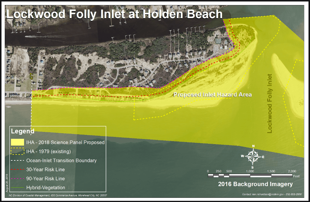
Previously reported – January 2019
New proposed rules could significantly impact real estate property values
Significantly expands area covered on the island
-
-
- by .4 miles on the east end
- by 1.7 miles on the west end
-
Coastal Resource Commission report to be presented at their February meeting
Panel Proposes Redrawn Inlet Hazard Areas
Read more » click here
Coastal Resources Commission
CRC Science Panel / Inlet Hazard Area (IHA) Delineation Update
Read more » click here
Previously reported – March 2019
CRC Advances New Inlet Hazard Maps, Rules
The North Carolina Coastal Resources Commission has approved preliminary boundaries and building rules at inlets. Though official adoption of the redrawn inlet hazard area, or IHA, maps and guidelines for development within those areas is still months away, the CRC’s decision last week puts the state one step closer to amending the current outdated maps.
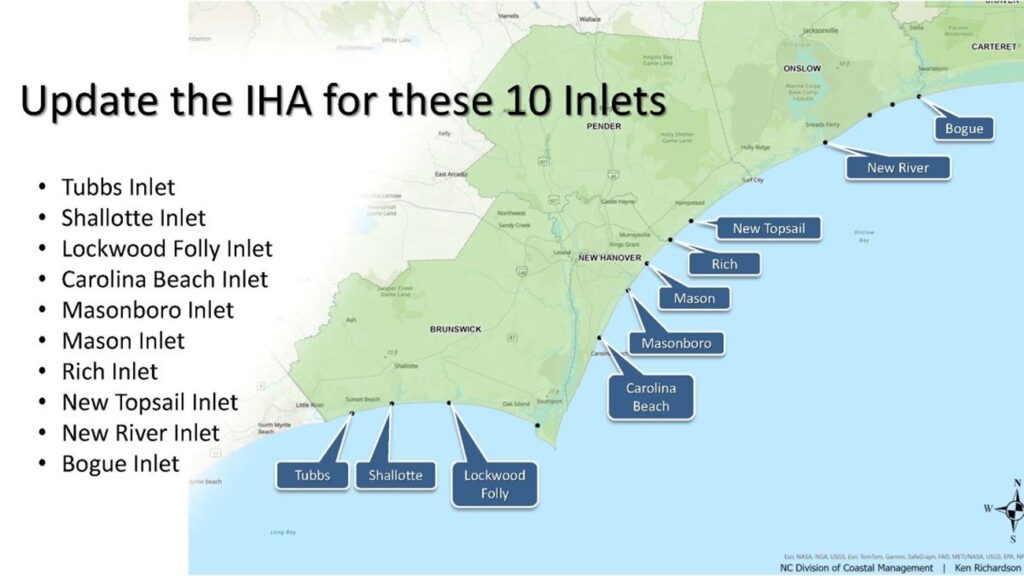
North Carolina Division of Coastal Management Director Braxton Davis told members of the commission at the quarterly meeting Thursday that the regulatory agency understands the revised maps are going to be a topic of controversy in the coastal towns at inlets. “These maps were done in 1981,” he said. “We have IHAs that don’t even capture some of these areas.” A little more than 2,900 acres of land is designated as IHA at 10 of the 19 active inlets in the state. The 10 are: Tubbs, Shallotte and Lockwood Folly inlets in Brunswick County; Carolina Beach, Masonboro, Mason and Rich inlets in New Hanover County; New Topsail Inlet in Pender County; New River Inlet in Onslow County; and Bogue Inlet in Carteret County. The CRC approved removing IHA designations at inlets where the adjacent land is undeveloped and owned either by the state or federalgovernment.
IHAs are defined as shorelines especially vulnerable to erosion and flooding where inlets can shift suddenly and dramatically. Inlets typically move over time in one of two ways. An inlet migrates, meaning it moves in one general direction, or it oscillates, wagging back and forth. A majority of the state’s inlets oscillate. Long-term erosion rates are about five times greater at oceanfront shorelines near inlets. The proposed maps expand current IHAs collectively by a little more than 1,359 acres while removing about 470 acres from existing boundaries at the 10 developed inlets. A majority of IHAs are being expanded under the proposed boundaries. The preliminary maps place an additional 152 acres and 243 structures within an ocean hazard area of environmental concern, or AECs. Ocean hazard AECs are defined as those that may be easily destroyed by erosion or flooding or may have environmental, social, economic or aesthetic values that make it valuable to the state.
Rules governing development within IHAs were established to control density and structure size along the shorelines affected by the dynamic waterways. The proposed setbacks have been established through years of work by the science panel that advises the CRC. The science panel studied historical shoreline data at each inlet, then used that information to predict erosion and accretion rates at those inlets. DCM has established building setbacks in the new boundaries based on the annual inlet erosion rates rather than the oceanfront erosion rates now. For some of the inlets, this method of calculation equates to no change in the current building setbacks. For others, the setbacks vary. Current rules do not allow lots about one-third of an acre in size to be subdivided. Residential structures of four units or fewer or nonresidential structures of less than 5,000 square feet are only allowed on lots within an IHA. The updated rules maintain the size limitation to no more than 5,000 square feet of heated space and remove restrictions on the number of units allowed in a structure. Larger structures that would be included in the new boundaries would be grandfathered under the rules.
North Topsail Beach Alderman Mike Benson expressed his concerns about condominiums at the north end of town that would be grandfathered in under the new maps. Benson told the commission during a public hearing on the proposed IHA map changes that the revised boundary at New River Inlet would include 11 buildings that are all larger than 5,000 square feet. If any of those buildings were to be destroyed in a hurricane or fire, Benson wanted to know if they could be rebuilt. DCM shoreline management specialist Ken Richardson clarified that structures between 5,000 and 10,000 square feet could be rebuilt to the same footprint. The owners of a structure greater than 10,000 square feet, such as Shell Island Resort in Wrightsville Beach, could request a variance from the CRC to rebuild. Richardson said he will turn over DCM’s recommended changes to the state Office of State Budget and Management for review. Once that office confirms its findings, a series of public meetings will be held where the public will get an opportunity to comment on the maps and rules. Richardson said he hopes those meetings will kick off some time in the spring and that revised maps are adopted by year’s end. If adopted, the new IHA boundaries would be updated every five years.
Read more » click here
Previously reported – April 2019
Development rules near inlets have been basically the same since 1981.
This year that could change
Over 1,000 inlet-adjacent acres in the Cape Fear region could soon be subject to an additional set of state development regulations. At the same time, 500 acres could be removed from the same regulatory designation designed to limit risky development near dynamic inlet shorelines.
Read more » click here
Holden Beach Property Owners Association / Inlet Hazard Areas
The Coastal Resources Commission (CRC) has established new boundaries for Inlet Hazard Areas on each end of the island, greatly increasing the number of properties that fall within this designation. The CRC determined the new IHA boundaries based on historic vegetation line data. The CRC sent the rules to the State for review. After review there will be public comment before the rule are put in place.
Inlet Hazard Areas (IHAs) are sections of islands that are more vulnerable to erosion due to the impact of the inlets. The new maps show Holden Beach will be hit hard, especially on the West End.
The West End currently has 15 lots in the IHA, which will go up to 173 lots, and includes all the oceanfront properties from roughly Sailfish to the end of the island. The area will increase from 290.5 acres to 569.3 acres, almost double in size. This will be the largest IHA in the state.
The East End will also see changes. The IHA there is 64 acres and will jump to 189.5 acres – an almost 200% increase in size. Currently, there are 52 lots in the IHA, which will increase to 156.
Visit our website to see the maps and determine if your property is impacted by the new IHA boundaries.
What Does It Mean?
1) Structures (residential or commercial) will be limited to 5000sf of heated space. Existing larger structures would be grandfathered and could be rebuilt if destroyed.
2) Insurance is impacted for homes in an IHA.
3) New development would require lots with a minimum of around one-third acre.
4) The ability to have a concrete slab under a home might be restricted in some cases, as impervious surfaces at ground level may not be allowed
It is not clear what impact the changes will have on property values and the Town’s tax base – if any.
Previously reported – October 2019
Public Can Weigh in on Inlet Hazard Updates
The North Carolina Division of Coastal Management will host of public meetings on proposed updated inlet hazard area boundaries and building rules within those areas, after a series of hearings about the updated erosion rates used to determine the proposed IHAs. Everyone from coastal property owners to developers will get a chance to weigh in on the preliminary boundaries, which were approved earlier this year by the state Coastal Resources Commission, or CRC.
The CRC unanimously approved the fiscal analysis and rule amendments to the proposed inlet hazard areas, or IHAs, Wednesday during the commission’s quarterly meeting held in Wilmington. That analysis, approved Aug. 30 by the Office of State Budget and Management and state Department of Environmental Quality, details the number of structures removed from and added to be included within the boundaries. Currently there are 750 structures within IHAs, which are defined as shorelines especially vulnerable to erosion and flooding where inlets can shift suddenly and dramatically. Of those structures, 307 would be removed from ocean hazard areas, or OHAs, under the proposed boundary revisions. Any of those homes built before 1980 would, for the first time in nearly 40 years, not be included inside of these boundaries, according to Ken Richardson, shoreline management specialist with Division of Coastal Management.
OHAs are made up of three areas of environmental concern, or AECs: IHAs, ocean erodible areas, or OEAs, and unvegetated beach. The proposed updated boundaries would include a total of about 930 structures within IHAs. Of those, 219 would be new to the OHA, meaning this would be the first time they would be within an IHA or OEA. Properties newly exempt from the OHA will have less stringent development and redevelopment rules than those within an IHA. AECs are identified as areas that may be easily destroyed by erosion or flooding or may have environmental, social, economic or aesthetic values that make it valuable to the state. More than 2,900 acres of land is within IHA boundaries at 10 of the 19 active inlets in the state. The 10 are: Tubbs, Shallotte and Lockwood Folly inlets in Brunswick County; Carolina Beach, Masonboro, Mason and Rich inlets in New Hanover County; New Topsail Inlet in Pender County; New River Inlet in Onslow County; and Bogue Inlet in Carteret County.
A majority of IHAs are being expanded under the proposed boundaries, which include building setbacks that vary from inlet to inlet. The science panel that advises the CRC has for years worked on the proposed setbacks, studying historical shoreline data at each inlet and using that information to predict erosion and accretion rates at those inlets. Building setbacks in the new boundaries are set based on annual inlet erosion rates rather than oceanfront erosion rates. For some of the inlets, this method of calculation equates to no change in the current building setbacks. For others, the setbacks vary. Setback requirements will not change for a little more than 730 properties in IHAs. Fifty-seven properties will have decreased setback requirements, while setback requirements will increase for 137 properties. Under the proposed changes, boundaries and setbacks will be reviewed every five years.
Richardson told the CRC last week that OEAs and IHAs are not factors in the calculation of flood insurance premiums. The proposed IHA updates “do not have an immediate negative or positive impact” to community National Flood Insurance Policy’s Community Rating System, a voluntary program that incentivizes communities that go above and beyond the minimum floodplain management requirements, according to the fiscalanalysis.
The updated rules maintain the structure size limitation to no more than 5,000 square feet of heated space and no more than one unit per 15,000 square feet of land area. Homes and businesses that exceed the size limit and would be included in the new boundaries would be grandfathered under the rules. IHA rules apply to property owners who want built a new structure or replace one that has been damaged and requires more than 50% repair.
If approved, the amended boundaries and rules may be adopted by early next year.
Public hearings on the updated erosion rates use to determine the proposed IHAs will be held at the following times and locations:
-
- 10 a.m. Oct. 3, Northeast Library, 1241 Military Cutoff Road, Wilmington.
- 2 p.m. Oct. 3, Harper Library, 109 W. Moore St., Southport.
- 1:30 p.m. Oct. 8, Ocracoke Volunteer Fire Department, 822 Irvin Garrish Highway, Ocracoke.
- 10 a.m. Oct. 9, Nags Head Board of Commissioners room, 5401 S. Croatan Highway, Nags Head.
- 2:30 p.m. Oct. 9, Outer Bank Center for Wildlife Education, 1160 Village Lane, Corolla.
- 10 a.m. Oct. 15, Surf City Welcome Center, 102 North Shore Drive, Surf City.
- 3 p.m. Oct. 15, Sneads Ferry Library, 1330 N.C. 210, Sneads Ferry.
- 3 p.m. Oct. 17, North Carolina Division of Coastal Management, 400 Commerce Ave., Morehead City.
Read more » click here.
Previously reported – November 2019
 The Holden Beach Property Owners Association (HBPOA) has been monitoring the proposed changes to the Inlet Hazard Area (IHA) boundaries on the east and west ends of our island. The proposed IHA will impact more than 200 property owners on the west end of our island by placing new restrictions on what they can build (or rebuild) on their property.
This is the highest number of structures in any IHA in the state and adding this many properties to an IHA on our island will have a significant impact not just to the impacted property owners, but to our overall tax base as well. We don’t understand the rationale behind this change, since the west end of Holden Beach has been continuously accreting for decades, as documented in surveys by the Town’s engineer. The Inlet Hazard Area Method (IHAM) does not take any of this into account.
Ken Richardson reported at the NCBIWA conference that public hearings on the IHA changes will begin next month and comments will be closing at the end of January. We are trying to notify our impacted property owners so they can provide input, but there is no notice of the hearing on the Division of Coastal Management website, only scientific documents.
We need your help with informing our property owners. Given the significance of the changes to the IHA and the short timeframe for input occurring over the holidays, the HBPOA would like to conduct a public hearing or information session to inform our members about this significant potential impact to their property. Your assistance with conducting this session would be greatly appreciated.
Soon to be Commissioner Brian Murdock sent e-mail, this was the response from Braxton C. Davis, Director – NC Division of Coastal Management / Department of Environmental Quality
I understand your concerns and agree that the timing of the hearing is probably not good for many who are planning to travel for the holidays. I also appreciated the comments made by Tim Evans on behalf of the Town at our meeting this week. Our December hearing has already been advertised in the newspaper, so we will need to move forward with it, but we are absolutely willing to come back in January to hold a “workshop” so that we can try and clarify the overall process and background on the proposed changes, and to make sure we get additional public comments to take back to the Commission at their meeting in February. We will also begin a 60-day public comment period on Dec. 2 (ending late January) – it will be announced in the NC Register, and written comments can be sent to me at the office address below or via email.
Previously reported – December 2019
The Holden Beach Property Owners Association (HBPOA) has been monitoring the proposed changes to the Inlet Hazard Area (IHA) boundaries on the east and west ends of our island. The proposed IHA will impact more than 200 property owners on the west end of our island by placing new restrictions on what they can build (or rebuild) on their property.
This is the highest number of structures in any IHA in the state and adding this many properties to an IHA on our island will have a significant impact not just to the impacted property owners, but to our overall tax base as well. We don’t understand the rationale behind this change, since the west end of Holden Beach has been continuously accreting for decades, as documented in surveys by the Town’s engineer. The Inlet Hazard Area Method (IHAM) does not take any of this into account.
Ken Richardson reported at the NCBIWA conference that public hearings on the IHA changes will begin next month and comments will be closing at the end of January. We are trying to notify our impacted property owners so they can provide input, but there is no notice of the hearing on the Division of Coastal Management website, only scientific documents.
We need your help with informing our property owners. Given the significance of the changes to the IHA and the short timeframe for input occurring over the holidays, the HBPOA would like to conduct a public hearing or information session to inform our members about this significant potential impact to their property. Your assistance with conducting this session would be greatly appreciated.
Soon to be Commissioner Brian Murdock sent e-mail, this was the response from Braxton C. Davis, Director – NC Division of Coastal Management / Department of Environmental Quality
I understand your concerns and agree that the timing of the hearing is probably not good for many who are planning to travel for the holidays. I also appreciated the comments made by Tim Evans on behalf of the Town at our meeting this week. Our December hearing has already been advertised in the newspaper, so we will need to move forward with it, but we are absolutely willing to come back in January to hold a “workshop” so that we can try and clarify the overall process and background on the proposed changes, and to make sure we get additional public comments to take back to the Commission at their meeting in February. We will also begin a 60-day public comment period on Dec. 2 (ending late January) – it will be announced in the NC Register, and written comments can be sent to me at the office address below or via email.
Inlet Hazard Area Changes
If your property is west of Sailfish or East of Blockade Runner, you should be aware of the proposed changes. For more information and the maps, check out the Hot Topics page on the HBPOA website.
For more information » click here
From the Mayor’s Desk
Inlet Hazard Area Changes
The Coastal Resources Commission is in the process of developing new rules that have the potential to greatly impact several hundred lots at Holden Beach. Please review the information below for an executive summary prepared by the Business Alliance for a Sound Economy (NCBASE) complete with details of the rules, dates/times of public hearings, maps of properties affected and contact information for those needing to receive feedback on the proposed changes.
Please take the time to review, attend the hearings if possible and provide your comments/concerns.
Information from NCBASE:
The NC Division of Coastal Management is holding public hearings and accepting feedback regarding the proposed changes to the Inlet Hazard Areas (IHA). The proposal put forth will 1) greatly expand inlet hazard areas as well as 2) significantly change in the way that setbacks are measured in these areas. If approved by the Coastal Resources Commission, this proposal will impact thousands of acres of coastal land and thousands of parcels and structures in our region.
The proposed rules can be found in the attached document (click here) on pages 16. On pages 6 – 7, you can see the breakdown (structure, acres) by community.
Here are some additional links to resources related to the IHA update:
-
- Inlet Hazard Area Update Report The CRC Memo which includes the basis for the rules, also includes new maps starting on page 103.
- Proposed IHA Erosion Rate Setback Factor Report
- The Division’s Interactive Online Map Viewer (click on data layers to turn on/off and get more info)
Please review the new maps and new rules. Then make plans to attend the public hearings and make your voice heard.
Public Hearings and Comment Period:
Public hearings start on December 17, 2019 in Brunswick County and will be held in a number of coastal locations through mid-January. The full schedule is at the end of this document. Written comments, questions and feedback will also be accepted. Provide written comments, questions and feedback via email to DCM Director Braxton Davis (braxton.davis@ncdenr.gov) and/or Ken Richardson (ken.richardson@ncdenr.gov).
Comments will be accepted through January 31, 2020. Depending on breadth of comments, the issue could go to the Coastal Resources Commission at the February 2020 meeting and have an implementation date of April or May 2020.
Over the same period, the state of North Carolina and individual communities have continued to proactively advance coastal management strategies including the creation of a shallow draft inlet fund, the permitting of terminal groins and investment in continued coastal storm damage reduction projects to enhance our coastal infrastructure.
Concerns:
-
-
- The impacts of the expanded Inlet Hazard Areas and revised setback calculations will be widespread and significant.
- Has DCM notified property owners that will be in the expanded Inlet Hazard Area?
- Has DCM notified property owners in the current Inlet Hazard Area that the setback factors are changing?
-
-
-
- The Proposed IHA Rule Changes and new setback calculations could result in a taking of private property if they completely prevent development of a parcel. For example, if a lot is 150′ deep and its setback goes from 60′ to 240′-it is unbuildable.
-
The Proposed IHA Rule Changes may increase the CRC’s exposure to takings claims. Such claims may arise because the Proposed IHA Rule Changes and setbacks would prohibit development within areas in which development is not currently prohibited. They may also arise where property owners who acquired or held their property with the expectation of being able to develop at a certain intensity are not satisfied with the limited development potential that the Proposed IHA Rule Changes would permit in protectedIHAs
-
-
- The grandfathering provisions need to be expanded. The grandfathering protection the CRC Memo says would apply to all lots under 15,000 sq.ft. is not actually included in the Proposed IHA Rule Changes.
-
The CRC Memo states that the Proposed IHA Rule Changes include provisions to grandfather all existing structures within the new IHAs as well as all lots under 15,000 square feet, platted after July 23, 1984 or before the effective date of the Proposed IHA Rule Changes, with respect to density restrictions. However, there is no language in the Proposed IHA Rule Changes that expressly grandfathers such lots.
-
-
- The cumulative effect of the Proposed IHA Rule Changes is to make an additional 1,819.7 acres of coastal land subject to development restrictions-in addition to expanding restrictions on existing parcels in the IHA. This will impact property values in a range of affected communities.
-
-
-
- The Proposed IHA Rule Changes imply a causal connection between the size of a structure, the number of units in a structure, and the size of a lot and the risk of erosion, flooding, and other adverse effects of sand, wind and water associated with dynamic ocean inlets. It is unclear, however, how the size of a home, the number of units, or size of a lot has any causal relationship to the risk of realizing hazards associated with dynamic ocean inlets.
-
-
-
- The revised rules will negatively impact property values and complicate potential sales and financing as a result of the “new” nonconforming status of the structures and parcels identified in the CRC Memo. To help alleviate the concern about making existing structures nonconforming, CRC could include a provision in the Proposed IHA Rule Changes that would allow for reconstruction of nonconforming structures and structures on nonconforming lots without the need to come into compliance with currentrules.
- Table 3 of the CRC Memo shows that, under the Proposed IHA Rule Changes, the number of lots within IHAs that do not meet the 15,000 square feet minimum lot size requirement more than doubles, from 894 lots to 1,805 lots.
- Similarly, Table 2 of the CRC Memo shows that, overall, the Proposed IHA Rule Changes would increase the number of structures with heated area greater than 5,000 square feet within or intersecting IHA boundaries from 24 to 41. Under the Proposed IHA Rule Changes, all such structures would be non-conforming with respect to the proposed maximum floor area allowance.
-
Public Hearing Schedule / Inlet Hazard Area Update
Brunswick County December 17, 2019 10:00 a.m.
Brunswick County Government Complex
30 Government Center Drive, NE
Bolivia, NC 28422
New Hanover County December 17, 2019 3:00 p.m.
New Hanover County Government Center
230 Government Center Drive
Wilmington, NC 28403
Onslow County December 18, 2019 10:00 a.m.
Sneads Ferry Library
1330 Highway 210
Sneads Ferry, NC 28460
Pender County December 18, 2019 3:00 p.m.
Assembly Building
720 Channel Blvd.
Topsail Beach, NC 28445
Carteret County January 7, 2020 3:00 p.m.
NCDCM
400 Commerce Avenue
Morehead City, NC 28557
Hyde County January 8, 2020 10:00 a.m.
Community Center – Multipurpose Room
30 Oyster Creek Road
Swan Quarter, NC 27885
*broadcast simultaneously to Ocracoke Island:
Ocracoke Community Center
999 Irvin Garrish Highway
Ocracoke, NC 27960
Dare County January 14, 2020 11:00 a.m.
Town of Nags Head
Board of Commissioners Room
5401 S. Croatan Highway
Nags Head, NC 27959
State’s Inlet Hazard Plan Criticized at Hearing
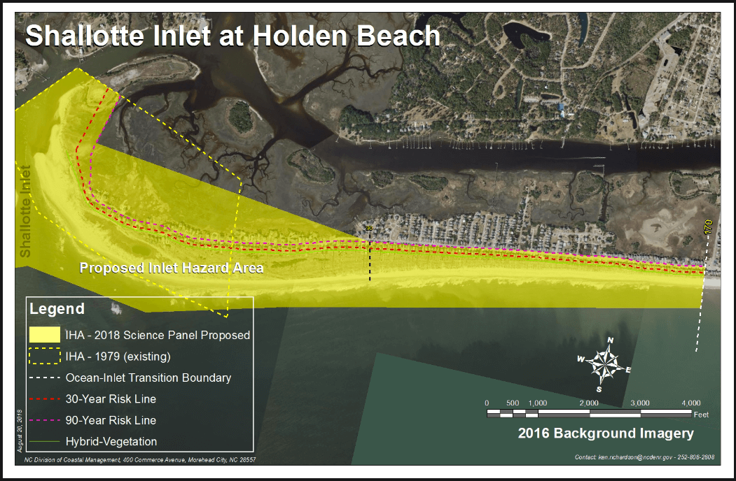
Holden Beach is taking the state Division of Coastal Management to task for its proposal to expand the western end of the island’s inlet hazard area. During the first in a series of public meetings the division is hosting through January, a small group of Holden Beach residents and the town’s planning director on Tuesday morning questioned a state official as to why the preliminary boundary at Shallotte Inlet stretches eastward for about 2 miles from the end of the island that is accreting. “I really have concerns just about how you came up with these boundaries,” said Vicki Myers, resident and chair of the town’s Inlet and Beach Protection Board. “I think your math is wrong.” The preliminary boundary encompasses a little more than 200 structures, nearly four times the 51 structures in the current inlet hazard area. “This is a huge issue,” said Holden Beach Property Owners Association President Tom Myers. “To look at these numbers it makes it look like it’s the most dangerous place in the state. Just looking at it makes no sense that our west end of the island has the most houses in an inlet hazard area in the state.” The Myerses, who are married, do not live in the current or proposed inlet hazard area, or IHA, but said expanding the area at the western end, which has been accreting since the 1970s, does not make sense.
Developed inlets
IHAs are defined as shorelines especially vulnerable to erosion and flooding where inlets can shift suddenly and dramatically. Shallotte Inlet is one of 19 active inlets in the state. Ten of those are called developed inlets. A little more than 2,900 acres at the 10 developed inlets are designated as IHAs. Those inlets include Tubbs, Shallotte and Lockwood Folly in Brunswick County; Carolina Beach, Masonboro, Mason and Rich in New Hanover County; New Topsail and New River in Pender County; and Bogue Inlet in Carteret County. Discussions and attempts to update IHA boundaries, which were first drawn in the late 1970s, go to back to 1998-99, when members of the first-appointed science panel suggested to the commission that the boundaries were outdated. Current IHAs were drawn based on the historic migration of the inlet shoreline. To establish the proposed updated IHAs, the science panel is using the hybrid vegetation line, or landwardmost position of the historic vegetation line, to determine boundaries. The proposed maps expand current IHAs collectively by a little more than 1,359 acres while removing about 470 acres from existing boundaries at the 10 developed inlets. Inlets typically move over time in one of two ways: An inlet migrates, meaning it moves in one general direction, or it oscillates, wagging back and forth. A majority of the state’s inlets, including Shallotte Inlet, oscillate. In its recommendations released to the Coastal Resources Commission earlier this year, the commission’s science panel explained that the historic repositioning of the outer bar channel from the southwest to the southeast reshaped the ebb-tide delta and its effect on the adjacent oceanfront shorelines on Holden and Ocean Isle beaches. The ebb channel has generally aligned in a southeast/east-southeast direction since the late 1960s, which has allowed sand to accrete at the western end of Holden Beach. During this same time, Ocean Isle’s oceanfront shoreline at the inlet has experienced chronic, long-term erosion. If the ebb channel were to re-orient itself again toward Ocean Isle, then Holden Beach would erode, according to the science panel. Holden Beach Planning and Inspections Director Tim Evans said the data indicate the inlet essentially stabilized in the 1970s. “Our vegetation line is constantly growing,” he said. “I think that Holden Beach really needs to be looked at again, especially where the original inlet hazard area was. I just don’t see how we can believe in the science.” The new proposed boundaries come with updated rules, which include the current limit that structures within an IHA can be built no larger than 5,000 square feet of heated space and no more than one unit per 15,000 square feet of land area. Homes and businesses that exceed the size limit within the new boundaries would be grandfathered under the new rules. Existing structures destroyed or damaged, requiring more than 50% repair, can be rebuilt regardless of size or density as long as the structure meets the setback requirements within the IHA. Setbacks vary in each area. If a structure does not meet the setback requirements, a structure that meets current grandfathering rules may apply. Those rules include being built before Aug. 11, 2009, meeting minimum setbacks, staying within the original footprint and rebuilt as far landward on a lot as possible. The current preliminary boundary at the west end of Holden Beach stretches about 2 miles, Evans said. He argued that a major storm, not inlet erosion, could damage and destroy the more than 200 homes within the proposed IHA. If those homes cannot be rebuilt because they do not meet setback conditions, that would have a significant economic impact to the town, Evans said.
More hearings scheduled
Public hearings are being hosted in counties where there are developed IHAs.
Hearings were held in New Hanover, Pender and Onslow counties Tuesday andWednesday.
The remaining hearings are as follows:
-
- Jan. 7 – N.C. Division of Coastal Management office, 400 Commerce Ave., Morehead City.
- Jan. 8 – Community Center, Multipurpose Room, 30 Oyster Creek Road, Swan Quarter, and broadcast simultaneously to Ocracoke Island at the Ocracoke Community Center, 999 Irvin Garrish Highway.
- Jan. 14 –Nags Head Board of Commissioners room, 5401 S. Croatan Highway, NagsHead.
Public comments may be submitted to the Division of Coastal Management through Jan.31, 2020.
Public comments will likely be presented to the Coastal Resources Commission at its February meeting next year. If the commission adopts the new boundaries, those may go into effect between April and May.
Read more » click here
Previously reported – January 2020
Inlet Hazard Update Workshop
The state Division of Coastal Management will hold a workshop for the Town of Holden Beach to review proposed Inlet Hazard Area boundary updates and associated Coastal Resources Commission rule amendments. The workshop is scheduled for Thursday, January 16th at 2:00 p.m. in the Town Hall Public Assembly. This is important information for our community. Please make plans to attend this workshop.
Urgent Action Required
The Division of Coastal Management will be conducting a workshop at Town Hall Thursday, January 16th, at 2:00PM to review the proposed changes to the Inlet Hazard Area boundaries and rules.
The HBPOA Board has passed a resolution in opposition to these proposed changes. We have also engaged legal counsel to represent property owner interests relative to these changes.
We are very concerned that the new IHA will have significant negative impacts to all property owners. Property owners in the IHA will be restricted with regards to what they can build or rebuild on their property. The changes could reduce the value of these properties, which would impact all other property owners by shifting the taxburden.
We are recommending the following actions:
-
-
- Everyone should send comments to Braxton.Davis@ncdenr.gov and/or Ken.richardson@ncdenr.gov.
- Click here to determine if your property will be in or near the new IHAs. You can also determine the potential impact to your property by viewing the lines that will be used for calculating setbacks. For more information on how to use the mapping tool click here or go to our Hot Topics page.
-
The comment period closes on January 31st so now is the time to provide your input. You can reference our Resolution with regards to the issues we believe to be significant. You can also check our Hot Topics page for additional information.
Inlet Hazard Update Workshops Set
The first Inlet Hazard Areas, or IHA, in the state were developed in 1978 to recognize that shorelines adjacent to inlets are more dynamic than those along the oceanfront and some inlets since have had significant changes, according to the Inlet Hazard Area Boundary, 2019 Update. An IHA, a designated Area of Environmental Concern, is a natural-hazard area vulnerable to erosion, flooding and other adverse effects of sand, wind, and water because of its proximity to dynamic ocean inlets.
Currently there are 750 structures within IHAs, or shorelines especially vulnerable to erosion and flooding where inlets can shift suddenly and dramatically. Of those, 307 would be removed from ocean hazard areas, or OHAs, under the proposed boundary revisions. The proposed updated boundaries would include a total of about 930 structures within IHAs and would include 219 properties new being included in an ocean hazard area, according to the report.
Read more » click here
Inlet Hazard Area Workshop 01/16/20
The state Division of Coastal Management held a workshop for the Town of Holden Beach to review proposed Inlet Hazard Area boundary updates and associated Coastal Resources Commission rule amendments.
Ken Richardson –NC Division of Coastal Management
“At a Glance”
. 1. Boundary: Updated Inlet Hazard Areas
. 2. Rule: All structures treated equally
.. • Structure size: 5,000 sq. ft.
. . • Density: 1 unit per 15,000 sq. ft. of land
. 3. Rule: setback based on inlet erosion rates
. 4. Rule: Grandfathering rules still apply
Review presentation » click here
IHA Takeaways:
-
-
- CRC’s Science Panel on Coastal Hazards used a methodology which involve possibilities, not certainties.
- They seem convinced that the west end will have serious erosion issues that are influenced by the inlet
- The IHA is based on the worst-case scenario
- One has to ask: What is happening in the inlet, other than that OIB is building a terminal groin there?
- THB is penalized for the west end accretion in model based on standard deviationformula
- Realtors and contractors both felt very strongly that this designation would be like a Scarlett letter
- The change could have a significant negative impact for the entire island
- The word HAZARD paints too negative a picture, they should consider a change to use RISK instead
- Ken requested and wants community input and it would carry more weight coming from the Town
- He recommended that the THB send them something summarizing the communitiescomments
- The comment period closes on January 31st
-
There were eighty-seven (87) members of the community in attendance
 .
.
Breaking News
Public Comment period on the proposed rulemaking to update IHA has been extended to March 2nd
Previously reported – February 2020
Public Comment Period Extended
The N.C. Coastal Resource Commission is extending the public comment period until March 2nd for proposed rulemaking intended to update Inland Hazard Area boundaries and associated development rules. The original comment period was scheduled to end on January 31st.
The proposed rules and related documents are available on the DEQ website.
Please take the time to familiarize yourself with this very important matter and send comments in.
Written comments may be mailed to:
Braxton Davis, Director
Division of Coastal Management
400 Commerce Avenue
Morehead City, NC 28557
Comments may also be emailed to DCMcomments@ncdenr.gov.
Please list “Inlet Hazard Area updates” in the subject line.
Town Website
Inlet Hazard Area Comment:
The N.C. Coastal Resource Commission extended the public comment period until March 2nd for proposed rulemaking intended to update Inland Hazard Area boundaries and associated development rules. The proposed rules and related documents are available on the DEQ website. The Town has submitted a letter in opposition of the proposed update. Click here to see the letter. Applied Technology & Management, the Town’s consulting coastal engineer also provided comments. Click here to view the letter. It is important that individuals take the time to familiarize themselves on the topic and submit their own letters.
For more information » click here
State Extends Time For Input On New IHAs
The state Division of Coastal Management has extended the public comment deadline on proposed redrawn inlet hazard area boundaries and building rules within them. Public comments may be submitted through March 2, an additional month past the original Jan. 31 deadline. Ken Richardson, a shoreline management specialist with the division, told members of the North Carolina Coastal Resources Advisory Council, or CRAC, on Wednesday that the division had received a hefty amount of comments about the proposed boundaries and rules. Given the volume of comments the state had already received, Richardson said a staff summary of that public feedback would be presented to the Coastal Resources Commission, or CRC, which will likely discuss the proposed changes during its April meeting in Manteo. “This is just kind of the start,” he said. The CRC may discuss in April issues raised by the public, including proposed grandfathering dates related to rebuilding after storms, proposed limits on the size of structures built within the boundaries and whether the method established to draw the new boundaries accurately predicts erosion rates at the state’s developed inlets.
Spencer Rogers, a member of the Science Panel and CRAC, told fellow council members Wednesday that there are problems with some of the proposed changes. The most serious, he said, is that erosion rates are severely underestimated at some of the inlets under the proposed rules. Current Inlet Hazard Areas, or IHAs, were drawn based on the historic migration of the inlet shoreline. Under the proposed changes, the hybrid vegetation line, or most landward position of the historic vegetation line, is used to establish setbacks within inlet hazard boundaries. Inlet hazard areas are defined as shorelines especially vulnerable to erosion and flooding where inlets can shift suddenly and dramatically. Erosion rates are more similar and evenly parallel along a straight shoreline. That’s not the case at inlet shores, which curve around. Including the average oceanfront erosion shoreline rates with part or all of an inlet shoreline can distort the historical rate of change to an inlet’s shore, Rogers explained. In a memo to the CRAC, Rogers points to Tubbs Inlet as an example of the disparity. The Sunset Beach shoreline at Tubbs Inlet was “blocked” to have an erosion rate of 2 feet per year. That shoreline eroded about 1,000 feet between 2009 and 2014, a rate of about 200 feet a year, Rogers said. Tubbs Inlet is one of 19 active inlets in the state. A little more than 2,900 acres at the state’s 10 developed inlets are designated as IHAs. Those inlets include Tubbs, Shallotte and Lockwood Folly in Brunswick County; Carolina Beach, Masonboro, Mason and Rich in New Hanover County; New Topsail and New River in Pender County; and Bogue Inlet in Carteret County.
The proposed maps expand current IHAs collectively by a little more than 1,359 acres while removing about 470 acres from existing boundaries at the 10 developed inlets. The greatest pushback on the proposed boundaries comes from Holden Beach in Brunswick County and North Topsail Beach in Onslow County. During a series of public meetings DCM hosted late last year and into this year, beach property owners and town officials from Holden Beach expressed their concerns about the proposed expansion of the IHA at Shallotte Inlet eastward for about 2 miles from the end of the island, which is accreting. The preliminary boundary encompasses a little more than 200 structures, nearly four times the 51 structures in the current IHA.
People have also criticized the proposed structure size limit within IHAs. New construction is limited to structures no larger than 5,000 square feet. Rogers said the CRC needs to clarify whether that limit is strictly meant for buildings or all structures, including parking lots, roads and bridges. He also suggested that the CRC consider changing the proposed grandfathering date of August 2009 to the date the new rules are adopted. Currently, buildings in IHAs that are larger than 5,000 square feet and built before Aug. 11, 2009, may be rebuilt after a storm. Those buildings could not be rebuilt under the proposed rules. Other changes to existing rules, including overturning the prohibition of dune construction near inlets, and changing the general permitting rule to allow bulldozing in IHAs may also be considered.
The Science Panel recommends that the IHA boundaries be updated every five years.
Submit comments
Written comments may be sent to Braxton Davis at braxton.davis@ncdenr.gov or Ken Richardson at ken.richardson@ncdenr.gov.
Read more » click here
Previously reported – November 2020
NC COASTAL RESOURCES ADVISORY COUNCIL
Agenda: NC DEQ: November 2020 Meeting Agenda
Science Panel’s Comments: CRC-20-33-Inlet-Hazard-Area-Public-Comments.pdf
Shallotte Inlet Animation: ShallotteInlet_1938-2019_v3.mp4 – Google Drive
Public Comments: IHA_Public_Comments_ALL_20200302.pdf
-
Previously reported – May 2022
Update of Inlet Hazard Area Boundaries
Public Hearing Schedule Inlet Hazard Area Update
2019_Inlet_Hazard_Area_Boundary_Update_20190212
15A NCAC 07H .0304 for public hearing
15A NCAC 07H .0306 for public hearing
15A NCAC 07H .0309 for public hearing
15A NCAC 07H .0310 for public hearing
OSBM Approved Fiscal Analysis 2019 IHA Update
Details
The Coastal Resources Commission’s proposed amendments reference the proposed update of Inlet Hazard Area boundaries and associated development setback factors. The proposed amendments are in the public interest as they are intended to minimize the loss of property and human life by establishing development setbacks between structures and the Atlantic shoreline.
Comment Period: April 18, 2022 – June 17, 2022
Written Comments
Division of Coastal Management
400 Commerce Avenue
Morehead City, NC 28557
For more information » click here.
Previously reported – December 2022
Process of updating inlet hazard area rules to be continued
The long-drawn process of updating maps at coastal inlets and building rules within those areas will stretch well into the New Year. Proposed updates to the state’s inlet hazard areas, or IHAs, will be tweaked again and up for discussion at the state Coastal Resources Commission’s February 2023 meeting. If the commission at that time approves rule amendments proposed by Division of Coastal Management staff, it will kick off another round of the state rulemaking process, giving everyone from property owners to developers more time to express their opinions on the matter. IHAs were established at developed inlets along the state’s coast more than 40 years ago to tighten building rules in these areas where shorelines are especially vulnerable to erosion and flooding. “So, because they’re the most dynamic places we have on the coast, that’s where we typically see our erosion hotspots, that’s where we end up with sandbags and emergency orders and long-term impacts to inland habitats and beach uses and economic impacts. Those are the most hazardous spots,” Division Director Braxton Davis said at the commission’s Nov. 17 meeting. IHAs are designed to control density and structure size at inlets. Commission members during their September meeting unanimously approved updated maps and rules for these areas, wrapping up decades of discussions on how to best predict inlet erosion and accretion rates. But shortly after that mid-September meeting, division staff discovered that the way the new rule was written cut out an exception that would allow homes of up to 2,000 square feet to be built in areas where the new erosion rate-based setbacks in the IHAs would prevent construction of new houses. The division later that month withdrew the updated rules from the Rules Review Commission, which reviews and approves rules adopted by state agencies. The division hosted a series of workshops in late 2019 through early 2020 in communities that will be affected by the rule updates and extended the public comment period for the proposed amended rules. Property owners, developers and town officials continue to raise concerns about some of the proposed amendments and the map updates. Davis told commission members that most of the letters he had read were from property owners whose lots were in an IHA and who worried that they would not be able to rebuild their homes if destroyed or damaged more than 50% by storms, fire or other causes. “And that is just not the way that rule reads,” he said. “In fact, all of the existing homes would be grandfathered under the rules the same way that they’re grandfathered across the entire oceanfront in North Carolina.” However, there are restrictions to rebuilding. “You have to have at least 60 feet of distance between the oceanfront vegetation line and where the structure is,” Davis said. “You can’t expand the footprint and so there’s some conditions.” North Carolina has 19 active inlets. Ten of those are developed, including Tubbs, Shallotte and Lockwood Folly in Brunswick County; Carolina Beach, Masonboro, Mason and Rich in New Hanover County; New Topsail and New River in Pender County; and Bogue Inlet in Carteret County. Hundreds of acres at those inlets are designed IHAs. At least some Ocean Isle Beach property owners are pushing back on the proposed map for Shallotte Inlet, arguing that erosion at the island’s east end is being curtailed by the terminal groin built there last spring. The terminal groin, a wall-like structure made of rocks placed perpendicular to the shore at inlets to reduce erosion, was built well after the proposed updated maps were recommended for the commission’s approval. Steve Johnson lives at Ocean Isle’s east end. He was one of a handful of people who spoke during the commission’s meeting earlier this month in Beaufort about the proposed IHA rule amendments and updated maps. “The current plan was designed in 2019,” he said. “It is 2022, three years later. We’re not talking about the current state of reality on any design, specifically Ocean Isle. Why in the world would we implement rules on something that is not current reality.” Ocean Isle property owner Cherri Cheek agreed. “The map created several years ago affects many homes and properties on Ocean Isle Beach,” she said. “Studies for creating these maps need to be performed in the present and take into consideration our present-day beach renourishment and the completion of the terminal groin before causing the property rights of our citizens to be in danger. The map does not change the dynamics of nature, but it does take away the property rights of our tax paying citizens. The tax repercussions to our town and our county are huge.” Ocean Isle Beach Assistant Town Administrator Justin Whiteside said that adding another 152 acres of property in the existing IHA would exceed the $1 million impact threshold set by the state. The state’s goal is to update the IHAs every five years.
Read more » click here
Previously reported – February 2024
CRC science panel to resume Inlet Hazard Areas discussion
The science panel that advises the state’s Coastal Resources Commission has scheduled a virtual meeting to pick up its review of Inlet Hazard Areas boundaries that began during its Nov. 27, 2023, meeting and discuss recent studies and data on sea level rise. The meeting is to begin at 2 p.m. Thursday, Feb. 29, and is open for public listening either online or call 415-655-0003 and use access code 242 570 64312. Comments can be submitted to DCMcomments@deq.nc.gov with “Science Panel” in the subject line. The Coastal Resources Commission, known as the CRC, sets rules and policies for the 20 coastal counties, which the Division of Coastal Management, under the North Carolina Department of Environmental Quality, carries out. The science panel provides the CRC with scientific data and recommendations pertaining to coastal topics. Inlet Hazard Areas are areas of environmental concern that are especially vulnerable to erosion, flooding, and other adverse effects of sand, wind, and water because of their proximity to dynamic ocean inlets, according to the “Inlet Hazard Area Boundary, 2019 Update: Science Panel Recommendations to the North Carolina Coastal Resources Commission.” The panel during its November meeting began the discussion on Inlet Hazard Areas because of the three-part charge issued by the CRC to reevaluate every five years its IHA methods and boundaries, incorporating data collected since its 2019 study, reassess its 2019 recommendations and consider alternative methods for calculating oceanfront shoreline change rates. They are to present the draft reports including proposed ag boundaries and erosion rates in summer of 2024. The panel discussed the background of IHAs, the work that has taken place since the ongoing effort began in the late 2000s, complications, and possible alternatives, such as using different approaches for the inlets experiencing the most erosion. They will continue this discussion.
Read more » click here
Previously reported – April 2026
Commission to consider updating inlet hazard areas
The North Carolina Coastal Resources Commission is to meet next week to consider proposed language amendments for inlet hazard areas. The meeting for the commission, which establishes policies for the N.C. Coastal Management Program and adopts rules for both the Coastal Area Management Act and the N.C. Dredge and Fill Act, will begin with a field trip to Ocean Isle Beach’s terminal groin at 3 p.m. on April 15. The full commission meeting is scheduled for 9 a.m. on April 16 at 111 Causeway Drive, Ocean Isle Beach. An in-person public comment period is scheduled for 9:30 a.m. that day. The public may sign up to speak upon arrival at the meeting. Members of the public may attend in-person or join the meeting Thursday through the North Carolina Department of Environmental Quality’s YouTube channel. The commission establishes areas of environmental concern, which are authorized under CAMA, and are the bases of the permitting program for regulating coastal development. There are three types of ocean hazard AECs: ocean erodible, inlet hazard, and unvegetated beach. The ocean erodible area is “the area where there exists a substantial possibility of excessive erosion and significant shoreline fluctuation,” and the inlet hazard area is defined as “locations that ‘are especially vulnerable to erosion, flooding and other adverse effects of sand, wind, and water because of their proximity to dynamic ocean inlets,” according to the division, which carries out the rules and regulations for the commission. During the meeting, the commission will consider ocean erodible area and inlet hazard area erosion rates and setback factors. The division has since 1979 used the same long-term erosion data to determine construction setbacks in inlet and ocean hazard areas, and to establish the landward boundaries of ocean erodible areas of environmental concern. The commission’s setback rules are used to site oceanfront development based on the size of the structure according to the graduated setback provisions. In areas where there is a high rate of erosion, buildings must be located farther from the shoreline than in areas where there is less erosion. The size of the structure determines how far back a house must be located away from the shoreline. Because of limited data and resources, erosion rate setback factors within inlet hazard areas have traditionally been based on the rates of adjacent ocean erodible areas. “Given the rapid changes that can occur at inlets, this method has often resulted in setback factors that underestimate the true erosion dynamics of these areas,” division documents state. During the commission’s August 2025 meeting, Dr. Laura Moore, the chairperson of the commission’s Science Panel on Coastal Hazards, presented the panel’s recommendations on updated boundaries for inlet hazard areas and ocean erodible areas, and their corresponding erosion rate setback factors. A subcommittee was appointed at the time to evaluate the possible changes and presented its recommendation during the February meeting. Updating ocean hazard area boundaries for inlet hazard areas and ocean erodible areas, along with the associated erosion rate setback factors, requires rule amendments to reference the updated report and maps, documents continue. Because inlet hazard area boundaries have remained static and adjacent ocean erodible area erosion rates were applied within the inlet hazard areas, the primary amendment has been to the rule “to simply reference the updated oceanfront erosion rate report. However, this update includes revised IHA boundaries and inlet-specific erosion rates within IHAs, necessitating additional rule amendments to reference the applicable reports, maps, and use standards,” documents explain. Division staff noted that the 2025 study is consistent with previous update studies, in that inlet hazard area boundaries at undeveloped inlets were not analyzed. The commission at this month’s meeting is to consider approving rule amendments that reflect the subcommittee’s findings and recommendations and supported by the Coastal Resources Advisory Council, updated inlet hazard boundaries, and updated ocean erodible areas and inlet hazard areas erosion rate setbacks, to include ocean erodible areas landward boundaries. Division staff are to recommend removing the inlet hazard area designations from Little River Inlet, New River and Brown’s Inlets at Marine Corps Base Camp Lejeune, Bogue Inlet at Hammocks Beach State Park, Barden Inlet, Ocracoke Inlet and Hatteras Inlet. “It is important to note that while inlet hazards are present at these sites, these areas are not being developed,” staff said. In addition, division staff are to present updates on septic systems within the ocean hazard areas of environmental concern, consider draft rule amendments for human-made ditches requested by a petition for rulemaking, and a permit for temporary weather monitoring structures on the beach in the ocean hazard area of environmental concern. The full meeting agenda and briefing materials are on the commission’s website.
Read more » click here
Commission moves forward with inlet hazard area updates
North Carolina’s Coastal Resources Commission is moving through the steps to update rules for building along high-hazard coastlines that are particularly vulnerable to erosion and flooding. When the commission met April 16 in Ocean Isle Beach’s town hall, members voted unanimously to advance the rulemaking process to draft language amendments for ocean erodible areas and inlet hazard areas. Proposed changes include using the most recent data for erosion rates and maps for the two zones, which are classified as areas of environmental concern. If approved, this will be the first time new inlet hazard boundaries have been updated since they were initiated in the late 1970s. The commission has been discussing revisions for decades, but the complicated process and public blowback have pushed talks of updates year to year. Both inlet hazard and ocean erodible areas fall under the ocean hazard areas category of areas of environmental concern, which are the foundation for the Coastal Area Management Act permitting program. CAMA was enacted in 1974, along with the commission to adopt rules for legislation that protects the state’s coastal resources. The Division of Coastal Management, under the North Carolina Department of Environmental Quality, acts as staff to the commission. Inlet hazard areas, or IHAs, encompass land along the narrow body of water that allows for tidal exchange between the ocean and inland waters. These swaths of shoreline are susceptible to inlet migration, rapid and severe erosion, and flooding. Land within the boundaries is subject to the commission’s development rules. Ken Richardson, the division’s shoreline management specialist, told Coastal Review that in addition to the proposed updates to inlet hazard area boundaries, one of the primary changes under consideration is that erosion rate setbacks within inlet hazard areas will be based on inlet-specific erosion rates detailed in a 2025 report rather than the adjacent ocean erodible area, or oceanfront, rates, which is currently the case. Because of limited data and resources, erosion rate setback factors within inlet hazard areas have been based on the rates of adjacent ocean erodible areas, essentially treating the inlet shoreline as an extension of the oceanfront. “Given the rapid changes that can occur at inlets, this method has often resulted in setback factors that underestimate the true erosion dynamics of these areas,” according to the division. Erosion rates are used to determine how far back new construction must be from the shoreline. Richardson said that, “Additionally, the rules would effectively ‘hold the line’ of existing development by preventing seaward expansion of new development in inlet areas that have experienced natural accretion.” He referenced the “Inlet Hazard Area Boundaries, 2025 Update: Science Panel Recommendations to the North Carolina Coastal Resources Commission,” presented in August 2025 to the commission that explains “any accretion at most inlets is temporary and likely to reverse over time; maintaining this line helps reduce future exposure to erosion hazards.” The commission’s Science Panel on Coastal Hazards was directed in 2016 to update IHA boundaries. Rules were in the process of being updated in 2019, but the COVID-19 pandemic paused draft rules from moving forward. The “Science Panel recommended updating IHAs on a five-year cycle alongside oceanfront erosion rates, by the time work resumed after the pandemic, the next oceanfront study (2025) was already approaching. As a result, some stakeholders asked the CRC to proceed with a coordinated update,” leading to the directive in 2023 to provide another five-year review, Richardson told Coastal Review. Richardson explained during the meeting last week that the science panel analyzed for the 2025 update the state’s developed inlets, which are Bogue, New River, New Topsail, Rich, Mason, Masonboro, Carolina Beach, Lockwood Folly, Shallotte and Tubbs. Panel Chair Dr. Laura Moore, professor of coastal geomorphology at the University of North Carolina Chapel Hill, presented the findings in the inlet hazard area boundaries report during the August 2025 meeting. Last February, the Coastal Resources Advisory Council and a subcommittee reviewed the report and suggested deviating from the panel’s recommendation to measure setbacks from the hybrid-vegetation line because of concerns that existing structures would be nonconforming, and therefore harder to replace if something happened to the structure. They decided to base the language on existing rules and continue to measure setbacks within inlet hazard areas from the actual vegetation line or pre-project line but not extend farther oceanward than the footprint of an existing structure, or, in the case with vacant lots, the landward-most adjacent neighboring structure, according to the division. Richardson told the commission that another recommendation included amending the language for ocean erodible areas language citing the 2019 report to the “North Carolina 2025 Oceanfront Setback Factors & Long-Term Average Annual Erosion Rate Update Study: Methods Report.” Richardson noted that there are no boundary maps for ocean erodible areas because boundaries are measured from the vegetation line, which are dynamic and could change overnight, so the landward boundary is determined in the field. Staff also proposes eliminating the distinction of residential or nonresidential for the type of structure, because “It doesn’t matter to erosion what the structure is being used for,” Richardson said. Now, the proposed rule changes will go through the fiscal analysis. This step in the rulemaking process determines the financial impact of the proposed amendments. After the analysis is presented and voted on, the commission will decide to move on to the public comment period, then to final approval before sending it to the Rules Review Commission.
Septic tank update
Cameron Luck, a policy analyst for the division, briefed the commission on the work to develop rules for septic system siting, repair and replacement within ocean hazard areas. He began by sharing what took place during a meeting March 30 in Buxton coordinated by the North Carolina Coastal Federation, with representatives from the North Carolina Home Builders Association, North Carolina Septic Tank Association, Outer Bank Association of Realtors, National Park Service, and from county health departments. Attendees were brought up to speed on some of the issues surrounding failed septic tanks on the oceanfront, heard from Cape Hatteras National Seashore representatives about their policies and ongoing struggles and efforts to address both the threatened oceanfront structures and the failed septic tank systems and systems out on the beach Department of Health and Human Services provided a quick synopsis of their process, focusing on the role within and alongside local health departments, with a discussion on how the department permits and cites septic tanks and how and failure enforcement. Luck said that he and other division staff presented the most recently proposed rule language for discussion. “We spent a good amount of time talking through the proposed language and some areas that could be improved,” Luck said. Main points in the discussion focused on defining what type of repair would qualify for a permit. “In other words,” Luck explained, would property owners be required to secure a permit if a filter or a section of pipe needs to be replaced, or does the rule need to be more focused on extreme failures. Discussion also focused on whether the proposed rule changes should be applied coastwide or be more targeted to specific situations or locations. “Perhaps, key takeaway from that meeting was a clear consensus among those attendees that some form of action is needed to limit the repair of failed septic systems on the ocean beach and to prevent them from remaining on the beach once they failed,” he said, adding that staff is working on those rule language updates.
Read more » click here
CRC approves draft inlet development rule changes
The Coastal Resources Commission (CRC) has approved draft rules that would update how the state regulates development near coastal inlets in Brunswick County. The commission voted unanimously April 15 to move forward with the proposed changes, which include updates inlet hazard area (IHA) maps, new erosion rate data and revised setback requirements. The vote does not finalize the rules but begins the formal rulemaking process that will include fiscal analysis, public hearings, additional review and an adoption vote before any changes would take effect, Department of Coastal Management Shoreline Management Specialist Ken Richardson said. The CRC has been working on these proposed rule amendments since August and has focused most on the IHA boundaries. IHAs define the most dynamic and erosion-prone parts of barrier islands near inlets, where development is subject to stricter regulations — mainly setback factors. The current IHA maps date back to 1979 and were originally intended to be updated more regularly, Richardson said. The new rules are based on data presented by the CRC’s science panel, which published a report last summer proposing new inlet hazard area boundaries for each inlet in Brunswick County. In Ocean Isle Beach (OIB), the number of structures within the IHA would jump from 41 to 230. In Holden Beach, the number would increase from 63 to 186. Sunset Beach, however, would see a decrease from 206 to just 17, Richardson said. The proposed changes would divide some inlet areas into multiple sections with varying setback factors. Setback factors are based on erosion rates, and they determine how far structures must be built or rebuilt from the vegetation line. The vegetation line is the line between the dry sand on the beach and the dune vegetation.
Here’s how the current setback factors would change:
-
- Setback factors in Sunset Beach’s IHA at Tubbs Inlet would not change. They are two.
- The OIB IHA at Tubbs Inlet would be split into two sections with setback factors of 10 and two.
- The OIB IHA at Shallotte Inlet would be split into eight sections with setback factors ranging from 2 to 17.5.
- Setback factors in the Holden Beach IHA at Shallotte Inlet would largely remain at two except for two small sections on the northern bend that would increase to nine and 16.
- The Holden Beach IHA at Lockwood Folly Inlet setback factors would decrease. Two sections would have setback factors of two and five.
Alongside the boundary updates, the CRC is also proposing to adopt a study that recalculates long-term erosion rates for Brunswick County shorelines. Those rates are used to define ocean-erodible areas (OEA), where additional development restrictions apply. The updated erosion data would not change setback factors in any OEAs on Brunswick County’s beaches, according to the study. However, the proposed changes would significantly change how many properties fall within IHAs in Brunswick County, and some inlets would see high increases in setback factors. The east end of OIB would see the most drastic change in numbers. The CRC took a field trip to this area on April 14, where OIB’s terminal groin sits. The terminal groin, completed in 2022, is a jetty structure made of large rocks that juts out into the ocean on OIB’s east end. “The inlet where we were at yesterday,” Richardson said, “that’s going to be one of the places where you’re going to see the most significant impact in terms of how erosion rates are applied.” During the 2025 hurricane season, the east end of OIB partially washed away. Erosion threatened homes in The Pointe OIB subdivision and collapsed a portion of its culdesac, Grand View Drive. This area would see sharp required setback increases under the new rules. During the field trip, the group stood at the base of the terminal groin as it heard from representatives of the engineering firm the town of OIB hired to design the terminal groin. Some CRC commissioners questioned what was causing such extreme erosion just east of the terminal groin, and whether it was the terminal groin itself. Coastal Protection Engineering’s Senior Marine Biologist Brad Rosov said he believes that it is impossible to pinpoint one factor as the cause of erosion on any barrier island. Just west of the terminal groin, sand from a 2022 beach renourishment project remains in front of homes that used to have ocean water underneath them at high tide, he noted. Mayor Debbie Smith explained that sandbags still remain beneath the budding dunes in front of those homes behind the terminal groin. Those sandbags used to be the only wall of protection. Now, the terminal groin appears to be protecting those homes, while The Pointe OIB stands behind a wall of sandbags waiting for renourishment. Jimmy Bell, a representative of The Pointe OIB community, spoke during the public comment period at the beginning of the April 15 meeting. He inquired about the financial implications that the updated setback requirements would have on existing homes and undeveloped lots in the proposed IHAs. The proposed rules include provisions allowing existing structures that become nonconforming to be rebuilt under certain conditions. Property owners would be allowed to replace damaged or destroyed structures as long as the new building does not exceed the original footprint or square footage, meets the required setback and is placed as far landward on the lot as feasible, Richardson said. For undeveloped lots within IHAs, new construction would be limited to a line no farther seaward than the landward most adjacent neighboring structure and must be as landward as feasible. Richardson said the intent of the “grandfathering” rules is to prevent incremental encroachment toward the ocean in areas that may temporarily gain sand but be expected to erode again. Questions remain about how the proposed changes could affect specific areas and property owners. The next step in the approval process is the fiscal analysis, which will likely come back before the CRC for approval in August. After that is approved, the CRC would hold a public hearing in Brunswick County, Richardson said.
Read more » click here