
Lou’s Views
News & Views / May Edition
Calendar of Events –

Conway Riverfest Celebration
June 28th
Conway SC
Held along the Waccamaw River in downtown Conway the festival celebrates Independence Day since 1980 with music and events for the entire family.
For more information » click here

N.C. 4th of July Festival
July 4th
Southport
The patriotic spirit of America is alive and well in the City of Southport. For over 200 years this small maritime community has celebrated our nation’s independence in a big way. Incorporated as the N.C. 4th of July Festival in 1972 the festival committee strives to keep the focus of the festival on honoring our nation’s birthday with a little fun thrown in.
For more information » click here

Battleship Blast 4th of July Celebration
July 4th
Wilmington
.
.
Annual 4th of July Celebration at Riverfront Park in downtown Wilmington since 1981. Featured entertainment will perform from 6:00 PM to 9:00 PM, followed by fireworks at 9:05 PM launched from a barge in the Cape Fear River adjacent to the USS North Carolina Battleship. The only place you need to be this holiday is downtown Wilmington for the best view of fireworks.
For more information » click here
Brunswick County invites residents to participate in lifesaving certification training
Brunswick County’s Risk Management and Parks and Recreation departments are partnering to offer First Aid/CPR/AED Certification Training in 2025. This new training program is designed to provide residents with the knowledge and skills needed to recognize and respond appropriately to cardiac, breathing, and first aid emergencies.
“Many accidents at work and at home—such as bruises and cuts sustained from tripping or burns given by heating equipment—can be helped by a bystander with the proper resources and training,” Risk Manager Andy Yoos said. “That’s why it’s important for everyone to know how to perform basic lifesaving care.”
The training is open to any Brunswick County resident 12 years of age and older. Participants under 18 years of age must be accompanied by an adult guardian for the entire training session. Upon successful completion of the course, participants will receive an American Trauma Event Management (ATEM) First Aid/CPR/AED certification card, which is valid for 2 years.
The 2025 training sessions will be held on Feb. 15 inside the Town Creek Park Community Building, April 26 inside the Leland Field House, June 7 inside the Lockwood Folly Community Building, Aug. 9 inside the Waccamaw Park Community Building, and Oct. 4 inside the Leland Field House. Participants must register and pay online before the training date.
There are only 12 seats available per training session and the registration fee is $10 per person. Each class will consist of an AM Session from 9 a.m. to 12 p.m., a 30-minute lunch break*, and a PM session from 12:30 p.m. to 3:30 p.m. You must attend and complete both sessions to receive certification.
*Participants must bring their own lunch and beverages.
Upcoming Training Session
Saturday, June 7, 2025 / Supply Area
Location: Lockwood Folly Community Building, 1691 Stanbury Rd SW, Supply, NC 28462
Time: 9 a.m. to 3:30 p.m.
Cost: $10 per person
Learn more and register online on the Brunswick County Parks and Recreation RecDesk website.
For questions or more information about the training program, email Brunswick County Risk Management.
For more information » click here
![]() Discover a wide range of things to do in the Brunswick Islands for an experience that goes beyond the beach.
Discover a wide range of things to do in the Brunswick Islands for an experience that goes beyond the beach.
For more information » click here.
Calendar of Events Island –
 Concerts on the Coast Series
The Town’s summer concert series calendar has been released! Live performances featuring local musical groups will be held at the Bridgeview Park picnic pavilion across from Town Hall. It will be on Sunday evenings at 6:30pm from May 25th to August 31st. The concerts are free of charge.
Summer Concert Schedule * Lou’s Views
The park will be blocked from vehicular access beginning Saturday evening. The splash pad will be closed on Sundays and the multipurpose court will close at 3:00 p.m. each Sunday. No seating will be provided so everyone should bring their own chair for the event.

Tide Dyed Program / Tentative Dates
The Tide Dye program will be held on Tuesdays between 1:00 to 2:30 p.m. at Bridgeview Park picnic pavilion. Participants must be in line by 2:00 p.m. to participate because the process takes approximately 30 minutes to complete. Fee is $7 per shirt for youth sizes through Adult XL and $10 per shirt for 2XL. Payment via cash or check only.
.Beginning June 10th and continuing through August 12th
 Turtle Talk
Two programs both are held every Wednesday during the summer at Town Hall. Children’s Turtle Time is at 4:00 p.m. with crafts, stories and activities for children ages 3 – 6. All children must be accompanied by an adult. Turtle Talk is an educational program at 7:00 p.m. for everyone else. (Beginning June 18th)
Parks & Recreation / Programs & Events
For more information » click here
Reminders –
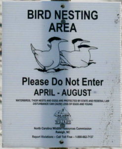
Bird Nesting Area
NC Wildlife Commission has posted signs that say – Bird Nesting Area
The signs are posted on the west end beach strand around 1335 OBW.
People and dogs are supposed to stay out of the area from April through November
. 1) It’s a Plover nesting area
. 2) Allows migrating birds a place to land and rest without being disturbed

A Second Helping
.
Program to collect food Saturday mornings (8:00am to 10:30am) during the summer at the Beach Mart on the Causeway.
1) Twenty-first year of the program
2) Food collections have now exceeded 307,000 pounds
3) Collections will begin on Memorial Day weekend
4) Food is distributed to the needy in Brunswick County
For more information » click here
.
Hunger exists everywhere in this country; join them in the fight to help end hunger in Brunswick County. Cash donations are gratefully accepted. One hundred percent (100%) of these cash donations are used to buy more food. You can be assured that the money will be very well spent.
Mail Donations to:
A Second Helping
% Sharon United Methodist Church
2030 Holden Beach Road
Supply, NC 28462
 News from Town of Holden Beach
The town sends out emails of events, news, agendas, notifications, and emergency information. If you would like to be added to their mailing list, please go to their web site to complete your subscription to the Holden Beach E-Newsletter.
For more information » click here
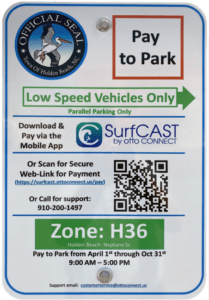 Paid Parking
Paid parking in Holden Beach
Paid parking will be enforced from 9:00 a.m. to 5:00 p.m. daily with free parking before and after that time. All parking will use license plates for verification.
Rates
Parking rates for a single vehicle in all designated areas will be:
$5 per hour for up to four hours
$20 per day for any duration greater than four hours
$80 per week for seven consecutive days
Handicap Parking
A vehicle displaying a handicap license plate and/or hang tag parked in a designated handicap space is free. Any other parking space will require a parking permit via the app.
Annual Passes
Annual permits for the calendar year allow vehicles (this includes low-speed vehicles and trailers) access to designated parking.
$175 for a single vehicle
Passes can be purchased via the app, website or by telephone.
Where to Park
Per ordinance, there is no parking on the streets or rights-of-way except in designated parking spaces identified by Pay-to-Park signs. Click here to view an interactive map. The table with authorized parking can be viewed below.
Citations will be issued for:
• Parking without an active paid permit in a designated parking area
• Parking within 40 feet of a street intersection
• Parking in a crosswalk, sidewalk, or pedestrian access ways
• Parking blocking a driveway or mailbox
• Parking facing opposing traffic
• Parking in a no parking zone, or within right-of-way
• Parking on any portion of the roadway or travel lane
• Parking a non-LSV vehicle in an authorized LSV location
How Do I Pay to Park
The Town uses the SurfCAST by Otto Connect Mobile Solution. This is a mobile app downloadable for Apple and Android devices. Download the app today. Users will setup their account, enter their license plate details and pay for parking directly on the app. Alternatively, users can scan the QR Code located on the parking signs to access a secure website.
The Otto Connect customer service team will be available to help via phone and email.


Solid Waste Pick-Up Schedule
GFL Environmental change in service, October through May trash pickup will be once a week. Trash collection is on Tuesdays only.
Please note:
. • Trash carts must be at the street by 6:00 a.m. on the pickup day
. • BAG the trash before putting it in the cart
. • Carts will be rolled back to the front of the house
GFL Refuse Collection Policy
GFL has recently notified all Brunswick County residents that they will no longer accept extra bags of refuse outside of the collection cart. This is not a new policy but is stricter enforcement of an existing policy. While in the past GFL drivers would at times make exceptions and take additional bags of refuse, the tremendous growth in housing within Brunswick County makes this practice cost prohibitive and causes drivers to fall behind schedule.
Solid Waste Pickup
An additional trash pickup is scheduled for the Saturday after Easter, April 26th.
Solid Waste Pickup Schedule –
starting the Saturday before Memorial Day (May 25th) twice a week
Recycling –
starting after Memorial Day (June 4th) weekly pick-up
Curbside Recycling – 2025
GFL Environmental is now offering curbside recycling for Town properties that desire to participate in the service. The service cost per cart is $119.35 annually paid in advance to the Town of Holden Beach. The service consists of a ninety-six (96) gallon cart that is emptied every other week during the months of October – May and weekly during the months of June – September.
Curbside Recycling Application » click here
Curbside Recycling Calendar » click here

Trash Can Requirements – Rental Properties
GFL Environmental – trash can requirements
Ordinance 07-13, Section 50.08
Rental properties have specific number of trash cans based on number of bedrooms.
* One extra trash can per every 2 bedrooms
..
§ 50.08 RENTAL HOMES.
(A) Rental homes, as defined in Chapter 157, that are rented as part of the summer rental season, are subject to high numbers of guests, resulting in abnormally large volumes of trash. This type of occupancy use presents a significantly higher impact than homes not used for summer rentals. In interest of public health and sanitation and environmental concerns, all rental home shall have a minimum of one trash can per two bedrooms. Homes with an odd number of bedrooms shall round up (for examples one to two bedrooms – one trash can; three to four bedrooms – two trash cans; five – six bedrooms – three trash cans, and the like).
Building Numbers
Ocean front homes are required to have house numbers visible from the beach strand.
Please call Planning and Inspections Department at 910.842.6080 with any questions.
§157.087 BUILDING NUMBERS.
(A) The correct street number shall be clearly visible from the street on all buildings. Numbers shall be block letters, not script, and of a color clearly in contrast with that of the building and shall be a minimum of six inches in height.
(B) Beach front buildings will also have clearly visible house numbers from the strand side meeting the above criteria on size, contrast, etc. Placement shall be on vertical column supporting deck(s) or deck roof on the primary structure. For buildings with a setback of over 300 feet from the first dune line, a vertical post shall be erected aside the walkway with house numbers affixed. In all cases the numbers must be clearly visible from the strand. Other placements may be acceptable with approval of the Building Inspector.
Upon Further Review –
 When is ‘peak season’ for tourists in the Wilmington area?
Soon, families will pack their vehicles with suitcases, coolers and Shibumi shades and make their way to the Wilmington area to enjoy all that it has to offer: beaches, arts, golf, dining and entertainment. Tourist season begins in the spring and runs through the summer and into early fall. But when does the season officially kick-off? And what are the busiest — and least busy — times for tourism? Here’s what to know.
When exactly is “tourist season?”
According to information from Connie Nelson, communications and public relations director with the Wilmington and Beaches Convention and Visitors Bureau, “peak tourist season” is May through September with the “peak of peak” aligning with North Carolina public school calendars, which has traditionally been June through August. But travelers also visit before and after the peak months. “In recent years, the shoulder season months of April/May and Sept/Oct/Nov have become much stronger, largely due to large sports events, meetings and conventions, and visitors who travel without children,” Nelson said in an email.
When is the busiest week for tourists in the Wilmington area?
Nelson explained that according to room occupancy tax collections, July is historically the busiest month for tourism in New Hanover County. She noted that room occupancy tax is reported by month and is not broken down by week. “However, based on observations and feedback from hoteliers, the busiest week in July is the week of the 4th of July,” Nelson said. The Fourth of July is also the busiest holiday for tourism.
What is the least busy time for tourists in the Wilmington area?
Based on room occupancy tax collections, the slowest months have historically been December and January. “Based on past observations, Christmas Eve and Christmas Day are slow for hotel occupancy,” Nelson said.
Read more » click here
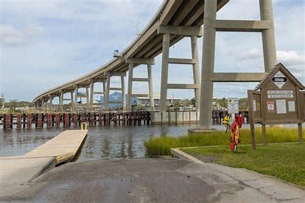
From ramps to paid parking, how boating in Brunswick is ‘in a crisis’
With the popularity of the Brunswick coast, the need for more public boat ramps is on the rise. “We’re in a crisis,” boat captain Cane Faircloth said. Local captains and state representatives are asking for more boat ramps and boat trailer parking in southern Brunswick County.
Existing ramps and parking spaces
The North Carolina Wildlife Resources Commission (NCWRC) builds and maintains boat ramps throughout the state. These ramps can be viewed online using the NCWRC’s interactive maps. The boating access area map marks six public boat ramps in Brunswick County that connect people to the Intracoastal Waterway. The six NCWRC-maintained ramps are located at Sunset Beach, Ocean Isle Beach, Bricklanding Road in Shallotte, Holden Beach, Sunset Harbor and Oak Island. With five out of the six ramps having over 22 boat trailer parking spaces, a total of 233 boat trailer designated parking spaces are at the NCWRC boat ramps. The Oak Island ramp has around 80 boat trailer parking spaces while Holden Beach only has around 15. There are other Intracoastal Waterway boat ramps in Brunswick County that are not maintained by the state. Some additional public boat ramps are the Southport Marina Ramp, Dutchman Creek Boat Launch, NE 55th Street Municipal Boat Ramp in Oak Island, Brunswick River Park in Leland and the Varnamtown Public Boat Ramp.
A need for more
Coastal North Carolina and Brunswick County are seeing rapid growth, Faircloth said. The growth is causing a shortfall in local coastal infrastructure that goes beyond roads and sewer. “It’s a Southeastern North Carolina issue,” Faircloth said. Some neighborhoods along the Intracoastal Waterway have private boat ramps and some boat owners store their boats at a privately owned marina, where the marina transports the boat to and from water for the customer. However, Faircloth said many local boat owners cannot afford marina prices and rely on public boat ramps as their way to the water. “This is the area with the biggest need,” Faircloth said. NCWRC Commissioner Steve Windham said the six boat ramps operate at over 150% capacity. “We need a whole lot more boat ramps,” Windham said, noting the need has only increased in recent years as the number of boat registrations and fishing licenses in the state grows. The lack of boat ramps and parking for vehicles with trailers around Holden Beach are infrastructure shortfalls, Faircloth said. Parking at boat ramps in Brunswick County is “crowded,” Windham said. There are 15 parking spaces at the Holden Beach Boat Ramp and people are fighting for a place to park on a regular work day. Some boaters are being forced to awkwardly park their trailer upwards on a hill. Captain Ryan Williams runs Catch 22 Charters. Williams and Faircloth are regular users of the Holden Beach Boat Ramp for recreational and business uses. Both captains said challenges that come with using the Holden Beach Boat Ramp impact their work life. Local captains have to get to the boat ramp before sunrise so they can avoid wait times and have a parking spot for both their vehicle and boat trailer, Faircloth said. Like Faircloth, Williams said his biggest fight is getting access to the ocean. “I’ve waited over an hour before,” said Williams, noting other charter boat captains use the boat ramps to make a living too. Paid parking programs have also caused hardships for boaters, Faircloth said. Paid parking programs at Brunswick beach towns have forced many people to pay double when all boat trailer parking spaces are full due to their vehicle and boat trailer taking up two parking spaces, he explained. “Most of your working class people can’t afford to pay $40 to go take their Jon Boat out and their two small kids to go fish in the waterway. … It’s just not feasible,” Faircloth said.
Opportunities ahead with state support
Holden Beach commissioners have different ideas for Block Q, a chunk of property located near the boat ramp. As previously proposed, Block Q could have been a new, paved boat trailer parking lot. However, plans have changed, and the paved boat trailer parking design has been scratched. Williams hopes to see the demand for boat ramp parking met soon as more residents and visitors flood the boat ramp at Holden Beach. “We’re so far behind. … It really puts a strain on the fact that we have far outgrown the 15 spots 30 years ago,” Williams said. There are few available properties around Holden Beach that could be used for an additional public boat ramp and boat trailer parking but the NCWRC is working on building a new one, the captains said. “Right now, we are in the process of trying to secure funding for a boat ramp in Holden Beach,” Windham said. The NCWRC’s goal is to purchase a four-acre property and build a boat ramp and kayak/canoe launch near Holden Beach, Windham said. The whole project, including purchasing the property, is expected to cost around $8 million, he said. Local and state officials have seen the need and shown support for a new ramp in the Holden Beach area, Windham added. If people want to show their support, Windham encourages people reach out to local legislatures and Brunswick County commissioners.
Read more » click here
Corrections & Amplifications –
 Brunswick County has grown nearly 50% since 2015, state data show
The North Carolina Budget and Tax Center has released its 2025 Economic Snapshot for Brunswick County, which is now estimated to have a population of 175,000 residents — a 48% increase over the past decade. The state Budget and Tax Center (BTC) Economic Snapshots are released annually and “provide key economic and social indicators from publicly available sources for all 100 counties in North Carolina, along with a comparison to state-level data, with measures for employment, poverty and income, affordable housing, health, education and more.” Much of the data used in the Snapshots come from the U.S. Census Bureau’s American Community Survey (ACS) and the data in the 2025 Economic Snapshot for Brunswick County covers 2019 through 2023. The snapshot indicates Brunswick County’s population has ballooned by nearly 50% since 2015. For comparison, North Carolina’s population has increased by 11% over that timeframe. Based on BTC data, the county has gained over 15,000 residents since the most recent U.S. Census estimate in 2023. Carolina Demography found that Brunswick County has seen the largest population increase in North Carolina from July 1, 2022, to July 1, 2023, growing by 4.6% over that time with a net migration, which is total move-ins subtracted by total move-outs, of 7,821. However, Brunswick County’s natural increase — the number of births subtracted by the number of deaths — from 2022 was -794. Nearby Pender County was the second fastest growing county over that timespan at 4.3%, but its net migration, 2,885, is significantly lower, according to Carolina Demography. Only Mecklenburg and Wake counties had a higher net migration than Brunswick County from 2022 to 2023, though the% change was smaller, at 1.7% for both counties. Of the 175,000 Brunswick County residents, 55,300 residents are employed and 2,400 are unemployed but actively seeking employment, creating an unemployment rate of 4.2%, the snapshot notes. The county’s working population is roughly 57,700 — just 32% of the overall population. The snapshot found fair market rent in Brunswick County in 2025 is $1,280 for a two-bedroom home, slightly more than the U.S. Census’ median gross rent of $1,267 from 2019 to 2023. The Living Income Standard — a measure of what a family consisting of one adult and two children needs in order to cover basic expenses — for Brunswick County is $78,400, compared to $87,700 for the state, the BTC found. From 2019 to 2023, the median Brunswick County worker’s yearly income was $43,800 and the median household income was $74,000. The median worker income in Brunswick County is lower than in neighboring New Hanover ($48,500) and Pender ($46,800) counties but is higher than in western neighbor Columbus County ($38,100). The median household income in Brunswick County ($74,000), however, is higher than in New Hanover County ($72,900) and Columbus County ($48,200) but lower than in Pender County ($76,800). 51% of Brunswick County renters cannot afford rent, according to the snapshot, as that percentage pay more than 30% of their incomes in rent, while 27% of renters pay more than 50% of their incomes in rent. The percentage of Brunswick County renters who pay more than 30% of their income in rent increased 2% from 49% from 2018 to 2022, but the percentage who pay more than 50% decreased slightly from 28% from 2018 to 2022. 9% of Brunswick County residents live in poverty, snapshot data show, and 13% of children live in poverty — down 1% from its rate of 14% from 2018 to 2022. Brunswick County’s high school graduation rate in 2024 was slightly lower than the overall state rate, with the county’s sitting at 85% and the state’s at 87%. Black county residents have the highest graduation rate at 90% followed by Latine residents at 87% then white residents at 85%. The NC Budget and Tax Center Economic Snapshots, including for Brunswick County, can be found here:
https://ncbudget.org/2025-economic-county-snapshots-for-north-carolina/.
Read more » click here
 North Carolina breaks records as tourism spending exceeds 2023 numbers
Tourism spending in North Carolina exceeded 2023 numbers, according to NC officials. In a press release, the Office of the Governor says in 2024, tourists spent “more than $36.7 billion on trips to and within the state.” The previous record was $35.6 billion, which was set in 2023. “Today’s news underscores what we all know: North Carolina is a fantastic place to visit,” said Governor Josh Stein. “As our mountain economies worked to recover from Helene, our Piedmont and coastal destinations remained popular and contributed to the growth of North Carolina’s tourism economy. We must continue to support tourism and small businesses in western North Carolina to help them come back stronger.” According to the economic impacts study commissioned by Visit North Carolina, the state tourism workforce increased 1.4% to 230,338 jobs in 2024. The study also found the payroll increased 2.6% to $9.5 billion. “As a result of visitor spending, state and local governments saw rebounds in tax revenues to nearly $2.7 billion,” Officials explained in a release. Additionally, North Carolina was found to rank No. 5 behind California, Florida, Texas, and New York in domestic visitation. “North Carolinians in all 100 counties benefit from the money that visitors spend,” said Commerce Secretary Lee Lilley. “From our smallest towns to our largest cities, tourism means jobs for more than 50,000 small businesses and our first-in-talent workforce. These workers address travelers’ needs for transportation as well as lodging, dining, shopping, and recreation.” Officials say that as a result of an uptick in travelers, North Carolina residents saved $593 on average in state and local taxes.
Read more » click here
Odds & Ends –

What will summer be like in Wilmington?
Here’s what the Old Farmer’s Almanac predicts
Spring in the Wilmington area can be so unpredictable. One day its beautiful and warm, the next day it’s cold and rainy. Temperatures fluctuate all the time. Lately it has been warmer than usual, and summer hasn’t even started. With the weather being hot and humid already, what will temperatures reach doing the summer? Here’s what to know about The Old Farmer’s Almanac’s summer weather predictions.
When does summer start?
The first day of summer arrives with the solstice on Friday, June 20 and occurs at the moment Earth’s tilt toward the sun is at a maximum.
What does the Old Farmer’s Almanac predict for summer in the Wilmington area?
The Old Farmer’s Almanac predicts that summer will be warmer than normal, temperatures will generally be about average with the warmest periods occurring especially in July and August. While rainfall is expected to be below normal, watch for a tropical storm in mid-July.
What is The Old Farmer’s Almanac?
The Old Farmer’s Almanac has been around for more than 225 years. It is an almanac containing weather forecasts, planting charts, astronomical data, recipes, and articles. An almanac is an annual calendar containing important dates and statistical information such as astronomical data and tide tables.
How accurate is The Old Farmer’s Almanac?The Old Farmer’s Almanac claims an 80% accuracy rate on its predictions.
National Weather Service Wilmington, NC
The National Weather Service Climate Prediction Center is forecasting increased chances for above-normal temperatures this summer across most of the country including Wilmington. Average highs for the three months of summer, June, July and August are 87, 90, and 88 degrees, respectively, and with this forecast it’ll likely exceed those values this summer, according to Tim Armstrong, Meteorologist and Climate Program Leader.
Read more » click here
This and That –
 What should you do when emergency vehicles approach?
Have you ever heard the sirens of an ambulance or firetruck behind you while driving and felt unsure of what to do? Knowing how to respond in these moments can help save lives. Properly yielding allows first responders to reach their destination quickly and safely. Here’s what you need to know next time you find yourself in this situation, according to the North Carolina Department of Public Safety.
How should you respond when an emergency vehicle is approaching?
If an emergency vehicle approaches from behind
On a two-lane road, when an emergency vehicle is approaching from behind, pull over to the edge of the road and come to a complete stop. Keep your foot on the brake to let the emergency vehicle know that your vehicle is stationary. Once the emergency vehicle has passed, you may safely return to the road.
Always maintain a distance of at least 500 feet behind emergency vehicles and never follow them to navigate through traffic or bypass red lights.
If you’re stopped at an intersection and an emergency vehicle approaches from behind, remain where you are unless you are able to pull to the right. Similarly, on a four-lane highway without barriers, both sides of traffic should pull to the right when an emergency vehicle is approaching.
If an emergency vehicle approaches from the opposite direction
The N.C. Department of Public Safety advises drivers to pay attention to the situation around them when an emergency vehicle is approaching from the opposite direction. Caution and yield should be used as needed.
What about emergency vehicles stopped on the side of the road?
North Carolina has had a Mover Over Law since 2002, requiring motorists, if they can safely do so, to move one lane away from emergency vehicles with flashing lights stopped on the side of the road. Otherwise, motorists are expected to slow down and proceed with caution.
Violation of the law can result in a $250 fine, according to the N.C. Department of Public Safety.
What do the color of emergency lights mean?
The N.C. Department of Public Safety defines the following emergency light colors and their uses:
- Red lights: the fire department or an ambulance is responding to a call.
- Blue lights: police.
- Amber or yellow lights: a vehicle engaged in roadside service, including tow trucks, utility vehicles and snowplows.
- Green lights: an ambulance volunteer member is responding to a call.
Read more » click here
Turtle Watch Program –

Turtle Watch Program – 2025
Members of the patrol started riding the beach every morning on May 1 and will do so through October looking for signs of turtle nests.
For more information » click here.
..
.
Turtle Talks
The Holden Beach Turtle Watch Program conducts weekly educational programs on selected Wednesday evenings in June, July and August. Please check our Events Calendar for details on dates, times and locations. Seating is limited.
Children’s Turtle Time
Special programs for younger turtle enthusiasts are held at 4 p.m. on Wednesday afternoons in June, July and August on select dates.
Both programs are free of charge and will be held at the Holden Beach Chapel.
![]()
Holden Beach Turtle Patrol readies for summer programming
Volunteers with the Holden Beach Turtle Watch Program are getting ready to offer weekly educational sea turtle programs this summer. Often called the “Turtle Patrol,” the program was founded in 1989 to monitor and protect the sea turtle population on Holden Beach, a seaside town in Brunswick County. This all volunteer, nonprofit conservation organization operates under the authority of the North Carolina Wildlife Resources Commission. The family-oriented Turtle Talks are scheduled to begin at 7 p.m. June 18 and be held each Wednesday until Aug. 13. A volunteer will speak, a slideshow and film will be shown, and the night will close out with a time to ask questions. The evening program “focuses on the life cycle of the sea turtle and how the Turtle Patrol aids in the preservation of sea turtles, a volunteer will speak about nesting sea turtles, what to look for when visiting the beach, and current nest information,” organizers explained in a release. The first Children’s Turtle Time for the summer is scheduled for 4 p.m. Wednesday, June 25, and is to take place every Wednesday through Aug. 6. “The program introduces young children to the world of sea turtles through hands-on play, games, books and puzzles,” organizers said. This program is designed for two age groups, 3-4 and 5-6. An adult should remain with their child during the 45-minute program. If a family has two or more children that fall within both age groups, organizers advise that two adults attend. Volunteers are available to speak to clubs, classrooms and organizations to promote awareness during the educational outreach program “Turtle Talk on the Road.” Contact the outreach program coordinator by email at [email protected] for more information or to schedule a program. Sea turtles nest on Holden Beach from mid-May through August, and their nests hatch July through October. When the 2025 turtle season began May 1, Turtle Patrol members started patrolling the island each morning looking for signs of a nesting sea turtle crawl on the beach. For details about these educational programs, number of nests, and recent news, https://www.hbturtlewatch.org/.
Read more » click here
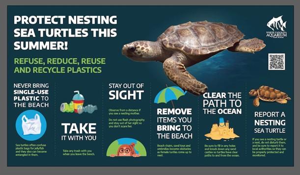
Fort Fisher Aquarium offers tips to protect sea turtles during nesting season
The North Carolina Aquarium at Fort Fisher (NCAFF) has provided the community with tips on how to protect sea turtles during their nesting season beginning this month. “The Aquarium team is passionate about sea turtle conservation and we hope that our work in protecting these species inspires the community to find their own way to protect them,” said NCAFF education curator, Karissa Bearer.
NCAFF suggests a variety of tips, including:
- Reduce, reuse, and recycle plastics.
- Never release balloons. Pop them and put them in the trash.
- Never release sky lanterns. Try alternatives like bubbles or planting trees in celebration.
- Pick up trash and share that data with scientists studying marine plastics.
- Organize or participate in a beach cleanup or local trash pickup.
- Write a letter to the editor or local government officials about the dangers of marine debris.
Read more » click here
Fauna & Flora –

NC State Native Plant Resources » click here
NC Sea Grant Coastal Landscapes » click here
New Hanover County Arboretum Native Plant Garden » click here
Audubon Native Plant Database » click here
Fauna & Flora » click here
Holden Beach recommended plant list – deer resistant & salt tolerant
Factoid That May Interest Only Me –
 Amidst FEMA staff cuts, worries grow about summer hurricane, tornado seasons
The Trump administration wants to rethink FEMA’s role in disasters. So far it’s mostly ’caused a lot of confusion.’
Federal Emergency Management Agency employees are trained to respond to disasters but have struggled this spring with the situation unfolding at their agency. While they’ve been deployed to wildfires in Los Angeles, flooding along the Kentucky River and throughout the southeast in response to Hurricane Helene, FEMA workers have watched a roiling turmoil of staff cuts, slashed budgets and threats to dismantle their agency. They’re fielding difficult questions from friends, co-workers and disaster victims about what the future holds. “It’s caused a lot of confusion,” said Michael Coen, a FEMA veteran of more than 15 years who left his position as chief of staff on Inauguration Day. At least 2,000 of the agency’s roughly 6,100 full-time employees have either left or plan to leave under the waves of terminations and voluntary retirements ordered by Elon Musk’s Department of Governmental Efficiency, Coen told USA TODAY. That doesn’t include a reduction in force expected to take place in the federal government in the coming weeks. President Donald Trump also has launched an agency review and cut funds for some FEMA grant programs, outraging officials in states where those funds already had been committed. The controversy taps into a long-running debate over the role of states and the federal government in disaster response. It’s hard to find a public official who doesn’t think the way the nation responds to disasters could be improved, but the 30% cut in its full-time staff raises concerns about whether FEMA will be able to respond to major disasters during the approaching summer storm season that could bring hurricanes, tornadoes and wildfires. Jay Inslee, whose term as the Democratic governor of Washington State ended in January, is among those gravely concerned about FEMA’s ability to respond. “Gutting FEMA is just going to make more and more families have to be living under blue tarps for years, and not to have the financial assistance they deserve when they pay their taxes,” Inslee said. “I’m outraged on their behalf.”
States can’t go it alone, workers are worn out
Major disasters require federal resources, and state and local governments cannot cope on their own, said Shana Udvardy, senior climate resilience policy analyst at the Union of Concerned Scientists “With the summer danger season of extreme weather, including climate-fueled disasters, getting underway soon, these attacks on FEMA could not come at a worse time,” Udvardy said. “Congress must push back assertively on these egregious plans in a bipartisan way ‒ disasters do not discriminate based on politics.” When enormous natural disasters befall communities, especially small ones, they just don’t have the local resources, Inslee said. “It’s basically everybody pitching in together from the county to the Red Cross to the state, to the federal government.” FEMA’s remaining full-time employees, even those who work at headquarters and don’t typically deploy, have been warned to be ready to deploy to disasters this summer. The agency has been short-staffed for years, federal documents show. The staff flexes up and down as the need arises, with roughly 12,000 employees who respond as reservists or local temporary hires. Among the cuts this year to the permanent employees were 200 probationary staff, dismissed because they had been either recently hired or recently promoted. Coen said another 800 took the “fork-in-the-road” plan that placed employees on administrative leave with pay until the end of the summer, when they’d lose their jobs. “A lot of people with the agency were just exhausted,” he said. “Last year was a very challenging year for FEMA employees with all the disasters that took place, plus all the (Hurricane) Helene misinformation.” In the aftermath of Helene, some FEMA officials found their personal information had been made public on the web, and some were threatened. The inauguration opened a new chapter. Trump had been critical of FEMA during the campaign, and his first official trip was to visit the Helene disaster zone in western North Carolina, where he said the administration was “very disappointed” in FEMA. After information was leaked from one early meeting with the new FEMA officials, at least a dozen staff members were asked to submit to lie detector tests, Coen said. Employees are afraid to talk, even to former colleagues, because they’re afraid they might be subjected to a lie detector, Coen said. “If the head of the agency isn’t even respected by the Secretary’s office, if he’s being subjected to a lie detector test, you know, why would I stay here?” Even some of the younger staff are thinking, “I don’t need this anxiety,” he said.
FEMA’s role in disaster response
FEMA responds to every major natural disaster, assessing damage and providing assistance under pre-established guidelines and state agreements. In Washington State, “FEMA has been a tremendous, absolutely essential partner,” Inslee said. “From a boots-on-the-ground perspective, FEMA has been incredibly valuable.” In recent years, FEMA has seen an enormous increase in the number of disasters that require a response. That’s, in part, because the number of extreme weather events is rising, with more intense rainfall and larger wildfires brought on by climate change, Inslee said. That’s backed up by numerous federal reports. The scope and complexity of disasters are also growing because more people live in vulnerable areas, where they’re more exposed to storms and fires. In the current fiscal year, the agency carries financial obligations for 30 major disasters, dating back to Hurricane Katrina in 2005, according to its February 2025 monthly report. Its actual and estimated total obligations for those disasters are around $57 billion. Its budget authority for this year was $33 million.
FEMA’s reputation problems
The agency’s reputation has struggled in part because FEMA meets people when they are likely to be at their lowest, most desperate point, and, in part, because its mission is often misunderstood, Coen said. FEMA is supposed to function primarily as a backstop for people who don’t have insurance. It covers uninsured losses, so if you have homeowners insurance, “you’re probably not going to be eligible,” he said. “That frustrates people who feel like they did everything right.” Victims often expect FEMA to be there first, even though the agency must wait to be requested by state government. That message is often hammered home by emergency management officials, who remind residents to store enough supplies for five to seven days after a disaster. The agency’s mission has evolved and it walks a tightrope at times between trying to battle fraud and not attach so many rules that money can’t get where it needs to. State and local officials often refer to the recovery phase as the “disaster after the disaster.” A General Accounting Office Report in 2022 made numerous suggestions for addressing “red tape” in disaster recovery. Coen said a prime example of the misunderstandings is the frustration from states where the Trump administration recently denied claims for disaster assistance and denied extensions of certain assistance in others. “I’m personally not critical of that,” he said. When the federal government takes the bulk of the financial responsibility, it often slows down recovery, he said, adding that when new bridges or other infrastructures are complete, other officials and organizations sometimes take credit and forget to acknowledge FEMA’s role.
What happens next with FEMA?
By executive order on Jan. 24, Trump ordered a “full-scale review” of FEMA. Federal responses to Helene and other disasters “demonstrate the need to drastically improve” the agency’s efficiency, priorities and competence, his executive order stated. Appointees to the review council, announced April 28, will be tasked with taking a sweeping look at everything from disaster aid during periods before and after FEMA, the traditional role of states and citizens in securing life, liberty and property and how FEMA could serve as a support agency if the states were in control of disaster relief. They’re expected to make recommendations to Trump for improvements or structural changes to promote the national interest and enable national resilience. Members include Secretary of Defense Pete Hegseth, Homeland Security Kristi Noem, Texas Gov. Greg Abbott, Florida’s emergency management chief Kevin Guthrie and Tampa, Florida, Mayor Jane Castor. Noem already has stated she wants to eliminate FEMA. On Truth Social, Trump posted: “I know that the new Members will work hard to fix a terribly broken System and return power to State Emergency Managers.” Udvardy, with the Union of Concerned Scientists, is among many who agree there’s room for reform at the federal agency. Genuine reforms, she said, “should be informed by science, expertise, and the experiences of disaster survivors.” Meanwhile, the clock is ticking. The start of the Atlantic hurricane season is just a month away.
Read more » click here
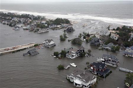 America is becoming less ready for natural disasters
The president is destroying programs that help communities prepare for climate effects.
President Donald Trump’s administration is on a crusade against efforts to grapple with climate change. From the start of Trump’s second term, officials have halted clean energy projects or attempted to claw back funding for them, and, at the same time, they have fast-tracked permitting for fossil fuels. The administration has also been tearing down federal programs that protect Americans against the kind of extreme weather that climate change brings, making it harder for communities to prepare for and recover from natural disasters. These decisions will weaken the economy and — more importantly, could cost lives. Start with the administration’s gutting of the National Oceanic and Atmospheric Administration. The agency, which is part of the Commerce Department, monitors weather, conducts climate research and maintains intricate forecast models that are essential to much of the economy. Farmers use the models to decide which crops to plant and when, and the shipping and aviation industries use them to steer around hazardous weather. Nevertheless, many people in the administration see the agency as a source of “climate alarmism,” as Russell Vought, who is now director of the Office of Management and Budget, put it in a proposal for Project 2025. Commerce officials slashed hundreds of employees from NOAA’s workforce. The administration’s budget framework released this month also proposed cutting $1.3 billion from the agency by targeting “climate-dominated research, data, and grant programs, which are not aligned with Administration policy-ending ‘Green New Deal’ initiatives.” A NOAA spokesperson said it is “actively enhancing disaster readiness and lifesaving capabilities” through “transformation and strategic investments in advanced technology.” But the layoffs alone will make it difficult to maintain the agency’s vast network of weather radars. Thirty of the National Weather Service’s 122 local forecast offices now operate without a chief meteorologist, CNN has reported. As extreme weather events become more common — and more expensive — this could prove disastrous. Then there’s the Federal Emergency Management Agency, which the president and many of his advisers repeatedly have threatened to eliminate. In 2023, the Government Accountability Office determined that understaffing at FEMA was impeding disaster responses. Yet Trump’s Department of Homeland Security has reduced its workforce by 20 percent through layoffs and voluntary buyouts. Trump this week also fired the acting head of the agency a day after the administrator told Congress that he didn’t believe FEMA should be eliminated. Meanwhile, the administration has repeatedly denied federal aid to disaster-stricken regions, arguing that states should lead response efforts. This earned a rebuke from Republicans in Arkansas, who pushed the administration to reconsider its denial of funding after deadly storms in March. “Given the cumulative impact and sheer magnitude of destruction from these severe weather events, federal assistance is vital to ensure that state and local communities have the capabilities needed to rebuild,” a group of Republican lawmakers from the state wrote in a letter to Trump. The administration’s aversion to FEMA stems partly from misinformation, amplified by the president. He has claimed that the agency intentionally withheld aid to Republican residents in North Carolina after Hurricane Helene last year. This falsehood has undermined the agency’s difficult work and led to threats against relief workers. Last month, the administration also announced it would end FEMA’s Building Resilient Infrastructure and Communities program, which was created during the first Trump administration and expanded under President Joe Biden to help communities harden themselves against disasters, such as by raising roads prone to flooding. The White House has also been scaling back FEMA’s Hazard Mitigation Assistance program, which awards post-disaster grants to help communities rebuild in ways that make them more resilient. Also in April, the administration dismissed all the scientists working on the next National Climate Assessment. The congressionally mandated report, which is due to be released by 2028, is meant to synthesize the latest climate research to help state and local governments respond to climate change. Contributors to the report said it would place a new emphasis on adaptation strategies. Each of these decisions has been reckless. Taken together, they reveal a basic disregard for the scientific programs and government infrastructure that have kept Americans safe for decades. The president almost seems to be daring Mother Nature to strike while the country’s defenses are down. Lawmakers — especially Republicans, who are no doubt nervous about their party’s political future — need to speak up for their constituents and press for climate mitigation programs to continue. So should business leaders who rely on government data to protect their investments. Americans need a government that cares about their safety.
Read more » click here
Beach Strand –
 As weather warms, nesting shorebirds and sea turtles join people heading to NC’s beaches
With people flocking to the coast, officials hope education and outreach can help efforts to share the sand with nesting birds and sea turtles.
As the weather warms, sun-seeking tourists aren’t the only ones drawn to North Carolina’s rich necklace of barrier islands along its 320 miles of coastline. If you’re visiting the beach this summer, there’s a good chance you’ll see wildlife mixed in with visitors and the occasional resident. But sharing valuable beach real estate with nesting shorebirds and sea turtles can be challenging. Mix in the loss of habitat on many islands to development, the growing risk from climate change, and the increased threat of disturbance tied to human activities, dogs and even predators and the odds are often stacked against the native fauna. The eggs and chicks of nesting shorebirds often blend in perfectly with the sand, making it easy for people or pets to accidentally step on them. Getting close to the nests or babies can be just as bad, scaring the parents off and leaving the eggs and chicks at the mercy of predators and the summer heat. That’s where groups like the N.C. Wildlife Resources Commission and Audubon North Carolina come in to help level the playing field. Hundreds of signs ring the state’s coastal nesting sanctuaries from Currituck Sound in the north to Sunset Beach in the south, warning visitors to respect nesting areas. In some locations, including Wrightsville Beach, volunteers help reinforce that message. Hope Sutton, eastern wildlife diversity supervisor with the wildlife commission, said education and outreach efforts are some of the most powerful tools officials have to raise awareness about the birds’ requirements. “It’s a critical component, whether its students at Wrightsville Beach Elementary making cute signs to warn beachgoers to stay out of the refuge or adults learning about these birds through one of our outreach activities,” she said. “Our behavior patterns can really impact the chance of success many of these birds species have.” The helping hand comes as regulators worry about the future of some of the state’s shorebirds. North Carolina’s 2023 waterbird survey, which is conducted every three years and is a collaborative effort among government agencies and environmental groups, showed substantial dips in the numbers of many nesting shorebirds. Among wading birds, that list included cattle egrets, tricolored heron, little blue herons, snowy egrets and glossy ibis. Beach-nesting species showing substantial declines included the common tern, gull-billed tern, and Caspian tern. Another species that is in trouble is the black skimmer, with North Carolina’s population decreasing by half since 1999. Because skimmers nest directly on the open sand, they are especially vulnerable to disturbance and loss of nesting sites. But the survey wasn’t all bad news. Least tern numbers were found to be increasing, with many of the nests found on the beaches at the south end of Wrightsville Beach and on Lea-Hutaff Island in Pender County. Brown pelicans also are doing well, with 5,227 nests reported in 2023, well above the 15-year average of about 4,000 nests. Many of the shorebirds holding their own nest on spoil islands, like those in the Cape Fear River or Intracoastal Waterway, or on sections of protected natural areas like Masonboro Island that are hard to access. But climate change is an unknown variable that could add to the pressure many species face. On low-lying manmade dredge islands, for example, rising seas and stronger tropical storms tied to warming temperatures could increase erosion and over wash threats. “And the competition for sand is already tough and is likely to get worse in the coming decades,” Sutton said, referring to the limited nearshore sand resources and many coastal towns now seeking nourishment projects to boost their eroding beaches. A warming climate also could prompt some birds to nest sooner. Lindsay Addison, a coastal biologist with Audubon North Carolina, said learning to share the beach and knowing when to back away, such as when a shorebird starts acting irritated, can go a long way to help. “Anyone who has lived down here for a while knows that there are more and more people now, and sometimes it’s really hard to go anywhere along the coast and not run into a lot of people,” she said. “The birds also are experiencing that, and there are a lot of opportunities for people to disturb them and impact their survival. “But if we just keep our distance and take some other steps, like keeping our dogs on a leash during certain times, it can make a really huge difference.” Shorebird nesting season runs from March through mid-September.
Turtle time
Shorebirds aren’t the only ones looking to nest on area beaches. Peak sea turtle nesting season begins May 1 and continues through the end of October. Most local beaches are monitored daily during sea turtle nesting season to look for evidence of nests, which are then monitored and protected if needed during the roughly two-month incubation period. While sea turtle nesting numbers have been showing increases in recent years, regulators and environmentalists warn the marine reptiles still face many threats − especially during the decades they navigate the oceans before females return to their birth beach to nest. While on the beach, threats dangers include holes dug in the sand and left by beachgoers, which can trap hatchlings after they emerge from the nest, and bright lights from homes and businesses that can distract nesting mothers and hatchlings and lead them away from the ocean.
Sharing the beach
Tips from the N.C. Wildlife Resources Commission on how to share the beach with nesting wildlife this summer:
- Respect the boundaries of the roped-off nesting areas
- Keep dogs on a leash
- Follow beach driving regulations
- Throw away trash properly, including fishing line and kite strings
- Don’t feed sea gulls or least terns
- Don’t fly drones or kites near nesting sites
Read more » click here
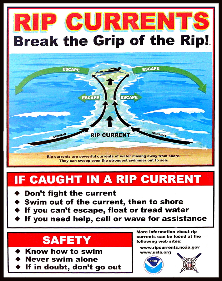
Most rip current deaths are preventable. Yet people keep drowning.
Beach-safety experts are frustrated by the mounting fatalities despite awareness campaigns and improved forecasts
Rip-current deaths in the United States are running ahead of last year’s pace — at least 29 since the beginning of the year — with peak beach season yet to come. Experts are warning the public to be aware of this largely hidden hazard ahead of Memorial Day weekend, traditionally one of the busiest beach weekends of the year. The risk of dangerous rip currents is expected to be particularly high this weekend along portions of the Southeast coast where a storm could produce heavy rain, gusty winds and rough seas. Experts say most rip-current fatalities can be prevented. Still, the number of annual rip-current deaths has steadily climbed since the National Weather Service began tracking them in 2010, reaching a record of 130 in 2021, then dipping to 85 last year. Rip currents were the third-leading cause of weather-related deaths from 2012 to 2021, behind only heat and flooding, according to the Weather Service, and in a typical year they kill more people than lightning, hurricanes or tornadoes. Rip currents are strong, narrow streams of water that flow away from the shoreline and can suddenly sweep swimmers out to sea. They can form on almost any beach with breaking waves, especially near low spots or breaks in sandbars, and near jetties or piers. Predicting where and when a rip current will form is difficult because of the many weather and ocean factors involved. The Weather Service cautions that “rip currents often form on calm, sunny days.” The Weather Service lists 26 rip-current deaths this year through April 27, not including three deaths believed to be caused by rip currents on April 28 in Destin, Fla., May 6 in Ocean City, Md., and May 12 at Cannon Beach, Ore. At this point last year, there were 19 total such deaths. Beach-safety experts are expressing frustration as fatalities trend higher again this year despite annual awareness campaigns, such as the United States Lifesaving Association’s National Beach Safety Week held every year during the week before Memorial Day, and recent improvements to rip current forecasts. “It is frustrating when we produce videos and graphics and educational information and release it at the beginning of each beach season, and it still misses so many people,” Scott Stripling, a senior meteorologist at the National Hurricane Center in Miami, said in an email. “The problem seems to be one of communication and/or lack of attention by the general public.”
Rip-current forecasts and warning signs
The Weather Service issues daily rip-current forecasts for beaches on the Atlantic Ocean, Gulf Coast, Southern California, Great Lakes, Puerto Rico and the U.S. Virgin Islands. The forecasts categorize the rip-current risk as low, moderate or high, and are informed by a rip-current model recently developed by NOAA that has made it possible to differentiate the risk between adjacent beaches. Previously the same forecast could span 100 miles or more. However, the model doesn’t enable reliable forecasts of the exact location and time of rip currents. These are influenced by a number of factors including wave characteristics, water levels, winds and the shape of a beach. Advances in artificial intelligence could help with rip-current detection — NOAA is partnering with the Southeast Coastal Ocean Observing Regional Association on a project using AI to detect rip currents in webcam imagery — but such efforts are still in their infancy. In some cases, there are visible clues to the existence of a rip current, such as a break in the waves, foamy water or objects being carried offshore, or darker water that is due to a break in a sandbar. Often, though, rip currents are difficult to see, or are best seen from a high point such as a dune line or the top of a beach access. Rip currents are particularly hard to spot in South Florida, where, the Weather Service says, they “consistently rank at or near the top of the list of deadliest weather-related hazards,” because there is not much sediment to darken or muddy the current at the shoreline. In Brevard County alone, home to nearly 72 miles of sandy beaches, there have been eight apparent rip-current drownings since November, all at beaches without lifeguards. “We have clear-water rips, so these offshore-flowing currents are very hard to detect,” Stephen Leatherman, a professor in the department of earth and environment at Florida International University, said in an email. “The best thing is to have lifeguards and for people to swim close to lifeguards. But lifeguards are very expensive, and Florida has 825 miles of good quality sandy beaches which are swimmable for most of the year.”
Warnings and tips for surviving a rip current
Rip currents flow at speeds up to 5 miles per hour. That may not sound fast, but it’s faster than many Olympic swimmers. If you are caught in a rip current, experts say not to swim directly back to shore against the current, which can quickly exhaust and drown you. Instead, swim parallel to the shore until you are out of the current, which is typically no wider than about 50 to 100 feet. You might also escape by floating or treading water, allowing the current to take you out just past the breaking waves where many rip currents tend to dissipate, and then circulate you back toward the shore. However, some rip currents can extend hundreds of yards offshore. If you see someone caught in a rip current, experts urge you not to risk your own life to attempt a swimming rescue unless you have been trained to do so and have a flotation device to assist you and the person in distress. Instead, you should get help from a lifeguard or call 911 if no lifeguard is present. You should also throw the victim something that floats, such as a lifejacket, body board, cooler or a ball, and yell instructions on how to escape. Experts agree that the best way to survive a rip current is to avoid it in the first place. That means checking the rip-current forecast before you enter the water, heeding warnings for rip currents or rough surf, and only swimming close to a lifeguard. The United States Lifesaving Association estimates the chance of someone’s drowning at a beach with a lifeguard at 1 in 18 million. “Lifeguards are trained to spot rip currents and other beach hazards and intervene as and when needed,” Chris Houser, a professor at the University of Windsor School of Environment and a longtime beach-safety researcher, said in an email. “While there is some evidence that individual beach users can be trained to spot rips, most beach users are not aware of what to look for.” U.S. lifeguards make an estimated 80,000 or more rip-current rescues each year, which suggests that education and warning messages are not reaching or are not resonating with as many people as experts would like. “If the lifeguards are flying precautionary flags, and there are signs on the lifeguard stand identifying the potential for rips in that area, and the National Weather Service and media have advertised that there is at least a moderate risk for rip currents to be present at your local beach, what else can we do?” the Weather Service’s Stripling said.
Read more » click here

 Staying safe at the beach: Rip currents, jellyfish, sharks, and other hazards
A trip to the beach can turn deadly (or painful) due to natural hazards but being aware of risks and mitigating hazards is a good way to prevent problems.
Picture this: warm weather, blue skies, and your toes in the sand — it sounds like a perfect lazy summer day at the beach. Maybe you decide to cool down in the ocean and find yourself bobbing around when suddenly you realize you are a little too far out. As panic sinks in and you start to swim towards dry land you realize your efforts are in vain and your whole body is getting tired, all the while you are drifting further into the Atlantic — you have gotten stuck in a rip current. It’s not the only potential danger in the ocean, though. There are also sharks. And, of course, there are some things on shore that ruin your day at the beach, too, including stepping on jellyfish and, of course, good old-fashioned sunburn.
Rip currents
According to the U.S. Lifesaving Association (USLA), 80 percent of all ocean rescues are related to rip currents and annually more than 100 fatalities across the country are due to rip currents. While it is obvious that swimming at a beach with lifeguards is one of the safer options, there are plenty of area beaches that lack lifeguards or maybe ocean rescue season has not started just yet. So, what is the best course of action for surviving a rip current? According to the National Weather Service, there are several things swimmers should keep in mind when dealing with these often-unseen dangers.
- Relax. Rip currents don’t pull you under.
- A rip current is a natural treadmill that travels an average speed of 1-2 feet per second but has been measured as fast as 8 feet per second — faster than an Olympic swimmer. Trying to swim against a rip current will only use up your energy; energy you need to survive and escape the rip current.
- Do NOT try to swim directly into to shore. Swim along the shoreline until you escape the current’s pull. When free from the pull of the current, swim at an angle away from the current toward shore.
- If you feel you can’t reach shore, relax, face the shore, and call or wave for help. Remember: If in doubt, don’t go out!
- If at all possible, only swim at beaches with lifeguards.
- If you choose to swim on beaches without a lifeguard, never swim alone. Take a friend and have that person take a cell phone so he or she can call 911 for help.
Sharks
Sharks are a fear on most every swimmer’s mind, regardless of the actual dangers posed by the large predatory fish. “NOAA states that while shark attacks are rare, they are most likely to occur near shore, typically inshore of a sandbar or between sandbars where sharks can be trapped by low tide, and near steep drop-offs where sharks’ prey gather. While the risks are small, it’s important to be aware of how to avoid an attack,” according to previous reporting.
Suggestions from NOAA for reducing the risk of a shark attack include:
- Don’t swim too far from shore.
- Stay in groups – sharks are more likely to attack a solitary individual.
- Avoid being in the water during darkness or twilight when sharks are most active.
- Don’t go in the water if bleeding from a wound – sharks have a very acute sense of smell.
- Leave the shiny jewelry at home – the reflected light resembles fish scales.
- Avoid brightly-colored swimwear – sharks see contrast particularly well.
Sunburns
Most everyone has experienced a sunburn at one point in their life and while not often thought as a major concern for many, overexposure to UV light can cause serious long-term problems including skin cancer. The Centers for Disease Control and Prevention (CDC) recommends using at least S.P.F. 15 sunscreen at least 15 minutes prior to sun exposure. Wearing a hat, long sleeves, and other protective clothing is also recommended to keep skin protected.
Jellyfish
Jellyfish and Portuguese Man of War have been spotted along the beaches of New Hanover County and surrounding area beaches already this season and the little floating creatures can pack a punch. Often times beachgoers will spot them washed up on shore and other times they can be spotted in the water, but it is best to avoid them when you can. “While all jellyfish sting, not all contain poison that hurts humans. Be careful of jellies that wash up on shore, as some can still sting if tentacles are wet. NOAA recommends that if you are stung by a jellyfish to first seek a lifeguard to give first aid. If no lifeguards are present, wash the wound with vinegar or rubbing alcohol,” NOAA suggests. And what about that … other method of treating stings? Turns out, it’s a myth. In fact, urine can actually aggravate the stinging cells of jellyfish, making things worse. These cells, which detach and stick into the skin of prey, can continue to inject venom. Urine, as well as fresh water, can cause an imbalance to the salt solution surrounding the stinging cells, causing them to continue to fire. According to Scientific American, if you don’t have vinegar or rubbing alcohol, rinsing with salt water may be your best bet.
Read more » click here

Storm Events –
 Hurricane Vehicle Decals
Property owners were provided with four (4) decals that were included in this month’s water bill. It is important that you place your decals in your vehicle or in a safe place. A $10 fee will be assessed to anyone who needs to obtain either additional or replacement decals. Decals will not be issued in the 24-hour period before an anticipated order of evacuation.
The decals are your passes to get back onto the island to check your property in the event that an emergency would necessitate restricting access to the island. Decals must be displayed in the driver side lower left-hand corner of the windshield, where they are not obstructed by any other items. Officials must be able to clearly read the decal from outside the vehicle.
Property owners without a valid decal will not be allowed on the island during restricted access. No other method of identification is accepted in an emergency situation. Click here to visit the Town website to find out more information regarding decals and emergency situations.
EVACUATION, CURFEW & DECALS
What is a State of Emergency?
A proclamation by the Town which enacts special ordinances and/or prohibitions during emergency situations to protect the public, public health and property. These prohibitions can include limitations on movement, curfews, directing of evacuations, controlling ingress and egress to the emergency area, alcoholic beverages, and more. State of Emergencies are issued in accordance with N.C.G.S. 166A-19.22.
What is a curfew?
A curfew is an order, typically during a State of Emergency, which requires all persons in the affected areas to remain on their own property. During a curfew, you are not free to move about public domain areas or on others’ property. Violations of a curfew could lead to arrest in certain situations.
What is a voluntary evacuation?
A voluntary evacuation creates a recommendation for all parties in the affected area to get their affairs in order hastily and evacuated.
What is a mandatory evacuation?
A mandatory evacuation means you must leave the area in which an order has been issued. With recent changes to the laws in North Carolina, you no longer have the option of staying in an area under an order of mandatory evacuation.
Why is the sewer system turned off during a storm/event?
Often the sewer system is turned off during storms which have the potential to create significant flooding on the island. The system is turned off to protect its integrity. If it were left on, it could pose a significant threat to the public health. When the system is manually shut down, it also greatly reduces the time needed to bring it back up after an event which equates to getting residents and guests back on the Island much faster.
Why is there a delay for decal holders to get back on the island once a storm ends?
After a storm, many things must occur before even limited access can be allowed. Some of those things include making sure the streets are passable; the sewer system must be restarted to comply with State laws; the utilities (water, sewer, electricity, propane supplies) must be checked to ensure no safety risk are present; and the post-storm damage assessment team needs to perform an initial assessment.
Where can I get up-to-date information during and after a storm or State of Emergency?
You can sign up for the Town email service by clicking here. The newsletter, along with the Town’s website will be the main sources of information during an emergency situation. Links to the Town’s official Facebook and Twitter pages can be found on the website. You can also download our app for Apple and Android phones by accessing the app store on your smart phone and searching Holden Beach.
Please refrain from calling Town Hall and Police Department phone lines with general information questions. These lines need to remain open for emergencies, storm management and post-storm mitigation. All updates concerning re-entry, general access, etc. may be found on the Town’s website and other media outlets.
Why do I see others moving about the island during a curfew?
If a curfew order is in place, you must stay on your own property. You may see many other vehicles moving about the Island. We often receive assistance from other local, state, federal and contract personnel during events. It is likely these are the personnel you are seeing, and they are involved in the mitigation process for the event. Please do not assume that a curfew order has been lifted and/or you are free to move about the island.
Can I check my friends’ property for them?
If a curfew order is in place, you may ONLY travel to your personally owned property. Traveling about the Island to check on others’ property is not allowed. is in place, you may ONLY travel to your personally owned property. Traveling about
Who can obtain decals?
Only property owners and businesses who service the island can obtain a decal.
How do I get decals for my vehicle…?
If I am an owner?
Decals will be mailed out in water bills to property owners before the season starts. Those owners who need additional decals can contact Town Hall. A fee may apply, please check the current fee schedule.
If I am a renter?
You must contact the owner of the property to obtain a decal.
If I am a business owner on the Island?
You must contact Town Hall to obtain a decal.
If I am a business owner off the Island that provides services on the Island?
You must contact Town Hall for eligibility and to obtain a decal.
When does my decal expire?
All decals expire on the last day of the calendar year as indicated on the decal.
Where do I put my decal on my car?
Decals must be displayed in the lower left-hand corner of the windshield, where they are not obstructed by any other items to include window tinting, other decals, etc. Officials must be able to clearly read the decal from outside the vehicle. Please note that re-entry will not be allowed if a current, intact decal is not affixed to the windshield as designated.
How do I replace a decal if I get a new vehicle?
If you trade a vehicle or otherwise need a replacement decal, you may obtain them from Town Hall during normal business hours. A fee may apply, check the current fee schedule.
Can I obtain a decal right before an emergency occurs?
While most of the storms we deal with are tropical in nature with some type of advanced warning, we do experience many other types of events that could create a State of Emergency without warning. All eligible parties should obtain decals as early as possible each year to avoid being denied access to the Island. Decals shall not be issued during the 24-hour period prior to an anticipated order of evacuation so staff can concentrate on properly preparing the Town for the storm/event.
Can I use a tax bill or another document for re-entry?
No. You MUST have a decal to re-enter the Island until it is open to the general public.
How does re-entry after a storm during a State of Emergency work?
The bridge is closed to all vehicle access, except for official vehicles. Once those with proper decals are allowed access, they must conform with the current rules in place by the specific State of Emergency Order. After all hazards have been rendered safe, the bridge will be opened to the general public. A curfew could remain in effect however, to ensure the safety and security of the Island and its residents and guests. Please understand this process typically takes days to evolve and could be significantly longer, depending on the amount of damage sustained. Please refrain from calling for times for re-entry, as those are often not set on schedule. Instead, stay tunes to local media outlets and official social media accounts for accurate updates.
How can I check on my property if access is limited to the Island?
Once it is safe, property owners with valid decals will be allowed back on the Island after a storm/event. At this point, you can travel to your property, in accordance with the rules of the specific State of Emergency Order currently in place.
If you live out of the area, please do not travel to the Island until you are certain you will be allowed access. Stay tuned to those media outlets and email services that are of official nature for this information. Also, be certain you have your current, valid decal properly affixed to your vehicle.
It is a good idea to be sure your contact information is current with the Town tax office as this is the location Town officials will use in the event you need to be contacted.
For more information » click here
NC General Statute 166A-19.22
Power of municipalities and counties to enact ordinances to deal with states of emergency.
Synopsis – The governing body may impose by declaration or enacted ordinance, prohibitions, and restrictions during a state of emergency. This includes the prohibition and restriction of movements of people in public places, including imposing a curfew; directing or compelling the voluntary or mandatory evacuation of all or part of the population, controlling ingress and egress of an emergency area, and providing for the closure of streets, roads, highways, bridges, public vehicular areas. All prohibitions and restrictions imposed by declaration or ordinance shall take effect immediately upon publication of the declaration unless the declaration sets a later time. The prohibitions and restrictions shall expire when they are terminated by the official or entity that imposed them, or when the state of emergency terminates.
Violation – Any person who violates any provisions of an ordinance or a declaration enacted or declared pursuant to this section shall be guilty of a Class 2 misdemeanor.
Hot Button Issues –
Subjects that are important to people and about which they have strong opinions

Climate
For more information » click here.
There’s something happening here
What it is ain’t exactly clear
Hottest decade
The latest “State of the Global Climate” report has been released and the news is pretty dire: our world has just experienced its hottest decade. According to the World Meteorological Organization, 2024 was the hottest since record-keeping began and was likely the first time global temperatures exceeded 1.5 degrees Celsius above the baseline set in 1850-1900. Atmospheric concentrations of carbon dioxide, methane and nitrous oxide were at the highest levels in the last 800,000 years. Such record levels of greenhouse gases — along with the El Niño weather pattern — were mostly to blame for the higher temperatures.
Earth’s 10 Hottest Years Have Been the Last 10
A report from the World Meteorological Organization confirms that 2024 was the hottest year on record and the first year to be more than 1.5 degrees Celsius above the preindustrial era.
With the addition of 2024, yet another record-hot year, the past 10 years have been the 10 hottest in nearly 200 years of record-keeping, the World Meteorological Organization reports. “That’s never happened before,” said Chris Hewitt, the director of the W.M.O.’s climate services division. It marks the first time since record keeping began that all of the 10 hottest years have fallen within the most recent decade. 2024 was the single warmest year on record, surpassing even 2023’s wide lead over other recent years. The planet’s surface was approximately 1.55 degrees Celsius warmer than its average during a reference period that approximates the preindustrial era, from 1850-1900. The annual report from the W.M.O., a United Nations agency, includes input from dozens of experts and institutions from around the world and sheds further light on the record-breaking heat of 2024 and places it in the context of Earth’s long-term warming from climate change. The extra energy in the atmosphere and the oceans helped fuel climate-related disasters around the globe. Extreme weather events like drought, storms and wildfires displaced hundreds of thousands of people from their homes, the report says. Atmospheric levels of greenhouse gases released from fossil fuel combustion continue to rise. In 2024, the concentration of carbon dioxide hit amounts unseen in at least two million years, according to the report. Concentrations of two other important greenhouse gases, methane and nitrous oxide, reached levels unseen in at least 800,000 years. Homo sapiens, or modern humans, emerged around 300,000 years ago, so our species has never before experienced an atmosphere so laden with planet-warming greenhouse gases. When countries signed the Paris Agreement in 2015, they agreed to try to limit global warming to 1.5 degrees Celsius above preindustrial levels. “While a single year above 1.5 degrees C of warming does not indicate that the long-term temperature goals of the Paris Agreement are out of reach, it is a wake-up call that we are increasing the risks to our lives, economies and to the planet,” Celeste Saulo, the secretary general of the W.M.O., said in a statement. The new report estimates that long-term warming has reached 1.25 to 1.41 degrees Celsius above preindustrial levels, although the margins of error for some estimates extend beyond 1.5 degrees. The report authors estimate that last year, El Niño and other factors contributed an additional 0.1 or 0.2 of a degree of temporary warming. El Niño is a natural climate pattern that tends to slightly raise the overall surface temperature of the planet. Record warmth, however, continued into 2025, even through El Niño’s transition into the opposing pattern, La Niña. “It’s been really quite extraordinary to see that warmth continue for so long,” John Kennedy, the scientific coordinator and lead author of the report, said during a call with reporters. This warmth is especially apparent in the oceans, where key indicators of climate change are now accelerating. The oceans have so far absorbed around 90 percent of the additional heat trapped inside Earth’s atmosphere by greenhouse gases. The oceans’ heat content — a way to measure this warmth throughout different depths — also reached a record high last year. Over the past two decades, from 2005 to 2024, the oceans warmed more than twice as fast as they did from 1960 to 2005, according to the report. Increased ocean temperatures have had devastating consequences for marine life. By April 2024, warm-water corals had been bleached in every ocean basin where they grow. Global average sea-level rise also reached a record high in 2024, according to the report. The speed at which the seas are rising has also more than doubled in recent years: 4.7 millimeters per year in the past decade, from 2015 to 2024, compared with 2.1 millimeters per year from 1993 to 2002. The World Meteorological Organization’s work depends on international cooperation among its 101 member countries, including the United States. “If you look at how weather has progressed since the initiation of the W.M.O. in 1950, you can now see that you can have the forecast on your smartphone,” said Omar Baddour, the W.M.O.’s chief of climate monitoring. “You cannot believe how much collaboration is behind this.” Data from NASA and the National Oceanic and Atmospheric Administration, which recently lost hundreds of staff positions as part of the rapid, large-scale cuts to the federal bureaucracy the Trump administration undertook beginning earlier this year, are included in the W.M.O.’s new report.
Read more » click here

Flood Insurance Program
For more information » click here

National Flood Insurance Program: Reauthorization
Congress must periodically renew the NFIP’s statutory authority to operate. On March 14, 2025, the president signed legislation passed by Congress that extends the National Flood Insurance Program’s (NFIP’s) authorization to September 30, 2025.
Congress must now reauthorize the NFIP
by no later than 11:59 pm on September 30, 2025.

GenX
For more information » click here

Homeowners Insurance
For more information » click here

Hurricane Season
For more information » click here
Hurricane season runs from June 1 through November 30
What early signs suggest about the 2025 hurricane season ahead
A marine heat wave in the Caribbean Sea may fuel an impactful hurricane season in 2025, even though seas have cooled in some areas compared to last year.
Hurricane season is just two months away, and early indications suggest it might not be as hyperactive as last year’s. Still, several factors hint that it won’t be quiet, either. For one, forecasters are looking to the oceans for signs of what could be brewing. Seas in the part of the Atlantic where storms typically form are cooler than they were at this time in 2024 — with warmer waters allowing more fuel for strengthening. But seas are nonetheless about 0.7 degrees higher than the long-term average, the eighth-warmest on record since at least 1940. A marine heat wave remains active across the Caribbean Sea and parts of the Gulf of Mexico — blobs of unusual ocean heat that, should they linger, may tip the scales toward stronger storms close to land. However, La Niña, which tends to boost hurricane activity, is fading. Still, no matter how many (or how few) storms form, it takes only one landfall to make a hurricane season devastating. Last year, five hurricanes made landfall in the contiguous United States — just the ninth season since 1851 to have at least five storm centers hit land. There were 18 storms in total, and the season was considered hyperactive, according to a metric called accumulated cyclone energy. Ahead of further key forecasts, including one from Colorado State University expected later this week, here’s The Washington Post’s assessment for the coming season, and the four key factors that will shape it:
Key factors this hurricane season
Sea temperatures in the Main Development Region
From August to October, tropical storm and hurricane seedlings move from Africa into a vast region of warm seas in the tropical Atlantic Ocean known as the Main Development Region (MDR). The warmer it is, the more energy and moisture are available to fuel storms, allowing them to strengthen as they move through the area. Last year, the MDR was record warm, which is part of the reason forecasters expected such an active season. The MDR is cooler than it was at this time in 2024, especially near the coast of Africa, but it’s still unusually warm overall. In March, it’s been the eighth-warmest on record. Miami-based hurricane expert Michael Lowry is closely watching sea temperatures in this important region. “I certainly see some encouraging trends which suggest this upcoming season could be less active overall than recent hyperactive ones. The Atlantic remains plenty warm — much warmer than average — but after almost two years of unprecedented warmth, it’s nice to see water temperatures fall to more precedented levels,” said Lowry, a hurricane specialist with Local 10 News in Miami.
Sea temperatures in the tropical Pacific Ocean
The global climate patterns El Niño and La Niña play a critical role in determining how busy hurricane season may be. La Niña, which tends to boost hurricane activity by creating winds more conducive to their formation, has waned in recent months. The tropical Pacific Ocean is now a mix of warmer and cooler-than-average waters — moving toward what is known as a neutral phase. In other words, having neither La Niña nor El Niño. Odds are that neutral conditions will be in place for the start of hurricane season, but this time of year presents challenges for forecasting because of a phenomenon known as the spring predictability barrier. “So-called neutral years can also be quite active in the Atlantic, so unless we see a big warm-up toward El Niño over the next four or five months, the Pacific shouldn’t be a major deterrent this season,” Lowry said.
A marine heat wave in the Caribbean Sea
Ocean water across the Caribbean Sea and western Gulf of Mexico is well above average for the time of year — enough to qualify as a marine heat wave. These vast expanses of unusual ocean heat can affect coral reefs and the behavior of marine life but also provide more moisture and fuel for tropical weather systems. Last year, Hurricanes Helene and Milton derived their energy from a gulf affected by a marine heat wave. Both storms broke atmospheric moisture records, which contributed to extreme rainfall.
The West African monsoon
During June to September, heavy rains and thunderstorms bubble up over the West African Sahel. The strongest disturbances survive the long journey across Africa and emerge in the Atlantic — where they meet increasingly warm seas and strengthen further into tropical storms and hurricanes. How active the African monsoon season is helps determine how many storms may move into the Atlantic. The early indication is there will be a more active monsoon than normal. But not all monsoons are equal — last year’s episode sent storms swirling unusually far north into the Sahara, where it rains very little. Such oddities are not predictable months in advance. Other factors, such as dust from the Sahara, can reduce hurricane risk as the dry air suppresses rainfall and thunderstorm activity across the Atlantic — and can cool the ocean. But it’s not typically possible to predict dust outbreaks more than a week or so in advance. Last season, Hurricane Ernesto ingested wildfire smoke as it moved past Newfoundland, Canada. The intersection of hurricanes and wildfires will be something to watch this season, particularly as many parts of the United States continue to deal with drought impacts.
What is known — and what remains uncertain
It’s not possible to predict exactly when or where a tropical storm or hurricane will strike weeks or months in advance. But a broad-brush understanding of the theme of hurricane season can be developed by comparing current conditions to the past and forecast models. Forecasters analyze several key metrics and use a variety of techniques to help understand whether the season might be quiet or busy, relative to an average season, which has 14 named storms, seven hurricanes and three major hurricanes (Category 3 or higher). The key predictors currently suggest that a slightly above average Atlantic hurricane season in 2025 is possible, but the hyperactive characteristics present in 2024 are fading. Lowry called hurricane season “a marathon, not a sprint” — and referred to the 1992 season, when Andrew, a hurricane with deadly impacts in South Florida, was the first and only major Atlantic hurricane of the year. He urged early preparations for any scenario. “Emergency managers and disaster planners don’t alter their plans based on the seasonal outlooks, and neither should you or your family,” Lowry said. “Prepare this year as you would any other year. It only takes one bad hurricane to make it a bad season where you live.”
Read more » click here
As the NC coast gears up for hurricane season, a big change is coming to forecast maps
We’re still a couple of months out from the start of the 2025 Atlantic hurricane season, which is the perfect time to start preparing. Gearing up for hurricane season entails more than just making sure your hurricane supplies are topped off. Making sure you can receive the latest weather updates and staying on top of what’s new for the 2025 hurricane season is just as important. The National Hurricane Center has already announced more than a few changes it’s making for the upcoming hurricane season, like updating its “cone of uncertainty” and providing an earlier window to send alerts about potential tropical activity.
Here’s what to know about what’s news for the 2025 Atlantic hurricane season.
The NHC is updating its Potential Tropical Cyclone system for 2025
Starting on May 15, the National Weather Service (NWS) will implement some significant changes to its Potential Tropical Cyclone advisory (PTC) system.
- Extended forecast window: The National Hurricane Center will be able to issue PTC advisories up to 72 hours before anticipated impacts, which is up from the previous 48-hour window.
- Relaxed warning criteria: The change eliminates the previous requirement that advisories could only be issued for PTCs that required land-based watches or warnings.
The experimental cone of uncertainty will be narrower
The NHC says it will continue using its experimental cone graphic, which is frequently referred to as the cone of uncertainty. The graphic is meant to track the probable path of a tropical cyclone’s center. The cone is frequently misunderstood, which is one reason the NHC consistently updates the product. Here are this year’s changes.
- New symbols: The cone of uncertainty legend will now contain symbology for areas where a hurricane watch and tropical storm are in effect at the same time, marked by diagonal pink and blue lines.
- Narrower cone of uncertainty: The size of the tropical cyclone track forecast error cone will be about 3-5% smaller compared to last year.
New rip current risk map will highlight dangerous conditions stemming from hurricanes
Due to an increase in surf and rip current fatalities in the United States, the NHC will provide current risk information from distant hurricanes and provide a national rip current risk map.
- Rip current risk map: To highlight the risk of dangerous conditions, NHC will provide rip current risk information from local National Weather Service and Weather Force Cast Offices in the form of a map.
Current day, next day and a composite showing the highest risk over both days will be available for areas along the East and Gulf coasts of the U.S in one page.
Read more » click here

Inlet Hazard Areas
For more information » click here
.
Lockwood Folly Inlet
For more information » click here.

Seismic Testing / Offshore Drilling
For more information » click here.

Offshore Wind Farms
For more information » click here
Things I Think I Think –
 Eating out is one of the great little joys of life.
Restaurant Review:
The Dinner Club visits a new restaurant once a month. Ratings reflect the reviewer’s reaction to food, ambience and service, with price taken into consideration.
Top 10 Wilmington restaurants from OpenTable’s Diners Choice awards
The online restaurant-reservation service company OpenTable uses the data from the 60,000 eateries on their site to put together lists of brunch spots, hot spots and most booked restaurants. Some also land on a list best overall restaurants and earn Diner’s Choice awards. “This is a living, breathing list,” said Jenna D’Aniello, with OpenTable. Which means they are frequently analyzing the millions of reviews for the ever changing top 10. But here are some Wilmington-area spots that were earning rave reviews in early 2025.
1) Seabird
James Beard Outstanding Chef finalist Dean Neff and his team offer a hyper local approach to seafood and product at 1 S. Front St. in Wilmington.
2) Farfalla
The We Are True Blue restaurant group opened Ellipsis at 1502 S. Third St. in Wilmington with an evolving theme. Lately, that’s been their Farfalla concept with an innovative Italian menu.
3) Catch – Modern Seafood Cuisine
Another local James Beard semi-finalist, Chef Keith Rhodes, offers local seafood prepared in both Southern-inspired dishes and with global flavors at 6623 Market St., Wilmington.
4) Solstice Kitchen & Cocktails
Take in chef-prepared meals and ocean views at this restaurant at Holiday Inn Resort Lumina at 1706 N. Lumina Ave. in Wrightsville Beach.
5) Port Land Grille
Look for progressive American regional cuisine in a casual-but-elegant restaurant with both indoor and outdoor dining at Lumina Commons.
6) Jerry’s Food, Wine and Spirits
This restaurant at 7220 Wrightsville Ave., Wrightsville Beach, has been a favorite since 1992. Since then, they’ve served actors, politicians, athletes and locals.
7) Genki Sushi Japanese Restaurant
This spot at 4724 New Centre Drive in Wilmington has been a longtime local favorite for sushi and more in a warm, welcoming environment.
8) G Prime Steak & Cellar
Newer to the scene near Wrightsville Beach is this classic steakhouse with an upscale coastal vibe and an extensive wine list at 1981 Eastwood Road.
9) PinPoint Restaurant
One of Southern Living’s suggestions for must-try Wilmington restaurants, this restaurant has a farm-to-table menu in downtown at 114 Market St.
10) Brent’s Bistro
This popular restaurant at 7110 Wrightsville Ave. near Wrightsville Beach has the atmosphere of an upscale neighborhood gem with a menu that changes weekly.
Read more » click here
Most of these Wilmington restaurants are on my favorites list
Dining Guide – Favorites * Lou’s Views
Only Caprice Bistro and Manna are not, which is a little surprising to me
Dining Guide – Local
Old places, New faces
Name: Salty Dogs Cafe & Bark Bar
Location: 2991 Holden Beach Road, Supply NC
Archibald’s Deli established in 1991 has permanently closed. Salty Dogs Café opened at this location at the end of April. They have rebranded the Archibald’s Deli menu and added a full bar, fenced dog area, live music, and special events.

Dining Guide – Local * Lou’s Views
Dining Guide – North * Lou’s Views
Dining Guide – South * Lou’s Views
Restaurant Reviews – North * Lou’s Views
Restaurant Reviews – South * Lou’s Views
Book Review:
Read several books from The New York Times best sellers fiction list monthly
Selection represents this month’s pick of the litter

.
NOBODY’S FOOL by Harlan Coben
The story follows private investigator Sami Kierce as he tries to figure out how someone from his college days he thought was dead and that he was the one responsible walked into his classroom. As he delves into the case, he confronts his haunting past and ultimately discovers that he is nobody’s fool.
That’s it for this newsletter
See you next month
Lou’s Views . HBPOIN
. • Gather and disseminate information
. • Identify the issues and determine how they affect you
. • Act as a watchdog
. • Grass roots monthly newsletter since 2008