Previously reported – July 2021
Wind Energy Area Review –
How NC’s wind energy plans could be thwarted by Brunswick County
Brunswick County beach towns that thrive on tourism are banding together to oppose the installation of wind turbines off their shores. In the last few months Sunset Beach, Ocean Isle Beach, Caswell Beach, and the Village of Bald Head Island have all passed resolutions taking issue with wind turbines that could be seen from their beaches, asking for them to be positioned at least 24 nautical miles away. Oak Island Mayor Ken Thomas said the town will be working on a similar ordinance soon. “I’m not against wind energy, or solar or any other kind of energy, but it doesn’t need to be stuck in your face,” Thomas said. “You didn’t buy a vacation home at the beach to look at a wind turbine. They need to be off in the ocean where we don’t see them.” While each of the resolutions cited the effect the turbines would have on tourism and were not opposed to wind energy, if the turbines are forced to be at least 24 nautical miles off the coast, it could effectively shut down the prospects for new offshore wind energy in North Carolina. Last month, Governor Roy Cooper signed an executive order aimed at accelerating wind energy production off the North Carolina coast before a federal moratorium prohibiting offshore leasing for energy production takes effect in July 2022. The order sets a goal for the state to develop 2.8 gigawatts of offshore wind energy resources by 2030 and 8 gigawatts by 2040. In order for the state to get more offshore leases in place before the moratorium takes effect, a bi-partisan group of N.C. lawmakers wrote a letter to the Bureau of Ocean Energy Management urging the federal agency to “expeditiously” begin leasing existing wind energy areas. “We respectfully urge the BOEM to take swift action to hold lease sales for two of our existing WEAs – Wilmington East and Wilmington West – so that lease agreements can be executed in advance of the July 1 deadline,” the letter read. The Wilmington West wind energy area consists of about 51,595 acres starting around 11.5 nautical miles from shore, while the Wilmington East area starts 15.5 miles from shore and is about 133,590 acres. In order to get leases for wind energy production to take effect before the moratorium, the state would likely have to use the two designated wind energy area off the coast of Brunswick County, only a small sliver of which is outside of 24 nautical miles. Next week the Bureau of Energy Management will meet with stakeholders to discuss their approach for possible leasing in the area. The agency has granted other jurisdictions, like the state of Virginia, a 24 nautical mile buffer from the shore. “I think we need to go on record as having concerns,” Ocean Isle Beach Mayor Debbie Smith said at their meeting passing the wind turbine resolution. “And we need to follow up and keep that pressure if it has any meaning whatsoever.”
Read more » click here
Offshore wind turbines: not in my backyard
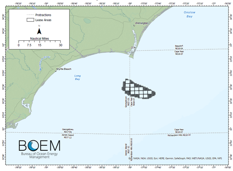
Even as Gov. Roy Cooper sets ambitious goals for electricity production from green sources like wind energy, a growing contingent of coastal communities are pushing back with “not in my backyard” concerns. The complicated, long-running story of wind energy off the Carolinas goes back to 2014 when the federal government’s Bureau of Ocean Energy Management (BOEM) first laid it on the table. Now, the effort faces a July 2022 deadline before all offshore energy leases – including oil, natural gas and wind – will be banned in the Atlantic Ocean. BOEM has proposed two areas off Brunswick County for wind turbine leasing by private companies. The areas account for shipping, military interests, fishing, water depth, average wind speeds and proximity to the electric grid, among other factors. Areas off of Brunswick and Horry, South Carolina counties are called Wilmington West (52,000 acres) and Wilmington East (134,000 acres). BOEM has announced no specific timeline for offering leases for those areas. For administrative purposes, they are grouped with other areas off the South Carolina coast. The East area starts slightly more than 11 nautical miles offshore; the West area begins 15.5 nautical miles off the Brunswick coast. The concept of limiting proximity of turbines to the shore started with the 70-mile-long Cape Hatteras National Seashore, which borders a proposed offshore lease area called Kitty Hawk. Managers of the federal lands asked that wind turbines be at least 24 nautical miles offshore to preserve the viewshed of the first federally protected seashore in the United States. Development is not allowed in the seashore, except for established municipalities and historic sites, access areas and a few minimal facilities, such as restrooms and trash containers. Leaders of village council at Bald Head Island picked up on that number, and council passed a resolution requesting the same 24-mile buffer zone and Ocean Isle Beach, Sunset Beach and Caswell Beach have passed similar resolutions. The Commonwealth of Virginia has made a parallel request. Oak Island Mayor Ken Thomas said his town council will also soon be asked to consider the measure. “I am in favor of wind power,” Thomas said. “I just don’t want to see it or hear it from the beach. I don’t know what the right number is; I just don’t want to see or hear them.”
More wind power
Last month, Gov. Cooper issued an executive order calling for the state to invest more in wind energy and move away from fossil fuels for electricity. “Offshore wind power will help North Carolina create jobs and generate economic development while helping us transition to a clean energy economy,” Cooper said in a prepared statement. “North Carolina’s national leadership in clean energy and manufacturing plus our highly trained workforce create a strong business environment for offshore wind supply chain and manufacturing companies.” The order establishes offshore wind development goals of 2.8 gigawatts off the North Carolina coast by 2030 and 8 GW by 2040. Achieving these goals will power roughly 2.3 million homes by 2040. In addition to creating economic benefits across North Carolina, the development will help achieve the North Carolina Clean Energy Plan goal of a 70-percent reduction in power sector greenhouse gas emissions by 2030 and carbon neutrality by 2050, the governor stated. “This coordinated approach to developing our offshore wind supply chain will bring new jobs to North Carolina for generations to come,” state Commerce Secretary Machelle Baker Sanders said in a prepared statement. “From building out the supply chain, to installing equipment, to operating the wind facilities, North Carolina’s manufacturers and workforce are well positioned to play an integral role in the entire East Coast market, not just for projects directly off the state’s coast.
Other players
A bipartisan group of North Carolina U.S. representatives endorsed federal efforts to develop offshore wind energy. Seven members of Congress – more than half the delegation – stated in April they wanted to act quickly and avoid a decade-long moratorium on new wind energy leases set to begin July 2022. Signers included U.S. Rep. David Rouzer, whose 7th District includes Brunswick and New Hanover counties. The letter from two Republicans and five Democrats acknowledges a recent study commissioned by the N.C. Department of Commerce that found tremendous potential for growth in offshore wind generation. The study stated, in part, that North Carolina could generate far more energy than the state is projected to use in 2035 and could capture future investments exceeding $100-billion in the wind energy business. The study, by industry consultants and N.C. State University, details how North Carolina’s existing ports and other infrastructure could support expansion of wind energy and provides a blueprint for long-term improvements. The letter from the Congress members asks BOEM to promptly and responsibly advance existing lease areas and identify new ones, if possible. “The way forward is, as Rep. Rouzer says, ‘All of the above’ with one caveat. Fossil fuels are a dead end and we need to leave that street as quickly as we can. Down the road the bridge is out,” said Pete Key, president of Brunswick Environmental Action Team. “I again applaud Governor Cooper’s bold leadership in protecting our planet,” said Randy Sturgill, field representative for Oceana, the largest ocean environmental group in the world. “This North Carolina executive order will help move forward the development of offshore wind in North Carolina. Offshore wind should be part of the climate solution and can be done in a responsible manner that ensures protections for critically endangered species like the North Atlantic right whale.”
Read more » click here
Previously reported – August 2021
Prospect of visible ocean wind farms unites Brunswick towns in opposition
The opposition movement began earlier this summer in Bald Head Island. The village council approved a resolution in May that makes it clear any efforts to place wind farms within the island’s viewshed – the territory of ocean in which the turbines could be seen from the beach, or the Old Baldy lighthouse – will be met with a fight. The campaign spread to neighboring coastal towns, with Ocean Isle Beach and Sunset Beach passing similar resolutions in July. With the tourism economy in mind, beach-town politicians across Brunswick County feared if an offshore wind farm were visible from the shoreline, it would deter would-be beachgoers and corrupt views. As stated in the Bald Head resolution: “Such a change would represent for us the most destructive commitment of ocean resources that we have ever heard proposed in North Carolina – one that could irreversibly damage the natural environment and resources that we cherish and that drive our economy.” The Brunswick County Board of Commissioners added to the chorus Monday, approving a resolution that says allowing wind farms within 24 nautical miles of the coast would damage tourism and the county’s economy by “transforming open ocean views to views of massive industrial machinery.” Meanwhile, the federal government is ramping up plans for the renewable energy source in waters offshore of the east coast. Last week the U.S. Bureau of Ocean Energy Management (BOEM) began the process of kickstarting an environmental review for a “wind lease” in the Atlantic Ocean off the coast of the Outer Banks. Wind developers pay the bureau for exclusive rights to huge chunks of ocean territory in cases like this where they’re looking to install offshore energy sources. North Carolina only has jurisdiction for 3 miles beyond the coastline. The Kitty Hawk wind farm will consist of up to 69 wind turbine generators if approved; it’s part of the Biden administration’s effort to create 80,000 jobs through the development of 30 gigawatts of offshore wind energy by 2030. BOEM also has its sights on two other portions of ocean domain in the vicinity of North Carolina – one called the “Wilmington East” wind energy area and the other called “Wilmington West.” The two zones identified by the federal government as suitable territories for offshore wind farms. Wilmington East (Blue) starts approximately 15 miles south of Bald Head Island. The rub for the coastal towns of Brunswick County is that Kitty Hawk’s wind farm was buffered at least 24 nautical miles out into the ocean at its closest point to shore. In most places, it is at a far greater distance, making it impossible for locals and Outer Banks tourists to see the turbines from the coast. The two wind energy areas offshore of Brunswick County, however, are a different scene. The Wilmington West area begins about 10 nautical miles from shore, and the Wilmington East area starts about 15 nautical miles south of Bald Head Island. “I think we need to go on record as having concerns,” Ocean Isle Beach Mayor Debbie Smith said at a July board of commissioners meeting when the resolution was discussed. “And we need to follow up and keep that pressure.” BOEM is in the planning stages for potentially issuing new leases offshore of the Carolinas. In July the bureau hosted a task force meeting with intergovernmental stakeholders. The Wilmington East area, in particular, is being considered for a lease sale, and BOEM is also seeking comment on whether to consider Wilmington West for a lease sale. BOEM anticipates holding an auction for an offshore lease in the Carolina region next year, according to a bureau spokesperson. The push from BOEM to get new projects like Kitty Hawk off the ground dovetails with Gov. Roy Cooper’s intentions. He signed an executive order in June with the goal of making N.C. a state friendly to wind farm development. It targets development of 2.8 gigawatts of offshore wind energy resources by 2030 and 8 gigawatts by 2040. “Offshore wind power will create jobs and help the state develop a clean energy economy,” a spokesperson for Cooper wrote in an email. “Governor Cooper’s Executive Order 218 sets a vision for offshore wind development to move the state to a clean energy future and increase supply chain and manufacturingopportunities.”
Read more » click here
County pushes back on offshore wind turbines
Brunswick County Commissioners want any offshore wind turbines built off of local beaches to be at least 24 nautical miles away, so they don’t impact tourism and the view of the coast. Commissioners unanimously adopted a resolution Monday in opposition to any wind energy leases within 24 nautical miles of North Carolina’s shoreline. They want the same protections the federal government’s Bureau of Ocean Energy Management (BOEM) has established for the State of Virginia and other areas of coastal North Carolina. BOEM established a 24 nautical mile no-leasing buffer for Virginia’s coast and the Kitty Hawk area in North Carolina, plus a 33.7 nautical mile buffer to protect the Bodie Island Lighthouse. “Wind turbines located within the viewshed of Brunswick County beaches would damage tourism and the economy of the county by transforming open ocean views to views of massive industrial machinery,” the resolution adopted Monday states. It adds, “Such a change would represent a destructive commitment of ocean resources that could irreversibly damage the natural environment and resources that drive our economy.” BOEM has proposed two areas off Brunswick County for wind turbine leasing by private companies. Areas off of Brunswick and Horry (South Carolina) counties are called Wilmington West (52,000 acres) and Wilmington East (134,000 acres). There is no timeline for offering leases for these areas. The East area starts slightly more than 11 nautical miles offshore; the West area begins 15.5 nautical miles off the Brunswick coast. Commissioners asked staff Monday to send the resolutions to Brunswick County municipalities. Towns that have adopted similar resolutions include Bald Head Island, Ocean Isle Beach, Sunset Beach and Caswell Beach. Oak Island is also expected to consider the matter at an upcoming meeting. Gov. Roy Cooper last month issued an executive order calling for the state to invest more in wind energy and move away from fossil fuels for electricity. Some members of Congress have also stated they want to act quickly and avoid a decade-long moratorium on new wind energy leases set to begin in July 2022. The county’s resolution states BOEM “has not analyzed the visual impacts of wind turbines on Brunswick County and will likely not do so until it is too late to reasonably do anything about wind turbine distance from shore.” It states the county is committed to challenge any BOEM issuance of wind energy leases within the visual impact area. It calls on Gov. Cooper, N.C. Department of Environmental Quality Secretary Elizabeth Biser, and the N.C. General Assembly to protect the state’s ocean viewshed from leases within 24 nautical miles off the shore.
Read more » click here
BOEM seeks comment on more NC, SC wind leasing options
The Bureau of Ocean Energy Management is considering a lease sale for the Wilmington East Wind Energy Area, or WEA, offshore of the North Carolina-South Carolina border. BOEM is preparing a supplemental environmental assessment to consider the additional wind leasing options for the area. The agency said Friday it will accept comment for the next 30 days ending at 11:59 p.m. Sept. 12. To comment and for a copy of the 2015 environmental assessment, visit https://www.boem.gov/renewable-energy/state-activities/north-carolina-activities. “Environmental reviews are essential to a strong resource management program,” said BOEM Director Amanda Lefton in a statement. “At BOEM, scientific based decision-making remains a top priority and will inform the path forward offshore the Carolinas. We welcome and appreciate your input into this process.” The supplemental assessment is to consider new information relevant to environmental considerations that were not available when BOEM published the Commercial Wind Lease Issuance and Site Assessment Activities on the Atlantic Outer Continental Shelf Offshore North Carolina – Revised Environmental Assessment in 2015. As part of this public process, BOEM said it is seeking input on additional information, issues and alternatives to be considered in the supplemental assessment. BOEM’s 2015 assessment considered the lease sale of the Kitty Hawk Wind Energy Area, as well as the Wilmington East and West WEAs. Officials said that BOEM found at the time that no reasonably foreseeable significant impacts were expected as a result of the proposed lease sales or any of the alternatives in the environmental assessment. BOEM held in 2017 an auction for the Kitty Hawk WEA and is now considering a lease sale for the Wilmington East WEA. The supplemental environmental review evaluates new circumstances and information relevant to reasonably foreseeable environmental impacts that would occur from site characterization activities such as shallow hazards, surveys of the lease area and potential cable routes as well as site assessment activities including installation and operation of meteorological buoys associated with issuing wind energy leases in the Wilmington East WEA. Some of the new information includes a recent marine cultural resources survey, changes in the status of some Endangered Species Act-listed species, the listing of new species, and the designation of critical habitat for the North Atlantic right whale.
Read more » click here
Previously reported – September 2021

Offshore North Carolina Visualization Study
Background:
During BOEM’s North Carolina offshore wind planning process, the need for accurate representations of offshore wind turbines to help evaluate potential visual impacts became apparent.
In cooperation with the National Park Service, the Bureau of Ocean Energy Management (BOEM) contracted with Mangi Environmental Group and its subcontractors, T.J. Boyle Associates and LPES, Inc., to undertake a visualization study. This effort involved the creation and development of photo documentation, photomontages, and videos to provide an accurate representation of the appearance of offshore wind facilities from a variety of locations along the coast of North Carolina.
In total, 234 offshore wind turbine simulations were created. Each simulation consists of an array configuration of 200 turbines and utilizes 1,000-meter turbine spacing.
The simulations included:
-
-
- 18 different locations (from Corolla Lighthouse to Sunset Beach);
- Four lighting conditions (morning, afternoon, starlit night, and misty nights);
- Three distances (10, 15, and 20 nautical miles [nm] from shore); and
- Two turbine models (Siemens 3.6 MW and Vestas 7 MW).
An overview location map of this information can be found here
This effort also included an analysis of the meteorological conditions along the coast of North Carolina. This analysis was an integral part of the study. The report can be foundhere.
A presentation outlining the technical aspects of the study can be found here.
Photo and Video Simulations:
Below are two matrices with links to the photo simulations and the 30-second video simulations. The matrices show each simulation’s viewing location, distance from the viewing location, the lighting condition, and the turbine type simulated.
Matrix of Photo Simulations Conducted In North Carolina
017 Holden Beach – Mockup photographs of wind farms at various distances
Read more » click here
Brunswick officials’ worries over offshore wind unresolved
Brunswick County beach towns are back to square one in a push to ensure potential offshore wind farms are out of the line of sight from shore. “Nothing has changed,” said Village of Bald Head Island Councilor Peter Quinn. “We’re still in the exact same situation. Nothing has been addressed.” The village council first adopted a resolution in 2015 urging the Bureau of Ocean Energy Management, or BOEM, to establish a buffer for offshore wind energy leases no closer than 24 nautical miles, or about 27 miles, off North Carolina’s southern coast. In May, councilors once again passed a similar resolution, a move that triggered other beach towns in the county, including Sunset Beach, Ocean Isle Beach, Caswell Beach, most recently, Oak Island, and the county board of commissioners to follow suit. As opposition mounts along North Carolina’s southernmost coast to wind turbines within the viewshed, or line of sight from shore, the federal government is ramping up proposed plans for what could be the first wind energy farms off the state’s coast. BOEM earlier this month began hosting a series of virtual public meetings as part of the agency’s environmental review of the proposed project’s construction and operations plans. In all, three wind energy areas, or WEAs, spanning more than 307,000 acres have been identified off the state’s coast for potential commercial wind energy development. These areas include the Kitty Hawk WEA, Wilmington West WEA and Wilmington East WEA, the latter two of which are off Brunswick County’s ocean shoreline. BOEM has established a 24-nautical-mile no-leasing buffer for Virginia and the Kitty Hawk WEA. A 33.7 nautical mile no-leasing buffer has been established to protect the Bodie Island Lighthouse. Meanwhile, the proposed lease sites offshore of Brunswick County are considerably closer to the coast, raising concerns about how the potential for hundreds of wind turbines towering over the ocean and changing the view of the horizon from shore might impact, among other things, tourism. As it stands, the closest border of the Wilmington West WEA is 10 nautical miles from shore. The Wilmington East WEA would be as close as about 15 miles from Bald Head Island. John Filostrat, director of public affairs of BOEM’s Gulf of Mexico region, said in an email response to Coastal Review that BOEM is preparing a proposed sale notice that will identify potential lease areas in the Wilmington East area. A draft of the proposed sale was discussed in July at a meeting of the Regional Carolina Long Bay Intergovernmental Renewable Energy Task Force. “BOEM anticipates holding an auction in the Carolina Long Bay region next year,” Filostrat said in the email. “Any potential lease sale would be informed by science and other information collected from the Carolina Long Bay Intergovernmental Renewable Energy Task Force, ocean users, and key stakeholders. He explained that BOEM’s environmental review process includes potential impacts of wind turbines within viewsheds. “Visual impacts are one of many resources that BOEM evaluates through its National Environmental Policy Act (NEPA) process,” he said. “BOEM requires all offshore wind project proposals (as detailed in an offshore wind developer’s Construction and Operations Plan) to include viewshed mapping, photographic and video simulations, and field inventory techniques, as appropriate, so that BOEM can determine, with reasonable accuracy, the visibility of the proposed project from shore. Simulations should illustrate sensitive and scenic viewpoints.” Property owners and visitors to Block Island, a small island a little more than 10 miles south of mainland Rhode Island, have a front-row view of the first commercial offshore wind farm in the United States. The 840-foot-tall turbines are little more than 3½ miles offshore. “We’re right at ground zero,” said Block Island property owner Rosemarie Ives. The 30-megawatt wind farm is operated by Orstead, a Denmark-based company. The wind farm’s five turbines became operational in December 2016. They generate enough energy to power 17,000 homes, according to Orstead. Block Island, once powered by five diesel generators, is now powered entirely by offshore wind, according to information provided on the company’s website. The island’s local government board, the New Shoreham Town Council, supported the project. The response among property owners – there are about 1,000 year-round residents on the island – and tourists have been a mixed bag. Ives and her husband were part of a handful of property owners, including a family on the mainland, thrust into the spotlight as they fought the project. Three months out of the year, they leave their home on the West Coast to vacation at the cottage, which sits atop the island’s bluffs, offering a panoramic view from south to east. During a recent telephone interview, Ives described the scene from the cottage, one that has been in her husband’s family since 1924. “We get to see all five of (the turbines) and they’re not moving one inch today because there’s absolutely no wind,” she said. “I remember the first time we came here in 1967 and I thought, oh my God, this is like nothing else. I think it was almost hypnotizing. It used to be quite majestic. It’s not the same.” Now, the dark sky that stretched over the ocean is peppered with blinking lights on the turbines. “You’re not having the experience of seeing the ocean rise above,” she said. “There’s something spiritual, magical about looking out and seeing the ocean and seeing the sky and now you’re seeing these turbines that are right there.” She describes the process for which the wind farm was approved “complex” and “convoluted,” one that she said inflates the project’s touted benefits. Ives is a former mayor of Redmond, Washington, for 16 years, to be exact. She chaired the U.S. Conference of Mayors Sustainability Task Force, and was an initial signatory of the Mayors Climate Protection Agreement. She refers to her background with an emphasis that she’s not anti-renewable energy. “I was green way, way befre it was politically correct,” she said. There’s a seemingly similar sentiment among those in Brunswick County asking for the buffer. When the Holden Beach Property Owners Association adopted in 2018 a resolution asking BOEM for the buffer, its members were intent on making sure it was not worded in a way that could be construed as anti-renewable energy. “We debated all that and tweaked the wording to make sure we didn’t across as anti-wind,” said Tom Meyers, the association’s president. “We’ve been mostly focused on the view from the beach strand. It’s the lights as much as what we’ll see in the day. We’re all on the same page. When you go out to the ocean and you look out at the night you just want to see the sky. I really wish the town would pass a resolution and take a stand here. Once you’re changing the view from the beach you’re impacting a lot.”
Read more » click here
Offshore wind in NC is focus of new coalition
A new coalition of organizations that work to protect North Carolina’s environment is turning its attention to offshore wind. The Offshore Wind for North Carolina coalition, or OSW4NC, aims to advance offshore wind in North Carolina, Southeastern Wind Coalition announced Tuesday. The coalition intends to engage residents, businesses, and state and federal leaders to encourage the opportunities that offshore wind presents, “and urge state and federal governments to move forward with policies necessary to reap the full suite of benefits of its offshore wind potential,” officials said. “This includes removing market barriers to offshore wind power, evaluating future wind energy areas off North Carolina’s coast, and ensuring offshore wind is developed in an environmentally responsible manner.” Founding organizations include Audubon North Carolina, the Chambers for Innovation and Clean Energy, the Environmental Defense Fund, Environmental Entrepreneurs, the North Carolina Coastal Federation, the North Carolina Conservation Network, the North Carolina League of Conservation Voters, the North Carolina Sustainable Energy Association, Sierra Club North Carolina and the Southeastern Wind Coalition. OSW4NC supports the offshore wind targets Gov. Roy Cooper established through Executive Order 218, including offshore wind energy targets of 2.8-gigawatts by 2030 and 8.0-gigawatts by 2040. The National Renewable Energy Laboratory estimates North Carolina has the highest technical potential for offshore wind generation among Atlantic coast states, officials with Southeastern Wind Coalitionsaid.
Read more » click here
Previously reported – October 2021
Biden Administration Plans Wind Farms Along Nearly the Entire U.S. Coastline
Interior Secretary Deb Haaland announced that her agency will formally begin the process of identifying federal waters to lease to wind developers by 2025.
Speaking at a wind power industry conference in Boston, Interior Secretary Deb Haaland said that her agency will begin to identify, demarcate, and hope to eventually lease federal waters in the Gulf of Mexico, Gulf of Maine and off the coasts of the Mid-Atlantic States, North Carolina and South Carolina, California, and Oregon, to wind power developers by 2025. The announcement came months after the Biden administration approved the nation’s first major commercial offshore wind farm off the coast of Martha’s Vineyard in Massachusetts and began reviewing a dozen other potential offshore wind projects along the East Coast. On the West Coast, the administration has approved opening up two areas off the shores of Central and Northern California for commercial wind power development. Taken together, the actions represent the most forceful push ever by federal government to promote offshore wind development. “The Interior Department is laying out an ambitious road map as we advance the administration’s plans to confront climate change, create good-paying jobs, and accelerate the nation’s transition to a cleaner energy future,” said Ms. Haaland. “This timetable provides two crucial ingredients for success: increased certainty and transparency. Together, we will meet our clean energy goals while addressing the needs of other ocean users and potentially impacted communities.”
Read more » click here
Previously reported – December 2021
Draft environmental assessment for wind leasing out for review
The federal Bureau of Ocean Energy Management on Wednesday released a draft supplemental environmental assessment related to its plan announced in August to update the environmental review of proposed wind leasing options off the North Carolina coast. The release opens a 30-day public comment period on the draft assessment. Comments are due by 11:59 p.m. Jan. 7. BOEM is proposing a lease sale for the Wilmington East Wind Energy Area, or WEA, in the Carolina Long Bay Area offshore North Carolina and South Carolina. The proposed area is about 127,865 acres and includes the majority of the Wilmington East WEA, which officials said has the potential to produce 1.5 gigawatts, or enough to power more than 500,000 homes. BOEM had said the update of the environmental review would factor in new information relevant to environmental considerations that were not available in 2015 when Commercial Wind Lease Issuance and Site Assessment Activities on the Atlantic Outer Continental Shelf Offshore North Carolina – Revised Environmental Assessment was released. BOEM is hosting two virtual public meetings to provide an overview of the supplemental assessment and to obtain public input. The meetings are set for 1 p.m. Dec. 14 and 5 p.m. Dec. 15. Ways to comment and more information on the meetings can be found on the BOEM website.
Read more » click here
Feds Release Draft Assessment For ‘Wilmington East’ Offshore Wind Plan
The possibility of wind turbines off Southeastern North Carolina shoreline is coming into focus as federal and state interests signal strong support for advancing clean energy initiatives. Meanwhile, local concerns over adverse visual impacts persist. The Bureau of Ocean Energy Management (BOEM) released a draft environmental assessment Wednesday, providing an updated overview of anticipated impacts prompted by potentially leasing the Wilmington East Wind Energy Area, roughly 128,000 acres offshore located about 17 miles from Bald Head Island. Up to three companies could lease the region, as outlined in BOEM’s proposed sale notice issued Nov. 1. Should a lease be awarded, the patch of ocean could generate 1.5 gigawatts (GW) of offshore wind energy, enough to power half a million homes, according to BOEM estimates. That would get North Carolina more than halfway to its goal of 2.8GW of offshore wind energy by 2030, detailed in Gov. Roy Cooper’s Executive Order 218, issued in June. The governor’s commitment to clean energy was further christened through his signing of House Bill 951 in October, which orders state utility regulators to come up with a plan to cut carbon emissions by 70% by 2030. Duke Energy (NYSE:DUK) – which supports the latest clean energy legislation – is considering entering the wind energy realm by applying to lease Wilmington East. CEO Lynn Good first acknowledged the company’s interest in the area in its third quarter earnings call last month, as reported by WUNC. In an emailed statement, Duke Energy spokesperson Jennifer Garber said the company is committed to achieving its own net-zero carbon emissions goal by 2050 as it transitions its infrastructure to cleaner energy sources. “As we evaluate the potential for offshore wind and other next generation clean energy technologies … we will engage members of the communities we serve,” she wrote. The company does not have experience with offshore wind leases. It does, however, have wind experience on land through its unregulated renewables subsidiary, Duke Energy Sustainable Solutions. The spin-off owns and operates 23 wind farms across the country, according to Garber. North Carolina’s foray into offshore wind energy advanced with BOEM’s first leased offshore wind area, Kitty Hawk, a 122,000-acre span roughly 27 miles from Corolla. Avangrid Renewables, a subsidiary of Avangrid Inc. (NYSE:AGR), won a $9 million bid to lease the space, which first went into effect in 2017. Last December, the company submitted its construction plan and is awaiting BOEM approval before work commences. The company did not immediately return an inquiry seeking to determine whether it was also interested in leasing WilmingtonEast.
Local opposition
Wilmington East has opposition from some of its nearest local government neighbors. Work investigating the area began in 2014, when it was included alongside Kitty Hawk and a section closer to the Brunswick shoreline. Both Wilmington sections were nixed due to shoreline sight concerns, with Wilmington West also located in a right whale critical habitat. Local governments have objected to the plans to erect turbines in the Wilmington East area for years. Of chief concern to the local communities is a disruption of views. When crafting the Kitty Hawk area, BOEM pushed back the offshore area’s setback to about 39 miles, upon the request of the National Parks Service, to avoid visual impacts to the Bodie Island Lighthouse. A similar, repeated request from local governments of a minimum distance of about 27 miles offshore has not been incorporated in BOEM plans to date. BOEM did not immediately return a request to comment. “We have raised this objection persistently since at least 2015, with no response or clarification from BOEM regarding how it may (or may not) address the concern,” Village of Bald Head Island Mayor Andy Sayre wrote in his Sept. 12 comments on the proposed sale notice. “This is unacceptable.” Wilmington East begins about 17 miles offshore. As currently planned, there would be no visual impacts caused by meteorologic buoys installed in the area, according to the draft assessment. Meteorologic towers were initially considered in a 2015 assessment, but the industry has strayed from towers in favor of buoys, which reduce ocean and visual impacts. A full study on actual turbines would be forthcoming, after a lease is awarded. This summer, Caswell Beach, Sunset Beach, Ocean Isle Beach, Bald Head Island, and Brunswick County each adopted resolutions, calling for a 27-mile setback for offshore wind resources. Should BOEM take heed of this request, it would “turn potential opponents into supporters,” Sayre wrote. Brunswick County will review the draft environmental assessment, according to its spokesperson, but has no immediate plans to comment on it; Bald Head Island intends to comment on the assessment, according to its spokesperson. Economic, environmental positions still forming Wilmington Chamber of Commerce CEO Natalie English – who on Tuesday accepted a Clean Energy Champion Award from the Chambers for Innovation and Clean Energy and served as co-chair on Mayor Bill Saffo’s Clean Energy Task Force – said the chamber is still developing its position on the proposal to lease Wilmington East. “Our legislative agenda supports legislative action to reduce carbon emissions, modernize the grid, and keep energy prices as affordable as possible,” English wrote in an email. “We are very intrigued by the potential for investment and job growth in our region that would come with the leases. We have plans to consider the proposals in more detail early in 2022.” The N.C. Coastal Federation is meeting Friday to discuss and develop its stance on wind energy in general, according to coastal advocate Kerri Allen. The federation supports “responsible offshore wind development,” according to its website. The comment period on the proposed sale notice closes Jan. 3. To submit a comment on the supplementary environmental assessment released Wednesday, interested parties may comment online or attend two virtual public meetings. The first will be held Dec. 14 at 1 p.m., and the second will be held the following day, Dec. 15 at 5 p.m. Comments will be accepted through noon on Jan. 7.
Read more » click here.
Push for wind farm off Wilmington’s coast continues despite local concerns
The proposed development could go a long way to meeting the state’s offshore wind energy goal
Bill Franks squinted his eyes on a sunny and unusually warm mid-December day and looked out into the Atlantic from the sandy shore of Caswell Beach. “I support clean energy, so they would be good to have,” said the Michigan resident, visiting family in Brunswick County for the holidays, when asked if having wind turbines in the near-shore waters off the North Carolina coast would alter his view of vacationing here. “But I just don’t know. I guess it depends on what they’d look like from here.” That’s the rub for many coastal officials in this pocket of Southeastern North Carolina. While most have said they openly support the push to a carbon-free energy future, they also don’t want to kill the golden goose of their economies – namely the oceanfront views that draw tourists and an increasing number of fulltime residents to their beach towns. A new supplemental environmental assessment is likely to do little to alleviate concerns of coastal officials and residents worried the development of the Wilmington East Wind Energy Area, roughly 17 miles south of Bald Head Island, could ruin views from their oceanfront communities. With clean energy near the top of the agenda for President Joe Biden and North Carolina Gov. Roy Cooper, the federal government this month released an updated environmental report on potential impacts of a proposed wind farm off the Brunswick County coast. The move by the federal Bureau of Ocean Energy Management (BOEM) highlights the push to get offshore wind farms, which have been mired in changing political winds in recent years, in the water, with the agency suggesting a lease could be issued as soon as mid-2022. The new assessment, which is open for comment until Jan. 7, recommends dividing the Wilmington East area, which covers nearly 128,000 acres, into three lease areas instead of one. According to BOEM, the site could generate up to 1.5 gigawatts (GW) of energy, enough to power up to 500,000 homes. Cooper has said he’d like to see offshore wind generate 2.8 GW for the state grid by 2030. The report also includes additional comments about the North Atlantic right whale, one of the most endangered animals in the world. According to the New England Aquarium, the whale’s population dropped to 336 in 2020, an 8% decrease from 2019. The marine mammal is known to travel through the area proposed for the Wilmington wind farm. The report recommends removing some areas from the initial lease area to reduce potential whale-industry impacts.
‘Transforming’ ocean views?
But the report offers little new to ease the concerns of local officials worried about potential visual pollution from the proposed farm. The draft assessment notes that industry has moved away from meteorological towers, which were initially proposed in an earlier assessment to help assess wind and other weather factors, to buoys that have little to no visual impacts. It is expected a look into the visual impacts from the actual wind turbine towers, which can extend more than 500 feet from the ocean surface to the top tip of the blade, would occur later in the review process. The Wilmington East site was one of three areas initially identified by regulators as possible sites for offshore wind farms. A proposed site closer to the Brunswick shore, dubbed Wilmington West, has been dropped due to visual pollution concerns. But the third site, off the Outer Banks, is moving forward, with the 122,000-acre parcel leased to Avangrid Renewables in 2017. Construction plans have since been submitted to BOEM for its review. The Outer Banks site, roughly 26 miles east of Kitty Hawk, also raised shoreline sight concerns when first proposed, including from the National Park Service. The result was the farm was pushed farther from the coast. Brunswick County officials have requested a similar modification for the Wilmington East project, so far with little success. On Aug. 3, the Brunswick County Commissioners joined the county’s beach towns in adopting a resolution opposing any wind turbines located within 24 nautical miles (27 miles) of the coast. “Wind turbines located within the viewshed of Brunswick County beaches would damage tourism and the economy of the county by transforming open ocean views to views of massive industrial machinery,” the resolution states.
Economic windfall?
Even as some officials ruminate over the potential negative impacts of offshore wind farms, others are looking at the possible economic shot the arm the industry’s arrival could bring to the region. One of those groups is the Wilmington Chamber of Commerce, which was recently recognized by the Chambers of Innovation and Clean Energy for its community discussions on the opportunities offered by the growth of the clean energy industry. Chamber CEO Natalie English said her organization has yet to take a position on the proposed Wilmington East wind farm. But the economic potential is hard to ignore. “We are very intrigued with the investment and job creation that might come along with the project,” English said via email. “We plan to learn more about the project in 2022.” Matt Abele, spokesman for the N.C. Sustainable Energy Association, said that while the idea of business friendly chambers of commerce embracing clean energy ideas might not come naturally to some, it makes perfect business sense. “Innovative chambers recognize the growth opportunities associated with clean energy, and see how fast the industry is growing,” he said, noting it already supports more than 112,000 jobs across the state. “And in some cases, they have been strong advocates and worked with their municipal leaders to promote those economic development opportunities.” That can be especially important when many of these new and emerging economic opportunities aren’t your typical, more traditional business developments, such as solar farms and – in the coast’s case – offshore wind, Abele added. With active offshore wind farm proposals for nearly all East Coast state between Massachusetts and Georgia, North Carolina could be well placed to capitalize on the growth of the emerging industry. A March 2021 presentation by the N.C. Department of Commerce, dubbed “Building North Carolina’s Offshore Wind Supply Chain,” highlighted the state’s industrial base already involved in wind turbine production and port facilities that could help it serve the offshore farms. Sites included the state ports of Wilmington and Morehead City, the state-owned undeveloped 600-acre tract north of Southport that was once proposed for an international port, and several smaller facilities in and around the Outer Banks. “This really is an exciting time for North Carolina and one that carries significant economic opportunities,” Abele said. “And if we can get a source of clean energy and some good quality jobs, it really is a win-win situation.”
Read more » click here
Previously reported – January 2022
Wind energy lease spots closest to beach eliminated
The new federal review of an area planned for wind energy eliminates spots closest to Brunswick County beaches and splits the remaining site into three pieces. The area considered for leasing – Wilmington East – starts about 15 nautical miles south of Bald Head Island. The new review incorporates information gleaned since the 2015 federal study, but the conclusions are the same – the Wilmington East site has tremendous potential to generate energy at no significant impact to the environment, tourism and fishing industries. It’s worth noting that the Kitty Hawk wind area lease (the other area in the Carolinas) will net $9 million in revenues to the government, even if wind turbines are not put into function. Granting the local lease would not be a done deal. There are a host of site-specific studies and permits needed to move forward with construction.
How they look
The updated supplement to the 73-page environmental assessment concludes that impacts to sea life, recreation and tourism would be minor at most. “The WEAs (wind energy areas) were designed to minimize effects on the viewshed and primary recreational resources; therefore, effects on tourism and recreation, as a result of meteorological tower and buoy placement, also were anticipated to be negligible to minor,” the report stated. The report also said, “the 2015 (study) concluded that the overall visibility of meteorological towers was expected to be relatively minimal when viewed from shoreline locations (occupying less than 1-percent of the visible seascape), even when viewed from higher elevations. Atmospheric haze reduces visibility and wave action can obscure objects very low on the horizon. Limits to human visual acuity also reduce the ability to discern objects at great distances, and nighttime lighting on the meteorological towers would be similar to lights visible from existing vessel traffic. The 2015 EA (environmental assessment) also concluded that meteorological buoys would not be visible from onshore locations. Based on the foregoing, the visual resource impacts associated with site characterization surveys and site assessment activities were anticipated to be negligible.” BOEM (Bureau of Ocean Energy Management) stated that this has not changed since the earlier assessment. The lease area does not include artificial reefs or area of concern by the Department of Defense and places considered critical to migration by North Atlantic Right Whales (one of the planet’s most-endangered species).
Mitigation and protection
BOEM stated it has incorporated several measures to respond to local concerns,including:
* Analysis of the potential harmful effects of wind power generation on birds and other fauna that depend upon the offshore ecosystem;
-
- Incorporating mitigation efforts in a lease agreement;
- Setting vessel speed restrictions;
- Analysis of the potential conflict with the Coast Guard’s proposed Atlantic CoastFairway;
- Engaging the local communities;
- Defining BMPs (Best Management Practices) throughout the regulatory process; and
- Enhancing the data collection for future offshore wind energy facility siting.
More background
There are two proposed lease areas, Wilmington East and Wilmington West, which are both offshore past the three-mile demarcation between state and federal waters. Brunswick County and several beach communities, including Oak Island, Caswell Beach and Bald Head Island, have asked the federal government to restrict wind turbine placement to no closer than 24 nautical miles from shore. Their concern is that windmills could detract from the viewshed of the beach. This request, if granted, precludes all of the Wilmington West lease area. The west area is not up for consideration at this time. What is on the table is Wilmington East, a 127,865-acre area that could be leased in three separate portions. BOEM stated that the Wilmington East area has the potential to produce 1.5-gigawatts of energy, enough to power 500,000 homes. Gov. Roy Cooper’s administration has stated it would like to see about twice that much wind power in the grid by 2030. BOEM has further stated that leasing agreements could include credits for local workforce training and improvements to the supply chain for wind energy. After the close of public notice, BOEM stated it would publish a final notice of sale. BOEM’s draft (report) assesses the potential impacts from the issuance of commercial leases within the Wilmington East lease area. Potential impacts include those that could occur from site characterization activities (shallow hazards, geological, geotechnical, archeological, and biological surveys of the lease area and potential cable routes) and site assessment activities (installation and operation of meteorological buoys) associated with issuing wind energy leases in the WEA. BOEM will accept public comment on the supplemental environmental assessment until midnight on Friday, January 7, 2022. Those who wish to comment should visit https://www.boem.gov and navigate to the renewable energy section associated with Carolina Long Bay.
Read more » click here
Previously reported – February 2022
Coalition answers wind turbine questions
The Southeastern Wind Coalition had an open house Jan. 28 to open a discussion on the Wilmington East Offshore Wind Plan turbine project. Many residents and experts gathered in a room in the Southport Community Building. There were photographic examples of Bald Head Island, Holden Beach and Oak Island beaches who would be closest to the turbine location. Southeastern Wind Coalition president Katharine Kollins said the turnout to the open house was phenomenal and better than she expected. “Folks are staying and talking and that’s really what we wanted,” she said. She said the coalition hosted the event so there could be good discussion among community members, environmental nonprofits, and anyone else to learn about offshore wind power, what it might look like and what it could mean to the community. “From what I’ve seen, people have just really come open-minded,” she said, explaining one of the coolest parts of the open house she has noticed. Kollins added she hasn’t seen anyone “vehemently against.” She said many came with questions about if the offshore turbines will hurt the birds or wildlife. Kollins said the turbines will be located outside of the migratory patterns, environmentally sensitive areas, and marine shipping lanes. These areas are “deconflicted areas” that were picked out about a decade ago by states, local committees, the Coast Guard, and other groups. There were also many questions on how they will handle hurricanes. Kollins said, “These things are clearly built to withstand some incredibly crazy weather.” She said offshore turbines are built to withstand a direct hit from a category three hurricane at a base level. She added there were instances in Asia with typhoons where the turbines withstood category four hurricanes. She said if the turbines were directly hit by a category 5 hurricane, nothing is going to survive that. She said a nuclear facility couldn’t even withstand that hit. Kollins said that’s an insurable risk that can be calculated and insurers are still willing to back it. She said the most interesting question she had gotten was where the electricity goes. She said she thought people would be much more concerned how this will impact their lives. However, people have told her that if these turbines are going to be set up off their coast, they want the electricity. Kollins said people said the Kitty Hawk Offshore Wind project might go to Virginia and this project’s electricity might go to South Carolina. “And we might not get the electricity in North Carolina,” she said, recalling what people told her. Kollins said she tells those people the project has to work with utility, utilities commission and residents need to work with the elected officials to let the officials know they want the electricity to go to North Carolina. “Because that’s where things actually happen,” she said. Kollins said to make sure the electricity comes to North Carolina, elected officials have to make sure the utility company can purchase offshore wind power, otherwise this electricity can go anywhere. So far, no decisions have been made. The electricity, which is transferred onshore through cables underwater and under the beach, won’t be decided on until after a wind energy area has been leased and after a buyer for that energy. She said the developer will determine the best electricity infrastructure on land to bring the power on land. Kollins added the developers usually chose places with that infrastructure already existing. Kollins said the most likely site, after doing some work with the North Carolina Transmission Planning Collaborative, will be New Bern. She said there is a large substation there that could take power from the Kitty Hawk Project and a Wilmington project. She said the point of this event was for people to come with open minds and learn. “You can’t ask for anything better than somebody who is willing to have a conversation and ask questions,” she said. Kollins said the staff is also learning what kind of questions those coming to the open house will have. Kollins said the coalition will gladly host more open houses to help spread information about the turbines. She said it doesn’t mean someone attending the open houses will leave loving off shore winds. But the residents’ can get answers and be able to voice concerns and who to talk to about those concerns. Kollins said the lease sale is expected to be in May and once there is a developer, this will be that company’s role. She said the Southeastern Wind Coalition is trying to fill that role for now.
For more information go to https://www.sewind.org/
Read more » click here
 Previously reported – April 2022
Biden-Harris Administration Announces Wind Energy Lease Sale Offshore theCarolinas
The Department of the Interior announced today that the Bureau of Ocean Energy Management (BOEM) has completed its environmental review and will hold a wind energy auction for two lease areas offshore the Carolinas on May 11. The lease areas cover 110,091 acres in the Carolina Long Bay area that, if developed, could result in at least 1.3 gigawatts of offshore wind energy, enough to power nearly 500,000 homes. The announcement is part of President Biden’s agenda to grow a clean energy economy that harnesses offshore wind projects to strengthen U.S. energy independence, create good-paying jobs, and lower energy bills for consumers. “The Biden-Harris administration is committed to supporting a robust clean energy economy, and the upcoming Carolina Long Bay offshore wind energy auction provides yet another excellent opportunity to strengthen the clean energy industry while creating good-paying union jobs,” said Secretary Deb Haaland. “This is an historic time for domestic offshore wind energy development. We will continue using every tool in our toolbox to tackle the climate crisis, reduce our emissions to reach the President’s bold goals, and advance environmental justice.” President Biden catalyzed the offshore wind energy industry by announcing the first-ever national offshore wind energy goal, creating a clear vision for the future of this innovative industry. This goal is reinforced by President Biden’s Bipartisan Infrastructure Law, which will make historic investments to build a better America with clean energy, resilient infrastructure, and strong domestic manufacturing and supply chains. The Carolina Long Bay offshore wind energy auction will allow offshore wind developers to bid on one or both of the lease areas within the Wilmington East Wind Energy Area (WEA), as described in BOEM’s Final Sale Notice (FSN), which is available today in the Federal Register Reading Room. The two lease areas include similar acreage, distance to shore, and wind resource potential. The FSN includes several lease stipulations designed to promote the development of a robust domestic U.S. supply chain, advance flexibility in transmission planning, and encourage project labor agreements. Among the stipulations announced today, BOEM will offer a 20 percent credit to bidders if they commit to invest in programs that will advance U.S. offshore wind energy workforce training or supply chain development. To advance BOEM’s communication and environmental justice goals, the leases will also require lessees to identify Tribal Nations, underserved communities, agencies, ocean users and other interested stakeholders, and report on their communication and engagement activities with these parties. These stipulations are intended to promote offshore wind energy development in a way that coexists with other ocean uses and protects the ocean environment, while also facilitating our nation’s energy future for generations to come. These innovative stipulations were embraced in the Department’s recent lease sale for the New York Bight, which set a record as the nation’s highest-grossing competitive offshore energy lease sale in history, including oil and gas lease sales. “BOEM is focused on ensuring that any development offshore North Carolina is done responsibly, in a way that avoids or minimizes potential impacts to the ocean and ocean users in the region,” said BOEM Director Amanda Lefton. “The milestones announced today mark significant progress in achieving this Administration’s goal for deploying 30 gigawatts of offshore wind energy by 2030, while creating jobs and strengthening a sustainable domestic supply chain.” In November 2021, BOEM published a Proposed Sale Notice (PSN) and requested public comments on the proposed leasing of nearly 128,000 acres in the Wilmington East WEA. Based on the bureau’s review of scientific data and extensive input from the commercial fishing industry, Tribes, partnering agencies, key stakeholders, and the public, BOEM reduced the acreage available for leasing in the FSN by 14 percent from the areas proposed in the PSN to avoid conflicts with ocean users and minimize environmental impacts. BOEM will continue to engage with its partners and stakeholders as the process unfolds. In addition, this past fall the Administration announced a new leasing path forward, which identified up to seven potential lease sales by 2025, including the upcoming Carolina Long Bay lease sale and last month’s New York Bight lease sale. Lease sales offshore California and Oregon, as well as in the Central Atlantic, Gulf of Maine, and the Gulf of Mexico are expected to follow. A recent report indicates that the United States’ growing offshore wind energy industry presents a $109 billion revenue opportunity to businesses in the supply chain over the next decade. More information about the FSN, lease stipulations, the list of qualified bidders for the auction, and auction procedures can be found on BOEM’s”¯Carolina Long Bay website.
Read more » click here
Previously reported – May 2022
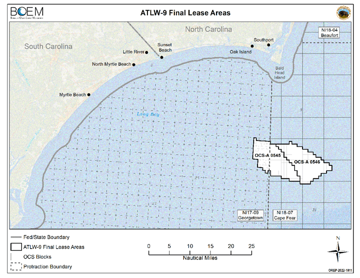
These two companies paid $315 million to develop wind energy off the Brunswickcoast
More than 110,000 acres off the Bald Head Island coast will soon be home to a wind turbine farm. The Bureau of Ocean Energy Management has auctioned off the two wind energy lease sites roughly 20 nautical miles from the coast of Brunswick County for a combined $315 million. Duke Energy Renewables Wind won the right to develop offshore wind on the eastern 54,154-acre site with a bid of $155 million. Total Energies Renewables USA bid $160 million to develop the 54,937-acre western site. The combined sites are expected generate 1.3 gigawatts of renewable energy if fully developed, enough to power about 500,000 homes. Last year, N.C. Gov. Roy Cooper announced a statewide goal to produce 2.8 gigawatts of offshore wind energy by 2030 and 8 gigawatts by 2040.
The auction comes at a time of increased urgency, as a looming 10-year moratorium on offshore wind energy development is set to take effect in July. Over the past year, several Brunswick municipalities have come out against the offshore leases, citing affects the visual impacts would have to the tourist-dependent economy. Brunswick County, Sunset Beach, Ocean Isle Beach, Caswell Beach and the Village of Bald Head Island have all passed resolutions opposing their construction. Charter fisherman have also questioned how the turbines might affect migratory fish and say the turbines are located in a popular fishing spots such as Southwest Tower Bottom and The Horseshoe. According to BOEM, they’ve responded to local concerns by reducing the wind lease area by 14%, making it less visible from the mainland, and requiring monitoring on migration patterns. The winning bidders also pledged to invest $42 million total in domestic supply chain and workforce training. A January 2022 study from the Southeastern Wind Coalition found that if the state reaches its 2.8-megawatt wind energy production goal by 2030, it will result in “a net economic benefit of up to $4.6 billion.” “Investments from two developers means increased supply chain investment and recruitment, workforce development and thousands of good-paying jobs, and infrastructure development that will support other North Carolina industries,” coalition president Katharine Kollins said in a release. An anti-competitiveness review of the auction will be conducted by the Department of Justice and Federal Trade Commission before the leases are finalized.
Read more » click here
Duke, TotalEnergies winning bidders in wind lease auction
Federal officials Wednesday auctioned two lease areas off the North Carolina and South Carolina coast, the second major offshore wind lease sale this year. The Department of the Interior announced results late Wednesday. The provisional winner for renewable energy lease No. OCS-A 0545, the westernmost, 54,937-acre section of the Carolina Long Bay area was TotalEnergies Renewables USA, LLC, which bid $160 million. Duke Energy Renewables Wind, LLC was the provisional winner for lease No. OCS-A 0546, a 55,154-acre area, with a $155 million bid. The winning bids each dwarfed that for the Kitty Hawk offshore wind lease auction five years ago. The Bureau of Ocean Energy Management says OCS-A 0545 and OCS-A 0546 together, if developed, could generate 1.3 gigawatts or more, enough to power nearly 500,000 homes.”¯Officials called the auction a significant milestone towards achieving the Biden-Harris administration’s goal of deploying 30 gigawatts of offshore wind energy capacity by 2030. “The Biden-Harris administration is moving forward at the pace and scale required to help achieve the President’s goals to make offshore wind energy a reality for the United States,” said Secretary Deb Haaland in the announcement. “Together with an all-of-government approach, we can combat the effects of climate change while creating good-paying union jobs that can benefit underserved communities. Today’s lease sale is further proof that there is strong industry interest and that America’s clean energy transition is here.” The Carolina Long Bay offshore wind auction included a new 20% credit for bidders, which commits to a monetary contribution to programs or initiatives that support workforce training programs for the offshore wind industry, development of a U.S. domestic supply chain for the offshore wind energy industry, or both. The credit will result in $42 million for the programs or initiatives, officials said. “This auction puts real dollars on the table to support economic growth from offshore wind energy development – including the jobs that come with it,” said BOEM Director Amanda Lefton. “The new bidding credit in the Carolina Long Bay auction will result in tangible investments for workforce training and businesses in the United States, to ultimately create jobs in the U.S. across the industries needed to support achieving our offshore wind goals.” Periodic updates on the auction, which began at 9 a.m. and wrapped up about 5 p.m., were posted at the BOEM website. Bidders could vie for one or both of the lease areas within the Wilmington East Wind Energy Area. The two lease areas include similar acreage, distance to shore and wind resource potential. The Carolina Long Bay wind energy area’s closest distance to shore is about 15 nautical miles. Federal officials have said the location and shape of the lease areas were drawn based on considerations such as vessel traffic patterns, North Atlantic right whale habitat, Defense Department considerations and visual concerns expressed in coastal communities. The Interior Department said that to advance its environmental justice goals, leaseholders are also required to identify Tribal nations, underserved communities, agencies, ocean users and other stakeholders and to report on those communications and engagement activities. “These stipulations are intended to promote offshore wind energy development in a way that coexists with other ocean uses, addresses potential impacts and benefits, and protects the ocean environment, while also facilitating our nation’s energy future for generations to come,” according to the announcement. Before the leases are finalized, the Department of Justice and Federal Trade Commission must conduct an anti-competitiveness review of the auction, and the provisional winners will be required to pay any balance on the winning bids and provide financial assurance to BOEM.
Read more » click here.
Previously reported – June 2022
NC governor joins state-federal offshore wind partnership
Gov. Roy Cooper has joined 10 other East Coast governors and the Biden administration in the new Federal-State Offshore Wind Implementation Partnership. An effort to accelerate offshore wind progress, the partnership, in addition to Cooper, includes the White House national climate adviser, the secretaries of the Interior, Energy, Commerce and Transportation, and governors of Connecticut, Delaware, Maine, Maryland, Massachusetts, New Hampshire, New Jersey, New York, Pennsylvania and Rhode Island, the administration announced June 23. “I think we’re at a place where we’re reaching an exciting point where it seems like there’s been a coalescence of notion that, you know, alternative energy makes sense, and wind is a gigantic piece of it,” Biden said last week before a meeting on this partnership. The partnership is intended to be a forum for new initiatives and to coordinate ongoing efforts to address ocean co-use, transmission needs and other offshore wind priorities that could benefit from more federal, state, and regional coordination. The partnership will look to expand to the West Coast and the Gulf of Mexico as offshore wind energy projects develop in those areas. Biden set a goal in March 2021 to deploy 30 gigawatts of offshore wind by 2030, which officials say is enough to power 10 million homes with clean energy, support 77,000 jobs, and spur $12 billion per year in private investment in offshore wind projects. States in the partnership have committed to develop a domestic offshore wind manufacturing and logistics network, a sustainable workforce, and to support local and domestic businesses, when possible, for products and services. Commitments on the federal level include timely and effective permitting and environmental reviews and use of the lease auction process to incentivize investing in the country’s offshore wind supply chain.
Read more » click here
Previously reported – November 2022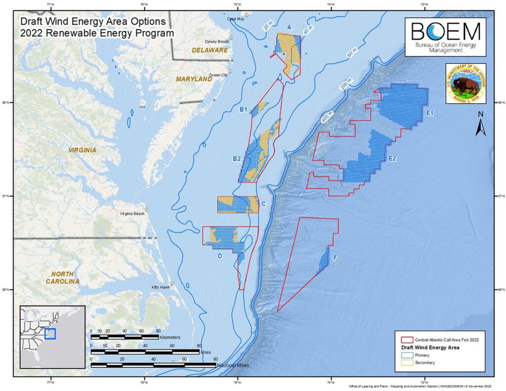 Public comment period opens on draft offshore wind areas
The federal Bureau of Ocean Energy Management on Wednesday announced that a 30-day public comment period has begun on eight draft offshore wind energy areas, including off the North Carolina coast.BOEM said it will hold virtual public meetings to engage the fishing community and environmental organizations to gather more information on the proposed areas and discuss next steps. The proposed areas cover about 1.7 million acres off North Carolina, Virginia, Maryland and Delaware. The distances to their closest points range from about 19 to 77 nautical miles offshore. “As BOEM moves forward to identify wind energy areas in the central Atlantic, we continue to prioritize a robust and transparent process, including early engagement with Tribal governments, state and federal agencies and ocean users,” said BOEM Director Amanda Lefton in a statement. “We want to gather as much information and traditional knowledge as possible to help us identify Wind Energy Areas – the offshore areas that are most suitable for commercial wind energy activities while having the fewest apparent environmental and user conflicts.” Environmental and energy advocates praised the announcement. “Today’s announcement lays the groundwork for additional offshore wind development in the Atlantic, which will help lower energy costs, create jobs, and fight climate change. Unlike dirty and dangerous offshore drilling that pollutes our waters, worsens the climate crisis, and harms frontline communities, offshore wind can support a just and equitable transition away from the fossil fuels that are driving the climate crisis,”³ said Oceana Campaign Director Diane Hoskins in a statement. “With growing offshore wind opportunities, the states along the Central Atlantic coast have a chance to become part of the next wave of offshore wind hubs. While these states will clearly benefit tremendously from jobs and investment associated with offshore wind development, the benefits will stretch across our nation,” said National Ocean Industries Association President Erik Milito in a statement. Federal officials said the process to identify the potential offshore locations considered areas that appear most suitable for renewable energy development. BOEM said it collaborated with the National Oceanic and Atmospheric Administration’s National Centers for Coastal Ocean Science to use an ocean planning model that seeks to minimize conflicts. The eight areas were carved out of the original 3.9 million acres that the Department of the Interior announced for public comment in April. Officials said the final areas may be further changed based on feedback from government partners, ocean users and stakeholders. BOEM seeks comment on potential conflicts, including with a potential U.S. Coast Guard “fairway” for transiting vessels, commercial fishing, a NASA danger zone, and marine habitat areas. BOEM said it intends to further explore the areas with the Department of Defense, Coast Guard, NASA and other ocean users, such as the fishing industry, to collect additional information that should be considered before finalizing the wind energy areas.
Meetings have been set for the following dates:
To comment on the draft wind energy areas, visit regulations.gov and search for docket number BOEM-2022-0072. BOEM will accept comments through 11:59 p.m. Dec. 16.
For more information visit:
https://www.boem.gov/renewable-energy/state-activities/central-atlantic.
Read more » click here
Previously reported – December 2022
Draft wind energy areas off NC coast may be downsized
Proposed central East Coast offshore wind energy areas, including two off the northern North Carolina coast, may be scaled back in size by the time they are finalized early next year.Sea scallop fishing, a NASA danger zone, a proposed shipping safety fairway, and marine habitat could further trim eight draft wind energy areas, or WEAs, the federal government is eyeing offshore from Delaware south to Cape Hatteras.These areas encompass about 1.7 million acres, a little less than half of the original 3.9 million acres the Interior Department identified as potential wind energy areas.Last month, the Bureau of Ocean Energy Management, or BOEM, opened a 30-day public comment period on the draft WEAs, including one area located about 28 miles offshore of southern Virginia and northern North Carolina and one about 50 miles from those coasts.BOEM hosted two virtual meetings last week, giving members of the fishing community and environmental organizations an opportunity to ask questions about and comment on the draft WEAs. Among some of the concerns raised during the meetings were potential impacts to Atlantic sea scallop fishing off Delaware’s coast and recreational fishing vessel businesses, possible effects on deep sea coral, and impacts to shorebirds and endangered right whales.One participant suggested BOEM include exclusion zones for right whales.”If these right whales are gone, that’s it. They’re gone forever,” he said.A representative with the Maryland Climate Action Network encouraged BOEM officials to move forward with examining the potential for wind development within secondary areas, where conflicts may exist, of the draft WEAs.In order to reach the country’s clean energy goals, we’re going to need as many acres as possible for offshore wind development, she said.Capt. Cane Faircloth, a resident of Brunswick County and president of the North Carolina For-Hire Captain’s Association, asked BOEM to take into consideration potential impacts to fishermen who hold operator of uninspected passenger vessels licenses.Operator of uninspected passenger vessel licenses, also called OUPVs or six-packs, allow recreational charter fishermen to carry as many as six passengers as far as 100 miles offshore. These licenses are the most popular issued by the Coast Guard.Peggy Schultz, a representative of Coalition POWER, which stands for People for Offshore Wind Energy Resources, out of Delaware, asked about the viability of deep-water offshore wind farms and whether floating turbines are in the planning stages in the U.S.”We really don’t know,” BOEM’s David MacDuffee, chief, projects and coordination branch said. “It really is a big question for BOEM on how viable these areas are.”He said floating turbines have been deployed in waters in other areas of the world, but that the technology is still new.Bridgette Duplantis, BOEM’s central Atlantic team lead, said companies that have indicated an interest in the proposed deep-water sites have said they expect a “longer timeline” for technology to be developed for areas farther offshore.BOEM says it will collect additional information about activities in the draft WEAs with the Department of Defense, U.S. Coast Guard, NASA and other ocean users, including the fishing industry before finalizing the areas. Once the final central Atlantic Ocean WEAs are selected, those areas will be environmentally assessed through the National Environmental Policy Act process.The final WEAs are expected to be published in the first quarter of 2023. The first lease sale is expected to occur about a year later, according to BOEM officials.Those lease sales will expand the wind energy footprint offshore of North Carolina.Plans are underway for a 2.5-gigawatt wind farm off Kitty Hawk. Avangrid, the company that won the lease sale of that WEA, has indicated construction could start in 2026 and eventually power as many as 700,000 homes.And, in May, Duke Energy and French company TotalEnergies won leases for sites south of Bald Head Island to the tune of more than $300 million.Energy produced at those sites could eventually power up to 500,000 homes.Development of these wind farms will help North Carolina close in on Gov. Roy Cooper’s goal for offshore wind to generate 2.8 gigawatts by 2030 and 8 GW by 2040, which would power some 2 million homes.BOEM is accepting comments on the draft WEAs through 11:59 p.m. Dec. 16. Comments may be made by visiting regulations.gov, docket number BOEM-2022-0072.
Read more » click here
Previously reported – August 2023
Survey work for offshore wind leases to start this month
Leaseholders for future offshore wind locations off the coast of Brunswick County will be performing survey work and collecting data this month. TotalEnergies and Duke Energy will be working in the area Aug. 16 to Aug. 31 to collect data for the future employment of met-ocean buoys within the Carolina Long Bay offshore wind lease areas. The survey activity is part of an early-stage evaluation process and expected to last three to five days, depending on weather conditions. The results of the survey will provide information required by the Bureau of Ocean and Energy Management for site assessment planning. The process of constructing offshore wind in the area, now announced at 17 nautical miles offshore, started in 2014, with final sales going through March 25, 2022. A recent report shows North Carolina could bring in $4.6 billion and 10,000 jobs over three years for offshore wind energy.
Read more » click here
North Carolina’s exclusion from wind energy area study ‘disappointing’
Governor RoyCooper responded Friday to the Bureau of Ocean Energy Management’s recent notification of final wind energy areas in the Central Atlantic Call Area that excluded areas of the coast of North Carolina. On Monday, the bureau announced the three final wind energy areas for further study in the Central Atlantic Call Area located offshore from Delaware, Maryland, and Virginia. Two sites offshore from North Carolina were being considered for the project. “While this decision is extremely disappointing, it will not slow North Carolina’s momentum in reaching our offshore wind energy goals as we transition to a clean energy economy,” said Governor Roy Cooper said in a press release. “The Biden-Harris Administration and North Carolina have outlined strong goals to increase offshore wind energy generation and this decision jeopardizes both plans. North Carolina remains committed to becoming the nation’s leader in offshore wind energy and stands ready to work with the Bureau of Ocean Energy Management to identify alternative solutions to solve this problem.” Cooper’s office said despite the decision, North Carolina is committed to building out the supply chain and workforce necessary to be the nation’s leader in offshore wind energy with more than 232,496 acres already leased off our coast for offshore wind development. In 2021, Governor Cooper signed Executive Order 218 that established offshore wind development goals of 2.8 gigawatts off the North Carolina coast by 2030 and 8.0 GW by 2040. Achieving these goals would power roughly 2.3 million homes across the state by 2040 and would bring the state in line with statutory requirements. President Biden has also set offshore wind goals at 30 GW by 2030 and 110 GW by 2050 – enough to power more than 10 million American homes with clean energy by 2030. A 30-day comment period is open for stakeholders to provide feedback on the proposed final WEAs.
Read more » click here
Brunswick, Carolina coast excluded from wind energy areas
Three final Wind Energy Areas (WEA) selected last week by the Bureau of Ocean Energy Management (BOEM) to host offshore wind turbines along the Atlantic Coast exclude all areas off the North Carolina and Brunswick County coast. It appears construction of turbines on the 232,496 acres already leased off the Carolina coast won’t be moving forward anytime soon. Last year, BOEM auctioned off two wind energy lease sites about 20 miles off the Brunswick County coast for a combined $315 million. BOEM’s goal is to pursue deployment of 30 gigawatts of offshore wind energy capacity along the East Coast by 2030. Making the final list were 356,550 total acres offshore from Delaware, Maryland and Virginia. In a news release, BOEM said the decision was made “following extensive engagement and feedback from states, Tribes, local residents, ocean users, federal government partners and other members of the public.” The closest WEA approved to North Carolina would be 176,506 acres about 35 nautical miles from the mouth of the Chesapeake Bay area in Virginia. Some North Carolina officials had hoped the state would make the list. A statement released by North Carolina Gov. Roy Cooper says the state will continue to work with BOEM to identify additional wind energy areas that will allow the state to meet its future offshore wind goals. “While this decision is extremely disappointing, it will not slow North Carolina’s momentum in reaching our offshore wind energy goals as we transition to a clean energy economy,” said Cooper. “The Biden-Harris administration and North Carolina have outlined strong goals to increase offshore wind energy generation and this decision jeopardizes both plans.” BOEM partnered with the National Oceanic and Atmospheric Administration’s National Centers for Coastal Ocean Science to develop a comprehensive, ecosystem-based ocean planning model that assisted in the selection of the final WEAs. BOEM says it used the best available data on natural resources, on ocean industries like fisheries, and areas of national security activities to identify areas with high wind energy that would also reduce impacts to other ocean users and sensitive environmental resources. Last November, BOEM received public comment on eight draft areas offshore of North Carolina, Delaware, Virginia and Maryland covering 1.7-million acres. “The final WEAs are in comparatively shallow water,” BOEM states. “BOEM may identify additional WEAs in deepwater areas offshore the U.S. Central Atlantic coast for future leasing once further study of those areas have been done.” In 2021, Gov. Cooper signed an executive order that reaffirmed the state’s commitment to offshore wind power and established offshore wind development goals of 2.8 gigawatts off the Carolina coast by 2030 and 8 gigawatts by 2040. Achieving those goals would power roughly 2.3-million homes across the state by 2040. Gov. Cooper said the state encouraged BOEM to engage with the state, all interested stakeholders and N.C. Department of Military and Veterans Affairs in completing its assessment of the state’s offshore lease areas. “Unfortunately, it doesn’t appear that BOEM did those things,” added Cooper. BOEM published a notice of intent to prepare an environmental assessment of potential impacts from offshore wind leasing in the final WEAs on August 1, which initiates a 30-day public comment period for stakeholders to provide feedback on the proposed final WEAs. More information is available at www.boem.gov.
Read more » click here
Previously reported – March 2024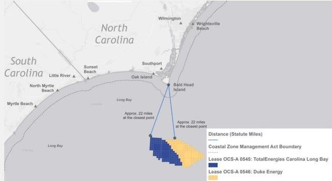 With an eye out for whales, survey work starts on offshore wind farms south of Wilmington
Researchers are collecting data for the best place to moor buoys that will measure wind speeds and monitor environmental conditions, including the presence of marine life
There are still plenty of hurdles to overcome, including lots of federal and state regulatory approvals, making sure the projects are economically viable, and securing customers for the power the giant turbines will produce. But a pair of offshore wind farms proposed about 22 miles south of Bald Head Island took a major step forward this month with the first survey work for the projects. Sailing from Southport, a research vessel owned by Geodynamics spent recent days mapping the seafloor to help identify the best locations for the placement of scientific buoys. The surveys will be used to find mooring areas for three buoys that will be the least environmentally intrusive while also allowing the collection of data to help direct the subsequent development of the offshore turbines that will rise more than 500 feet from the ocean’s surface. The buoys also will be equipped with sensors to detect marine life, including birds. TotalEnergies Renewables USA and Cinergy Corp., a non-regulated subsidiary of Duke Energy, spent a combined $315 million to lease nearly 140 miles of ocean from the federal government for the pair of huge wind farms. Once fully up and running, probably in the early 2030s, the wind farms could produce enough power to supply 750,000 homes. With the two wind farms adjacent to each other, the companies have decided to work together to help limit costs and take advantage of economies of scale. But first the companies have to determine where to place the giant windmills. “This is just initial information data gathering,” said Elizabeth Bennett, spokesperson for TotalEnergies, adding that the buoys will likely be deployed next year. “And while these projects are still in their very early stages, we see this as an opportunity for the Carolinas to take advantage of the millions of dollars in investments these projects can bring.”
Watching out for whales
Offshore wind is seen by clean energy advocates as a key component in helping governments de-carbonize their energy grids by reducing their reliance on dirty, greenhouse gas-spewing power sources like coal and natural gas. That includes North Carolina, which has a stated goal of reducing its 2005 level of carbon emissions by 70% by 2030. Offshore wind farms, however, have their critics. The projects are very capital intensive to build, although those costs drop dramatically once the turbines are up and running. Some coastal residents are also concerned that the giant windmills will damage their ocean “viewscapes,” and local officials fear the visual pollution also could harm the region’s vital tourism industry. Industry officials say the giant wind turbines will be next to invisible on the horizon. But perhaps the biggest concerns surround the wind farms potential impact on marine life, particularly the highly endangered North Atlantic right whale that migrates through North Carolina’s near-shore waters. A recent report by the National Oceanic and Atmospheric Administration (NOAA) estimated only 338 whales remain, a decrease from the 2021 estimate of 368 individuals. Ship strikes and entanglements with fishing gear are the top dangers for the highly endangered animals. Bennett said to help limit interactions with marine life the R/V Shackelford, the survey vessel, had a dedicated observer on board. It also voluntarily operated at a maximum speed of 10 knots to allow maximum time for proactive measures if a whale or other marine mammal was spotted. In addition, no equipment was used during the survey work that had sound frequencies harmful to marine life. The Natural Resources Defense Council (NRDC) has praised the companies for the protective measures they’ve put into place to limit interactions with the right whales.
Balancing cost with economic benefits
The pair of wind farms planned for Long Bay south of Brunswick County will join another offshore wind farm planned for roughly 27 miles off Kitty Hawk on the Outer Banks. While North Carolina has space and the wind resources for more offshore facilities, that idea appears cloudy right now. The U.S. Bureau of Ocean Energy Management (BOEM) this month rejected proposals for two new wind farm sites off the Outer Banks due to concerns raised by the Pentagon that the wind farms could interfere with military aviation training. Governor Roy Cooper, a big proponent of renewable energy, called the decision “extremely disappointing.” In 2021, Cooper signed an executive order that doubled down on the state’s commitment to offshore wind power, with goals of 2.8 gigawatts (GW) off the North Carolina coast by 2030 and 8 GW by 2040 − enough to power roughly 2.3 million homes. But a bigger speed bump to more offshore wind could be the state’s carbon-reduction plan, a roadmap on how the state’s will reach its aggressive goals to reduce emissions and reach a carbon-neutral energy sector by 2050. Although the plan has to be approved by the N.C. Utilities Commission, it is Duke Energy that largely lays out the way forward as the largest utility in the state. In the latest version of its plan, which is reviewed every two years, the utility’s favored proposal retains an option for adding up to 1.6 GW of offshore wind by 2035. Katharine Kollins, president of the Southeastern Wind Coalition, a nonprofit that advocates for wind energy development in the Southeastern U.S., thinks the company should be looking to do more. “It made a case for offshore wind, but not as strongly as we’d like to see,” she said of Duke’s plan. While offshore wind’s upfront capital costs can be substantial, Kollins said so are the potential economic development benefits for North Carolina of tapping into a largely undeveloped business sector that holds huge potential to grow as more and more states turn to offshore wind to meet their carbon-reduction goals. Without taking into account those economic benefits, you only have the carbon-reduction benefits from a power sector that’s still immature and expensive when compared to solar and other renewables and will likely stay that way for years to come. “Yes, there are significant capital expenses right now,” Kollins said. “But offshore wind comes with benefits that we’re not going to get with anything else.”
Read more » click here
Previously reported – September 2024
Why development of Brunswick County’s offshore wind farms has largely moved onshore
Duke Energy has included offshore wind in its latest plan to reduce carbon emissions. Now state regulators are reviewing the proposal
The wind hasn’t stopped blowing, and the waters just off the Brunswick County coast are as prime a spot for an offshore wind farm as they always have been. But after a flurry of announcements and activity in previous years, including offshore survey work last summer, things have been largely quiet on the ground and in the waters roughly 22 miles south of Bald Head Island. That’s not the case in Raleigh, though ’ and that’s largely where the future of the Brunswick wind farms will be decided. “Industry is waiting to hear if the N.C. Utilities Commission is going to green light offshore wind as part of the state’s electricity mix in the coming years,” said Katharine Kollins, president of the Southeastern Wind Coalition, a nonprofit that advocates for wind energy development in the Southeastern U.S. “It’s hard for them to consider spending huge sums of money on these projects if they don’t have some guarantees and cost certainty.”
Pros and cons
Offshore wind is seen by clean energy advocates as a key component in helping governments de-carbonize their energy grids by reducing their reliance on dirty, greenhouse gas-spewing power sources like coal and natural gas. That includes North Carolina, which has a stated goal of reducing its 2005 level of carbon emissions by 70% by 2030 − although Duke Energy would like to see that goal pushed back to 2035 − and becoming carbon-neutral by 2050. In 2022, TotalEnergies Renewables USA and a Duke Energy subsidiary paid the federal government a combined $315 million to lease nearly 140 miles of ocean off Brunswick County for a pair of huge wind farms. If fully developed, which would occur sometime in the early 2030s, the wind farms could produce enough power to supply 750,000 homes. The pair of wind farms proposed for Long Bay will join another offshore wind farm planned for waters roughly 27 miles off Kitty Hawk on the Outer Banks. That project is farther along than the Southeastern N.C. wind projects. While embraced by clean energy advocates, offshore wind farms have their critics. The projects are very capital intensive to build, although those costs drop dramatically once the turbines are up and running. Some coastal residents are also concerned that the giant windmills will damage their ocean “viewscapes,” although officials have said the Brunswick turbines will be next to invisible from the county’s south-facing beaches. Concerns also have been raised about the offshore turbines impacts on marine life, specifically marine mammals like the highly endangered North Atlantic right whale.
Offshore wind moves center stage
As the state’s largest utility, Duke is largely driving the train on what sort of mix of power production sources will be needed to meet the state’s carbon-reduction goals in the electricity sector while also keeping the lights on at an affordable price for consumers. In 2021, Cooper signed an executive order that doubled down on the state’s commitment to offshore wind power, with goals of 2.8 gigawatts (GW) off the North Carolina coast by 2030 and 8 GW by 2040 ’ enough to power roughly 2.3 million homes. But Duke’s initial Carolinas Resource Plan, basically a road map on how the utility proposed to reduce its future carbon emissions in both Carolinas, only had offshore wind as an option to meet future power needs. That changed in January, however, when the utility, citing a projected surge in future electricity demand, proposed moving forward with plans to add 2.4 GW of offshore wind to its grid in the 2030s as part of its updated carbon plan. That plan, which environmentalists and clean energy advocates are contesting as still being too reliant on old energy sources like natural gas plants instead of focusing on renewables like wind and solar, is now being reviewed by the utilities commission. Duke spokesperson Bill Norton said the utility has asked regulators to allow it to gather additional information to make sure integrating power produced by offshore wind farms into the company’s power grid is financially viable. That work would include pricing information, an issue that derailed several other proposed offshore wind projects after companies decided they couldn’t build and operate the wind farms at the contracted price utilities had agreed to buy the power at. “TotalEnergies looks forward to the (utilities commission) order in December 2024 and additional approvals from N.C. and S.C. as necessary, which will inform the next steps for development activities in 2025,” said company spokesperson Elizabeth Bennett in an email.
‘Moving in a positive direction’
Offshore wind projects, while certainly green, have run into some rough financial waters in recent years. That stormy weather included efforts by companies to renegotiate their contracts with utilities due to rising construction costs, higher inflation and supply chain disruptions, surging interest rates, and the war in Ukraine. Those headwinds culminated in some wind developers in New York and New England deciding to walk away from projects rather than get stuck in money-losing endeavors. But Kollins said the offshore wind sector is rebounding, with several large farms in the Northeast now sending power onshore and some of the financial and supply chain issues that plagued earlier projects getting ironed out as the industry matures in the U.S. “There are a lot of good things happening for offshore wind now,” she said. “Certainly, challenges for the industry remain, but I think it’s definitely moving in a positive direction.”
Read more » click here
Previously reported – October 2024
11 things to know about offshore wind farms in North Carolina and the United States
There are currently three offshore wind farms proposed for the N.C. coast, including two off Brunswick County.
After a few industry hiccups, the proverbial winds seems to be blowing back in the right direction for offshore wind projects that the Biden administration and many states, including North Carolina, are relying on to help them tackle carbon emissions from their power sectors.
Among the offshore wind projects on the drawing board are three wind farms off the coast of North Carolina, including a pair roughly 20 miles south of Bald Head Island in Brunswick County.
Here are 11 facts and tidbits to know about the Brunswick projects and offshore wind farms in general.
-
-
- In 2022,TotalEnergies Renewables USA and a Duke Energy subsidiary paid the federal government a combined $315 million to lease nearly 140 miles of ocean off Brunswick County for a pair of huge wind farms. The projects are currently in the very early stages of planning and survey work.
- If the Brunswick wind farms are fully developed, which would occur sometime in the early 2030s, the projects could produce nearly 2.4 GW of power, enough to supply 750,000 homes.
- In 2021, Gov. Roy Cooper signed an executive order that doubled down on the state’s commitment to offshore wind power, with goals of 2.8 GW off the N.C. coast by 2030 and 8 GW by 2040 ’ enough to power roughly 2.3 million homes.
- The latest version of Duke Energy’s Carolinas Resource Plans, which includes carbon-reduction proposals for both North and South Carolina, includes plans to add 2.4 GW of offshore wind to its grid by 2035. The N.C. Utilities Commission is currently reviewing Duke’s proposed plan, with a decision expected by the end of the year.
- According to the National Renewable Energy Lab (NREL), Virginia, North Carolina, South Carolina, and Georgia have 82% of the East Coast offshore wind resource in shallow water and 45% of the total East Coast offshore wind resource.
- Currently the largest offshore wind farm under construction in the U.S. is being built by Dominion Energy 27 miles off the coast of Virginia. The project, which should be finished in about two years, is expected to generate 2.6 GW from 176 turbines.
- Offshore wind turbines are getting taller and taller. According to the U.S. Department of Energy, the average height of the hub − where the large, spinning blades are attached to the monopole ’ was about 330 feet in 2016. That is expected to increase to 500 feet, the height of the Washington Monument, by 2035. Add the height of the blades at their apex, and that increases to more than 800 feet.
- North Carolina is eager to capitalize on the economic opportunities offered by the growing offshore wind market. Efforts include the formation of the N.C. Taskforce for Offshore Wind Economic Resource Strategies (NC TOWERS).
- A 12-turbine wind farm off the Hamptons on New York’s Long Island became the first U.S. offshore wind project to provide power onshore when it was connected to the grid in December 2023.
- Despite significant federal incentives and strong political support, offshore wind has had a rough few years. Issues that have arisen include post-pandemic inflation spikes, rising interest rates, supply chain bottlenecks, and worries from coastal residents that huge turbines would ruin their “viewscapes.” Some Republicans and environmentalists also have raised concerns about the wind farms’ impacts on marine life, particularly whales.
- Compared to other countries around the world, the U.S. is a laggard in harnessing the energy potential of offshore winds. The top five countries, in descending order, generating electricity from offshore wind farms are China, the United Kingdom, Germany, the Netherlands, and Denmark.
Read more » click here
Previously reported – November 2024
Update provided on offshore wind off Brunswick County coast
During the Oct. 23 Brunswick County Shoreline Protection Consortium meeting, representatives from one of the offshore wind lease holders for the Carolina Long Bay Wind Energy Area, located off the Brunswick County coast, provided an update on the project, while local officials and stakeholders pushed back on the plans. TotalEnergies, a French multinational energy and petroleum company, and Cinergy Corporation, a direct non-regulated Duke Energy subsidiary, won the May 2022 auction for lease of the 86 square nautical mile Carolina Long Bay Wind Energy Area (WEA), with TotalEnergies leasing 54,937 acres and Cinergy Corporation leasing 55,154 acres. If developed, the WEA could generate at least 1.3 gigawatts of offshore wind energy, enough to power nearly 500,000 homes. The Carolina Long Bay area encompasses much of the Brunswick County coast and extends into South Carolina past Myrtle Beach. The wind turbines will be located at least 22 miles from Bald Head Island’s shores and eight miles west of Frying Pan Tower, representatives confirmed during last month’s meeting. The turbines would be less visible as one moves further south down the county’s coast. The Brunswick County Board of Commissioners in 2021 adopted a resolution opposing offshore wind turbines sited fewer than 24 nautical miles from the shoreline. Several Brunswick County municipalities have adopted similar resolutions. During the Oct. 23 meeting, Representative Frank Iler asked if the turbines would be visible from shore. In response, Susan Munroe, TotalEnergies community engagement manager, said the turbines would be “minimally visible.” “The closer we get to development, we’re going to do some visualizations,” she said. “It’s going to be minimally visible depending on the time of day, depending on where you are.” Albie Solana, TotalEnergies’ fisheries liaison, noted the moisture in the air during the summertime in Brunswick County will further reduce visibility. Regarding a timeline for development and construction of offshore wind turbines there is still a “long, long, long way to go,” according to Munroe. Munroe explained that the North Carolina Utilities Commission (NCUC) will release its next order of the state’s carbon plan, originally adopted in 2022. The plan is a result of the ratification of House Bill 951 in 2021, which requires the NC Utilities Commission (NCUC) to take “all reasonable steps” to achieve 70% carbon emissions reductions from 2005 levels by 2030 and achieve carbon neutrality by 2050. “The [NC] Utilities Commission will release their next order of the carbon plan December of 2024,” she said, “and for us, for the project what that means is that they will provide some sort of direction.” Although TotalEnegeries or Duke Energy are not currently privy to what the updated order will call for, Munroe said the next major action on the Carolina Long Bay project would be installation of data collection buoys in the lease area. The Carolina Long Bay WEA was surveyed in 2023 to find “suitable” locations for the deployment of three data-collection buoys, The Brunswick Beacon reported. If approval for the buoys is granted, two will be used to collect meteorological data and one will be used to collect environmental data, namely for wildlife monitoring. Data will be collected over a one- to two-year period. Following the TotalEnergies presentation, local leaders pushed back on the plans for offshore wind development off the county’s coast, asking about the benefits the project will bring to Brunswick County, the municipalities and citizens versus the impacts. Brunswick County Commissioner Marty Cooke said the Carolina Lay Bay project is “being forced down our throats” by the Bureau of Ocean Energy Management (BOEM), North Carolina Governor Roy Cooper and the former Obama Administration, noting the county is not in favor of offshore wind development off its shores. “We don’t want these things anywhere near us, and if you’re going to have a 300-foot tall tower out there that’s 22 miles out or whatever, we’re going to see them,” Cooke said. Oak Island Mayor Elizabeth White pressed TotalEnergies representatives on how towns and citizens within the turbines’ viewshed will benefit from the project. “The benefits, I’m not hearing them being articulated – it’s all very vague at this point. … It’s hard to support something when we don’t know what it is we’re supporting other than visually offshore, but I can’t go back to my community and as the mayor say, ‘This is how our community will benefit from this project.’ We’ll pay the price for years,” White said. North Carolina For-Hire Captain Association Officer Cane Faircloth echoed Cooke’s sentiment, noting the organization, based on its independent research, feels the offshore wind industry is not being truthful and transparent about the effects of offshore wind projects. Munroe, in response to these comments, said they hear the various concerns “loud and clear” and will work to address them as the project moves forward. “We are so early in the process and I’m grateful for that,” she said. “We have a lot to learn. We have a lot of time to listen to concerns and learn.”
Read more » click here
Previously reported – January 2025
Ports, suppliers in 40 states are invested in offshore wind
The nation’s burgeoning offshore wind energy industry has created thousands of jobs, boosted work in shipyards and ports, and includes a supply chain that spans 40 states, according to a new report. Billions of dollars have been invested in things like new and retrofitted vessels for offshore wind developers, ports infrastructure, and the expansion of renewable energy manufacturing facilities that support offshore wind, according to Oceantic Network, a Baltimore-based nonprofit that advocates growing the country’s offshore renewable energy industry and supply chain. According to the report, “Offshore Energy at Work,” 25 U.S. ports are either taking part in the industry or preparing to support it. Last February, North Carolina State Ports Authority Executive Director Brian Clark signed a record of decision on a proposed plan to create a multi-use terminal that would support manufacturing and operations for offshore wind and automotive industries at the Morehead City port. The proposed project entails developing land the port owns on Radio Island. It includes construction of a 300,000-square-foot manufacturing facility with office space for offshore wind, a roughly 60-acre gravel pad for storage, a new rail spur that would tie into the existing rail, roadway improvements, and the installation of a gas line from Morehead City to the island. The estimated price tag is $250 million to $285 million. “We have no updates to provide at this time,” Elly Cosgrove, N.C. Ports senior communications manager, said in an email Wednesday. “The Record of Decision signed in February is the latest as it pertains to Radio Island.” It is unclear how an executive order President Donald Trump signed in his first day back in the White House pumping the brakes on new offshore wind development might affect the ports’ proposed plans, including four lease areas off the North Carolina coast. Five days after Oceantic Network released its 60-page report, Trump suspended new leases on the entire outer continental shelf. The order will stand until it is revoked. The order also blocks the federal government from issuing new federal permits to offshore and onshore wind projects, including four lease areas off the North Carolina coast, until the secretary of Interior conducts a “comprehensive assessment and review” of the permitting process. Oceantic Network joined other renewable energy proponents in immediately rebuking the president’s order, calling the permitting pause “a blow to the American offshore wind industry.” Trump’s actions threaten thousands of American offshore wind industry-related jobs in shipyards, factories, and ports, and “strand businesses who have reorganized their operations to support the sector,” Oceantic said in a release. “While under a National Energy Emergency created by an unprecedented rise in energy demand, we should be working to quickly bring generation online instead of curtailing a power source capable of providing base load generation and creating new jobs across 40 states,” Oceantic founder and CEO Liz Burdock said in the release. “We urge the administration to reverse this sweeping action and keep America working in offshore energy as part of its commitment to an ‘all-of-the-above’ energy strategy.” A spokesperson for Oceantic Network declined to comment further. In a statement it released following Trump’s order, the Southeastern Wind Coalition called offshore wind “an economic force” in the U.S., investing billions of dollars in reviving previously underutilized ports and creating training programs for the work sector. “Wind energy is critical to achieving American energy dominance, meeting our growing electricity demand, and creating stable manufacturing jobs across the nation,” Southeastern Wind Coalition President Katharine Kollins said in a release. “Wind energy is a vital part of the global electricity system, and ceding the advancement and development of wind technologies to other nations will only set us back.” More than 100 companies in the Southeast produce components for the industry, according to the wind coalition. But at least one of those has turned to the European market to stay afloat. An official with Nexans, a France-based power and communications cable producer, said in an article published earlier this month that the company’s Charleston, South Carolina, plant – the largest subsea cable manufacturer in the U.S. – is shipping its product to Europe. Nexans vice president for generation and transmission told renewable energy publication Recharge that high demand for cables in Europe is “a blessing in disguise” for the plant. Still, all is not all doom-and-gloom for the industry. In an email announcing the dates and location for the International Partnering Forum, the largest offshore wind energy conference in the U.S., Burdock noted that five commercial-scale, federally approved offshore projects are either under or near construction. Another six projects have received federal approvals. “Despite misleading headlines, there is no question that the industry is moving forward,” Burdock wrote.
Read more » click here
Previously reported – February 2025
As NC wind energy projects advance, uncertainty rules
Wind projects that are leased, permitted or under construction in or near North Carolina are likely to survive buffeting by renewed wind energy skepticism from the Trump administration. Shortly after taking office in January, President Donald Trump issued an executive order barring new offshore wind leases and requiring reviews of existing and permitted wind projects. Although it was not targeting existing leases, industry supporters have questions about what rules, permits or projects it could impact and the potential for broader impacts through the workforce and manufacturing industries. “It’s not that companies are moving on as business as usual, but there’s so much uncertainty that they can’t just come to a screeching halt, and then all of this could change in five minutes,” Karly Lohan, Southeastern Wind Coalition’s senior Carolinas program manager, recently said in an interview with Coastal Review. “They have to keep going and figure this out as they go. And realistically, we’re probably not going to know an answer to a lot of those questions, and the true implications of this offshore wind executive action until … we know.” Lohan noted that the nonprofit coalition she represents is focused on educational outreach about wind energy and does not speak or act as a trade organization for the industry. A wind project off Kitty Hawk along the Outer Banks that’s owned by Avangrid Renewables and Dominion Energy is not yet under construction, but it still has active leases. Dominion Energy’s $9.8 billion Coastal Virginia Offshore Wind, or CVOW, project off Virginia Beach is going full speed ahead. The 2.6-gigawatt project is currently about half done and is expected to be completed on schedule by the end of 2026, according to company spokesman Jeremy Slayton. Duke Energy, along with Total Energies, has leased an offshore area off Southport for a wind farm known as Carolina Long Bay project, but it is in very early permitting stages. “We are still easily at least six or seven years away from construction for any of those projects,” Lohan said. The two land-based wind energy projects in North Carolina – Amazon Wind U.S. East in Elizabeth City, completed in 2017, and Timbermill Wind in Chowan County, completed in 2024 – will not be affected by the orders, Lohan said. Duke Energy has expressed interest in future land-based projects in North Carolina, but no information has been released about potential locations or plans, she said. While Dominion is working to complete its Virginia Beach project, it is keeping its CVOW-South, formerly the Kitty Hawk North project, on hold for the time being, Slayton, the company’s spokesman, said. “CVOW-South provides us with a potential option for additional offshore wind development,” he said in an email. “Our most recent long-term planning document, the Integrated Resource Plan, forecasts this project, if we pursue it, for the mid-2030s. At this time, we do not have a firm timeline or cost for developing this lease area.” Dominion Energy came to an agreement in July 2024 to purchase one-third of the Kitty Hawk North project, which is about 27 miles east of Corolla, the northern end of the Outer Banks, and about 38 miles southeast of the Sandbridge community in Virginia Beach. “Avangrid was willing to sell a portion of the project at a reasonable cost,” Slayton told Coastal Review at the time. “And we believe it was prudent to take advantage of this opportunity to meet the growing needs of our customers with clean energy and also help us achieve the requirements of the Virginia clean Economy Act, which calls for up to 5.2 gigawatts of offshore wind.” If developed, the project will connect to the grid for CVOW-South at a new substation at Corporate Landing in Virginia Beach, near Naval Air Station Oceana, he said. Katharine Kollins, president of Southeastern Wind Coalition, a nonprofit advocacy group, said that wind power production in the U.S. is behind the mature development of both offshore and onshore wind in Europe, but it has the capacity and resources to build a robust wind energy industry. “It requires economies of scale in manufacturing, all of the components it requires, economies of scale in construction and development and even in operations and maintenance,” she told Coastal Review recently. “And so, what the manufacturers have been saying to advocates in the industry for years is, ‘We need a solid pipeline of projects before we can commit a billion dollars to building a manufacturing facility in the U.S. that can then produce the major components, or an offshore wind turbine that would include your towers, your blades.’ Right now, I think the only thing that we can manufacture in the U.S. is foundations.” Like any energy production, wind energy is an equation of risk versus benefits, she said. And wind is economical, clean and safe, she added. “You don’t hear anything about wind spills,” she said. Yes, there are bird mortalities associated with strikes, but far, far less than the estimated one billion annual deaths from birds striking buildings. Kollins said the problem is uncertainty. “You know, uncertainty is not good for investment, and so if you have some significant political uncertainty, which makes it really hard for investors to move forward with any of those components that I was mentioning, whether in components, referencing manufacturing, referencing development, even thinking about leases. “Like, am I going to go pay $100 million to lease a square of ocean that, then I might have another presidential administration that says, ‘I don’t really like this?’ No thanks,” she said. “It does make it hard to overcome. This is an industry that should be nonpartisan.”
Read more » click here
Previously reported – February 2025
Trump’s decision to pause offshore wind farms creates stormy waters for NC projects
The president’s move has brought into question the political and financial viability of future offshore wind farms, including two large projects for near-shore waters off Brunswick County
They are expensive to build, just finding their footing on this side of the Atlantic and have faced backlash from parties as varied as beachfront property owners and fishermen to coastal businesses and fossil fuel backers.But the U.S.’s still-young offshore wind industry has recently run into its biggest challenge of all, and one that could seriously destabilize the entire industry − including here in North Carolina: President Donald Trump.“I’d say it’s in critical condition,” said Dr. Brian Murray, director of the Nicholas Institute for Energy, Environment and Sustainability at Duke University. Trump’s move announced on his first day in office to cancel all future leases for offshore wind farms and block the federal government from issuing new permits for existing projects has effectively taken the wind out of the sails of several projects that were in the exploratory and planning stages, including two off Brunswick County and one off Kitty Hawk on the Outer Banks. The president also has asked federal officials to see if they could claw back any permits issued for existing projects. Trump’s executive order doesn’t stop the handful of offshore wind projects, primarily in the Northeast, that are already under construction from moving forward. But because building offshore wind farms is incredibly capital intensive, which much of that money coming at the front-end of the massive projects, stopping any additional offshore wind projects severely limits companies and utilities from taking advantage of economies of scale. Murray said the president also has hinted that he could seek to end the tax credits for renewable energy projects included in President Joe Biden’s Inflation Reduction Act, which was one of the big financial incentives that made many of these billion-dollar wind projects financially attractive in the first place. “Now there’s a big question if those tax credits will even materialize,” he said. Katharine Kollins, president of the Southeastern Wind Coalition, a nonprofit that advocates for wind energy development in the Southeastern U.S., said all of this political and financial uncertainty has left the industry largely in limbo and wondering what the future of offshore wind is in the U.S.
Ceding another industry to China?
Trump said he was taking the step to all-but end future offshore wind farms, which he railed against during his campaign, because the U.S. is facing an “energy emergency.” But to clean energy supporters and environmentalists, the president’s actions don’t add up. “To most folks in the energy industry, you don’t declare an energy emergency and then ensure your country can’t access one of the largest and easiest ways to generate electricity,” Kollins said, noting that it also up ends the “all of the above” approach to having a diverse mix of energy sources in your power portfolio. Ending federal support for offshore wind could also cede another renewable energy business sector that most economists believe will offer huge growth opportunities in the coming decades as fossil fuels run out and become more politically unpalatable to foreign countries, particularly China. Already, the West has all but given up in competing in the solar panel market, with China dominating the industry, and the Chinese are making great leaps and strides in dominating the electric vehicle market as American and European automobile manufacturers dither. That’s not to say the offshore wind industry doesn’t already have a sizeable economic footprint in the U.S. According to the Oceantic Network, which promotes the offshore renewable energy industry and associated supply chain, there’s a $25 billion supply chain in 40 states and at more than two dozen ports that supports the industry. One business that has been looking to get into the wind field is the N.C. State Ports Authority, which last year floated a plan to build a multi-use terminal that would support the state’s offshore wind and automotive industries at its Morehead City port. “These initial actions by the president have been incredibly harmful for the industry,” she said.
‘Delays cause more problems’
With federal support for renewable energy sources looking shaky at best, it isn’t known what that might mean for states and had planned on integrating lots of offshore wind into their future energy grids as a way of increasing their clean energy footprint and reducing their greenhouse gas emissions, which is the primary driver of climate change. According to Oceantic, as of the start of 2025 there are six offshore wind projects in operation or under construction delivering 5 megawatts of power to the nation’s grid, with state demand for another 116 megawatts to meet future power demands and clean energy mandates. In North Carolina, the latest iteration of the Carolinas Resources Plan approved last fall by the N.C. Utilities Commission calls for including up to 2,400 megawatts of offshore wind in Duke Energy’s portfolio by 2035 if a study due later this year shows it is feasible to move forward.Two of North Carolina’s major wind projects are planned for the waters just south of Brunswick County, with initial development and evaluation of the projects ’ including potential impacts to marine life like the high endangered North Atlantic right whale ’ already started. One of the Brunswick sites is leased to one of Duke’s unregulated affiliates, while the other is leased to France’s TotalEnergies. “We are continuing to evaluate all the Presidential Executive Orders that came out in January, including the executive order on offshore wind,” said Duke spokesperson Bill Norton. “We look forward to working with the new administration on constructive outcomes to ensure reliable and affordable energy for our growing customer base.” Kollins said the industry already was facing some headwinds because of inflationary pressures and the need to rework or cancel existing contracts with utilities that didn’t make the offshore projects financially viable. Now with Trump’s actions, some companies are abandoning projects or completely exiting the U.S. market. That, in turn, leaves businesses that support the industry with fewer potential customers and projects and wondering if they’ll be able to weather the storm until the political winds hopefully change in a couple years. “There’s a negative feedback loop with the supply chain, unfortunately,” Kollins said. Duke’s Murray said the political and regulatory uncertainties have put a big chill on the offshore wind industry. “It was already a challenging industry in many respects,” he said. “But what’s happened now will cause delays, and delays cause more problems.”
Read more » click here
Previously reported – August 2025
Have politics and changing energy policies sunk Brunswick’s proposed offshore wind farms?
A move away from clean energy in Washington and Raleigh could make it more difficult for N.C.’s large, expensive offshore wind projects to get built.
Call it a state of suspended animation. A mix of politics, changing national energy priorities, a lack of regulatory direction, and industry nervousness has all but frozen progress on a handful of wind farms that were under development off the North Carolina coast, including two roughly 20 miles south of the Brunswick County shoreline. But does that mean the state, and the U.S. as a whole, is out of the offshore wind game even as they continue to increasingly sprout in waters around Europe, China and South Asia? Not necessarily, experts say. But until there’s more political support for the renewable energy source, they admit it’s going to be hard to convince companies to make the massive investments it takes to get the still-nascent industry in the U.S. really up and running.
What’s planned for Brunswick County?
In 2022, TotalEnergies Renewables USA and a Duke Energy subsidiary paid the federal government a combined $315 million to lease nearly 140 miles of ocean off Brunswick County for a pair of huge wind farms. If fully developed, which would occur sometime in the early 2030s, the wind farms could produce enough power to supply 750,000 homes. The pair of wind farms proposed for Long Bay will join another offshore wind farm, now also split into two parts, planned for waters roughly 27 miles off Kitty Hawk on the Outer Banks. That project is farther along than the Southeastern N.C. wind projects.
Why look to offshore wind for power?
Offshore wind is seen by clean energy advocates as a key component in helping governments de-carbonize their energy grids by reducing their reliance on dirty, greenhouse gas-spewing power sources like coal and natural gas. While embraced by clean energy advocates, offshore wind farms have their critics − including notably President Donald Trump. The projects also are very capital intensive to build, although those costs drop dramatically once the turbines are up and running. Some coastal residents are also worried that the giant windmills will damage their ocean “viewscapes,” although officials have said the Brunswick turbines will be next to invisible from the county’s south-facing beaches.
What is the situation today?
When many of the offshore wind farms for the East Coast were proposed, President Joe Biden was in office and pushing green energy as a way to fight climate change was a government priority. To help jump start the industry, the Biden administration simplified and speeded up the permit process and, crucially, provided tax breaks and other incentives for the projects, notably in the massive 2022 Inflation Reduction Act. Trump has all but ended those perks for offshore wind, although a handful of projects mostly in the Northeast are still moving forward. His administration also has slow-walked issuing new permits for projects and, in some cases, begun a review of previously approved offshore wind farms to see if they were adequately vetted. But the biggest hit occurred recently with Congress approving Trump’s “One Big Beautiful Bill” that removed almost all of the federal financial incentives for renewable energy like wind and solar in favor of giving breaks to more traditional, fossil fuel-driven sources like oil, coal and natural gas.
State mandates and goals
While federal support for offshore wind projects has all but evaporated over the past six months, many states have goals of incorporating more and more energy from renewable sources into their power sectors to help reduce their greenhouse gas emissions. That includes North Carolina, where carbon emissions from the power sector are the state’s second largest source of heat-trapping gasses after transportation. Current state law requires the state’s utilities, which largely means Duke Energy, to reduce its 2005 level of carbon emissions by 70% by 2030 − although that goal has been pushed back to 2035 − and become carbon-neutral by 2050. Duke has proposed to meet those goals by incorporating solar, land and offshore-based wind farms, more nuclear and maybe even hydrogen into its future energy grid as it retires its older, dirty coal-fired power plants. The latest version of the company’s carbon plan calls for including up to 2,400 megawatts (MW) of offshore wind in its energy portfolio by 2035. But Senate Bill 266 in Raleigh that has passed the Republican-run General Assembly, but been vetoed by Gov. Josh Stein, a Democrat, would eliminate the 2030-35 interim carbon reduction goal while keeping in place the longer-term goal of being carbon neutral by 2050. Legislators are likely to consider overriding the governor’s veto when they reconvene later this summer. Supporters say the bill will save customers money by keeping utility bills from rising too quickly and offer Duke flexibility in meeting rising electricity demand from a growing population and power-hungry businesses, like data centers. But environmentalists and clean energy advocates say the move, which mirrors some of the climate change rollbacks implemented by the Trump administration, would be short-sighted and slow down the state’s transition to sources of clean energy − especially capital-intensive projects like offshore wind farms. “You really need that interim carbon target to make sure we are taking steps now to put as many renewables on the grid as possible in the short term, otherwise we won’t see any real movement until decades from now, and by then it’s going to be too late,” said Katharine Kollins, president of the Southeastern Wind Coalition, a nonprofit that advocates for wind energy development in the Southeastern U.S.
Future of the Brunswick offshore wind farms
With the projects still young in the development stage, not a lot has changed. Among the work that is going on is a Duke-led study, due this summer, into the financial feasibility of offshore wind ordered by the N.C. Utilities Commission. “We still have a long-term horizon before we see any steel in the water,” Collins said. That gives plenty of time for maybe a change of focus in Washington and Raleigh back toward a more green energy friendly view − or even moves to show continued support for the green energy path the states have been on. But even the most optimistic clean energy supporters know the clock is ticking. “There is a lot states can do even with federal permitting and financial support paused,” Kollins said. “It really is in the hands of the states right now as to where things go and if we do move forward, especially in North Carolina.”
Read more » click here
Duke Energy scraps wind projects off NC coast, including Brunswick County. Here’s why.
The decision is another blow to the state’s nascent offshore wind sector that has been facing serious economic and political headwinds in Washington and Raleigh recently
In a move sure to draw blowback from clean energy advocates, Duke Energy says it won’t pursue any wind farms off the N.C. coast − including two wind-to-energy areas just south of Brunswick County − in the coming years. The move was driven by financial considerations, the utility giant said this week. “The (acquisition request for information) process determined that offshore wind is not cost-competitive at this time, so no RFP will be issued – this decision is supported by the independent evaluator that oversaw the proceedings,” said Duke spokesperson Bill Norton. “Nonetheless, the evaluation process provided valuable project, cost and schedule data that will inform long-term planning assumptions for the Carolinas Resource Plan being filed later this year.” Offshore wind, along with solar, was seen by environmentalists and others as a key component of an ambitious plan by North Carolina officials to significantly reduce the state’s carbon footprint from the Tar Heel State’s energy sector, the second largest polluter of greenhouse gasses that fuel climate change after transportation. But since legislation hashed out by then-Gov. Roy Cooper, GOP legislative leaders and Duke in 2021 set goals of substantially reducing carbon emissions by 2030 and the state reaching carbon-neutral by 2050, the law has been steadily chipped away at by economic factors and changing political winds. First, the N.C. Utilities Commission agreed with Duke and others that the 2030 goal was unrealistic and should be pushed back to at least 2035. Second, a bill passed this summer over the veto of Gov. Josh Stein drops the interim carbon-reduction goal, but maintains the 2050 target, due to concerns over rising power bills and the reliability of some renewable energy sources under certain conditions. And finally, President Donald Trump has not hidden his disdain for renewable energy sources − and offshore wind in general. That has sent the sector into financial limbo as permitting for projects has been halted or placed under additional review and financing for the projects, which require a lot of upfront capital, has become increasingly hard to secure.
‘Not cost effective’
The decision announced this week by Duke to scrap any immediate plans for offshore wind comes out of an update last year to the Carolinas Resource Plan, commonly known as the carbon plan, which called for a review of the financial feasibility of possibly developing up to 2,400 megawatts of N.C. offshore wind power on one or more of three sites approved by the federal government. Two of those areas are about 20 miles south of Brunswick County and the other is roughly 27 miles off Kitty Hawk on the Outer Banks. The independent evaluator’s review, approved by the N.C. Utilities Commission, started in January and was filed with the commission Aug. 11. The report included several different financial scenarios, involving confidential pricing details, submitted by the three owners of the lease areas − Cingery, a nonregulated subsidiary of Duke Energy, and TotalEnergies off Brunswick County and Avangrid off Kitty Hawk. “Because all submissions exceeded the reference price, the companies determined through the (action request for information) that offshore wind generation is not cost effective relative to other available resources at this time such that undertaking a binding RFP to procure offshore wind would not be a reasonable step toward executing the least cost (combined carbon plan and integrated resource plan),” states the filing.
So, is this the end of offshore wind in N.C.?
While obviously not a good sign for supporters of clean energy, this week’s announcement isn’t likely the end of offshore wind as a potential power source for North Carolina’s future power grid. While Duke officials said no further action will be taken on pursuing offshore wind in the near term, the information gathered through the economic report and other actions will be incorporated into future reviews of the carbon plan and help inform long-term planning considerations. The next proposed update to the carbon plan is to be submitted by Duke to the utilities commission in October. The alure of renewables as a way of building a greener power grid also isn’t going away, especially as economies of scale mean the cost of building wind and solar projects will continue to drop in the future and the impacts of climate change − from warmer summers and more intense rain events to stronger hurricanes and increased sea-level rise − continue to impact more and more parts of the globe. How Duke will replace the power generation that could have been produced by the offshore wind farms, whether through more natural gas plants or relying on emerging technologies like hydrogen or small modular nuclear reactors, also is a question that needs to be answered. But at least in the short term, it doesn’t look like offshore wind will be part of the answer to North Carolina’s future power needs.
Read more » click here
Previously reported – January 2026
Trump Halts 5 Wind Farms Off the East Coast
The Interior Department said the projects posed national security risks, without providing details. The decision imperils billions of dollars of investments.
The Trump administration on Monday said it would pause leases for five wind farms under construction off the east coast, essentially gutting the country’s nascent offshore wind industry in a sharp escalation of President Trump’s crusade against the renewable energy source. The decision injected uncertainty into $25 billion worth of projects that were expected to power more than 2.5 million homes and businesses across the Eastern United States, according to Turn Forward, an offshore wind advocacy group. The five wind farms were projected together to create together about 10,000 jobs. The move left intact just two operational wind farms in U.S. coastal waters — one small project off Rhode Island that began running in 2016 and a larger project off New York that has been fully operational since 2023. The five wind farms targeted on Monday had obtained leases from the Biden administration. Citing unspecified national security concerns, the Trump administration said it would freeze those leases, effectively blocking construction or operations and jeopardizing billions of dollars that had already been invested. One project, Vineyard Wind 1 off Massachusetts, is already partly running, with about half of the project’s 62 turbines sending power to the electric grid. In announcing the pause, Doug Burgum, the secretary of the interior, said in a statement that “the prime duty of the United States government is to protect the American people.” He said the decision addressed emerging national security risks as well as “vulnerabilities created by large-scale offshore wind projects with proximity near our East Coast population centers.” In a letter to the wind farm developers, Matthew Giacona, the acting director of the Bureau of Ocean Energy Management, declined to explain the national security concern but wrote that the danger posed by the projects could be averted only by suspending them. Mr. Trump has repeatedly called offshore wind turbines ugly, costly and inefficient. He has disparaged the clean energy source ever since, 14 years ago, he failed to stop an offshore wind farm visible from of one of his golf courses in Scotland. In addition to Vineyard Wind 1, other projects affected by the pause are Coastal Virginia Offshore Wind off Virginia, Sunrise Wind and Empire Wind off New York, and Revolution Wind off Rhode Island and Connecticut. The abrupt announcement left the wind farm builders sputtering. David Schoetz, a spokesman for Equinor, the developer of Empire Wind, said the company was reviewing the stop-work order and seeking more information from the government. Jeremy Slayton, a spokesman for Dominion Energy, which is building the Coastal Virginia Offshore Wind project, called it “essential for American national security and meeting Virginia’s dramatically growing energy needs.” Mr. Slayton argued that stopping the project for any length of time would threaten grid reliability “for some of the nation’s most important war fighting, A.I. and civilian assets.” He also dismissed the administration’s national security concerns, saying the wind farm was developed “in close coordination with the military.” The project’s two pilot turbines had been operating for five years without causing any impacts to national security, he said. “We stand ready to do what is necessary to get these vital electrons flowing as quickly as possible,” Mr. Slayton said. Orsted, the Danish energy giant that is building Sunrise Wind and Revolution Wind, said it was weighing its options, including discussions with the Trump administration “as well as the evaluation of legal proceedings.” The Interior Department said that the Pentagon had produced classified reports that found the wind farms posed national security risks and that an unclassified report from the Energy Department had found that wind farms could interfere with radar systems. Coastal Virginia Offshore Wind had escaped attention from the Trump administration for months, in part because of strong support from Gov. Glenn Youngkin, Republican of Virginia. But its fate became uncertain after Abigail Spanberger, a moderate Democrat, won the Virginia governor’s race in November to succeed Mr. Youngkin. In New York, Empire Wind has had an on-again, off-again relationship with the Trump administration. In April, the Interior Department ordered that construction on Empire Wind be stopped, pushing the $5 billion project to the brink of collapse. After several weeks and negotiations with Gov. Kathy Hochul, a Democrat, the administration allowed the project to proceed, at least until now. White House officials suggested they had relented only after Ms. Hochul agreed to approve new gas pipelines in the state, although the governor denied that any such deal had been made. New York’s lieutenant governor, Antonio Delgado, who is challenging Ms. Hochul in next year’s Democratic primary, said on social media on Monday: “Hochul got played. She sold out New Yorkers by fast tracking Trump’s fracked gas pipeline, thinking Trump would fund wind projects here in NY. There is no deal making with someone like Trump.” Representatives for Ms. Hochul did not respond to Mr. Delgado’s remarks. At a news conference on Monday, the governor lamented the impact of the pause. “Labor unions who very likely support the president are now having their holiday ruined because they’re now going to be losing their jobs,” she said. Mayor John Mitchell of New Bedford, Mass., a hub for the Vineyard Wind 1 project, said local officials were scrambling to understand the Trump administration’s order, but believed it could require “shutting down an operating power plant in the middle of the ocean.” The wind farm was expected to power nearly 200,000 homes this winter when its final turbines were connected. “It has the immediate effect, as far as we can tell, of throwing people who were working on our waterfront out of work three days before Christmas,” Mr. Mitchell said. The financial consequences for the companies behind the five offshore wind farms could be dire. When work on Empire Wind was initially paused in April, Equinor said it was losing $50 million a week. Delays to Revolution Wind were estimated to cost its developer, Orsted, approximately $15 million per week. In October, Orsted said it would cut about 2,000 jobs, or around 25 percent of its work force, over the next two years — a decision fueled by the Trump administration’s actions as well as tariffs, high inflation and interest rates. Offshore wind farms are generally expensive to build because they require specialized equipment and economies of scale are difficult to achieve. But at a moment when affordability has become a national concern, the five paused projects were largely expected to save consumers money on their electric bills, since many of the developers had locked in contracts with utilities to purchase the power at lower prices. At the same time, electricity demand is spiking, partly because of the growth of data centers, and power companies are struggling to keep up. “It is very hard to square this with the rising demand that so much of the government and industry is scrambling to address,” said Seth Kaplan, a vice president at Grid Strategies, a consulting firm. On the first day of his second presidential term, Mr. Trump issued an executive order halting all leasing of federal lands and waters for new wind farms. His administration has since gone after wind farms that had received permits from the Biden administration and were either under construction or about to start operation, using shifting explanations. The administration’s approach has suffered some legal setbacks. A federal judge this month struck down the halt on leasing mandated by the January order, saying it was “arbitrary and capricious” and violated federal law. Attorney General William Tong of Connecticut, a Democrat, said in a statement that the new order to pause Revolution Wind was “even more lawless and erratic” than the first. “We went to court over this before,” Mr. Tong said, noting that a court order was in place blocking the administration’s previous attempt to stop the wind farm. “Every day this project is stalled is another day of lost work, another day of unaffordable energy costs and other day burning fossil fuels when American-made clean energy is within reach,” he said. Executives in the offshore wind industry called the administration’s move on Monday harmful to the U.S. economy. “America’s offshore energy industry has put thousands of Americans to work in high-paying jobs in the construction of offshore projects that will effectively meet burgeoning demand for power throughout the Northeast,” said Erik Milito, the president of the National Ocean Industries Association, which represents offshore oil drilling firms and offshore wind developers. Cmdr. Kirk Lippold, who retired from the U.S. Navy in 2007, disputed the Trump administration’s claim that offshore wind projects threaten national security. He noted that all five projects halted on Monday had undergone rigorous reviews, including by the Defense Department. “Ironically, these projects will actually benefit our national security by diversifying America’s energy supplies, providing much-needed reliable power for the grid and helping our economy,” Mr. Lippold said.
Read more » click here
Trump administration suspends 5 wind projects off the East Coast, cites national security concerns
The Trump administration is suspending leases for five large-scale offshore wind projects under construction on the East Coast due to what it said were national security risks identified by the Pentagon
The Trump administration on Monday suspended leases for five large-scale offshore wind projects under construction along the East Coast due to what it said were national security risks identified by the Pentagon. The suspension, effective immediately, is the latest step by the administration to hobble offshore wind in its push against renewable energy sources. It comes two weeks after a federal judge struck down President Donald Trump’s executive order blocking wind energy projects, calling it unlawful. The administration said the pause will give the Interior Department, which oversees offshore wind, time to work with the Defense Department and other agencies to assess the possible ways to mitigate any security risks posed by the projects. The statement did not detail the national security risks. It called the move a pause but did not specify an end date. “The prime duty of the United States government is to protect the American people,” Interior Secretary Doug Burgum said in a statement. “Today’s action addresses emerging national security risks, including the rapid evolution of the relevant adversary technologies, and the vulnerabilities created by large-scale offshore wind projects with proximity near our east coast population centers.” Wind proponents slammed the move, saying it was another blow in an ongoing attack by the administration against clean energy. The administration’s decision to cite potential national security risks could complicate legal challenges to the move, although wind supporters say those arguments are overstated.
Projects paused over national security concerns
The administration said leases are paused for the Vineyard Wind project under construction in Massachusetts, Revolution Wind in Rhode Island and Connecticut, Coastal Virginia Offshore Wind, and two projects in New York: Sunrise Wind and Empire Wind. The Interior Department said unclassified reports from the U.S. government have long found that the movement of massive turbine blades and the highly reflective towers create radar interference called “clutter.” The clutter caused by offshore wind projects can obscure legitimate moving targets and generate false targets in the vicinity of wind projects, the Interior Department said. National security expert and former Commander of the USS Cole Kirk Lippold disputed the administration’s national security argument. The offshore projects were awarded permits “following years of review by state and federal agencies,” including the Coast Guard, the Naval Undersea Warfare Center, the Air Force and more, he said. “The record of decisions all show that the Department of Defense was consulted at every stage of the permitting process,” Lippold said, arguing that the projects would benefit national security because they would diversify the country’s energy supply. Sen. Sheldon Whitehouse, D-R.I, said Revolution Wind was thoroughly vetted and fully permitted by the federal government, “and that review included any potential national security questions.” Burgum’s action “looks more like the kind of vindictive harassment we have come to expect from the Trump administration than anything legitimate,’’ he said.
A judge ruled blocking wind projects was unlawful
The administration’s action comes two weeks after a federal judge struck down Trump’s executive order blocking wind energy projects, saying the effort to halt virtually all leasing of wind farms on federal lands and waters was “arbitrary and capricious” and violates U.S. law. Judge Patti Saris of the U.S. District Court for the District of Massachusetts vacated Trump’s Jan. 20 executive order blocking wind energy projects and declared it unlawful. Saris ruled in favor of a coalition of state attorneys general from 17 states and Washington, D.C., led by New York Attorney General Letitia James, that challenged Trump’s Day One order that paused leasing and permitting for wind energy projects. Trump has been hostile to renewable energy , particularly offshore wind, and prioritizes fossil fuels to produce electricity . Trump has said wind turbines are ugly, expensive and pose a threat to birds and other wildlife.
Wind proponents slam the move
Wind supporters called the administration’s actions illegal and said offshore wind provides some of the most affordable, reliable electric power to the grid. “For nearly a year, the Trump administration has recklessly obstructed the build-out of clean, affordable power for millions of Americans, just as the country’s need for electricity is surging,” said Ted Kelly of the Environmental Defense Fund. “Now the administration is again illegally blocking clean, affordable energy,” Kelly said. “We should not be kneecapping America’s largest source of renewable power, especially when we need more cheap, homegrown electricity.’’ The administration’s actions are especially egregious because, at the same time, it is propping up aging, expensive coal plants “that barely work and pollute our air,” Kelly said. Connecticut Attorney General William Tong called the lease suspension a “lawless and erratic stop-work order” that revives an earlier, failed attempt to halt construction of Revolution Wind. “Every day this project is stalled is another day of lost work, another day of unaffordable energy costs and burning fossil fuels when American-made clean energy is within reach,” Tong said. “We are evaluating all legal options, and this will be stopped just like last time.”
Suspension is praised by anti-wind group
A New Jersey group that opposes offshore wind hailed the administration’s actions. “Today, the president and his administration put America first,’’ said Robin Shaffer, president of Protect Our Coast New Jersey, a nonprofit advocacy group. “Placing largely foreign-owned wind turbines along our coastlines was never acceptable,” he said, arguing that Empire Wind, in particular, poses a threat because of its close proximity to major airports, including Newark Liberty, LaGuardia and JFK. Offshore wind projects also pose a threat to commercial and recreational fishing industries, Shaffer and other critics say. Developers of U.S. offshore projects include Denmark-based Orsted, Norway-based Equinor and a subsidiary of Spanish energy giant Iberdrola. Orsted, which owns two of the projects affected, saw stock prices decline by more than 11% Monday. Richmond-based Dominion Energy, which is developing Coastal Virginia Offshore Wind, said its project is essential for national security and meeting Virginia’s dramatically growing energy needs, driven by dozens of new data centers. “Stopping CVOW for any length of time will threaten grid reliability … lead to energy inflation and threaten thousands of jobs,” the company said in a statement. Pausing the Virginia project, which is nearly 70% complete, creates a “perfect storm” to harm customer affordability and grid reliability, said David Shepheard, an energy expert at Baringa, a global consulting firm. East Coast residents are familiar with winter storms that can devastate local economies, Shepheard said, adding: “This is a new one for the area: a Washington-borne nor’easter where the political winds are going to stop the blades from spinning.”
Read more » click here
Trump administration pauses 5 wind projects off the East Coast
The Trump administration said Monday it is pausing leases for five large-scale offshore wind projects under construction along the East Coast due to what it said were national security risks identified by the Pentagon. The pause, effective immediately, is the latest step the administration has taken to hobble offshore wind in its push against renewable energy sources. It comes two weeks after a federal judge struck down President Donald Trump’s executive order blocking wind energy projects, calling it unlawful. The administration said the pause will give the Interior Department, which oversees offshore wind, time to work with the Defense Department and other agencies to assess the possible ways to mitigate any security risks posed by the projects. “The prime duty of the United States government is to protect the American people,” Interior Secretary Doug Burgum said in a statement. “Today’s action addresses emerging national security risks, including the rapid evolution of the relevant adversary technologies, and the vulnerabilities created by large-scale offshore wind projects with proximity near our east coast population centers.” The statement did not detail the national security risks. Wind proponents slammed the move, saying it was another blow by the administration against clean energy. The administration said leases are paused for the Vineyard Wind project under construction in Massachusetts, Revolution Wind in Rhode Island and Connecticut, Coastal Virginia Offshore Wind, and two projects in New York: Sunrise Wind and Empire Wind. The Interior Department said unclassified reports from the U.S. government have long found that the movement of massive turbine blades and the highly reflective towers create radar interference called “clutter.” The clutter caused by offshore wind projects obscures legitimate moving targets and generates false targets in the vicinity of wind projects, the Interior Department said. National security expert and former Commander of the USS Cole Kirk Lippold said the projects were awarded permits “following years of review by state and federal agencies,” including the Coast Guard, the Naval Undersea Warfare Center, the Air Force and more. “The record of decisions all show that the Department of Defense was consulted at every stage of the permitting process,” he said, arguing that the projects would benefit national security because they would diversify the country’s energy supply. The action comes two weeks after a federal judge struck down Trump’s executive order blocking wind energy projects, saying the effort to halt virtually all leasing of wind farms on federal lands and waters was “arbitrary and capricious” and violates U.S. law. Judge Patti Saris of the U.S. District Court for the District of Massachusetts vacated Trump’s Jan. 20 executive order blocking wind energy projects and declared it unlawful. Saris ruled in favor of a coalition of state attorneys general from 17 states and Washington, D.C., led by New York Attorney General Letitia James, which challenged Trump’s Day One order that paused leasing and permitting for wind energy projects. Trump has been hostile to renewable energy, particularly offshore wind, and prioritizes fossil fuels to produce electricity. Wind supporters called the administration’s actions illegal and said offshore wind provides some of the most affordable, reliable electric power to the grid. “For nearly a year, the Trump administration has recklessly obstructed the build-out of clean, affordable power for millions of Americans, just as the country’s need for electricity is surging,” said Ted Kelly of the Environmental Defense Fund. “Now the administration is again illegally blocking clean, affordable energy,” Kelly said. “We should not be kneecapping America’s largest source of renewable power, especially when we need more cheap, homegrown electricity.” The administration’s actions are especially egregious because, at the same time, it is propping up aging, expensive coal plants “that barely work and pollute our air,” Kelly said. The Conservation Law Foundation, a Boston-based environmental group, called the pause “a desperate rerun of the Trump administration’s failed attempt to kill offshore wind,” noting that courts have already rejected the administration’s arguments. “Trying again to halt these projects tramples on the rule of law, threatens jobs and deliberately sabotages a critical industry that strengthens — not weakens — America’s energy security,” said Kate Sinding Daly, senior vice president for law and policy at the law foundation.
Read more » click here
What to know about wind power in the US as Trump administration pauses leases
Billions of taxpayers’ dollars will be wasted as a result, energy experts say.
The Trump administration’s decision to pause five offshore wind projects will have reverberating impacts on the nation’s energy sector, according to experts in renewable energy. “The U.S. is facing a historic increase in electricity demand,” Lara Skinner, executive director of the Climate Jobs Institute at Cornell University, told ABC News. “One of the main reasons electricity prices are increasing in the U.S. is because we’re not building and producing enough electricity.” On Monday, Interior Secretary Doug Burgum announced that the Department of Defense had identified “emergency national security concerns” to warrant the halting of offshore wind projects along the East Coast. The administration did not disclose the national security risks, only saying the Department of Defense found the threats in “completed classified reports.” In a post on X, Burgum described the projects as “expensive, unreliable, heavily subsidized offshore wind farms.” The “national security” issue could be related to the interference with radar signal, Elizabeth Wilson, a professor of environmental studies at Dartmouth College, told ABC News. The large towers and moving blades on wind towers reflect electromagnetic radiation, which can cause interference for radar systems, according to the Department of Energy. This can create clutter, reduce detection sensitivity, interfere with target tracking and impede critical weather forecasting, according to the DOE. A 2022 report by the National Academies of Science, Engineering and Medicine found that offshore wind farms can have “significant” electromagnetic reflectivity and interfere with radar systems operating nearby. Countries like the U.K and Denmark have been using offshore wind for decades without any national security issues, Skinner noted. Separately, not providing enough reliable energy to power the energy needs of U.S. citizens could also be seen as a “national security issue,” according to Julie Lundquist, a Bloomberg distinguished professor of atmospheric science and wind energy at Johns Hopkins University.
Here is what to know about the wind power industry in the U.S.
Wind is the largest and most reliable source of renewable energy, experts say
About 10% of electricity generated annually in the U.S. comes from wind power, according to the Department of Energy. There are currently about 75,000 wind turbines in the U.S., according to the Geological Survey’s wind turbine database. The majority of wind farms are located onshore in the Great Plains, with Texas, Kansas, Oklahoma, Iowa and Illinois, Matthew Lackner, a professor of mechanical and industrial engineering at the University of Massachusetts Amherst, told ABC News. In these regions, the winds are “steady and consistent,” Lundquist said. But in the eastern U.S., the wind supply is located offshore, Wilson said. “Offshore wind farms would be valuable because they’re generating a lot of domestic energy close to population sources, and we need that,” Lundquist said.
Experts condemn administration’s decision to cancel offshore wind leases
The halting of these offshore wind projects would waste billions of taxpayer dollars as well as eliminate 6 to 8 gigawatts of annual power, Wilson said. “That’s like the Vogtle nuclear power plant times three,” she said. Vogtle, located in Georgia, is the largest nuclear power plant in the country. And unlike nuclear energy, wind power does not create radioactive waste. Put together, the five halted projects would have produced enough energy to power millions of homes in the U.S., according to Skinner. “At a time when the U.S. needs to produce more electricity to lower utility costs for American families, President Trump’s decision to stop projects that are close to completion is puzzling and concerning,” she said. Many of the administration’s energy policies have focused on oil and gas production. This year, Republican-led Senate voted to overturn Biden-era Arctic protections and open the National Petroleum Reserve in Alaska to drilling. In addition, Trump has been touting the idea of a looming energy crisis in the U.S., campaigning heavily on the promise of increasing fossil fuel production. Immediately upon taking office for his second term in January, Trump declared a “national energy emergency,” claiming that leasing, development, production, transportation, refining and generation capacity of energy in the U.S. is “far too inadequate” to meet the nation’s needs. Offshore wind is an easy target “since siting is invariably in federal waters,” James F. Manwell, founding director of the University of Massachusetts Amherst’s Wind Energy Center, told ABC News. Canceling the offshore wind leases will be detrimental for both the overall energy supply in the U.S. as well as the transition from fossil fuels to renewable energy, experts and advocates told ABC News. “The Trump Administration’s decision to stop construction of five major energy projects demonstrates that they either don’t understand the affordability crises facing millions of Americans or simply don’t care,” Jason Grumet, CEO of American Clean Power, said in a statement. Elie Bou-Zeid, a professor of civil and environmental engineering at Princeton University, described the move as “a terrible decision that is made for purely ideological reasons.” “Without offshore wind, net-zero in the U.S. would be more expensive and complex,” Bou-Zeid told ABC News. “More worryingly, with this decision, no investor or company will ever again trust the U.S. government again and make investments in green energy infrastructure.” Despite political challenges in the U.S., renewable energy has continued to grow worldwide, according to a report released by the International Energy Agency in October. Last year, more than 90 percent of new electric power worldwide was from renewable sources, according to the data collected by the World Resources Institute.
Trump has long criticized wind turbines
Trump has been critical of wind power since his first term. In 2019, the president claimed that the noises from wind turbines “cause cancer,” and in May 2024 he stated that turbines “kill whales.” Trump has continued to make his distaste toward wind mills clear during his second term. At a speech in Pennsylvania earlier this month, he said, “wind is the worst,” adding, “We don’t want — we don’t approve windmills. We don’t approve it. I’m sorry.” There are no case series, clinical studies or epidemiological studies reliably documenting a link between wind turbine exposure and cancer. According to the National Oceanic and Atmospheric Administration, “There are no known links between large whale deaths and ongoing offshore wind activities.” A federal judge in December struck down an executive order signed by Trump on the first day of his second term that would have blocked wind energy projects, saying the effort to halt virtually all leasing of wind farms violates U.S. law and is “arbitrary and capricious.”
Read more » click here
Offshore Wind Projects Challenge Trump Administration’s Order to Stop Work
The developers of Revolution Wind off Rhode Island and Empire Wind off New York are the latest to sue the Trump administration.
Developers of five offshore wind farms that were ordered last week by the Trump administration to halt construction are suing to restart work on at least three of the projects. The Interior Department on Dec. 22 ordered companies to halt work on five wind farms in various stages of construction along the East Coast. They were: Sunrise Wind and Empire Wind, both off the coast of New York; Revolution Wind off Rhode Island and Connecticut; Vineyard Wind 1 off the coast of Massachusetts; and Coastal Virginia Offshore Wind off Virginia. The administration cited unspecified national security concerns about the projects. On Thursday, Orsted, the Danish energy giant that is building Revolution Wind, filed a lawsuit in the U.S. District Court for the District of Columbia. On Friday Equinor, the developer of Empire Wind, did the same. Both companies said they are seeking preliminary injunctions that would allow construction to continue as the litigation proceeds. Orsted is also building Sunrise Wind and said it was considering a similar legal challenge to restart work on that project, too. The action this week comes after Dominion Energy, the developer of Coastal Virginia Offshore Wind, filed the first legal challenge, on Dec. 23. In its complaint in federal court in Virginia, Dominion said the administration’s actions were causing “immediate, irreparable harm” and $5 million in losses per day. The Virginia project is the largest of the five. A judge has scheduled a hearing for Jan. 9. Avangrid, the developer of the fifth wind farm, Vineyard Wind 1 off the Massachusetts coast, has not indicated whether it plans to fight the administration. Vineyard Wind is already partly running, with about half of the project’s planned 62 turbines sending power to the electric grid. The Interior Department did not respond to a request for comment. At stake overall is about $25 billion of investment in the five wind farms. The projects were expected to create 10,000 jobs and to power more than 2.5 million homes and businesses. Revolution Wind is more than 87 percent complete, and the company has already installed all offshore foundations as well as 58 of 65 wind turbines. Empire Wind is more than 60 percent complete and is slated to deliver power to the grid in 2027. Orsted and Equinor said their projects went through lengthy federal reviews that included addressing any concerns about national security before they received permits under the Biden administration. They said they are working with Trump officials to address whatever new issues have arisen but described the suspensions as illegal. “Litigation is a necessary step to protect the rights of the project” and avoid “substantial harm” to the project if the suspension order remained in place, Orsted said in a statement. In its lawsuit, Equinor said the Interior Department’s Bureau of Ocean Energy Management ordered it to halt work “with no meaningful explanation or attempt to first engage Empire Wind in addressing new concerns that it alleges have arisen.” The company said the administration claimed it has a classified report containing new information about security threats posed by offshore wind for more than a month before ordering the suspension. “The United States’ non-explanation for its about-face is as hollow as it is pretextual,” the lawsuit said. The court filings this week are the latest in a series of legal disputes between the Trump administration and the offshore wind industry. Mr. Trump has falsely claimed that wind farms kill whales (scientists have said there is no evidence to support that) and that turbines “litter” the country and are like “garbage in a field.” Immediately upon returning to the White House last January, Mr. Trump issued a moratorium on federal approvals for new offshore wind projects. In April, Mr. Trump halted work on Empire Wind and Revolution Wind. After weeks of negotiations with Gov. Kathy Hochul, Democrat of New York, the administration allowed construction to resume. White House officials suggested they had relented only after Ms. Hochul agreed to approve new gas pipelines in the state. She has denied that any such agreement was made, saying her recent approval of a gas pipeline was part of a broader effort to bring more energy to the state. A federal judge lifted the administration’s order to stop work on Revolution Wind. “It is literally weeks away from beginning to deliver power,” Senator Jack Reed, Democrat of Rhode Island, said on Friday about Revolution Wind. He said he called the deputy secretary of defense to ask for information about what national security concerns offshore wind creates and was told it was classified. “Which means, we don’t have a reason, we just want to do it,” the senator said. This week President Trump posted on social media a photo of a bird beneath a windmill and suggested it was a bald eagle killed in the United States by a wind turbine. “Windmills are killing all of our beautiful Bald Eagles,” the president wrote. It was also posted by the White House and the Department of Energy. The post turned out to be a 2017 image from Israel, and the animal was likely a kestrel. On Friday Mr. Trump posted on Truth Social again, this time an image of birds flying around a wind turbine, that read, “Killing birds by the millions!” Wind energy is responsible for less than 0.01 percent of human-caused bird fatalities, per federal data, significantly less than buildings, cats or oil pits. The Audubon Society says that climate change poses a bigger threat to birds than wind power.
Read more » click here
Billions at Stake in the Ocean as Trump Throttles Offshore Wind Farms
The Trump administration has repeatedly ordered work to stop on offshore wind farms along the East Coast, pushing at least two projects to the brink of collapse.
It was three days before Christmas, and Patrick Crowley was getting ready for a holiday party when he got a shocking text. Mr. Crowley, the president of the Rhode Island A.F.L.-C.I.O., learned that the Trump administration had halted construction on Revolution Wind, a nearly completed $6.2 billion wind farm off the coast of Rhode Island that employed hundreds of his members. Again. The same thing had happened in August, stunning leaders in Connecticut and Rhode Island, where the wind farm was expected to power more than 350,000 homes and businesses once completed. But the two states and Orsted, the Danish energy giant behind Revolution Wind, had sued and in September a federal judge had allowed construction on the project to resume.
Months had passed since that initial disruption. Construction was now 87 percent complete, with 58 of 65 wind turbines installed. “People at the Christmas party were really in shock,” Mr. Crowley said. “We had already gone through this in August.” Businesses around the world have been roiled by President Trump’s sudden policy shifts. But few have had it worse than offshore wind companies. In its abrupt Dec. 22 announcement, the Trump administration halted work on all five wind farms currently under construction off the East Coast. They are collectively worth $25 billion and were expected to power more than 2.5 million buildings and create around 10,000 jobs. The five wind farms were pioneers in what President Joseph R. Biden Jr. had hoped would be a new era of offshore wind power in the United States. The Biden administration had vetted the projects and awarded the permits, allowing the developers to secure financing, sign contracts to sell the electricity to states and utilities, hire workers, lease equipment and begin construction. The projects — Revolution Wind, Empire Wind and Sunrise Wind off New York, Vineyard Wind off Massachusetts and Coastal Virginia Offshore Wind off Virginia — would join two smaller operating offshore wind farms in U.S. coastal waters. But as it did in August, the Trump administration said last month that the projects posed undisclosed risks to national security, even though the federal judge had previously rejected a similar claim. Now, workers are idled in the middle of winter when other construction jobs are scarce. The companies building the wind farms are hemorrhaging tens of millions of dollars a day. Some have said that if the work stoppage lasts much longer, they may have to abandon their projects altogether, absorbing billions of dollars in losses and laying off thousands of workers. Developers of four of the five wind farms, along with the states of Connecticut, New York and Rhode Island, are suing to try to restart construction. Court hearings start on Monday and rulings could come as soon as next week. This account of the turbulence in the country’s nascent offshore wind industry is based on interviews with more than a dozen union workers, energy lobbyists and politicians in both parties as well as a review of hundreds of pages of court filings. Some of the individuals spoke on the condition of anonymity to describe sensitive deliberations. Several people used the word “whiplash” to describe the shifting status of the five wind farms in the Atlantic Ocean. The Interior Department notified developers of the latest halt just minutes before Interior Secretary Doug Burgum announced it on Fox News. And Gov. Ned Lamont, a Democrat of Connecticut, found out from a call from Mr. Burgum soon afterward. Mr. Lamont said that he told the secretary, “You’re a business guy. I thought this was a pro-business administration. This is incredibly anti-business. It’s so erratic, helter-skelter, back-and-forth, on-again, off-again.” White House officials say their stance on offshore wind power has not changed since Mr. Trump’s first day back in office, when he issued a memorandum freezing approvals of all new wind projects on federal lands and waters. The president has repeatedly called wind turbines ugly, expensive and inefficient. “President Trump’s position on offshore wind has been consistent for years — from his first-term actions to his campaign trail messaging to his day-one executive order that scrapped offshore wind leases,” Taylor Rogers, a White House spokeswoman, said in an email.
A brief reprieve
In the months leading up to the December stoppage, many lobbyists and executives at offshore wind companies had thought the political turmoil was over and the projects could safely proceed. The outlook seemed stable enough for Equinor, the developer of the $5 billion Empire Wind project off the coast of Long Island, N.Y., to pour an additional $1.5 billion into the project since May, court filings show. The Trump administration had paused construction on Empire Wind in April but allowed it to restart in May after weeks of negotiations with Gov. Kathy Hochul, Democrat of New York. The administration suggested it had relented only after Ms. Hochul agreed to approve new gas pipelines in the state, although Ms. Hochul has denied that such a deal was made. Everything seemed to have returned to normal throughout the fall. Even on Friday, Dec. 19, just three days before the latest stoppage, many developers thought their projects were in the clear, according to two Republican energy lobbyists briefed on the matter. But that day, senior administration officials met to discuss a classified report by the Defense Department that found the projects could threaten national security by interfering with radar systems, the two lobbyists said. By Monday, the administration announced it was pausing the leases that all five projects hold to build and operate in federal waters. Representatives for Orsted and Equinor, who had been meeting regularly with officials from the Interior Department and the Coast Guard throughout the fall, were blindsided. Not once had any national security concerns ever come up, the companies both said in legal filings. The Defense Department had repeatedly reviewed the plans for all five wind farms for years after they were proposed, and the companies had taken steps requested by the military to reduce impacts on radar systems. Dominion Energy, the developer of the largest stalled wind farm off Virginia, had paid $250,000 to upgrade military radar in the area. Orsted, Equinor and Dominion have asked the Trump administration to give classified briefings on its concerns to representatives who hold national security clearances. But to date the Pentagon has not granted these requests, the companies said in legal filings. “We have been clear and consistent that we are ready to address any additional national security concerns that were not already addressed over our lengthy engagement with defense agencies,” said Molly Morris, a senior vice president at Equinor overseeing Empire Wind. “So this does come as a surprise to us,” she added, “and we have not been given access to the top secret evidence that apparently is available now.” Orsted and Dominion declined to comment beyond what was in their public court filings. Representative Jeff Van Drew, a Republican of New Jersey and a leading critic of offshore wind power on Capitol Hill, said he thought the national security concerns were legitimate. “If someone were to try to suggest that Trump is just using the Department of Defense as a vehicle or a tool in order to stop wind, I don’t think that’s accurate,” he said. But experts who have researched radar interference from offshore wind farms have found that it can be addressed with technological fixes and training for boat captains. “It is a known problem and it has been studied, but it doesn’t seem like the problem can’t be resolved,” said Frank Rusco, the director of natural resources and environment at the Government Accountability Office and an author of an April 2025 report on the topic.
From ‘dire’ to ‘near terminal’
Shutting down a partly built, multibillion-dollar wind farm in the middle of the ocean is neither cheap nor easy. That’s because these projects involve a careful choreography of specialized workers, equipment and ships. Any delays can cause the entire timeline to unravel. At Revolution Wind, Orsted is using a 450-foot-long ship called the Wind Scylla to install towering steel turbines. The ship is only under contract until Feb. 22 and then is scheduled to depart for other projects around the world. Off the shores of Long Island, Empire Wind is in an even more precarious position. Initially, the Interior Department allowed Equinor to conduct activities deemed necessary for health and safety, such as its work installing a 3,000-ton electrical substation in the ocean that would include lighting systems to help ships and aircraft avoid collisions in the area. But the agency ordered a halt to most of these activities, too, on Jan. 5 with little explanation. “This development turned a dire situation for Empire Wind into a near terminal one,” lawyers for Equinor wrote in a court filing. The company said that if it could not resume work by Jan. 16, it would likely have to cancel Empire Wind altogether because the vessel needed to lift the substation onto its foundations has to leave this month and would not become available for at least another year. Three court hearings are scheduled for next week to determine whether the stop-work orders should be lifted. Judge Royce Lamberth of the U.S. District Court for the District of Columbia, who previously ruled that construction could restart on Revolution Wind, will preside over the first hearing on Monday. The fate of workers like Nick Reynolds, 35, an industrial painter who has been laid off since the first halt to Revolution Wind in August, now rests with Judge Lamberth, a Reagan appointee. “There is no work for me in Providence right now,” Mr. Reynolds said. “Hopefully this illegal order doesn’t stand up in court.” Hillary Bright, the executive director of Turn Forward, an offshore wind advocacy group, said that if the Trump administration prevails in its quest to quash the five wind farms, it could feel emboldened to stop a range of other projects, even if they are already approved and nearly complete. “This is whiplash that could easily be seen by a lot of different industries,” she said.
Read more » click here
Judge Strikes Down Trump’s Latest Effort to Stop Offshore Wind Project
The ruling means that construction can continue on Revolution Wind, a $6.2 billion project off the coast of Rhode Island, at least for now.
A federal judge on Monday ruled that construction could resume on a $6.2 billion wind farm off the coast of Rhode Island, striking down the Trump administration’s decision last month to halt work on the Revolution Wind project. Judge Royce Lamberth of the U.S. District Court for the District of Columbia ruled that the Interior Department’s suspension order was “arbitrary and capricious” in violation of federal law. Revolution Wind is one of five offshore wind projects under construction along the East Coast that were ordered to stop work last month by the Trump administration, which cited unspecified national security concerns. Several states, as well as developers of four of the projects, have challenged the move in court. The case involving Revolution Wind was the first complaint to be heard. The decision is a temporary victory for Revolution Wind and the offshore wind industry, which has been roiled by the Trump administration’s efforts to block offshore wind farms that had received permits under the Biden administration. Orsted, the Danish energy giant that is building Revolution Wind, can now continue with construction as litigation it has filed against the Trump administration proceeds. In his ruling, Judge Lamberth said the Interior Department’s Bureau of Ocean Energy Management did not adequately explain how the project posed security risks or why halting construction of Revolution Wind would address these concerns. “Purportedly new classified information does not constitute a sufficient explanation for the bureau’s decision to entirely stop work on the Revolution Wind project,” Judge Lamberth, a Reagan appointee, said while ruling from the bench. Representatives for the Interior Department did not immediately respond to requests for comment. Orsted issued a statement saying Revolution Wind would resume construction work “as soon as possible” to deliver power to the Northeast. Revolution Wind is roughly 87 percent complete, with 58 of 65 wind turbines installed. It was scheduled to be fully operational by the second half of this year, delivering power to more than 350,000 homes and businesses in Connecticut and Rhode Island by year’s end. This is the second time the administration has tried to stop the project. In August, the administration initially ordered work to halt on Revolution Wind, citing unspecified national security concerns. But Connecticut, Rhode Island and Orsted sued, and in September, Judge Lamberth allowed construction to continue. On Dec. 22, the Interior Department again ordered Revolution Wind to halt. The suspension order also applied to Sunrise Wind and Empire Wind, both off the coast of New York; Vineyard Wind 1 off the coast of Massachusetts; and Coastal Virginia Offshore Wind off Virginia. Together the projects represented $25 billion of investment and about 10,000 jobs and were expected to power more than 2.5 million homes and businesses. During the court hearing on Monday, Janice Schneider, a partner at the law firm Latham & Watkins, argued on behalf of Revolution Wind that the suspension order was costing Orsted “at least $1.44 million per day.” She said the earlier stop-work order, in August, had cost the company a total of around $100 million over the several weeks that order had remained in effect. Ms. Schneider said the Defense Department had refused to share the classified Pentagon report with Orsted employees who have national security clearance. “We’re flying blind, admittedly, because we’ve not had access to the classified material,” she said. Peter Torstensen, a deputy assistant attorney general in the Justice Department’s Environment and Natural Resources Division, defended the government’s handling of the classified information. He said that “protecting against the new national security risk outlined in the classified materials outweighs any alleged irreparable harm” to the offshore wind developers and states. Kevin Book, managing director of ClearView Energy Partners, a research firm, said the ruling could reverberate. It offers a window into how the same judge is likely to view a similar upcoming legal challenge being brought by Sunrise Wind, and “could suggest favorable outlooks” for other challenges as well, Mr. Book said in a note to clients Monday. William Tong, the attorney general of Connecticut, praised the ruling. “This project is on the finish line to begin delivering clean, affordable energy to Connecticut families,” Mr. Tong said in a statement. “With yet another clear defeat, it is my hope that Donald Trump will drop his lawless and erratic attacks for good. We’re prepared to keep fighting — and winning — for as long as it takes to protect Connecticut ratepayers, workers and our environment.” President Trump has been hostile to offshore wind since he failed to stop an offshore wind farm visible from of one of his golf courses in Scotland 14 years ago. He has called wind farms ugly and inefficient and when he returned to the White House last year, he ordered the Interior Department to halt new leases in federal waters for wind farms. “My goal is to not let any windmill be built,” Mr. Trump said on Friday at a meeting of oil executives at the White House. Proponents of the offshore wind projects called the ruling evidence that the Trump administration was putting politics over the country’s energy needs. “Allowing these projects to move forward is good news, not just for the project developers but also for the rest of us who pay bills and depend on the grid to power our homes and offices,” said Seth Kaplan, a vice president at Grid Strategies, a consulting firm. Additional court hearings are scheduled this week in cases where developers of other projects are challenging the suspension orders. The next hearing is scheduled for Wednesday and will center on Equinor’s challenge to the halt to Empire Wind off Long Island, N.Y.
Read more » click here
Previously reported – February 2026
Judge Hands Trump a Fifth Loss in His Effort to Halt Offshore Wind Projects
The court ruled that construction can restart on a wind farm off the coast of New York State. The Trump administration had ordered work to stop in December.
A federal judge on Monday struck down the Interior Department’s order to halt work on a multibillion-dollar wind farm off the coast of New York State, the fifth time the courts have ruled against the Trump administration’s efforts to throttle the country’s offshore wind industry. The administration is now 0-5 in its effort to stop wind farms under construction along the East Coast. Judge Royce Lamberth of the U.S. District Court for the District of Columbia issued a preliminary injunction that would allow the developer of the New York project, known as Sunrise Wind, to restart construction while the broader legal battle unfolds. In December, the Interior Department ordered all work to halt on Sunrise Wind and four other wind farms off the East Coast. To justify the sweeping move, officials cited a classified report by the Defense Department that they said found the projects to be a national security threat. But Judge Lamberth, who was nominated to the bench by President Ronald Reagan, said he was unpersuaded by the government’s claims about national security after reviewing the classified report under seal. He said the actions of the Interior Department’s Bureau of Ocean Energy Management had caused “irreparable harm” to the developer of Sunrise Wind. “Purportedly new classified information does not constitute a sufficient explanation for the bureau’s decision to entirely stop work on the Sunrise Wind project,” Judge Lamberth said while ruling from the bench after a two-hour court hearing. Upon learning of the ruling, many energy executives had a feeling of déjà vu. It was the fifth time in the past three weeks that a federal judge had rebuked the Trump administration’s crusade against the five wind farms under construction in federal waters along the East Coast. The previous four rulings allowed work to continue on Revolution Wind off Rhode Island, Empire Wind off New York, Coastal Virginia Offshore Wind off Virginia and Vineyard Wind off Massachusetts. Judge Lamberth also presided over the case brought by Revolution Wind. Sunrise Wind is in federal waters about 30 miles east of Montauk Point, N.Y. The project is already 45 percent complete, with 44 out of 84 turbine foundations installed on the ocean floor. Once fully operational, the project is expected to generate enough renewable energy to power nearly 600,000 homes in New York State. Orsted, the Danish energy giant that is building Sunrise Wind, wrote in court filings that it was losing $2.5 million each day that the project was paused. The company said it had already spent or committed to investing $7 billion in the project so far. Karl-Erik Stromsta, a spokesman for Orsted, said in a statement on Monday that Sunrise Wind would resume construction “as soon as possible” and “with safety as the top priority.” A spokeswoman for the Interior Department declined to comment on pending litigation. Environmentalists and Democrats hailed the ruling as a temporary victory. The decision is a “big win for New York workers, families and our future,” Gov. Kathy Hochul said in a statement. “It puts union workers back on the job, keeps billions in private investment in New York and delivers the clean, reliable power our grid needs, especially as extreme weather becomes more frequent.” President Trump has disparaged offshore wind power since 2012, when he failed to stop a wind farm visible from one of his golf courses in Scotland. He has often called the projects ugly and expensive, and he has claimed without evidence that they do not work and that they are “driving whales crazy.” During the court hearing on Monday, Janice Schneider, a partner at the law firm Latham & Watkins, argued on behalf of Sunrise Wind that the government was using concerns about national security as a pretext to target projects that the president dislikes. Ms. Schneider cited Mr. Trump’s comments last month at the World Economic Forum in Davos, Switzerland, where he described wind farms as “losers.” John Kenneth Adams, the chief of staff and senior counsel in the Justice Department’s Environment and Natural Resources Division, argued on behalf of the Trump administration that there was “nothing inconsistent” about the national security claims. “All these things can be true: Wind farms can be inefficient, wind farms can increase consumer prices, wind farms can cause damage to our natural resources, and wind farms can pose national security risks,” Mr. Adams said. It was unclear whether the Justice Department would appeal Monday’s ruling and the four related decisions.
Read more » click here
Previously reported – April 2026
Trump Administration to Pay $1 Billion to Energy Giant to Cancel Wind Farms
In exchange, the French company TotalEnergies would invest in oil and natural gas projects in Texas and elsewhere.
The Trump administration will pay the French energy giant TotalEnergies nearly $1 billion to abandon its plans to build wind farms off the East Coast, the Interior Department said on Monday at an energy conference in Houston. Under the unusual deal, TotalEnergies would forfeit its leases in federal waters for two wind farms, which would have been built off New York and North Carolina. The Justice Department would then reimburse TotalEnergies $928 million, the amount it paid for the leases during the Biden administration. In exchange, TotalEnergies would invest that money in oil and gas projects in the United States, including a facility in Texas that would export liquefied natural gas to global markets. The company would also commit to producing more oil in the Gulf of Mexico and said it was developing some additional gas-burning power plants to meet rising electricity demand from data centers. The deal is an extraordinary transfer of taxpayer dollars to a foreign company for the purposes of boosting the production of fossil fuels, a main driver of climate change, while throttling offshore wind power. It comes as the war in the Middle East has shocked global oil markets, prompting concerns about energy supplies. The New York Times first reported last week that the administration was considering the agreement. Interior Secretary Doug Burgum unveiled the deal on Monday at CERAWeek by S&P Global, an annual energy conference in Houston, where he claimed that wind power was ineffective. “The era of taxpayers subsidizing unreliable, unaffordable and unsecure energy is officially over, and the era of affordable, reliable and secure energy is here to stay,” Mr. Burgum said. Patrick Pouyanné, the chief executive of TotalEnergies, called the agreement a “pragmatic” business decision. “When the Trump administration came to power and began setting U.S. energy policy, we said that we’ll have to reconsider, clearly, these offshore wind project developments,” Mr. Pouyanné said. He said that since winning the leases, the company had concluded that offshore wind was “not the most affordable way to produce electricity” and would require federal subsidies that are now being phased out by the Trump administration. “To be clear, we don’t renounce onshore wind,” Mr. Pouyanné added. “We continue to invest in onshore solar, onshore wind, batteries.” But in the United States, he said, “offshore wind is too expensive from our point of view.” Late last year, the Trump administration tried to quash five wind farms in various stages of construction along the East Coast. It took the drastic step of ordering a halt to construction of the projects, which had each received federal permits after years of review. The projects’ developers and several states sued. Federal judges ruled against the Trump administration in every case. The larger of the two wind farms planned by TotalEnergies, known as Attentive Energy, would have been built 54 miles south of Jones Beach, N.Y. It would have produced enough electricity to power more than one million homes and businesses in New York and New Jersey. The smaller wind project, Carolina Long Bay, would have operated 22 miles south of Bald Head Island, N.C., and could have powered around 300,000 homes and businesses starting in the early 2030s. The agreement between TotalEnergies and the administration comes as the war in the Middle East has rattled global oil markets. Some experts have argued that investments in renewable energy, including wind and solar power, can help countries protect against the volatility of oil prices, particularly during wartime. “The lesson that folks in Europe learned when the full-scale Ukraine invasion happened was that they really needed to look at their own native energy resources,” said Seth Kaplan, a vice president at Grid Strategies, a consulting firm focused on the power sector. Gov. Kathy Hochul of New York criticized the deal in a statement on Monday. “Using a pay-not-to-play scheme to pressure a company to not build offshore wind is an outrageous abuse of taxpayer dollars,” Governor Hochul, a Democrat, said. “I remain committed to moving forward with my all-of-the-above approach that includes renewables, nuclear and other energy sources needed to keep the lights on and costs down.” The governor of North Carolina, Josh Stein, a Democrat, assailed the deal. “Our state has the offshore wind potential to power millions of homes with renewable American-made energy,” he said. “It’s ludicrous and wasteful that the Trump Administration is spending $1 billion in taxpayer money to pay off a company to stop it from investing private dollars to create the clean energy we need.” Representatives for Gov. Mikie Sherrill of New Jersey did not respond to requests for comment. Representatives for the Interior Department also did not respond to questions about the source of the nearly $1 billion. Energy lawyers said it would probably come from the Justice Department’s Judgment Fund, which is used to pay court judgments and settlements with the government. Mr. Trump has disparaged offshore wind power since 2012, when he tried unsuccessfully to stop a project visible from one of his golf courses in Scotland. He has often called the projects ugly and has claimed without evidence that they are “driving whales crazy.” When it ordered construction to halt on the five other wind farms being built along the East Coast in December, the administration cited a classified report that it said found that the projects threatened national security. Federal judges said they were unpersuaded by the government’s national security claims after reviewing the report, which has not been made public.
Read more » click here
Wind farm deal off Wilmington coast canceled. Here’s why.
French-based TotalEnergies in a deal with the White House has canceled its offshore wind lease off Brunswick County, investing in fossil fuels instead, drawing criticism from N.C. Gov. Stein.
With the political climate, at least in Washington, working against it, a French energy giant has cut a deal with the Trump administration to cancel its offshore wind lease off Southeastern North Carolina for investing an equal amount in fossil fuels. The agreement by TotalEnergies is another move that brings into stark question the chance of any wind farms rising in the waters off the Cape Fear coast − at least in the short term. It also is another front opened by the White House on the future of offshore wind, an energy source that President Trump, a Republican, has vocally criticized since his first term in office. “The Trump Administration is spending nearly $1 billion in taxpayer money to pay off a company to stop investments in the clean energy we need,” N.C. Gov. Josh Stein, a Democrat, said on a social media post. “This is a terrible deal for the people of North Carolina and our country.”
‘Renouncing offshore wind development in the United States’
Under the agreement, Total will invest the value of its two offshore leases − the one off Brunswick County and the other off New York − into oil and natural gas production in Texas and the Gulf of Mexico, also called the Gulf of America. The U.S. Department of Interior then will reimburse Total up to the roughly $928 million the French company paid the government for the two offshore leases. “Offshore wind is one of the most expensive, unreliable, environmentally disruptive, and subsidy-dependent schemes ever forced on American ratepayers and taxpayers,” said Interior Sec. Doug Burgum in a news release. “We welcome TotalEnergies’ commitment to developing projects that produce dependable, affordable power to lower Americans’ monthly bills while providing secure U.S. baseload power today − and in the future.” Total had originally purchased the lease in Long Bay, roughly 21 miles south of Bald Head Island, for $133 million in 2022. A Duke Energy subsidiary had leased a neighboring block of ocean for another proposed wind farm for $155 million. Together, the two farms, if fully built out, were projected to generate enough energy to power nearly 750,000 homes. “Considering that the development of offshore wind projects is not in the country’s interest, we have decided to renounce offshore wind development in the United States, in exchange for the reimbursement of the lease fees,” stated Total CEO Patrick Pouyanne in the Interior Department release.
‘Shouldn’t be ignoring’ offshore wind
Offshore wind is seen by clean energy advocates as a key component in helping governments fight climate change by de-carbonizing their energy grids and their reliance on dirty, greenhouse gas-spewing power sources like coal and natural gas. While embraced by clean energy advocates and many Democrats, including former President Joe Biden, offshore wind farms have their fair share of critics − including notably Trump. The projects are very capital intensive to build, although those costs drop dramatically once the turbines are up and running, and some claim −without scientific proof − that they are dangerous to marine life. Some coastal residents are also worried the giant windmills will damage their ocean “viewscapes,” although clean energy advocates have called that nothing but local NIMBYism. While promoted with financial incentives and regulatory assistance by the Biden administration, that support government evaporated when Trump took office in 2025. His administration moved quickly to halt several East Coast offshore wind projects already underway, claiming they threatened national security, and announced that no new projects would be approved by the federal government. But courts in recent months have declared many of the government’s actions illegal, allowing existing projects to resume construction. This new approach to target the offshore wind, where the government is effectively returning money to industry rather than allowing them to develop, isn’t one that has been seen before in the energy sector, said Katharine Kollins, president of the Southeastern Wind Coalition, a nonprofit that advocates for wind energy development in the Southeastern U.S. It also reinforces the administration’s support of the fossil fuel industry, long seen as staunch backers of Trump, even as recent weather and economic events show the need to have a diverse and reliable power grid that isn’t focused on just one energy sector. “At a time when the country is seeing an increasing demand for electricity for the first time in decades, offshore wind offers a clean, reliable and domestic source of energy that we shouldn’t be ignoring,” Kollins said.
Not cost-competitive
Total’s decision means there remain two possible offshore wind farms for waters off North Carolina. One is off the Outer Banks that is under development by Avangrid and Dominion Energy, which has started producing power from a nearby wind farm 27 miles off Virginia Beach, Va. The other site is the Duke Energy parcel off Brunswick County. But in August 2025 Duke announced it wouldn’t pursue plans, at least in the short term, to develop the wind farm after an independent study determined that offshore wind wasn’t cost-competitive with other energy sources at this time. The independent evaluator’s review, approved by the N.C. Utilities Commission, started in January 2025 included several different financial scenarios, involving confidential pricing details, submitted by the three then-owners of the N.C. offshore lease areas − Cinergy, a nonregulated subsidiary of Duke Energy, TotalEnergies, and Avangrid. The decision prompted Duke to drop any immediate plans for offshore wind in its Carolinas Resource Plan, a blueprint updated every few years that lays out how the utility giant intends to affordably and reliably meet the state’s growing power needs while reaching the state-mandated goal of being carbon-neutral by 2050. So could Duke seek a Total-like agreement with the federal government for its Long Bay offshore wind lease? “We continue to evaluate next steps as it relates to the Carolina Long Bay lease, which is currently maintained by Duke Energy’s nonregulated subsidiary, Cinergy,” said Duke Energy spokesperson Bill Norton.
Read more » click here
Carolina Long Bay wind energy firm takes Trump buyout
Before accepting the Trump administration’s $1 billion taxpayer buyout, TotalEnergies fostered a campaign that its wind energy project off the coast of Brunswick County would eventually generate enough electricity to power 300,000 homes in the Carolinas. “Our team is passionate about creating a clean energy economy and the new opportunities it brings to our local communities,” reads an excerpt from TotalEnergies Carolina Long Bay website. “Our partnerships in the Carolinas are making renewable energy a regional priority, building a stronger future for us all.” TotalEnergies Carolina Long Bay, a wholly owned subsidiary of the France-based global energy company, “will harness the power of offshore wind to generate abundant energy and significant economic growth for the communities of the Southeast.” The Interior Department’s announcement Monday that TotalEnergies had accepted a federal buyout of its wind energy leases off the New York and North Carolina coasts is a sharp pivot from the company’s previous narrative on offshore wind in the United States. TotalEnergies’ chief executive officer and chair of the company’s board of directors said in a Department of Interior release that the decision to relinquish offshore wind development in the United States was made because such projects are “not in the country’s interest.” Instead, TotalEnergies will invest the refunded money in a liquefied natural gas export terminal in Texas and other fossil fuel projects. The Trump administration lauded it as an “innovative agreement,” one that is a major win for President Donald Trump, who has made offshore wind the biggest bullseye in his target to dismantle renewable energy projects and replace them with fossil fuel and nuclear power. “Offshore wind is one of the most expensive, unreliable, environmentally disruptive, and subsidy-dependent schemes ever forced on American ratepayers and taxpayers,” Interior Secretary Doug Burgum said in a release. “We welcome TotalEnergies’ commitment to developing projects that produce dependable, affordable power to lower Americans’ monthly bills while providing secure U.S. baseload power today – and in the future.” Shortly after taking office in January 2025, Trump issued an executive order barring new offshore wind leases and requiring reviews of existing and permitted wind projects. Last December, the Trump administration, citing risks to national security, ordered work to stop in five offshore wind energy areas on the East Coast, including Dominion Energy’s 2.6-gigawatt project based in Hampton Roads, Virginia. Courts have since allowed all five of the projects to operate for the time being until final judgments are rendered in those cases. Monday’s announcement drew immediate rebuke from opponents who argue the deal sets a dangerous precedent and limits alternative energy production as Americans face rising electricity bills and concerns mount about the amount of power artificial intelligence data centers use. “Donald Trump truly can’t leave a good thing alone,” BlueGreen Alliance Vice President of Federal Affairs Katie Harris said in a release. “His never-ending vendetta against offshore wind shows that he either doesn’t understand the affordable energy crisis or that he just doesn’t care. Either way, it’s clear he’s never paid his own electricity bill, and he’s determined to raise bills for working people.” Southeastern Wind Coalition Senior Program Manager Karly Brownfield said that the agreement “feels really counterproductive” at a time when people are closely watching their energy costs at home and at the pump. “The whole thing is unprecedented and it’s also completely unprecedented to take a lease payment and then refund it in exchange for investment in the natural gas industry. That has never happened before,” she said in a telephone interview earlier this week. “Whether you’re investing in offshore wind or you’re investing in solar or whatever it might be, it’s not a great feeling to know that just because you have a project that’s permitted or a project that’s received all the stamps of approval that it still runs the risk of the plug being pulled halfway down the line. Certainty is what drives business and the more uncertain we make our energy market the more complicated this is all going to become in the long term.” North Carolina is investing in natural gas, but the gas turbine industry is facing years-out backlogs on turbine orders. Nuclear power, from permitting to production, can take upwards of 15 years to build. “And the leg up we had with offshore wind was that these projects were leased. Permitting had started. The sites were secured. There was some sort of headway that was made on those projects,” Brownfield said. The Carolina Long Bay wind energy area spans a little more than 110,000 acres roughly 22 miles offshore, south of Bald Head Island. The area is split into two leases. In May 2022, Duke Energy paid $155 million for what equates to a little more than half of the total wind energy area. In June of that same year, TotalEnergies Renewable USA paid more than $133 million for the adjacent lease. Projects in the Carolina Long Bay area were anticipated to generate up to 3 gigawatts of electricity, enough to power about 675,000 homes, and estimated to provide more than $4 billion in net economic impacts. According to information on its website, Duke Energy was collaborating with TotalEnergies on “early development activities.” When asked for comment, Duke Energy spokesperson Bill Norton responded to Coastal Review by email, writing in part, “Large offshore wind projects involve substantial capital investments and extensive development timelines. It’s reasonable that policy makers question cost-exposure of such projects to customers. We continue to evaluate next steps as it relates to the Carolina Long Bay lease, which is currently maintained by Duke Energy’s nonregulated subsidiary, Cinergy.” Duke Energy prioritizes energy sources “proven to be the most cost-effective while meeting the growing needs of our customers,” he wrote. “A diversified energy mix is essential to meeting the moment of high demand under all conditions.” Offshore wind, Brownfield said, offers just that. “What offshore wind is really, really good at is providing that really stable and predictable energy during extreme weather, and especially at nighttime, when solar is not really working, or when either gas is really constrained or you’re looking at scarcity pricing,” she said. “And, with wind being a free resource, yes, it’s an upfront investment, but it’s a very predictable cost of the project.” There are still active leases for a wind project off Kitty Hawk that’s owned by Avangrid Renewables and Dominion Energy. “As far as I know, Avangrid is still very much firm on engaging in North Carolina and they’re still looking at a longer-term future for their lease,” Brownfield said. As she sees it, the Interior Department’s agreement with TotalEnergies is perhaps less of a setback to offshore wind energy production in the U.S. but rather increases the need for other energy resources. “Not saying that we don’t need natural gas. SEWC is a very technology-neutral organization,” Brownfield said. “We don’t want to shoot down other resources by any means. But your grid is a lot more balanced when you’ve got a little bit of everything on it. And, right now, we’re on track for our grid to be about 50% gas by 2034, and that’s a lot of gas.”
Read more » click here
Previously reported – June 2026
Renewable Groups Sue to End Pentagon’s ‘Total Halt’ of Wind Power
More than 100 planned wind farms in 21 states are now stalled indefinitely as the Pentagon delays military reviews once seen as routine.
A coalition of renewable energy groups asked a federal court on Friday to order the Pentagon to resume reviews of onshore wind projects, in an attempt to end delays by the Trump administration that have brought the U.S. wind power industry to a standstill. Since April, the Pentagon has stopped all military reviews of proposed wind farms, which are meant to ensure that turbines don’t interfere with local radar or flight paths. Virtually every new wind project in the country needs to undergo these reviews, which until recently were considered routine and often completed within months.The delays have led to a “total halt of all wind development in the United States,” the groups told the U.S. District Court for the District of Oregon in a lawsuit filed against the Defense Department last week. At least 106 planned wind projects in 21 states have been stalled indefinitely, representing an estimated $47 billion in potential investment. The nine regional renewable energy groups — including Renewable Northwest, Advanced Power Alliance and Alliance for Clean Energy New York — filed a new motion on Friday asking the court for a preliminary injunction that would order the Pentagon to resume its reviews while litigation over the case continued. “The American wind industry is ready to meet growing energy demand,” said Jason Grumet, chief executive of the American Clean Power Association, an industry trade group that is not a plaintiff in the lawsuit. “We need the U.S. government to carry out normal review and permitting processes to keep the lights on for American families and businesses.” A spokesman for the Pentagon declined to comment on the ongoing litigation. In May, Joel Valdez, the agency’s acting press secretary, said in a statement that the Defense Department was “actively evaluating land-based wind energy projects to ensure they do not impair national security or military operations, in accordance with statutory and regulatory requirements.” The delayed reviews are the latest in a series of extraordinary actions by the Trump administration to halt the expansion of wind power in the United States. On his first day in office, President Trump issued a moratorium on all approvals for wind farms on federal lands, and the Interior Department last year issued stop-work orders for five wind farms in the Atlantic Ocean that were already under construction. More recently, the administration agreed to pay several companies $1.8 billion to abandon their offshore wind plans. Mr. Trump has called wind turbines ugly and expensive and has instead pushed to meet rising power demand with fossil fuels like coal and natural gas. “My goal,” he said in January, “is to not let any windmill be built.” Federal courts have ruled against many of those actions. Earlier this year, several judges said they were not convinced by the administration’s arguments that offshore wind farms posed a threat to national security and allowed the five projects currently under construction to proceed. Yet wind developers say the delays at the Pentagon could pose the biggest risk yet to the industry. Before any large wind farm can begin construction, its developers need to apply for clearances from the Federal Aviation Administration, which regulates the national airspace. As part of that process, the F.A.A. refers the application to the Pentagon, which checks to see whether a project might interfere with military radar or nearby air bases. In the past, many wind projects have quickly received “no hazard” determinations, allowing them to move forward. But some projects do create issues, and they typically need to reach a mitigation agreement with the Pentagon. That might involve the company paying to upgrade nearby radar systems or modifying the layout of its turbines. This process was for years considered routine and predictable, with deadlines set by Congress. But since last August, wind developers began encountering severe delays, the lawsuit said. Companies that had negotiated mitigation agreements could not move forward because top Pentagon officials would not deliver the final signatures needed. Then, in April, the review process halted entirely, and Pentagon staff were directed to stop work on wind projects, the lawsuit says. Meetings with developers were suddenly canceled. That same month, the Pentagon sent some companies a letter explaining that it was looking at new national security concerns with wind turbines. But it did not provide specifics. The renewable energy groups argued that the freeze violates federal law and asked the courts for an injunction because, they said, further delays could jeopardize many projects. Some may miss deadlines to qualify for federal tax credits, while others may get canceled entirely. Of the wind projects affected by the freeze, 41 are in Texas, which produces more wind power than any other state. Large projects in Colorado, Illinois, Iowa, Kansas, New Mexico, Oregon and Washington are also affected. Wind power currently provides about 10 percent of the nation’s electricity. About 15 gigawatts worth of wind projects are currently under development and have already received F.A.A. approval. But another 29 gigawatts still need review by the Pentagon, according to the lawsuit. (One gigawatt can provide enough electricity for roughly 300,000 homes, although wind turbines don’t run at all hours.)
Read more » click here

 USACE Merritt
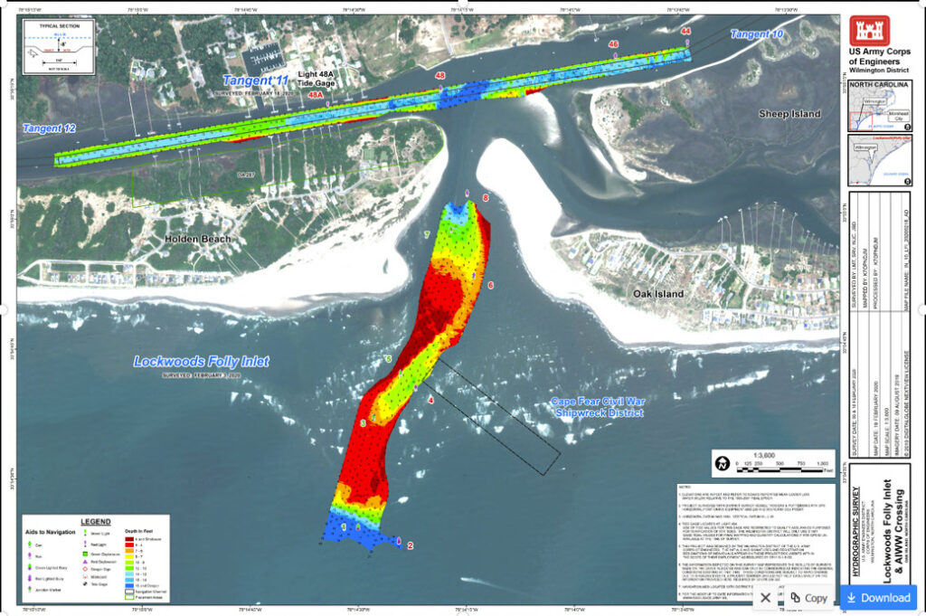 Sand build up in LWF Inlet causing issues as waterway waits for dredging
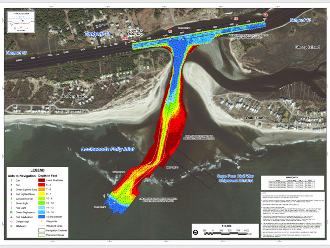 Lockwood Inlet Association warns boaters of broken pipe, other dangers inwaterway
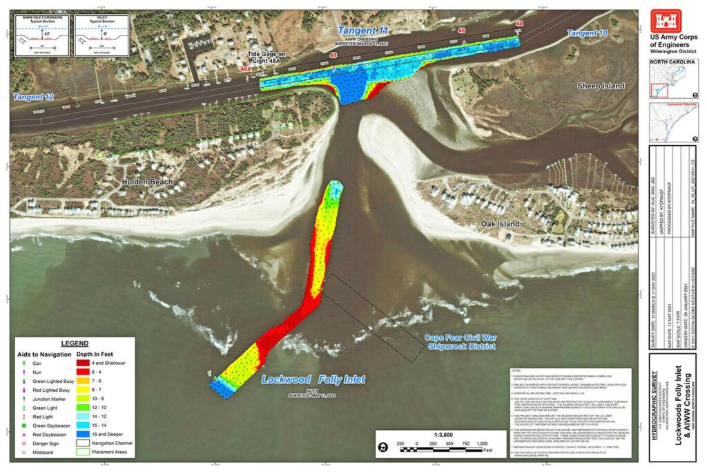 Lockwood Folly Inlet reaches danger point
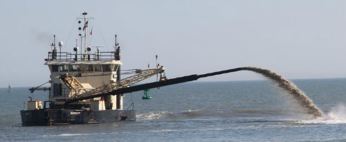 US Army Corps of Engineers set to complete dredging of dangerously shallow Brunswick County inlet
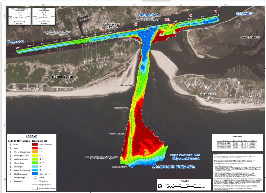


 NC Absent from Expanded Offshore Drilling Moratorium