
Lou’s Views
News & Views / August Edition
Calendar of Events –

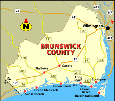
U.S. Open King Mackerel Fishing Tournament
October 5th thru October 7th
Southport
The U.S. Open King Mackerel Tournament has taken place since 1979 and is held annually the first week in October. The U.S. Open is one of the largest king mackerel tournaments on the East Coast and part of the SKA (Southern Kingfish Association) Tournament Trail. The tournament now attracts almost 400 boats annually.
For more information » click here

Riverfest
October 6th thru 8th
Wilmington
.
Wilmington’s Riverfest is celebrated in October since 1979 and runs from the foot of Market Street to Cape Fear Community College over a half mile of free family entertainment.
For more information » click here
![]()
Sunset at Sunset
October 7th
Sunset Beach
.
Held the first Saturday in October each year, Sunset at Sunset is the Town of Sunset Beach’s Community Block Party. The 15th annual autumn event is scheduled to happen again this year, in front of Ingram Planetarium on Sunset Boulevard in Sunset Beach.
For more information » click here
![]()
N.C. Oyster Festival
October 21st & 22nd
Ocean Isle Beach
.
.
The annual North Carolina Oyster Festival has taken place since 1978. Come celebrate everything Oyster with a variety of foods, crafts, contests, children’s activities, and musical performances at Mulberry Park in Shallotte. Signature Festival events include the Oyster Shucking Contest, Oyster Eating Contest, and Oyster Stew Cook-off.
For more information » click here

N.C. Festival by the Sea
October 28th & 29th
Holden Beach
Hosted by the Holden Beach Merchants Association this two day festival occurs on the last full weekend in October. This two day event is kicked off with a parade down the Holden Beach causeway. There is a fishing tournament, horseshoe tournament, and a sandcastle building contest. Vendors provide food, arts and crafts, amusement rides and other activities. There is live musical entertainment both days at the Holden Beach’s Pavilion.
For more information » click here
![]() Discover a wide range of things to do in the Brunswick Islands for an experience that goes beyond the beach.
Discover a wide range of things to do in the Brunswick Islands for an experience that goes beyond the beach.
For more information » click here.
Calendar of Events Island –
Shag Lessons
Are you interested in shag lessons? Join our interest list if you would like to attend a six week program at the Holden Beach Town Hall, starting mid-October. The fee will be $60 per person. Email [email protected] with the names of interested parties.
Pickleball Classes
Pickleball classes will be held every Monday starting at 8:30 a.m. and every Tuesday starting at 5:30 p.m. beginning August 28th at Bridgeview Park. The cost is $100 for the season for both residents and non-residents (or $180 for two classes per week for the season). Click here for more information.
 Concerts on the Coast Series
The Town’s summer concert series calendar has been released! Live performances featuring local musical groups are held at the pavilion on Sunday evenings from late May to early September. The concerts are free of charge.
For more information » click here
Turtle Talk
Two programs both are held every Wednesday during the summer at Town Hall. Children’s Turtle Time is at 4:00 p.m. with crafts, stories and activities for children ages 3 – 6. All children must be accompanied by an adult. Turtle Talk is an educational program at 7:00 p.m. for everyone else.
Parks & Recreation / Programs & Events
For more information » click here
Reminders –
 Free Cleanup Week
The next Free Cleanup Week at the Brunswick County Landfill will take place September 18th – 23rd. Brunswick County property owners and residents can dispose of all materials, except for regular household trash and hazardous waste, free of charge during Free Cleanup Week. Individuals can dispose of metal, tires, electronics, latex paint, clothing, shoes, used oil, oil filters, antifreeze, gasoline, fluorescent bulbs, used cooking oil, smoke detectors, household batteries, and yard debris in their designated area at the landfill during this week. Participants must show proof of Brunswick County property ownership or residency. Businesses and commercial vehicles will be charged normal tipping fees. For questions, contact Brunswick County Operation Services at (910) 253-2520 or email [email protected].
LOCATION
Brunswick County Landfill
172 Landfill Rd NE
Bolivia, NC 28422
HOURS OF OPERATION
Monday through Friday :30 a.m. until 5:00 p.m.
Saturday 7:30 a.m. until 3:00 p.m.

Pets on the Beach Strand
Pets – Chapter 90 / Animals / 90.20
From May 20th through September 10th it is unlawful to have any pet on the beach strand during the hours of 9:00am through 5:00pm.
Dogs on the Beach Video » click here

A Second Helping
.
Program to collect food Saturday mornings (8:00am to 10:30am) during the summer at the Beach Mart on the Causeway.
1) Nineteenth year of the program
2) Food collections have now exceeded 290,000 pounds
3) Collections will begin on Memorial Day weekend
4) Food is distributed to the needy in Brunswick County
For more information » click here
.
Hunger exists everywhere in this country; join them in the fight to help end hunger in Brunswick County. Cash donations are gratefully accepted. One hundred percent (100%) of these cash donations are used to buy more food. You can be assured that the money will be very well spent.
Mail Donations to:
A Second Helping
% Sharon United Methodist Church
2030 Holden Beach Road
Supply, NC 28462
Website:
http://www.secondhelping.us
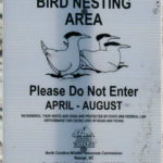
Bird Nesting Area
NC Wildlife Commission has posted signs that say – Bird Nesting Area / Please don’t disturb. The signs are posted on the west end beach strand around 1307 OBW.
People and dogs are supposed to stay out of the area from April through November
. 1) It’s a Plover nesting area
. 2) Allows migrating birds a place to land and rest without being disturbed

Mosquito Control
Current EPA protocol is that spraying is complaint driven
The Town is unable to just spray as they had in the past
. 1) Complaint based
. 2) Citizen request
. 3) Proactively monitor hot spots
They recommend that you get rid of any standing water on your property that you can
Urged everyone to call Town Hall if they have mosquito issues so that they can spray
Spraying is complaint based, so keep the calls coming!
 Solid Waste Pick-Up Schedule
GFL change in service, trash pickup will be twice a week. Starting the Saturday before Memorial Day through the Saturday after Labor Day: Pick-up is every Tuesday and Saturday from May 27th through September 30th
Please note:
. • Trash carts must be at the street by 6:00 a.m. on the pickup day
. • BAG the trash before putting it in the cart
. • Carts will be rolled back to the front of the house
Solid Waste Pick-up Schedule –
starting the Saturday before Memorial Day (May 27th) twice a week
Recycling –
starting after Memorial Day (May 23rd) weekly pick-up
Curbside Recycling
GFL Environmental is now offering curbside recycling for Town properties that desire to participate in the service. The service cost is $106.88 annually paid in advance to the Town of Holden Beach and consists of a ninety-six (96) gallon cart that is emptied every other week.
Curbside Recycling Application » click here
Curbside Recycling Calendar » click here.

Trash Can Requirements – Rental Properties
GFL Environmental – trash can requirements
Ordinance 07-13, Section 50.08
Rental properties have specific number of trashcans based on number of bedrooms.
* One extra trash can per every 2 bedrooms
§ 50.08 RENTAL HOMES.
(A) Rental homes, as defined in Chapter 157, that are rented as part of the summer rental season, are subject to high numbers of guests, resulting in abnormally large volumes of trash. This type of occupancy use presents a significantly higher impact than homes not used for summer rentals. In interest of public health and sanitation and environmental concerns, all rental home shall have a minimum of one trash can per two bedrooms. Homes with an odd number of bedrooms shall round up (for examples one to two bedrooms – one trash can; three to four bedrooms – two trash cans; five – six bedrooms – three trash cans, and the like).
Building Numbers
Ocean front homes are required to have house numbers visible from the beach strand.
Please call Planning and Inspections Department at 910.842.6080 with any questions.
§157.087 BUILDING NUMBERS.
(A) The correct street number shall be clearly visible from the street on all buildings. Numbers shall be block letters, not script, and of a color clearly in contrast with that of the building and shall be a minimum of six inches in height.
(B) Beach front buildings will also have clearly visible house numbers from the strand side meeting the above criteria on size, contrast, etc. Placement shall be on vertical column supporting deck(s) or deck roof on the primary structure. For buildingswith a setback of over 300 feet from the first dune line, a vertical post shall be erected aside the walkway with house numbers affixed. In all cases the numbers must be clearly visible from the strand. Other placements may be acceptable with approval of the Building Inspector..
![]()
BOC’s Meeting
The Board of Commissioners’ next Regular Meeting is scheduled on the third Tuesday of the month, September 19th

News from Town of Holden Beach
The town sends out emails of events, news, agendas, notifications and emergency information. If you would like to be added to their mailing list, please go to their web site to complete your subscription to the Holden Beach E-Newsletter.
For more information » click here
Volunteers needed
The Town is always looking for people to volunteer for their various boards and committees. If you are interested in serving, please fill out a resume form and submit it to [email protected].
 Elevators
Most states mandate that elevator systems be tested and inspected annually. Currently the state of North Carolina does not require annual inspections to be performed on all elevator systems. The use of unsafe and defective lifting devices imposes a substantial probability of serious and preventable injury to your family and guests. It is in the owner’s best interest to minimize injuries and liability by scheduling an annual safety inspection to ensure the safe operation of their elevator system.

Library
If you need something to keep you busy in this colder weather, make sure to visit the island library. The library is in the upstairs of Holden Beach Town Hall. All the books were donated. Patrons of the library don’t have to check out a book; they are on the honor system to return it.

Neighborhood Watch –
• Need to look out for each other
• Call 911 if you see or hear anything suspicious
• Fill out Keep Check Request Form if you will be out of town
• Pickup copy of Protecting Your Home..
Storm Events –
 Hurricane Vehicle Decals
Property owners will be provided with four (4) decals which will be included in their water bills. It is important that you place your decals on your vehicles immediately to avoid misplacing them. Decals will not be issued in the 24-hour period before an anticipated order of evacuation.
The decals are your passes to get back onto the island to check your property in the event an emergency would necessitate restricting access to the island. Decals must be displayed in the lower left-hand corner of the windshield, where they are not obstructed by any other items. Officials must be able to clearly read the decal from outside the vehicle. Please note that re-entry will NOT be allowed if a current, intact decal is not affixed to the windshield as designated.
EVACUATION, CURFEW & DECALS
What is a State of Emergency?
A proclamation by the Town which enacts special ordinances and/or prohibitions during emergency situations to protect the public, public health and property. These prohibitions can include limitations on movement, curfews, directing of evacuations, controlling ingress and egress to the emergency area, alcoholic beverages, and more. State of Emergencies are issued in accordance with N.C.G.S. 166A-19.22.
What is a curfew?
A curfew is an order, typically during a State of Emergency, which requires all persons in the affected areas to remain on their own property. During a curfew, you are not free to move about public domain areas or on others’ property. Violations of a curfew could lead to arrest in certain situations.
What is a voluntary evacuation?
A voluntary evacuation creates a recommendation for all parties in the affected area to get their affairs in order hastily and evacuated.
What is a mandatory evacuation?
A mandatory evacuation means you must leave the area in which an order has been issued. With recent changes to the laws in North Carolina, you no longer have the option of staying in an area under an order of mandatory evacuation.
Why is the sewer system turned off during a storm/event?
Often the sewer system is turned off during storms which have the potential to create significant flooding on the island. The system is turned off to protect its integrity. If it were left on, it could pose a significant threat to the public health. When the system is manually shut down, it also greatly reduces the time needed to bring it back up after an event which equates to getting residents and guests back on the Island much faster.
Why is there a delay for decal holders to get back on the island once a storm ends?
After a storm, many things must occur before even limited access can be allowed. Some of those things include making sure the streets are passable; the sewer system must be restarted to comply with State laws; the utilities (water, sewer, electricity, propane supplies) must be checked to ensure no safety risk are present; and the post-storm damage assessment team needs to perform an initial assessment.
Where can I get up-to-date information during and after a storm or State of Emergency?
You can sign up for the Town email service by clicking here. The newsletter, along with the Town’s website will be the main sources of information during an emergency situation. Links to the Town’s official Facebook and Twitter pages can be found on the website. You can also download our app for Apple and Android phones by accessing the app store on your smart phone and searching Holden Beach.
Please refrain from calling Town Hall and Police Department phone lines with general information questions. These lines need to remain open for emergencies, storm management and post-storm mitigation. All updates concerning re-entry, general access, etc. may be found on the Town’s website and other media outlets.
Why do I see others moving about the island during a curfew?
If a curfew order is in place, you must stay on your own property. You may see many other vehicles moving about the Island. We often receive assistance from other local, state, federal and contract personnel during events. It is likely these are the personnel you are seeing, and they are involved in the mitigation process for the event. Please do not assume that a curfew order has been lifted and/or you are free to move about the island.
Can I check my friends’ property for them?
If a curfew order is in place, you may ONLY travel to your personally owned property. Traveling about the Island to check on others’ property is not allowed. is in place, you may ONLY travel to your personally owned property. Traveling about
Who can obtain decals?
Only property owners and businesses who service the island can obtain a decal.
How do I get decals for my vehicle…?
If I am an owner?
Decals will be mailed out in water bills to property owners before the season starts. Those owners who need additional decals can contact Town Hall. A fee may apply, please check the current fee schedule.
If I am a renter?
You must contact the owner of the property to obtain a decal.
If I am a business owner on the Island?
You must contact Town Hall to obtain a decal.
If I am a business owner off the Island that provides services on the Island?
You must contact Town Hall for eligibility and to obtain a decal.
When does my decal expire?
All decals expire on the last day of the calendar year as indicated on the decal.
Where do I put my decal on my car?
Decals must be displayed in the lower left-hand corner of the windshield, where they are not obstructed by any other items to include window tinting, other decals, etc. Officials must be able to clearly read the decal from outside the vehicle. Please note that re-entry will not be allowed if a current, intact decal is not affixed to the windshield as designated.
How do I replace a decal if I get a new vehicle?
If you trade a vehicle or otherwise need a replacement decal, you may obtain them from Town Hall during normal business hours. A fee may apply, check the current fee schedule.
Can I obtain a decal right before an emergency occurs?
While most of the storms we deal with are tropical in nature with some type of advanced warning, we do experience many other types of events that could create a State of Emergency without warning. All eligible parties should obtain decals as early as possible each year to avoid being denied access to the Island. Decals shall not be issued during the 24-hour period prior to an anticipated order of evacuation so staff can concentrate on properly preparing the Town for the storm/event.
Can I use a tax bill or another document for re-entry?
No. You MUST have a decal to re-enter the Island until it is open to the general public.
How does re-entry after a storm during a State of Emergency work?
The bridge is closed to all vehicle access, except for official vehicles. Once those with proper decals are allowed access, they must conform with the current rules in place by the specific State of Emergency Order. After all hazards have been rendered safe, the bridge will be opened to the general public. A curfew could remain in effect however, to ensure the safety and security of the Island and its residents and guests. Please understand this process typically takes days to evolve and could be significantly longer, depending on the amount of damage sustained. Please refrain from calling for times for re-entry, as those are often not set on schedule. Instead, stay tunes to local media outlets and official social media accounts for accurate updates.
How can I check on my property if access is limited to the Island?
Once it is safe, property owners with valid decals will be allowed back on the Island after a storm/event. At this point, you can travel to your property, in accordance with the rules of the specific State of Emergency Order currently in place.
If you live out of the area, please do not travel to the Island until you are certain you will be allowed access. Stay tuned to those media outlets and email services that are of official nature for this information. Also, be certain you have your current, valid decal properly affixed to your vehicle.
It is a good idea to be sure your contact information is current with the Town tax office as this is the location Town officials will use in the event you need to be contacted.
For more information » click here
NC General Statute 166A-19.22
Power of municipalities and counties to enact ordinances to deal with states of emergency.
Synopsis – The governing body may impose by declaration or enacted ordinance, prohibitions, and restrictions during a state of emergency. This includes the prohibition and restriction of movements of people in public places, including imposing a curfew; directing or compelling the voluntary or mandatory evacuation of all or part of the population, controlling ingress and egress of an emergency area, and providing for the closure of streets, roads, highways, bridges, public vehicular areas. All prohibitions and restrictions imposed by declaration or ordinance shall take effect immediately upon publication of the declaration unless the declaration sets a later time. The prohibitions and restrictions shall expire when they are terminated by the official or entity that imposed them, or when the state of emergency terminates.
Violation – Any person who violates any provisions of an ordinance or a declaration enacted or declared pursuant to this section shall be guilty of a Class 2 misdemeanor.
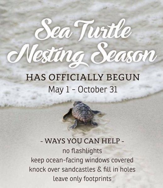
Turtle Watch Program –

Turtle Watch Program – 2023
• The first nest of the 2023 season was on 05/12/23 • Average annual number of nests is 57
• Current nest count – (70) as of 08/18/23
Members of the patrol started riding the beach every morning on May 1 and will do so through October looking for signs of turtle nests.
For more information » click here.
Sea turtles hatch in Holden Beach, Ocean Isle Beach
Groups in Holden Beach and Ocean Isle Beach recently announced sea turtle hatchlings that took place over the weekend. “The hatchlings are here! The HBTP is excited to share that the first sea turtle nest has hatched! The first nest laid on Holden Beach this season hatched on Thursday evening July 20. This was also the first nest to hatch in NC this year. In between thunderstorms that evening the adoption team helped 55 hatchlings into the water,” a Holden Beach Facebook post states. The town says that the nest was closed and inventoried Sunday evening, with the patrol finding 80 shells and 21 unhatched eggs. “Adoption teams from the HBTP are on the beach every evening watching nests that are expected to hatch within the next few days. Visitors are encouraged to look for the red shirts on the beach to learn more about the sea turtles that nest on our beach. The current nest count is 64 with 78 false crawls and 204 hatchlings have entered the water so far this year,” the post continues.
Read more » click here
Upon Further Review –
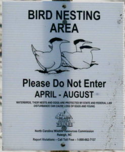 Wildlife Commission asks beachgoers to be mindful of nesting birds
Waterbirds are nesting and brood-rearing now through Aug. 31
Before hitting the beach this summer, visitors should remember to “share the shore” with beach-nesting birds, giving them, their eggs and chicks a wide berth. Waterbird nesting is now under way along the coast, and biologists with the N.C. Wildlife Resources Commission urge people to watch where they step on the beach because these birds are very sensitive to human disturbance. Eggs and chicks are well camouflaged and can be unintentionally stepped on and crushed by humans and pets. Getting too close to a nesting bird can cause it to fly off, leaving the eggs or chicks vulnerable to the elements or to predators. “Birds have their ways of letting you know when you’re too close,” said Carmen Johnson, the Wildlife Commission’s waterbird biologist. “They’ll call loudly and dive at you. Some species will pretend to have a broken wing to lure you or other perceived predators away from the nest and chicks.” Because beachgoers may not recognize bird-nesting habitats, the Wildlife Commission asks the public to observe the black-and-white signs posted by the agency and signs posted by agency partners around important beach-nesting areas and islands. The signs help people avoid nesting grounds from April 1 through Aug. 31, the sensitive nesting and brood-rearing season, and advise that entering an area can result in the loss of eggs or chicks. Wildlife Commission staff also remind boaters to be mindful of nesting birds on islands, particularly if they approach an island posted with the black-and-white signs. “You can help North Carolina’s waterbirds have a successful nesting season by observing them from outside the posted areas, and avoiding islands marked as bird-nesting areas, or unmarked islands where you see nesting birds,” Johnson said. “Some birds nest near the high tide line, and the likelihood of disturbing nests and stepping on flightless chicks is high.” Johnson added that it is especially important to adhere to the “no dogs” rule on the signs. Not only is it the law, but one dog can destroy an entire bird nesting colony in minutes. Some islands that serve as beach-nesting habitat are not marked with black-and-white signs, such as many of the state’s marsh islands in the sounds. Johnson recommends that people give these islands a buffer between their activities and any nesting birds. Likewise, not all nesting areas on the beach are posted, so coastal visitors and residents should always be aware of their surroundings. Beachgoers can help protect nesting shorebirds by: Keeping dogs on a leash at all times. Dogs may chase and harass birds, as well as trample nests, killing chicks or crushing eggs. Following the beach driving regulations. If driving is permitted, only drive on the lower part of the beach and drive slowly enough to avoid running over chicks. Disposing of trash properly when leaving the beach, including bait and scraps from cleaned fish, which can attract predators such as gulls, raccoons, feral cats and foxes. Discarding fishing line and kite string in an appropriate receptacle. These materials can entangle and kill birds and other wildlife if left on the beach. Abstaining from feeding gulls. Gulls are a major predator of young chicks and eggs. Avoiding flying drones and kites near nesting colonies. They may be mistaken for a predator. Cooperating with these simple steps and observing the posted signs will protect valuable bird resources and preserve our amazing beaches and wild waterfronts. For more information about beach-nesting waterbirds and how to protect them, down-load the “North Carolina’s Beach-Nesting Birds” document or visit the Wildlife Commission’s conserving webpage https://www.ncwildlife.org/Conserving/Conserving-North-Carolinas-Wildlife-Resources
Beacon
Corrections & Amplifications –
 Brunswick County shares details on new emergency alert system
Brunswick County on Tuesday shared details about its new emergency notification system, “ReadyBrunswick”. You can sign up for the alerts online on the county’s website. “The process begins when Brunswick County issues a message about a potential safety hazard or concern. Next, ReadyBrunswick sends a message through your primary contact path. If you don’t confirm receipt of the message, the system will try to reach your second contact path and continues trying to reach you until you confirm receipt,” a county announcement states.
The notifications can be sent via:
- Landline (Voice)
- VoIP (Voice over Internet Protocol)
- Mobile (Voice)
- Mobile SMS (Text Messaging)
You can download the Everbridge mobile app after registering to get the notifications on your mobile device. “If you need assistance registering online, call Brunswick County Emergency Services Monday through Friday from 8:30 a.m. to 5 p.m. at 910.253.5383 or email [email protected],” the announcement continues. The county says if you were already subscribed to the county’s old emergency alert system CodeRED, your contact information was moved to the new system. But if you want to update contact information or change preferences, you’ll still need to make a new account. “Existing Brunswick County CodeRED participants should receive an invitation within the next 7-10 days to set up their new account via email or text message. If you did not receive this invitation or you are not sure if you were subscribed to CodeRED, sign up for ReadyBrunswick as a new user at brunswickcountync.gov/e-alerts,” the announcement states.
Read more » click here
As Brunswick is ‘reunited’ with Wilmington’s metro area, here’s why it matters
Brunswick County is once again part of the Wilmington Metropolitan Statistical Area. On July 21, the U.S. Office of Management and Budget released a bulletin with revised delineations of metropolitan, micropolitan, and combined statistical areas.
Here are four things you need to know about the move.
What statistical area was Brunswick County assigned to before?
Brunswick County has previously been a part of the Wilmington Statistical Area, but in 2009, it was separated from its Cape Fear region counterparts — New Hanover and Pender counties — and assigned to the Myrtle Beach Metropolitan Statistical Area. The July 21 bulletin moves the county back into the Wilmington area.
What does this mean for the area?
Dr. Mouhcine Guettabi, associate professor of economics at the University of North Carolina Wilmington and regional economist, called the re-alignment a “good development for the area,” noting that the addition of Brunswick County makes the area a “larger labor market” and “highlights the connectedness across the three areas.” “This is important as it makes the area more attractive from an investment standpoint/future development and growth,” Guettabi wrote in an email. “Data from the Census shows already shows that there is significant commuting between New Hanover and Brunswick and this change in designation strengthens that link by making it clear that they should be considered one large MSA as opposed to two neighboring counties with weak ties.”
What do local leaders think about the move?
When Brunswick County was reassigned to the Myrtle Beach, South Carolina statistical area following the 2010 U.S. Census, many local leaders disagreed with the move. Many believed Brunswick had more common interests with New Hanover and Pender counties than it did with Myrtle Beach, a popular tourist destination with high-rise hotels located across the state line. Brunswick County Commissioner Frank Williams said he was “glad to see Brunswick County finally reunited with southeastern North Carolina in the Wilmington MSA.” “Our region of the state is one of the fastest-growing areas in the nation and being in the same statistical area with other southeastern North Carolina counties is a common-sense move that will benefit our economic development efforts,” Williams said.
How are these areas designated?
According to the bulletin from the Office of Management and Budget, to be classified as a Metropolitan Statistical Area there must be at least one urban area with a population of 50,000 or more people, plus “adjacent territory that has a high degree of social and economic integration with the core as measured by commuting ties.” Recent U.S. Census data shows Wilmington had a population of 115,451 on April 1, 2020. During that same time period, Pender County had a population of 52,217, and Brunswick County’s population was 136,693.
When does the move become official?
The bulletin included a memorandum from Shalanda Young, director of the Office of Management and Budget, advising this new document “updates and supersedes” the bulletin issued on March 6, 2020, and the new delineations “take effect immediately.”
Read more » click here
Previously reported – July 2021
Brunswick County Connections Stronger To New Hanover For MSA
In recent findings submitted to the Census Bureau, area officials say Brunswick County has a stronger worker connection to New Hanover County than South Carolina, a fact they say lends support for Brunswick’s return to the Wilmington MSA. Leaders with Business Alliance for a Sound Economy (BASE) and those from UNCW sent letters last week to the federal agency to add input to the rulemaking process that will help guide the new MSA designations. The Wilmington Chamber of Commerce and Cape Fear Collective were also partners in the effort. BASE and its partners have been focused on the 2020 Census and the MSA designations since Brunswick County was removed from the Wilmington Metropolitan Statistical Area (MSA) and placed into an MSA with Myrtle Beach in 2013, pushing for Brunswick’s return. With the local 2020 Census data anticipated to be released soon, federal officials will start looking at the information and other rules to draw metropolitan lines. Local officials submitted data and their insight as part of the Census Bureau’s public comment period on the proposed rules, which concluded May 20. “In addition to the natural growth, commuting patterns are one of the ways that urban areas are being defined in the 2020 Census,” said Tyler Newman, president, and CEO of BASE, in an email Monday. “Thanks to UNCW and Cape Fear Collective, we were able to analyze commuting pattern data and show the strong tie between Brunswick County and Wilmington. Of Brunswick County’s workforce, 27% commute to New Hanover County daily versus 3% to Horry. Between the natural growth of eastern Brunswick County and the strong commuting pattern tie (compared to Myrtle Beach), we feel like it is pretty clear that Brunswick County should be returned to Wilmington when the urban areas are drawn and MSA delineations are set,” Newman said. Since the urban area criteria standards were released, BASE has been working with the University of North Carolina Wilmington and local nonprofit Cape Fear Collective to analyze the rules that guide the designations and model how the area’s population growth may be impacted by the proposed rules, Newman wrote in his letter to the Census Bureau last week. In their findings, the organizations point to housing density and commuting patterns as two areas that could support Brunswick County’s swing back into the Wilmington MSA. Household and employment data shows the flow of Brunswick County residents between Brunswick and New Hanover counties for work, Newman said in his letter. A model produced by Cape Fear Collective (shown above) and sent to the Census Bureau indicates: 42.1% of Brunswick residents work in Brunswick County; 26.8% of Brunswick residents work in New Hanover County; 3% of Brunswick residents work in Horry County; 27.3% of Brunswick residents work in a North Carolina county other than New Hanover or Brunswick counties; and 0.9% of Brunswick residents work in a South Carolina county other than Horry, according to Newman’s letter. The organizations are also making a recommendation to support adding a rulemaking addition to include ferries, such as the state-funded Southport/Fort-Fisher ferry route, as a commuting connection. “We feel very strongly that Brunswick County is in the Wilmington MSA and the growth, commuting patterns prove it. Enhancing the ‘noncontiguous territory separated by exempted territory’ (commuting pattern) provisions to account for water-borne commuters would further refine and enhance the final output and better reflect the situation on the ground,” Newman said in his letter. “As we saw last time, once the MSA delineations are set, it can be many years before an opportunity arises to fix it and make it right,” he continued. In addition to the information sent to the Census Bureau from BASE, UNCW also submitted a letter in an email last week. Mark Lanier, assistant to UNCW Chancellor Jose Sartarelli, and assistant secretary to the UNCW Board of Trustees, noted that there are connections to the university, as well. “In March of 2020, there were 2,734 UNCW alumni residing in Brunswick County. In addition, in a typical semester, there are over 450 current UNCW students residing in Brunswick County. UNCW and Brunswick Community College (BCC) have a strong partnership, with 30 to 35 additional transfer students per semester from BCC enrolling at UNCW to complete their four-year degree. “As part of the worker flow data, there are approximately 125 permanent or temporary UNCW employees residing in Brunswick County. Moreover, these numbers are increasing as the northern and eastern sections of Brunswick County grow and provide more affordable housing. All of these numbers are in addition to the Brunswick County residents who come to UNCW for cultural events, athletic events, continuing adult education, various professional services, and more,” Lanier said in his letter. He also noted that population estimates indicate northern Brunswick County growing more quickly than the southern portion of the county. The university, he said, is in support of Brunswick County returning to the Wilmington MSA. Lanier also noted the university’s support in the proposed rules for increased emphasis on worker flow data, the ferry system being included in commuting patterns and housing density, as well as “proper consideration of connections between state institutions” such as those between Brunswick Community College and UNCW. “In summary, the connections between Brunswick and New Hanover counties are much stronger than Brunswick’s connections to South Carolina. This lends support to methodologies and rules that will return Brunswick County to the Wilmington MSA,” he said.
Read more » click here
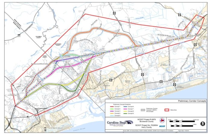
Here’s why a major road project connecting Myrtle Beach and Brunswick remains stalled
A combined effort by the North and South Carolina departments of transportation looks to connect two major highways near the states’ borders, but the project has been slow moving for a number of years. The Carolina Bays Parkway project looks to extend S.C. 31 from S.C. 9 in Horry County across the state line to U.S. 17 in southwestern Brunswick County. The project was first conceived nearly two decades ago in the early 2000s as a way to ease congestion in South Carolina’s Grand Strand communities and create an alternative route parallel to U.S. 17. The preliminary study area encompassed land largely in Brunswick County along U.S. 17, including Carolina Shores, Calabash and a portion of Shallotte. The project study area is roughly 19 miles long, including some 14 miles located in North Carolina and approximately five miles in South Carolina. Currently, motorists traveling between the two states by way of Brunswick County largely take an inefficient route down U.S. 17 through the Little River area before connecting to S.C. 31. Another route from Brunswick County to Horry County is two-lane – and largely residential – Hickman Road. With several planned developments approved to be built in the area over the next few years, an NCDOT study estimated many of the roads and intersections in the study area would approach, reach or exceed capacity limits within the decade. “The population within Horry and Brunswick counties has steadily increased, and is expected to continue to increase, along with the number of tourists to the area,” the project outlines. “Growth in population, tourism, and supporting services has resulted in an increase in mixed-purpose traffic on area roads.” This extension looks to improve traffic flow between the states.
Funding the project
According to the NCDOT, the project is estimated to total $552 million between the two states, with North Carolina’s portion estimated at $367 million and South Carolina’s at $185 million. At a recent meeting of the Wilmington Urban Area Metropolitan Planning Organization, NCDOT Division 3 Division Engineer Chad Kimes said South Carolina intends to extend S.C. 31, bringing six lanes of highway into North Carolina. Kimes said the NCDOT is still working on its connection. Kimes added that South Carolina’s portion of the project is fully funded while North Carolina’s portion has yet to be funded.
Timeline
The NCDOT is still working to determine a start date for the project, while SCDOT is expected to begin right of way acquisition next year. According to the NCDOT, an environmental impact document is expected to be submitted later this year, with a public hearing regarding the project anticipated for early 2024. Dates for when right of way acquisition in North Carolina and construction could begin have yet to be determined. According to the NCDOT, there are currently no upcoming public meetings scheduled regarding the project, but the public is asked to submit feedback on the department’s website.
Read more » click here
Previously reported – January 2023
Carolina Bays Parkway
A massive highway project looking to connect Brunswick County and Myrtle Beach could see major movement in 2023. The Carolina Bays Parkway project was first conceived in the early 2000s. Long awaited and highly anticipated, the project hopes to connect S.C. 31 and U.S. 17 in Brunswick County. With the need for a new route in southern Brunswick greater than ever with commercial and residential developments booming across the county, the project is now nearing some concrete milestones. Seven possible routes are undergoing more detailed studies to find the corridor with the least human and environmental impacts. N.C. Department of Transportation officials anticipate results from those studies will be shared with the public in February 2023 with a public comment period to follow. The project is expected to cost the two states $552 million and is only partially funded at this point.
Previously reported – January 2020
S.C. 31 extension concepts mapped at public meetings
Nine corridor concepts for extension of the Carolina Bays Parkway, aka S.C. 31, into Brunswick County were under scrutiny at two public meetings last week. The drop-in public information meetings were orchestrated by the North Carolina and South Carolina departments of transportation last Tuesday, Dec. 3, at Sea Trail in Sunset Beach and Wednesday, Dec. 4, in Little River to give residents opportunity to review maps and ask highway officials and consultants questions. The meetings were in “open house” format with no formal presentations. The project would extend the parkway from its current terminus at S.C. 9 in Horry County, S.C., to the U.S. 17 Shallotte Bypass in Brunswick County. The purpose of the project is to “improve the transportation network by enhancing mobility and connectivity for traffic moving in and through the project area,” according to highway officials. The nine concepts were presented on aerial photographs mapping each possibility, which would begin at the existing parkway/S.C. 9 interchange in South Carolina and end at the U.S. 17 Shallotte Bypass in North Carolina. The concepts reflected tie-in variations between those two points, five of which would go through Indigo Farms, the Bellamy family’s historic six-generation Century Farm straddling the state line. “All concepts would use existing U.S. 17 for approximately 6.3 miles between N.C. 904 between N.C. 904 (Longwood / Seaside roads) and N.C. 130 in Brunswick County,” reads information about the project at publicinput.com/carolina-bays-pkwy, where comments can be submitted, and maps of each concept viewed. In addition, the proposal calls for converting three existing intersections along this section of U.S. 17, including N.C. 904, Ocean Isle Beach Road and U.S. 17 Business/Main Street in Shallotte. The concepts were developed to “minimize impacts to natural and human environment features such as homes, businesses, wetlands and streams,” according to posted information. The concepts are also wider than the area needed for a future road. “The study corridors shown are generally 1,000 feet wide, but the recommended right-of-way width will be much narrower, in general approximately 400 feet,” reads information on the site. The public is invited to submit comments to NCDOT’s public engagement platform, which can be reached from its aforementioned project web page. In addition to maps and project details, contact information is available on the website. Questions can be directed to project manager Krista Kimmel at NCDOT, 5501 Barbados Blvd., Castle Hayne, NC 28429 or by calling 341-2000 or [email protected]. The contact person for South Carolina is Leah Quattlebaum, Pee Dee regional production engineer, SCDOT, P.O. Box 191, Columbia, SC 29202; phone 803-737-1751 or [email protected].
Read more » click here
NCDOT preparing to narrow down route options for Carolina Bays Parkway Extension
The North Carolina Department of Transportation will soon narrow down its list of route alternatives for the Carolina Bays Parkway Extension, a half-billion-dollar proposed highway project proposed to streamline traffic between southern Brunswick County and North Myrtle Beach. In December, NCDOT released nine route alternatives for the project that’s been studied since the mid-2000s. Shortly after, NCDOT hosted a pair of public meetings in Little River and in Sunset Beach to present information on the project and hear feedback from stakeholders. So far, the project has already received pushback from some factions of the community, including Sunset Beach Town Council, Brunswick County Board of Commissioners, and a multi-generational farm, Indigo Farms. Concerns have been raised that progress on the Horry County side of the project will outpace North Carolina’s, thereby locking in NCDOT to a route that the public hasn’t endorsed. Also, local tourism dollars are likely at stake, given the project would increase traffic flow to the Grand Strand. South Carolina is further along in funding the project, having already dedicated $125 million to it via a 2016 Horry County capital project sales tax referendum. Right-of-way acquisitions on the South Carolina side of the project will begin in 2022 ; NCDOT has not dedicated any funds for right-of-way acquisitions for its portion of the project. In all, the 19-mile proposed project will cost an estimated $552 million combined, with NCDOT required to cover roughly two-thirds of the total cost (14 miles of the project would run through North Carolina). Each of the nine proposed route alternatives would replace roughly 6 miles of existing roadway on Highway 17 and ultimately converge at the existing terminus in South Carolina between the existing Carolina Bays Parkway S.C. 31 at S.C. 9 (view all route alternatives).
Public comment
The public comment period on narrowing down the nine proposed alternatives ended Jan. 10 at midnight. Comments submitted before this deadline will be considered part of the public record, according to an NCDOT spokesperson, and comments submitted after will still be considered but not in the public record. Weigh in on the routes via a detailed project website, which includes the option to draw suggested lines, provide commentary, and rank alternatives. Once comments are analyzed, NCDOT will rule out a few of the proposed alternatives to narrow down which routes will be further studied in a detailed environmental analysis. NCDOT will narrow the routes down this spring; a Draft Environmental Impact Statement is expected this winter. Once the environmental study is available, a new public comment period will open, including public hearings. A preferred alternative (not the final decision, but the last step before it) could be selected by summer 2021.
Read more » click here

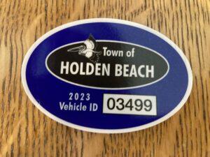
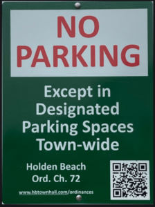
Paid Parking on Holden Beach
Paid parking will be enforced April 1st – October 31st in all Holden Beach designated parking areas. It will be enforced from 9:00 a.m. – 5:00 p.m. daily, with free parking before and after that time. All parking will use license plates for verification.
As a reminder, Holden Beach uses the “SurfCAST by Otto” parking solution. Annual passes are now available for purchase on the mobile app. You will also be able to purchase passes by scanning the QR-codes located on the parking signs for access to https://surfcast.ottoconnect.us/pay.
Rates for the 2023 season are as follows:
$4 per hour for up to four hours
$20 per day and for any duration greater than four hours
$80 per week (seven consecutive days)
Annual Passes:
$150 per calendar year for a single vehicle
$300 per calendar year for two vehicles
Handicap parking is free in designated handicap spaces and only with a valid license plate or hangtag.
Parking rates can be paid via credit card, debit card or PayPal.
Visit https://hbtownhall.com/paid-parking for more information and to view a table with authorized parking areas.
Odds & Ends –

As the population booms in Brunswick County, what places are needed to keep up?
Brunswick County’s rapid population growth has brought with it a surge in residential and commercial development, but there’s still more to be desired. Driving across the county, you’re bound to pass a couple of construction sites – the beginnings of a new housing development, apartment complex or grocery store. Here’s what’s behind the development and what’s coming soon to the county.
What kind of population growth has Brunswick County seen in recent years?
Brunswick County has seen rapid population growth in the past several years. The county continues to rank among the highest in the state for population growth, and data released this year suggests it’s also among the fastest growing counties in the nation. In July 2021, the county had an estimated population of 144,814. That number rose by 8,250 residents to 153,064 in July 2022 – a 5.7% increase. U.S. Census Bureau data released last year showed between April 2020 and July 2021, Leland grew by 8.6%, bringing its total population to 25,974. Early in the pandemic, four of the six places with the highest population increase in the state were in Brunswick County, with Northwest, Navassa and Calabash joining Leland in the list. According to the Economic Development Partnership of North Carolina, the state’s population growth is largely driven by cost of living, access to recreational activities, education, healthcare and climate.
Entertainment options lack in Brunswick
Perhaps one of Brunswick’s largest pulls is its beaches. The county has six beach towns: Caswell Beach, Oak Island, Ocean Isle Beach, Holden Beach, Sunset Beach and Bald Head Island. Aside from the access to beaches, golf courses and some historic sites, there are a lack of entertainment options in the county. One hope to satisfy that need is the potential project looking to bring a minor league baseball stadium to the county along U.S. 17 in Leland. The development would cover 1,400 acres near Brunswick Forest and include the stadium and entertainment complex as the anchor surrounded by an “entertainment district” to include restaurants, retail, commercial services and housing. The project has hit a few bumps along the way and is currently awaiting an economic feasibility study by the town of Leland before potentially moving forward. However, the Southport and Oak Island areas are getting an entertainment complex alongside more shopping and dining options.
Desires vary from town to town
On social media, residents are vocal about their desires for the county and their individual towns. Those desires vary from area to area. In more highly populated areas, such as Leland and Shallotte where big box stores and chain restaurants are present or on the way, residents seem to desire more unique, local spots. Gary Vidmar, former economic and community development director, told the StarNews before his June retirement that typically fast-food dining follows housing and population growth, then fine dining and other retail move in. “That’s something we’re hoping to see here in the coming years,” Vidmar said of fine dining in Leland. In places where long-established local options are available – such as Calabash, Southport and the smaller beach towns – there exists a desire for more access to mainstream, chain retail and dining options. With the growth Brunswick County has experienced over the last decade, one thing many residents have expressed concern about is the lack of medical professionals, including specialists and dentists. Many existing medical practices are not taking new patients, and doctors have large caseloads. Those who need to see a specialist may find themselves traveling to Wilmington or Myrtle Beach, South Carolina, and many still have to wait months for an appointment. With development also comes some impacts residents aren’t thrilled about, including the loss of trees to make way for housing and other projects. With every new development proposed come concerns from residents who desire the county’s green space to remain untouched. The county’s ordinances outline that clearcutting should be avoided when properties are undertaking development activity and selective removal of trees is “strongly encouraged.” Also, individual municipalities within the county also have ordinances restricting the removal of trees for development.
What’s coming?
Much of the county’s commercial and retail growth is occurring in its larger towns. In Leland, Lowe’s Home Improvement, Cook Out, 7-Eleven and more are under construction. Several more unleased commercial spaces have been approved and are in the works, meaning the potential for even more dining, retail and commercial development. Plans to build a Shallotte location of the popular breakfast chain Biscuitville were recently approved by the Shallotte Board of Aldermen, continuing the growth seen by the town. The county has also approved a host of new housing developments – namely in southern Brunswick County. With more people already here and more on the way, Brunswick’s commercial development likely won’t slow any time soon.
Read more » click here
This and That –

Shell yeah:
Here are the hot spots to find unique shells at Wilmington-area beaches
They’re usually up with the sun, long before the crowds flock to the Wilmington area beaches for a day of sunning and wading in the ocean. Those early risers — the shell seekers — will tell you when it comes to shelling, the early collector gets the treasure. Here are five things to know for those searching for shells along North Carolina’s beaches.
Where are the best places to find shells?
Mark Johnson, a Wilmington resident, has been collecting shells for as long as he can remember and now serves as the president of the North Carolina Shell Club. He’s found shells all over the state’s coast and around the country. He explained that when it comes to the “best” place for shells, that may change but it’s typically best to search more remote sections of beach. “The further you can get away from people, the better chances you have of finding something unique,” he said. He noted typically Lea-Hutaff Island and Figure Eight Island are good places to find shells. The North Carolina Shell Club’s website also recommends combing the beaches of Masonboro Island, the Fort Fisher Recreation Area, Bald Head Island and Bird Island, which is accessible by foot from the west end of Ocean Isle Beach. Johnson said renourishment projects at Oak Island and Holden Beach have enhanced shelling at those beaches. “Amazing things are coming up there, like fossils, sub fossils, and coral,” he said.
When is the best time to find shells?
While most shell-seekers head to the beach soon at sunrise, Johnson said the best time to find shells is right after a storm, especially a nor’easter, tropical storm, or hurricane. He adds the tides can also contribute to better-than-usual shelling, with exceptionally high tides washing more shells ashore and lower-than-normal tides exposing more of the beach.
What kinds of shells can people expect to find?
When it comes to Johnson’s favorite shell to find, he notes it’s difficult to pick just one. “My favorite type of shell is the one I happen to be looking for at the moment,” he joked. While he does have a special appreciation for the Scotch Bonnet, which is North Carolina’s state shell, it’s rare to find one in this area. Typically, whole Scotch Bonnets are only found intact between Cape Hatteras to Cape Lookout, but Johnson did find one while scuba diving off the coast of Wilmington. Some of the more common shells one may find are the Atlantic Oyster Drill, the Shark-eye Moon, the Common Northern Moon, and several species of Whelk, including Knobbed, Kiener’s, Lightning, Channeled, and Pear.
What about conservation and education?
When it comes to collecting shells, Johnson said he and the other club members practice conservation. He explained shells are living fauna, and the club promotes the collecting of dead shells — those washed up on the beach — and only the documentation through photographs and description of live shells in their habitat. Johnson also noted shelling can be important for science. He recalled while scuba diving off the coast of Wrightsville Beach, he found a species of shell that had not yet been discovered or described. He documented it, and had it named for his mother. “That just goes to show what one lone person can do for science,” he said.
How can I learn more about shells?
Founded in 1957, the North Carolina Shell Club is open to any person interested in collecting shells. Johnson said the club is dedicated promoting shells and the animals that make them, supporting citizen scientists, engaging in philanthropy by establishing scholarships and grants, and promoting a culture of camaraderie and fellowship.
For more information, visit the club’s website at ncshellclub.com. The Museum of Coastal Carolina, 21 E. Second Street, Ocean Isle Beach, also has a shell collection featuring more than 200 different shells.
Read more » click here
 Seashell hunters have flocked to this NC island near Myrtle Beach lately.
Visit the Carolina Seashellers Facebook group and you will find a sea biscuit bonanza. Seashell hunters post photos of piles of these golf ball-size objects that they found on the sands of Holden Beach, N.C. Shellers talk about taking trips to this island, just over an hour drive from downtown Myrtle Beach, S.C. Members even mail prime sea biscuit specimens to their group mates or sell them online. Read on to learn why seashell hunters prize these sea biscuits and why they are especially abundant at Holden Beach.
What are sea biscuits?
The sea biscuits found in the Carolinas are fossils of extinct echinoderms, said Coastal Carolina University marine biology professor Rob Young by email. They look like a puffy version of their relative, the sand dollar. Sea biscuits today grow in seagrass beds in the Caribbean and around the world, but no longer live in the Carolinas. The ones on Holden Beach are 34 to 55 million years old, from the Eocene epoch.
Why are people finding sea biscuits on Holden Beach?
The island’s recent beach renourishment is part of the reason, Young said. In 2022, crews dredged up sand from the sea floor and moved it to the beach. This process took fossils that were previously underwater and deposited them on the shore, to be found by shellers. Young said that in addition to the dredging, fossils exposed by underwater erosion are also swept ashore. Virginia resident Chuck Farthing was staying on Oak Island but drove to Holden Beach specifically to go shelling. He looked for both sea biscuits and olive shells.
How can I find them myself?
Members of Carolina Seashellers have many tips for finding sea biscuits on Holden Beach. Look between the Holden Beach Pier and the 800 addresses to the west. Walk the waterline at low tide or first thing in the morning. Look for the star design rolling in the surf or partially buried in the sand.
Read more » click here
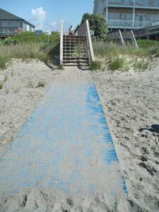
Rules panel sets Aug. 15 deadline on plan for beach mats
Ahh, the beach walkover. They’re as common along North Carolina’s developed ocean shorelines as seashells scattered on the sand. These typically wooden structures built to link private properties to the beach could, like the waters at low tide, eventually fade from shores. The North Carolina Coastal Resources Commission earlier this year submitted to the state Rules Review Committee proposed amendments that will allow coastal towns and counties, government agencies and private beachfront property owners to choose an alternative to traditional accessway structures – the beach mat. These portable, wood-like mats can be rolled out over sand to create a surface suitable for feet and wheels. And, they may reduce debris typically left behind from walkovers damaged and destroyed during coastal storms. The committee has given the North Carolina Division of Coastal Management an Aug. 15 deadline to submit technical corrections to the proposed rules, according to division officials. “If the RRC staff are satisfied with DCM’s responses, the proposed amendments will be on the RRC September agenda,” division officials said in an emailed statement. “If the proposed amendments are approved, the effective date will be Oct 1st.” The use of beach mats has in recent years have been gaining traction in North Carolina beach towns as a way to provide wheelchair accessibility from public accesses to the shore. Carolina Beach and Kure Beach in New Hanover County and Topsail Beach in Pender County have in recent years received variances from the commission to install matting on the beach seaward of the frontal dune, which is just landward of the beach, and to enhance handicap accessibility on the shore. The Coastal Resources Commission in 2021 amended the rules to allow beach matting for public accesses only. Until that rule change, only elevated, pile-supported structures built out no farther than the seaward toe of a frontal dune, those at the landward of the beach, were allowed. That limited the use of beach mats to local, state and federal governments, a decision made at the urging of the North Carolina Wildlife Resources Commission and U.S. Fish and Wildlife Service. Those agencies were concerned the use beach mats waterward of the frontal dune might adversely affect sea turtle habitat. The latest proposed rule changes would allow beach mats on the dry sand beach without a variance from the commissions long as they’re sponsored by a local government to provide handicap accessibility to the shoreline. The placement of those mats is subject to review by state and federal wildlife agencies. Division of Coastal Management officials explained in an email responding to Coastal Review’s questions that, under the proposed rule amendment, private property owners can install beach mats without a permit if they comply with the standards set for structural accessways. Mats must be no wider than 6 feet, no farther waterward than 6 feet from the toe of the dune, and must not require excavation or fill. “Residential application of matting material will need to adhere to the same standards previously approved for government entities, including installation at grade and prohibiting extension onto the public trust beach,” according to the division. “We anticipate that beachfront property owners will maintain these mats because of their personal financial investment in the mats. While there will likely be some debris resulting from storm displacement and/or long-term deterioration/abandonment of some access mats, we are hopeful that the overall amount of marine debris associated with coastal storms will be reduced by replacing the wood and metal materials associated with traditional walkovers, including boards, nails/screws, wires, and other materials.” The division is to work with local governments and local permitting officers “to monitor this closely and ensure that any mats not conforming to the State rules are brought into compliance (or they will need to go through the proper permitting process).” While the division has not seen a boost in requests from private property owners to install beach mats, it “has seen an uptick in unpermitted use of access mats along the coast over the past few years.” “In North Carolina we are seeing the need and the request more and more for Mobi-mats,” said Sandrine Carpentier, managing director of Mobi-mats, an outdoor portable access surfaces manufacturer in New Jersey. Mobi-mats have been growing in popularity, she said, because they are easy to install and remove, have demonstrated they can withstand coastal storms, and are more cost efficient than traditional beach access structures. The average cost of a beach mat is about $42 per foot in length, according to the division. Structural accessways cost on average of $333 per linear foot. Mobi-mats come with anchoring accessories, are made of recycled plastics and are 100% recyclable, Carpentier said. Their life span ranges between seven to 10 years, after which time they may be returned to the manufacturer where they will be recycled and used to make new matting. Holden Beach West Property Owners Association President Chad Hawk is anxiously awaiting what he hopes will be a final approval by the Rules Review Commission of the rule amendments. “We’re transitioning 100 percent with Mobi-mats as soon as we can do it,” he said. The gated community on the Brunswick County barrier island has mats or a hybrid of wooden walkways and stairs and matting at all seven of its beach accesses after receiving temporary approval to do so by the Coastal Resources Commission and the town. Using beach mats comes down to three factors, Hawk said: cost, convenience and that they do not cause the damage structural accessways do during coastal storms. Structural beach accesses are one of two of the association’s biggest expenditures, Hawk said. It costs anywhere between $30,000 and $50,000 to rebuild wooden walkways and stairs damaged in coastal storms. Property owners in the gated community must also pay to maintain the private roads in the community. “When a hurricane is coming, we can actually roll up our walkway, put it away and not lose our walkway,” Hawk said. “It’s also better for the overall dunes in the end. The honest truth is the way that the wood and everything was done there, there was a lot more damage issues that came with it.” One of the community’s beach mats did break loose during a storm and was found on a neighboring beach, he said. The mat, intact and with little damage, was returned to the owners association and replaced along the accessway. Chris Driver, an association manager with Seaside Management Inc. in Kitty Hawk, was first introduced to beach mats when he began recently managing a couple of communities in Duck. The oceanfront communities of Osprey and Sea Ridge both use mats at their private accesses to the beach. The mats were rolled up and removed to clear the way for beach nourishment and replaced after the project was completed. “For the most part, it just makes the walking to the beach tremendously easier for everybody, but especially elderly,” Driver said. “They’re very easy to roll up. One man can definitely do most of the work. They’re pretty easy to work with.” Coastal management officials advise beachfront property owners to contact their local Division of Coastal Management office or local permitting officer with questions regarding the use of beach mats.
Read more » click here
What the hole is that?
Giant beach holes left abandoned causing problems on NC beaches
Checking the beach during their morning tours, Surf City’s ocean rescue personnel are used to coming across some interesting sites − natural and manmade. But a giant hole deeper than a man? “That’s the biggest one I’ve seen in my six years here,” said Surf City Fire Chief Allen Wilson. “And it wasn’t dug with a plastic shovel, that’s for sure.” Beachgoers are famous for leaving stuff behind, sometimes accidently, when they go home for the day. But Wilson said there’s a big difference between a beach toy and a gaping hole that could easily swallow a child, become a potentially fatal obstacle for a nesting sea turtle or emerging hatchlings, and endanger rescue personnel rushing to an emergency situation. Wilson said officials with the Pender County beach town don’t want to be the “no-fun” police, since digging on the beach is a time-honored children’s tradition when visiting the ocean. “But at the end of the day, they pose a huge risk to people, especially at night,” the chief said, noting that Surf City officials found a second giant hole just a few days later on the beach. “And a lot of these big holes aren’t being built by kids.”
‘Gotten out of hand’
Visitors digging beach holes and then not filling them in is a problem that periodically pops up along the N.C. coast. At least seven Southeastern North Carolina beach towns − including Surf City, Ocean Isle Beach, Wrightsville Beach and Carolina Beach − have ordinances regulating beach holes. Some of the rules dictate how deep, wide and even when holes can be dug, and all of them require holes to be filled in by nightfall. Climate change is another concern as warmer temperatures fueled by greenhouse gases heating up the atmosphere draws more people to the beach for an evening stroll, where a lack of lights to protect nesting sea turtles and the natural beach atmosphere can find beachgoers accidently wandering into the giant holes. Sea-level rise and higher “King Tides,” which are the highest tides of the year tied to the moon’s orbit, means waves also are pushing farther inland, covering holes closer to the dune lines. A TikTok challenge last year to build ever deeper and bigger holes on the beach also caused alarm among local officials. The danger to nesting sea turtles, all species of which are protected by federal and state law, from abandoned deep holes was highlighted last September when rangers at the Cape Hatteras National Seashore came across a sea turtle that apparently abandoned its crawl after falling into a large hole. “From the tracks left by this adult nesting sea turtle, we can see that she accidently fell into a manmade hole,” stated a post on the seashore’s Facebook page. “Falling into this hole deterred her from laying a nest, but luckily she made it out on her own. Not all turtles or hatchlings are this lucky and can be injured or become stuck, leaving them open to predators and exposure.” Wilson said beachgoers tell him all the time that the tides will take care of the holes naturally, filling them in with water and sand. But the chief said the gigantic hole officials found near the Charlotte Avenue’s beach access had survived at least one tidal cycle, and was still dangerously deep. “Most people are accommodating when we remind them to fill in their holes before leaving, and in most cases the holes aren’t a big deal,” Wilson said. “But it’s gotten out of hand in some cases for sure.”
Read more » click here
Factoid That May Interest Only Me –
These 10 Brunswick County intersections have seen the most crashes since 2018
Brunswick County’s rapid growth has meant more traffic on its roads. With more than 30,000 homes permitted and currently under construction throughout the county, traffic is only going to increase, creating congestion on many of the county’s roads and highways. Additional traffic increases the likelihood of vehicle crashes. According to a North Carolina Department of Transportation database, there were 3,146 reportable crashes in 2022, resulting in 30 fatalities and 1,061 non-fatal injuries. Those numbers were an increase over 2018, which saw 2,852 reportable crashes with 24 fatalities and 1,154 non-fatal injuries. Many of those crashes occur at intersections. Here are the 10 intersections with the most reported crashes from June 1, 2018, to May 31, 2023.
10. U.S. 17 and N.C. 211
This intersection is where two of the county’s major thoroughfares come together, drawing motorists from all areas of the county. During the five-year period, this intersection saw 74 crashes.
9. U.S. 17 and Ocean Gate Plaza
Ocean Gate Plaza is a busy retail area in Leland, drawing many motorists to its offices, shops, and restaurants. Over the past 5 years, there have been 78 motor vehicle crashes reported at this intersection.
8. U.S. 17 and Ploof Road
This intersection is close to several shopping areas, including Leland Town Center and Ocean Gate Plaza and other commercial developments. The area is also home to the growing Ploof Road Business Park and several residential developments. This area ranks eighth for motor vehicle crashes with 78 reported over the past five years.
7. U.S. 17 and Old Waterford
Waterford, another busy development located along U.S. 17 in Leland, draws a significant amount of traffic with a number of medical offices, restaurants, banks, retail shops, and a large residential area. Since June 1, 2023, there have been 81 wrecks at this intersection.
6. N.C. 130 and Mt. Pisgah Road (SR 1130)
A bit off the beaten path is this intersection, located between Shallotte and Holden Beach. The area is mostly residential, but it can see heavy traffic, particularly during the summer months. The two roads come together in a “Y” shape, which could make it tricky for motorists. There have been 82 crashes reported at this intersection over the past five years.
5. Main Street and Smith Avenue
Over the past two decades, Shallotte has seen an explosion of commercial development centered around Main Street with much of it concentrated at or near the Smith Avenue intersection. Currently, the Smith Avenue intersection is home to the Shallotte Crossing Shopping Center, a Big Lots and Harbor Freight Tools. The area ranks fifth for motor vehicle crashes with 83 reported in the past five years.
4. N.C. 133 and N.C. 211
In addition to be a major thoroughfare for those heading toward Shallotte, it’s also home to much of the area’s commercial development, with two grocery stores, several restaurants and retail shops, and medical offices. It ranks fourth in the county for motor vehicle crashes with 99 occurring there since June 1, 2018.
3. I-140 and U.S. 74
In northern Brunswick County, this busy intersection sees traffic from both Leland and Wilmington. Home to development and industry, it is highly traveled. There have been 121 crashes reported in the last five years.
2. U.S. 17 and N.C. 87
Located near Winnabow, this intersection is popular for those traveling to Oak Island, Southport, and Boiling Spring Lakes. It also includes a large gas station with a Subway, drawing motorists from U.S. 17. There have been 153 crashes reported here since June 1, 2018.
1. U.S. 17 and U.S. 17 Business
U.S. 17 Business, also known as Old Ocean Highway, is a busy road with three schools, a daycare center, and the Brunswick County Government Center. This intersection has more motor vehicle crashes than any other Brunswick County intersection with 187 reported over the past five years.
Read more » click here
Beach Strand –
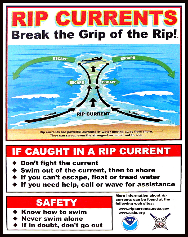
Most rip current deaths are preventable. Yet people keep drowning.
Beach-safety experts are frustrated by the mounting fatalities despite awareness campaigns and improved forecasts
Rip-current deaths in the United States are running ahead of last year’s pace — at least 29 since the beginning of the year — with peak beach season yet to come. Experts are warning the public to be aware of this largely hidden hazard ahead of Memorial Day weekend, traditionally one of the busiest beach weekends of the year. The risk of dangerous rip currents is expected to be particularly high this weekend along portions of the Southeast coast where a storm could produce heavy rain, gusty winds and rough seas. Experts say most rip-current fatalities can be prevented. Still, the number of annual rip-current deaths has steadily climbed since the National Weather Service began tracking them in 2010, reaching a record of 130 in 2021, then dipping to 85 last year. Rip currents were the third-leading cause of weather-related deaths from 2012 to 2021, behind only heat and flooding, according to the Weather Service, and in a typical year they kill more people than lightning, hurricanes or tornadoes. Rip currents are strong, narrow streams of water that flow away from the shoreline and can suddenly sweep swimmers out to sea. They can form on almost any beach with breaking waves, especially near low spots or breaks in sandbars, and near jetties or piers. Predicting where and when a rip current will form is difficult because of the many weather and ocean factors involved. The Weather Service cautions that “rip currents often form on calm, sunny days.” The Weather Service lists 26 rip-current deaths this year through April 27, not including three deaths believed to be caused by rip currents on April 28 in Destin, Fla., May 6 in Ocean City, Md., and May 12 at Cannon Beach, Ore. At this point last year, there were 19 total such deaths. Beach-safety experts are expressing frustration as fatalities trend higher again this year despite annual awareness campaigns, such as the United States Lifesaving Association’s National Beach Safety Week held every year during the week before Memorial Day, and recent improvements to rip current forecasts. “It is frustrating when we produce videos and graphics and educational information and release it at the beginning of each beach season, and it still misses so many people,” Scott Stripling, a senior meteorologist at the National Hurricane Center in Miami, said in an email. “The problem seems to be one of communication and/or lack of attention by the general public.”
Rip-current forecasts and warning signs
The Weather Service issues daily rip-current forecasts for beaches on the Atlantic Ocean, Gulf Coast, Southern California, Great Lakes, Puerto Rico and the U.S. Virgin Islands. The forecasts categorize the rip-current risk as low, moderate or high, and are informed by a rip-current model recently developed by NOAA that has made it possible to differentiate the risk between adjacent beaches. Previously the same forecast could span 100 miles or more. However, the model doesn’t enable reliable forecasts of the exact location and time of rip currents. These are influenced by a number of factors including wave characteristics, water levels, winds and the shape of a beach. Advances in artificial intelligence could help with rip-current detection — NOAA is partnering with the Southeast Coastal Ocean Observing Regional Association on a project using AI to detect rip currents in webcam imagery — but such efforts are still in their infancy. In some cases, there are visible clues to the existence of a rip current, such as a break in the waves, foamy water or objects being carried offshore, or darker water that is due to a break in a sandbar. Often, though, rip currents are difficult to see, or are best seen from a high point such as a dune line or the top of a beach access. Rip currents are particularly hard to spot in South Florida, where, the Weather Service says, they “consistently rank at or near the top of the list of deadliest weather-related hazards,” because there is not much sediment to darken or muddy the current at the shoreline. In Brevard County alone, home to nearly 72 miles of sandy beaches, there have been eight apparent rip-current drownings since November, all at beaches without lifeguards. “We have clear-water rips, so these offshore-flowing currents are very hard to detect,” Stephen Leatherman, a professor in the department of earth and environment at Florida International University, said in an email. “The best thing is to have lifeguards and for people to swim close to lifeguards. But lifeguards are very expensive, and Florida has 825 miles of good quality sandy beaches which are swimmable for most of the year.”
Warnings and tips for surviving a rip current
Rip currents flow at speeds up to 5 miles per hour. That may not sound fast, but it’s faster than many Olympic swimmers. If you are caught in a rip current, experts say not to swim directly back to shore against the current, which can quickly exhaust and drown you. Instead, swim parallel to the shore until you are out of the current, which is typically no wider than about 50 to 100 feet. You might also escape by floating or treading water, allowing the current to take you out just past the breaking waves where many rip currents tend to dissipate, and then circulate you back toward the shore. However, some rip currents can extend hundreds of yards offshore. If you see someone caught in a rip current, experts urge you not to risk your own life to attempt a swimming rescue unless you have been trained to do so and have a flotation device to assist you and the person in distress. Instead, you should get help from a lifeguard or call 911 if no lifeguard is present. You should also throw the victim something that floats, such as a lifejacket, body board, cooler or a ball, and yell instructions on how to escape. Experts agree that the best way to survive a rip current is to avoid it in the first place. That means checking the rip-current forecast before you enter the water, heeding warnings for rip currents or rough surf, and only swimming close to a lifeguard. The United States Lifesaving Association estimates the chance of someone’s drowning at a beach with a lifeguard at 1 in 18 million. “Lifeguards are trained to spot rip currents and other beach hazards and intervene as and when needed,” Chris Houser, a professor at the University of Windsor School of Environment and a longtime beach-safety researcher, said in an email. “While there is some evidence that individual beach users can be trained to spot rips, most beach users are not aware of what to look for.” U.S. lifeguards make an estimated 80,000 or more rip-current rescues each year, which suggests that education and warning messages are not reaching or are not resonating with as many people as experts would like. “If the lifeguards are flying precautionary flags, and there are signs on the lifeguard stand identifying the potential for rips in that area, and the National Weather Service and media have advertised that there is at least a moderate risk for rip currents to be present at your local beach, what else can we do?” the Weather Service’s Stripling said.
Read more » click here

Sharks are gathering off the NC coast. Here’s why and how you can avoid them.
Memorial Day is here, but before you decide to dip your toes in the ocean, you should know that you’re likely not alone (queue the Jaw’s music). A growing body of research indicates North Carolina might be a temporary gathering place for one of the ocean’s great apex predators. Great white sharks like Ormond, a nine foot, 600-plus pound subadult male are swimming off North Carolina and have been for weeks. “They’re there off (Wilmington’s) beaches basically from November until now,” said Chris Fischer, founder of OCEARCH, a global nonprofit organization dedicated to studying great whites and other species. Driven by a variety of factors, the waters off North Carolina are a brief vacation destination for great white sharks in the spring. The abundance of great whites might scare some, but researchers say there’s little to fear, and that this discovery could spur future shark research in North Carolina.
Is North Carolina a hub for great white sharks?
- Tracking data indicates North Carolina, particularly between Wilmington and the Outer Banks, is a large gathering place for great white sharks. Among the great whites OCEARCH tracks, five of the 10 sharks swimming off North Carolina pinged in their locations in the last three weeks.
- During OCEARCH’s most recent expedition to the Carolinas a few weeks ago, the team saw 2-3 great white sharks a day during good weather, which is uncommon. Typically, the organization sees a shark every third day or so during expeditions.
- The amount of great white sharks in the Carolinas, and how easy they are to find, is an exciting discovery for researchers because it could help create future opportunities to study the species.
- “I expect there will be a lot more white shark programs popping up in the Carolinas now that we’ve kind of identified when they’re here and how predictably they’re here,” Fischer said.
SHARK TRACKER: See the OCEARCH tracking map. / https://www.ocearch.org/tracker/
Why are sharks gathering off the Carolinas?
- The reason great white sharks spend so much time off North Carolina has to do ocean temperatures. Most great whites spend their winters between Cape Hatteras and the Gulf of Mexico but begin migrating north to New England and Canada in the spring.
- Great white sharks get “pinched” in the Carolinas for several weeks in the spring because waters north of Cape Hatteras haven’t warmed up enough to accommodate the apex predator. As a result, great white sharks might spend part of April and May in North Carolina, before moving north later in May and into June.
- While great white sharks are waiting to move north, researchers at OCEARCH believe mature adults might be using the opportunity to mate. Based on the white sharks OCEARCH has studied, mature adults appear to be “potentially reproductively ripe,” meaning the waters off North Carolina could be a breeding ground for great white sharks.
What can you do to avoid an encounter with a shark?
- In 2022, there were two unprovoked shark bites in North Carolina, out of 41 cases nationally, according to the International Shark Attack File, which is maintained by the Florida Museum of Natural History. Since 1935, Brunswick County (17) followed by New Hanover County (15) have had the most unprovoked shark attacks of any county in North Carolina.
- Shark encounters and attacks are incredibly rare. More people have been killed by dogs, bears, holes in the sand and lightning than by sharks, according to the International Shark Attack File.
- Fischer recommends beachgoers observe their surroundings before they get in the water. Swimmers should avoid areas where marine species appear to be hunting such as birds diving into the water, bait balls or more, because predators tend to get attracted to those activities.
Read more » click here
 Jellyfish and Portuguese Man of War have been spotted along the surrounding area beaches already this season and the little floating creatures can pack a punch. Often times beachgoers will spot them washed up on shore and other times they can be spotted in the water, but it is best to avoid them when you can. “While all jellyfish sting, not all contain poison that hurts humans. Be careful of jellies that wash up on shore, as some can still sting if tentacles are wet. NOAA recommends that if you are stung by a jellyfish to first seek a lifeguard to give first aid. If no lifeguards are present, wash the wound with vinegar or rubbing alcohol,” NOAA suggests. And what about that … other method of treating stings? Turns out, it’s a myth. In fact, urine can actually aggravate the stinging cells of jellyfish, making things worse. These cells, which detach and stick into the skin of prey, can continue to inject venom. Urine, as well as fresh water, can cause an imbalance to the salt solution surrounding the stinging cells, causing them to continue to fire. According to Scientific American, if you don’t have vinegar or rubbing alcohol, rinsing with saltwater may be your best bet.
At the beach? Don’t pop the ‘balloons!’
We’ve definitely had some windy weather in the past few days. And on the coast, those winds bring with it an interesting sighting! The Cape Lookout National Seashore Park posted on Facebook about some very temptingly poppable-looking things that have been washing up on their beaches. These little “balloons” are gas-filled floats that keep the Man-o-War jellyfish afloat as they drift through the ocean. The winds can pick these floats up and they can wind up on the beach, but the folks at the park caution that no matter how tempting it is, you should not pop these things! “Give them a wide berth,” the Facebook post ways. These are carnivorous jellyfish and use their dangling tentacles to kill their prey. Even washed ashore, the tentacles still pack a punch, so don’t mess with the balloons! Stepping on it will hurt!
Read more » click here
Portuguese man o’ war
The man-of-War are not usually in the area unless pushed to the coast by wind and ocean currents. It is a purple-blue color and can be up to 10 inches long. The Portuguese man o’ war (Physalia physalis), is not a jellyfish but related to the species and is highly venomous. It has numerous venomous microscopic nematocysts which deliver a painful sting powerful enough to kill fish. Stings can result in intense joint and muscle pain, headaches, shock, collapse, faintness, hysteria, chills, fever, nausea, and vomiting. Severe stings can occur even when the animal is beached or dead. Although it superficially resembles a jellyfish, the Portuguese man o’ war is in fact a siphonophore. Like all siphonophores, it is a colonial organism, made up of many smaller units called zooids. All zooids in a colony are genetically identical, but fulfill specialized functions such as feeding and reproduction, and together allow the colony to operate as a single individual.

 Staying safe at the beach: Rip currents, jellyfish, sharks, and other hazards
A trip to the beach can turn deadly (or painful) due to natural hazards but being aware of risks and mitigating hazards is a good way to prevent problems.
Picture this: warm weather, blue skies, and your toes in the sand — it sounds like a perfect lazy summer day at the beach. Maybe you decide to cool down in the ocean and find yourself bobbing around when suddenly you realize you are a little too far out. As panic sinks in and you start to swim towards dry land you realize your efforts are in vain and your whole body is getting tired, all the while you are drifting further into the Atlantic — you have gotten stuck in a rip current. It’s not the only potential danger in the ocean, though. There are also sharks. And, of course, there are some things on shore that ruin your day at the beach, too, including stepping on jellyfish and, of course, good old-fashioned sunburn.
Rip currents
According to the U.S. Lifesaving Association (USLA), 80 percent of all ocean rescues are related to rip currents and annually more than 100 fatalities across the country are due to rip currents. While it is obvious that swimming at a beach with lifeguards is one of the safer options, there are plenty of area beaches that lack lifeguards or maybe ocean rescue season has not started just yet. So, what is the best course of action for surviving a rip current? According to the National Weather Service, there are several things swimmers should keep in mind when dealing with these often-unseen dangers.
- Relax. Rip currents don’t pull you under.
- A rip current is a natural treadmill that travels an average speed of 1-2 feet per second but has been measured as fast as 8 feet per second — faster than an Olympic swimmer. Trying to swim against a rip current will only use up your energy; energy you need to survive and escape the rip current.
- Do NOT try to swim directly into to shore. Swim along the shoreline until you escape the current’s pull. When free from the pull of the current, swim at an angle away from the current toward shore.
- If you feel you can’t reach shore, relax, face the shore, and call or wave for help. Remember: If in doubt, don’t go out!
- If at all possible, only swim at beaches with lifeguards.
- If you choose to swim on beaches without a lifeguard, never swim alone. Take a friend and have that person take a cell phone so he or she can call 911 for help.
Sharks
Sharks are a fear on most every swimmer’s mind, regardless of the actual dangers posed by the large predatory fish. “NOAA states that while shark attacks are rare, they are most likely to occur near shore, typically inshore of a sandbar or between sandbars where sharks can be trapped by low tide, and near steep drop-offs where sharks’ prey gather. While the risks are small, it’s important to be aware of how to avoid an attack,” according to previous reporting.
Suggestions from NOAA for reducing the risk of a shark attack include:
- Don’t swim too far from shore.
- Stay in groups – sharks are more likely to attack a solitary individual.
- Avoid being in the water during darkness or twilight when sharks are most active.
- Don’t go in the water if bleeding from a wound – sharks have a very acute sense of smell.
- Leave the shiny jewelry at home – the reflected light resembles fish scales.
- Avoid brightly-colored swimwear – sharks see contrast particularly well.
Sunburns
Most everyone has experienced a sunburn at one point in their life and while not often thought as a major concern for many, overexposure to UV light can cause serious long-term problems including skin cancer. The Centers for Disease Control and Prevention (CDC) recommends using at least S.P.F. 15 sunscreen at least 15 minutes prior to sun exposure. Wearing a hat, long sleeves, and other protective clothing is also recommended to keep skin protected.
Jellyfish
Jellyfish and Portuguese Man of War have been spotted along the beaches of New Hanover County and surrounding area beaches already this season and the little floating creatures can pack a punch. Often times beachgoers will spot them washed up on shore and other times they can be spotted in the water, but it is best to avoid them when you can. “While all jellyfish sting, not all contain poison that hurts humans. Be careful of jellies that wash up on shore, as some can still sting if tentacles are wet. NOAA recommends that if you are stung by a jellyfish to first seek a lifeguard to give first aid. If no lifeguards are present, wash the wound with vinegar or rubbing alcohol,” NOAA suggests. And what about that … other method of treating stings? Turns out, it’s a myth. In fact, urine can actually aggravate the stinging cells of jellyfish, making things worse. These cells, which detach and stick into the skin of prey, can continue to inject venom. Urine, as well as fresh water, can cause an imbalance to the salt solution surrounding the stinging cells, causing them to continue to fire. According to Scientific American, if you don’t have vinegar or rubbing alcohol, rinsing with salt water may be your best bet.
Read more » click here
How to Collect Seashells
“It helps to have a search image in your mind,” says José H. Leal, the science director and curator at the Bailey-Matthews National Shell Museum in Florida. Research ahead of time what kind of mollusks you might encounter so that your eyes are primed to pick out specific shapes and colors. Leal has collected seashells since he was a boy in Rio de Janeiro. On his first trip to New York, in his 20s, he was so shell-focused that he dove to the sidewalk before realizing that what he thought were small, unusual clams were actually pistachio shells. “You get fixated,” he says. Consult a tide chart; go out within an hour of low tide when the beach is most exposed. Storms tend to wash more shells ashore in the winter months. In popular shelling destinations such as Sanibel Island, near where Leal lives, collectors often search at night to avoid competition. (If turtles are nesting in the area, avoid using flashlights, which disrupt brooding females and disorient their hatchlings.) If shells are abundant, pick a spot and settle in. Rather than hoard shells, take only the most beautiful specimens of each variety. Make sure the shell is uninhabited. With the spiral-shaped gastropods, you should be able to see the creature. “A shell is usually much heavier when there’s an animal inside,” Leal says. Know the relevant regulations; many places curtail or outright ban the collection of shells, and the United States has various import restrictions, including a prohibition on queen conch shells from the Caribbean. The urge to beachcomb is natural, however. Humans have been using mollusk exoskeletons as art, adornment, currency, and tools since before we were even human beings. (Scientists recently discovered distinct hash marks on a freshwater mussel shell they believe were engraved by our extinct ancestor Homo erectus.) Still, Leal is worried about the future of marine mollusks, given how vulnerable they are to pollution and ocean acidification. Maybe your urge to collect these unoccupied calcium-carbonate dwellings can serve as a sort of gateway drug. “Once you get a love for shells,” Leal says, “I hope you learn to care about the animals that make them.”
Read more » click here
Hot Button Issues –
Subjects that are important to people and about which they have strong opinions

Climate
For more information » click here
There’s something happening here
What it is ain’t exactly clear
U.S., European heat waves ‘virtually impossible’ without climate change, new study finds
The life-threatening heat waves that have baked U.S. cities and inflamed European wildfires in recent weeks would be “virtually impossible” without the influence of human-caused climate change, a team of international researchers said Tuesday. Global warming, they said, also made China’s recent record-setting heat wave 50 times more likely. Soaring temperatures are punishing the Northern Hemisphere this summer. In the U.S., more than 2,000 high temperature records have been broken in the past 30 days, according to federal data. In Southern Europe, an observatory in Palermo, Sicily, which has kept temperature records on the Mediterranean coast since 1791, hit 117 degrees Fahrenheit, Monday, shattering its previous recorded high. And in China, a small northwest town recently recorded the hottest temperature in the country’s history. July is likely to be the hottest month on Earth since records have been kept. “Without climate change we wouldn’t see this at all or it would be so rare that it would basically be not happening,” said Friederike Otto, a climate scientist at Imperial College London, who helped lead the new research as part of a collaborative group called World Weather Attribution. El Niño, a natural weather pattern, is likely contributing to some of the heat, the researchers said, “but the burning of fossil fuels is the main reason the heatwaves are so severe.” Global temperatures have increased nearly 2 degrees Fahrenheit since the start of the Industrial Revolution, when humans started burning fossil fuels such as coal and natural gas in earnest. To determine what role that warming has played on the current heat waves, the researchers looked at weather data from the three continents and used peer-reviewed computer model simulations to compare the climate as it is today with what it was in the past. The study is a so-called rapid attribution report, which aims to explain the role of climate change in ongoing or recent extreme weather events. It has not yet been peer-reviewed. The researchers found that greenhouse gas emissions are not only making extreme heat waves — the world’s deadliest weather events — more common, but that they’ve made the current heat waves hotter than they would have otherwise been by multiple degrees Fahrenheit — a finding, Otto said, that wasn’t surprising. Bernadette Woods Placky, chief meteorologist at Climate Central, who wasn’t involved in the research but had reviewed its findings, agreed with that assessment. “It is not surprising that there’s a climate connection with the extreme heat that we’re seeing around the world right now,” Placky said. “We know we’re adding more greenhouse gases to our atmosphere, and we continue to add more of them through the burning of fossil fuels. And the more heat that we put into our atmosphere, it will translate into bigger heat events.” Even a small rise in temperatures can lead to increased illness and death, according to the World Health Organization. Hot temperatures can cause heat exhaustion, severe dehydration and raise the risk of having a heart attack or stroke. Those risks are even higher in low-income neighborhoods and in communities of color, where research has found temperatures are often hotter than in white neighborhoods. Heat waves in Europe last summer killed an estimated 61,000 people — most of them women — according to a recent study published in the journal Nature. A stifling heat dome in the Pacific Northwest in 2021 is believed to have killed hundreds in Washington, Oregon and British Columbia. “Dangerous climate change is here now,” said Michael Wehner, a senior scientist at Lawrence Berkeley National Laboratory, who studies how climate change influences extreme weather and has published work on the 2021 heat dome. “I’ve been saying that for 10 years, so now my saying is, ‘dangerous climate change is here now and if you don’t know that, you’re not paying attention.'”
Read more » click here
It’s official: Scientists confirm July was the hottest month ever recorded
- Global air and ocean temperatures soared to a record high in July, according to the EU’s climate change service Copernicus.
- “These records have dire consequences for both people and the planet exposed to ever more frequent and intense extreme events,” said Samantha Burgess, deputy director of the Copernicus Climate Change Service.
- C3S and the U.N.’s World Meteorological Organization recently recognized the first three weeks of July as hottest three-week period on record.
Global air and ocean temperatures soared to a record high in July, according to the EU’s climate change service Copernicus, deepening concern among climate scientists at a time when a spate of heat records suggest the planet has entered uncharted territory. The EU’s Copernicus Climate Change Service (C3S) said Tuesday that the global average surface air temperature in July was confirmed to be the highest on record for any month. July was found to be a whopping 1.5 degrees Celsius warmer than the average for the 1850-1900 period and 0.33 degrees Celsius warmer than the previous warmest month of July 2019. Meanwhile, global average sea surface temperatures continued to rise in July, the EU’s climate monitor said, after a long period of unusually high temperatures stretching back to April. For the month as a whole, the planet’s average sea surface temperature was 0.51 degrees Celsius above the 1991 to 2020 average. The data, which is collated from the measurement of satellites, ships, aircraft and weather stations around the world, follows a flurry of record-breaking heat waves across multiple regions. Vast parts of Europe, North Africa, the Middle East and Asia have suffered from scorching heat in recent weeks, while South American countries have been gripped by record-breaking temperatures in the middle of winter. “These records have dire consequences for both people and the planet exposed to ever more frequent and intense extreme events,” Samantha Burgess, deputy director of C3S, said in a statement. “Even if this is only temporary, it shows the urgency for ambitious efforts to reduce global greenhouse gas emissions, which are the main driver behind these records,” she added. C3S and the U.N.’s World Meteorological Organization recently recognized the first three weeks of July as hottest three-week period on record. The record heat affecting communities across the globe is fueled by the climate emergency. Scientists say the extreme weather events underscore the urgency of cutting greenhouse gas emissions as quickly and deeply as possible.
‘Just the beginning’
C3S said 2023 was the third-hottest on record in the year to date at 0.43 degrees Celsius above the recent average. The gap between this year and 2016 — the hottest year on record — is expected to narrow in the coming months. That’s because the latter months of 2016 were relatively cool, C3S said, while the remainder of 2023 is poised to be comparatively warm as the current El Niño event develops. El Niño is a naturally occurring climate pattern that contributes to higher temperatures across the globe. The U.N. weather agency declared the onset of El Niño on July 4, warning its return could pave the way for extreme weather conditions. Speaking at the U.N. headquarters in New York City late last month, Secretary-General António Guterres warned that “the era of global boiling” has arrived. “For scientists, it is unequivocal — humans are to blame,” Guterres said on July 27. “All this is entirely consistent with predictions and repeated warnings. The only surprise is the speed of the change. Climate change is here. It is terrifying, and it is just the beginning.”
Read more » click here

Flood Insurance Program
For more information » click here

National Flood Insurance Program: Reauthorization
Congress must periodically renew the NFIP’s statutory authority to operate. On December 23, 2022, the President signed legislation passed by Congress that extends the National Flood Insurance Program’s (NFIP’s) authorization to September 30, 2023.
Congress must now reauthorize the NFIP
by no later than 11:59 pm on September 30, 2023.

FEMA’s New Rate-Setting Methodology Improves Actuarial Soundness but Highlights Need for Broader Program Reform
FEMA’s National Flood Insurance Program is charged with keeping flood insurance affordable and staying financially solvent. But a historical focus on affordability has led to insurance premiums being lower than they should be. The program hasn’t collected enough revenue to pay claims and has had to borrow billions from the Treasury. FEMA revamped how it sets premiums in 2021—more closely aligning them with the flood risk of individual properties. But affordability concerns accompany the premium increases some will experience. We recommended that Congress consider creating a means-based assistance program that’s reflected in the federal budget.
What GAO Found
In October 2021, the Federal Emergency Management Agency (FEMA) began implementing Risk Rating 2.0, a new methodology for setting premiums for the National Flood Insurance Program (NFIP). The new methodology substantially improves ratemaking by aligning premiums with the flood risk of individual properties, but some other aspects of NFIP still limit actuarial soundness. For example, in addition to the premium, policyholders pay two charges that are not risk based. Unless Congress authorizes FEMA to align these charges with a property’s risk, the total amounts paid by policyholders may not be actuarially justified, and some policyholders could be over- or underpaying. Further, Congress does not have certain information on the actuarial soundness of NFIP, such as the risk that the new premiums are designed to cover and projections of fiscal outlook under a variety of scenarios. By producing an annual actuarial report that includes these items, FEMA could improve understanding of Risk Rating 2.0 and facilitate congressional oversight of NFIP.
Risk Rating 2.0 is aligning premiums with risk, but affordability concerns accompany the premium increases. FEMA had been increasing premiums for a number of years prior to implementing Risk Rating 2.0. By December 2022, the median annual premium was $689, but this will need to increase to $1,288 to reach full risk. Under Risk Rating 2.0, about one-third of policyholders are already paying full-risk premiums. Many of these policyholders had their premiums reduced upon implementation of Risk Rating 2.0. All others will require higher premiums, including 9 percent who will eventually require increases of more than 300 percent. Further, Gulf Coast states are among those experiencing the largest premium increases. Policies in these states have been among the most underpriced, despite having some of the highest flood risks.
Annual premium increases for most policyholders are limited to 18 percent by statute. These caps help address some affordability concerns in the near term but have several limitations.
- First, the caps perpetuate an unfunded premium shortfall. GAO estimated it would take until 2037 for 95 percent of current policies to reach full-risk premiums, resulting in a $27 billion premium shortfall (see figure below). The costs of shortfalls are not transparent to Congress or the public because they are not recognized in the federal budget and become evident only when NFIP must borrow from the Department of the Treasury after a catastrophic flood event.
- Second, the caps address affordability poorly. For example, they are not cost-effective because some policyholders who do not need assistance likely are still receiving it. Concurrently, some policyholders needing assistance likely are not receiving it, and the discounts will gradually disappear as premiums transition to full risk.
- Third, the caps keep NFIP premiums artificially low, which undercuts private-market premiums and hinders private-market growth.
An alternative to caps on annual premium increases is a means-based assistance program that would provide financial assistance to policyholders based on their ability to pay and be reflected in the federal budget. Such a program would make NFIP’s costs transparent and avoid undercutting the private market. If affordability needs are not addressed effectively, more policyholders could drop coverage, leaving them unprotected from flood risk and more reliant on federal disaster assistance. Addressing affordability needs is especially important as actions to better align premiums with a property’s risk could result in additional premium increases.
FEMA has had to borrow from Treasury to pay claims in previous years and would have to use revenue from current and future policyholders to repay the debt. NFIP’s debt largely is a result of discounted premiums that FEMA has been statutorily required to provide. In addition, a statutorily required assessment has the effect of charging current and future policyholders for previously incurred losses, which violates actuarial principles and exacerbates affordability concerns. Even with this assessment, it is unlikely that FEMA will ever be able to repay the debt as currently structured. For example, with the estimated premium shortfalls, repaying the debt in 30 years at 2.5 percent interest would require an annual payment of about $1.9 billion, equivalent to a 60 percent surcharge for each policyholder in the first year. Such a surcharge could cause some policyholders to drop coverage, leaving them unprotected from flood risk and leaving NFIP with fewer policyholders to repay the debt. Unless Congress addresses this debt—for example, by canceling it or modifying repayment terms—and the potential for future debt, NFIP’s debt will continue to grow, actuarial soundness will be delayed, and affordability concerns will increase.
Risk Rating 2.0 does not yet appear to have significantly changed conditions in the private flood insurance market because NFIP premiums generally remain lower than what a private insurer would need to charge to be profitable. Further, certain program rules continue to impede private-market growth. Specifically, NFIP policyholders are discouraged from seeking private coverage because statute requires them to maintain continuous coverage with NFIP to have access to discounted premiums, and they do not receive refunds for early cancellations if they switch to a private policy. By authorizing FEMA to allow private coverage to satisfy NFIP’s continuous coverage requirements and to offer risk-based partial refunds for midterm cancellations replaced by private policies, Congress could promote private-market growth and help to expand consumer options.
Why GAO Did This Study
NFIP was created with competing policy goals—keeping flood insurance affordable and the program fiscally solvent. A historical focus on affordability has led to premiums that do not fully reflect flood risk, insufficient revenue to pay claims, and, ultimately, $36.5 billion in borrowing from Treasury since 2005. FEMA’s new Risk Rating 2.0 methodology is intended to better align premiums with underlying flood risk at the individual property level. This report examines several objectives, including (1) the actuarial soundness of Risk Rating 2.0, (2) how premiums are changing, (3) efforts to address affordability for policyholders, (4) options for addressing the debt, and (5) implications for the private market. GAO reviewed FEMA documentation and analyzed NFIP, Census Bureau, and private flood insurance data. GAO also interviewed FEMA officials, actuarial organizations, private flood insurers, and insurance agent associations.
Recommendations
GAO recommends six matters for congressional consideration. Specifically, Congress should consider the following:
- Authorizing and requiring FEMA to replace two policyholder charges with risk-based premium charges
- Replacing discounted premiums with a means-based assistance program that is reflected in the federal budget
- Addressing NFIP’s current debt—for example, by canceling it or modifying repayment terms—and potential for future debt
- Authorizing and requiring FEMA to revise NFIP rules hindering the private market related to (1) continuous coverage and (2) partial refunds for midterm cancellations
GAO is also making five recommendations to FEMA, including that it publish an annual report on NFIP’s actuarial soundness and fiscal outlook. The Department of Homeland Security agreed with the recommendations.
Read more » click here

GenX
For more information » click here

Homeowners Insurance
For more information » click here.
.
Insurance on NC beach rentals is going up again, potentially by a lot. Here’s why.
Insurance companies want to hike rates for rental and investment properties by nearly 50% statewide, but a lot more at the coast. Why? Blame climate change and rapid growth
If you own a second home at the beach or an investment property, prepare to take another hit in the pocketbook. Less than eight months after raising insurance rates on rental properties by a statewide average of nearly 10%, the group that represents the state’s insurance industry wants to increase the cost of new and renewing policies by more than half starting next summer. The N.C. Rate Bureau has filed with the N.C. Department of Insurance to increase dwelling insurance rates for second homes by an average of nearly 50%. Extended coverage for buildings and contents would go up nearly 60%, while fire coverage would go up an average of 16%. Dwelling insurance policies, which aren’t homeowner insurance policies, are offered to non-owner-occupied residences of a maximum of four units. That list includes rental and investment properties. Generally, second homes tend to be seen as riskier properties to insure by insurance companies, especially if they’re going to be vacant most of the time or they’re in areas that are prone to natural disasters. That’s true for the state’s coastal areas, which would be proposed to see much higher increases than inland areas. While rates statewide would rise by more than half under the rate bureau’s plan, they would increase much more near the coast. The proposed increases for extended coverage in “Territory 140,” which covers beach and coastal areas in Southeastern North Carolina, would go up more than 97% for buildings and 70% for contents. The biggest hike for extended coverage would be seen in Lenoir and Duplin counties, which would see 106% increases for buildings and 78% percent for contents. The rate bureau has proposed the new increases come into effect in June 2024, but it is highly unlikely Insurance Commissioner Mike Causey won’t negotiate a settlement on the filing with the insurance companies. He also has the option to deny the filing, which would result in a hearing being held. But either way, it’s obvious rates are going up. The last time the rate bureau made a dwelling rate filing was in August 2022, when it requested an average statewide increase of 42.6 percent. The final result, after negotiations with state regulators, was an increase of 9.9%. “The approach in this filing is consistent with prior property filings of the bureau,” said Paul Erickson, principal of actuarial consulting at New Jersey-based Insurance Services Office (ISO), in testimony presented with the rate bureau’s most recent application. “Premiums should equal expected losses, plus expected expenses, plus a margin for a fair and reasonable profit.”
Rising cost of living in ‘paradise’
While the proposed increases might leave property owners with sticker shock, it marks the continuing trend of living at the coast getting more and more expensive as companies move to limit their exposure to natural disasters like hurricanes and flooding in a world where the weather is increasingly influenced by climate change. “The long-term economic risks associated with climate change have rapidly moved to the forefront for banks and policymakers,” states a recent Moody’s Analytics report on which U.S. cities’ economies are most at risk to climate change impacts over the next 30 years. According to the study, the six U.S. metro areas with economies most exposed to acute hazards are all in the Carolinas: Jacksonville, New Bern, Myrtle Beach, Wilmington, Greenville and Charleston. Along with increasing homeowners insurance and wind and hail rates, rates for flood insurance offered by the National Flood Insurance Program − since most private insurers won’t offer policies due to the massive potential exposure − are rising quickly as the federal government moves to a risk-based approach in determining premiums. Yet people are still moving in droves to coastal areas, even as climate change is predicted to amplify the hazards these areas face. The population of New Hanover, Brunswick and Pender counties − the Wilmington metropolitan statistical area (MSA) − is forecast to increase from 450,000 in 2020 to more than 625,000 by 2040. Coastal areas of South Carolina and Georgia and much of Florida are forecasting similar populations booms in coming years.
Rising home values
Along with that increased risk, the surge in popularity of areas like Southeastern North Carolina is fueling dramatic property value increases − further increasing the cost of insuring them. Using data from the real estate website Zillow, the online data website Stacker determined that Wrightsville Beach was the North Carolina community with the fastest-growing home prices. The site said home values in the popular New Hanover County beach town averaged nearly $1.35 million in March 2023, with prices up 8.6% over one year and 82% over five years. Within the list’s Top Ten, Topsail Beach came in at No. 3, Bald Head Island No. 4, Holden Beach seventh, St, James eighth, and North Topsail Beach ninth. North Carolina isn’t alone in facing this confluence of factors rattling its insurance market. In some other states, notably Florida and Louisiana, several insurance companies have gone bankrupt or left the market in the wake of severe losses tied to the recent rash of hurricanes hitting the Gulf Coast. California also is seeing this trend, as fears of climate change making the state’s wildfires worse in coming years prompted State Farm and Allstate to stop selling new homeowner insurance policies. The loss of private insurance companies offering policies has prompted several states to create property insurance plans that provide coverage to individuals or businesses that are unable to obtain insurance in the regular market. These programs, which includes North Carolina’s “beach plan” in coastal areas and “FAIR plan” in other parts of the state are supposed to be a “market of last resort.” If damages overwhelm the plans’ reserves, the state has the right to implement a special assessment on all state homeowner policies to cover the additional costs, which could further destabilize the market. But they have become the de factor insurers for some forms of insurance, notably windstorm and hail, as companies don’t believe the rates they can charge cover their exposure risks. That’s also true for dwelling insurance policies along the coast. In his testimony, ISO’s Erickson noted that 96% of dwelling premiums in beach areas were written by the “beach plan” in 2021, while 80% of the dwelling premiums in other coastal areas were written by either the “beach” or “FAIR plan.” The more insurance companies have to pay in claims also means the more they have to pay for their own insurance policies, known as reinsurance. Those higher costs are then passed on to customers in the form of higher premiums. Comment on the rate bureau’s recent filing will be accepted through August 25, 2023 by email [email protected] or in writing to Kimberly W. Pearce, Paralegal III, 1201 Mail Service Center, Raleigh, N.C. 27699-1201.
Read more » click here

Hurricane Season
For more information » click here
NOAA boosts Atlantic hurricane forecast, leans toward busy season
The midseason outlook update is a dramatic shift toward what experts warn may be an above-average season.
The National Oceanic and Atmospheric Administration released an updated hurricane season outlook Thursday morning that now speaks of a high likelihood of an above-average hurricane season. The midseason update reflects a dramatic shift in NOAA’s thinking as the agency joins a number of others in expecting a busy season. Last week, Colorado State University shared its updated outlook, projecting a total of 18 named storms, including the five that have already formed in the open Atlantic. It says the United States has a nearly fifty-fifty shot at being hit by a major hurricane, rated Category 3 or higher. AccuWeather also nudged its forecast upward. Hurricane season, which officially runs from June 1 to Nov. 30 and on average peaks around Sept. 15, traditionally does not perk up until mid- to late August. The season to date has featured four named storms. And an unnamed subtropical storm spun up hundreds of miles off the East Coast in mid-January. Forecasts are highlighting the potential for a season similar to last year’s.
Here are NOAA’s latest projections:
- 14 to 21 named storms the 12-17 named storms predicted in late May. This includes the four tropical and subtropical storms that have formed, as well as Hurricane Don in July.
- 6 to 11 hurricanes, as opposed to the May prediction of 5 to 9
- 2 to 5 major hurricanes, boosted from 1 to 4.
The Hurricane National Center also now estimates a 60 percent chance of an above-average season — double the predicted odds in May. It also says there is a 25 percent chance of a near-normal season. It puts the odds of a below-average season at only 15 percent. At present, only the European Center for Medium-Range Weather Forecasting, which oversees the operation of the “Euro” model, paints a picture of a near-average season. Its analysis suggests that 8.5 more named storms are likely. Regardless, there is a growing cause for concern, as noted by the forecasters behind NOAA’s outlook. “During active years, there’s a doubling in the chance of a hurricane hitting the East Coast of the U.S. compared to an average or below-average season,” said Matthew Rosencrans, a meteorologist and the director of NOAA’s Climate Test Bed, at a news conference Thursday.
What are the key drivers of this season’s hurricane forecast?
Meteorologists tasked with predicting how the season will play out have been juggling two deeply conflicting signals: record-high Atlantic sea-surface temperatures and a strong El Niño. High sea-surface temperatures are crucial in helping spawn and intensify hurricanes. This year, the waters are red-hot and reaching records. “One of the local conditions in the Atlantic that we monitor is the sea-surface temperature,” Rosencrans said. “The June and July sea-surface temperatures in the Main Development Region were the warmest since 1950, about [2.2] degrees above normal.” He said the formation in June of Bret and Cindy in the “Main Development Region” — the tropical zone between the eastern edge of the Caribbean Sea and western Africa — probably was highly influenced by the hot seas. “Tropical development in the deep tropics in June or July is usually a harbinger of a more active season,” he said. The water temperatures will raise the odds of rapid intensification of the storms that do form, posing the danger of big lurches in strength in any potentially landfalling hurricane. Working against a busy hurricane season is the ongoing El Niño weather pattern. El Niño, which begins as a warming of water temperatures in the eastern tropical Pacific, results in sinking air and hostile upper-level winds over the Atlantic. The nascent El Niño isn’t going away any time soon. “Odds are in excess of 95 percent that the ongoing El Niño will continue into autumn,” Rosencrans said. However, his team expects a delayed start to the arrival of En Niño-esque conditions — the same ones usually inhibitive of an above-average hurricane season. With El Niño’s true fingerprint taking a while to show up, the exceptionally warm ocean waters may help kick things into unimpeded overdrive. “Changes of El Niño appear to be emerging later than expected,” Rosencrans said. “If those changes move in quickly, then activity could be [near the] lower end of our predicted ranges.” In predicting seasonal hurricane activity, forecasters also consider the Saharan air layer, a stretch of hot, dry and sandy air that wafts over the Atlantic and suppresses storm growth. “Saharan air outbreaks do peak in June and July, and then fade off in area and intensity as the season goes on,” Rosencrans said, suggesting that this phenomenon will increasingly become less of an impediment to storms. An active West African monsoon, which provides a source of moisture and disturbances that can become the seeds for hurricanes, also could elevate storm activity. “During 2023, the West African monsoon rains have been robust, but the winds have been near normal, giving a bit of a mixed signal,” Rosencrans said.
The bottom line
NOAA is exhibiting confidence that the high sea-surface temperatures will supersede the effects of El Niño, favoring a busy season. Irrespective of how many storms do spin up, it only takes one hitting a populated zone to leave a mark. “Landfalls are only predictable up to about one week from a storm reaching a coastline,” Rosencrans said. “People should be busy preparing for the storms that this forecast implies.”
Read more » click here

Inlet Hazard Areas
For more information » click here
.
Lockwood Folly Inlet
For more information » click here.

Seismic Testing / Offshore Drilling
For more information » click here.

Offshore Wind Farms
For more information » click here
.Survey work for offshore wind leases to start this month
Leaseholders for future offshore wind locations off the coast of Brunswick County will be performing survey work and collecting data this month. TotalEnergies and Duke Energy will be working in the area Aug. 16 to Aug. 31 to collect data for the future employment of met-ocean buoys within the Carolina Long Bay offshore wind lease areas. The survey activity is part of an early-stage evaluation process and expected to last three to five days, depending on weather conditions. The results of the survey will provide information required by the Bureau of Ocean and Energy Management for site assessment planning. The process of constructing offshore wind in the area, now announced at 17 nautical miles offshore, started in 2014, with final sales going through March 25, 2022. A recent report shows North Carolina could bring in $4.6 billion and 10,000 jobs over three years for offshore wind energy.
Read more » click here
North Carolina’s exclusion from wind energy area study ‘disappointing’
Governor Roy Cooper responded Friday to the Bureau of Ocean Energy Management’s recent notification of final wind energy areas in the Central Atlantic Call Area that excluded areas of the coast of North Carolina. On Monday, the bureau announced the three final wind energy areas for further study in the Central Atlantic Call Area located offshore from Delaware, Maryland, and Virginia. Two sites offshore from North Carolina were being considered for the project. “While this decision is extremely disappointing, it will not slow North Carolina’s momentum in reaching our offshore wind energy goals as we transition to a clean energy economy,” said Governor Roy Cooper said in a press release. “The Biden-Harris Administration and North Carolina have outlined strong goals to increase offshore wind energy generation and this decision jeopardizes both plans. North Carolina remains committed to becoming the nation’s leader in offshore wind energy and stands ready to work with the Bureau of Ocean Energy Management to identify alternative solutions to solve this problem.” Cooper’s office said despite the decision, North Carolina is committed to building out the supply chain and workforce necessary to be the nation’s leader in offshore wind energy with more than 232,496 acres already leased off our coast for offshore wind development. In 2021, Governor Cooper signed Executive Order 218 that established offshore wind development goals of 2.8 gigawatts off the North Carolina coast by 2030 and 8.0 GW by 2040. Achieving these goals would power roughly 2.3 million homes across the state by 2040 and would bring the state in line with statutory requirements. President Biden has also set offshore wind goals at 30 GW by 2030 and 110 GW by 2050 – enough to power more than 10 million American homes with clean energy by 2030. A 30-day comment period is open for stakeholders to provide feedback on the proposed final WEAs.
Read more » click here
Brunswick, Carolina coast excluded from wind energy areas
Three final Wind Energy Areas (WEA) selected last week by the Bureau of Ocean Energy Management (BOEM) to host offshore wind turbines along the Atlantic Coast exclude all areas off the North Carolina and Brunswick County coast. It appears construction of turbines on the 232,496 acres already leased off the Carolina coast won’t be moving forward anytime soon. Last year, BOEM auctioned off two wind energy lease sites about 20 miles off the Brunswick County coast for a combined $315 million. BOEM’s goal is to pursue deployment of 30 gigawatts of offshore wind energy capacity along the East Coast by 2030. Making the final list were 356,550 total acres offshore from Delaware, Maryland and Virginia. In a news release, BOEM said the decision was made “following extensive engagement and feedback from states, Tribes, local residents, ocean users, federal government partners and other members of the public.” The closest WEA approved to North Carolina would be 176,506 acres about 35 nautical miles from the mouth of the Chesapeake Bay area in Virginia. Some North Carolina officials had hoped the state would make the list. A statement released by North Carolina Gov. Roy Cooper says the state will continue to work with BOEM to identify additional wind energy areas that will allow the state to meet its future offshore wind goals. “While this decision is extremely disappointing, it will not slow North Carolina’s momentum in reaching our offshore wind energy goals as we transition to a clean energy economy,” said Cooper. “The Biden-Harris administration and North Carolina have outlined strong goals to increase offshore wind energy generation and this decision jeopardizes both plans.” BOEM partnered with the National Oceanic and Atmospheric Administration’s National Centers for Coastal Ocean Science to develop a comprehensive, ecosystem-based ocean planning model that assisted in the selection of the final WEAs. BOEM says it used the best available data on natural resources, on ocean industries like fisheries, and areas of national security activities to identify areas with high wind energy that would also reduce impacts to other ocean users and sensitive environmental resources. Last November, BOEM received public comment on eight draft areas offshore of North Carolina, Delaware, Virginia and Maryland covering 1.7-million acres. “The final WEAs are in comparatively shallow water,” BOEM states. “BOEM may identify additional WEAs in deepwater areas offshore the U.S. Central Atlantic coast for future leasing once further study of those areas have been done.” In 2021, Gov. Cooper signed an executive order that reaffirmed the state’s commitment to offshore wind power and established offshore wind development goals of 2.8 gigawatts off the Carolina coast by 2030 and 8 gigawatts by 2040. Achieving those goals would power roughly 2.3-million homes across the state by 2040. Gov. Cooper said the state encouraged BOEM to engage with the state, all interested stakeholders and N.C. Department of Military and Veterans Affairs in completing its assessment of the state’s offshore lease areas. “Unfortunately, it doesn’t appear that BOEM did those things,” added Cooper. BOEM published a notice of intent to prepare an environmental assessment of potential impacts from offshore wind leasing in the final WEAs on August 1, which initiates a 30-day public comment period for stakeholders to provide feedback on the proposed final WEAs. More information is available at www.boem.gov.
Read more » click here
Things I Think I Think –
 Eating out is one of the great little joys of life.
Restaurant Review:
The Dinner Club visits a new restaurant once a month. Ratings reflect the reviewer’s reaction to food, ambience and service, with price taken into consideration.
///// June 2023
Name: Jerry’s
Cuisine: American
Location: 7220 Wrightsville Avenue, Wilmington NC
Contact: 910.256.8847 / https://www.jerrysfoodandwine.com/
Food: Average / Very Good / Excellent / Exceptional
Service: Efficient / Proficient / Professional / Expert
Ambience: Drab / Plain / Distinct / Elegant
Cost: Inexpensive <=20 / Moderate <=26 / Expensive <=35 / Exorbitant <=60
Rating: Three Stars
Jerry’s is located in a strip mall next to a Domino’s Pizza at the intersection of Wrightsville Avenue and Eastwood Road, just before you cross the bridge to Wrightsville Beach. It’s a small place, with seating for only fifty (50) people, that is very unassuming from the street. You will be pleasantly surprised when you step inside the intimate dining room. A favorite among locals, they have been providing a superb dining experience for over thirty (30) years. They have a limited menu of about a dozen entrée choices that is a mix of seafood and land items. Although the entrees are a bit pricey, the food was exceptional and well worth it. Jerry’s ranks among the finest of Wilmington’s upscale dining establishments. Not sure why we haven’t revisited them sooner. It is everything one would expect from a high-end restaurant, we were not disappointed.
Editor’s note –
After our pandemic hiatus we discovered that the old price guidelines were obsolete
All of our previous restaurant reviews have been updated with current menu prices
Book Review:
Read several books from The New York Times best sellers fiction list monthly
Selection represents this month’s pick of the litter
/////
 HAPPY PLACE by Emily Henry
Happy Place is a rom-com, that is a delightful beach read. Harriet is excited to escape her life for a week and go to her happy place, the Maine cottage she and her friends visit every summer. Harriet and Wyn have been the perfect couple since they met in college, but now for reasons they’re still not discussing or understanding they broke up after being together for ten (10) years. For the sake of their tight-knit circle of friends, they make a pact to pretend to still be together. What they both soon discover is how desperately they still want each other.
That’s it for this newsletter
See you next month
Lou’s Views . HBPOIN
. • Gather and disseminate information
. • Identify the issues and determine how they affect you
. • Act as a watchdog
. • Grass roots monthly newsletter since 2008