
Lou’s Views
News & Views / December Edition
Calendar of Events –
NA
![]() Discover a wide range of things to do in the Brunswick Islands for an experience that goes beyond the beach.
Discover a wide range of things to do in the Brunswick Islands for an experience that goes beyond the beach.
For more information » click here.
Calendar of Events Island –
NA
Parks & Recreation / Programs & Events
For more information » click here
Reminders –

Solid Waste Pick-Up Schedule
GFL Environmental change in service, trash pickup will be once a week. This year September 30th was the the last Saturday trash pick-up until June. Trash collection will go back to Tuesdays only.
Please note:
. • Trash carts must be at the street by 6:00 a.m. on the pickup day
. • BAG the trash before putting it in the cart
. • Carts will be rolled back to the front of the house
Solid Waste Pick-up Schedule – starting October once a week
Recycling – starting October every other week
 Yard Waste Service
Yard debris is collected on the second (2nd) and fourth (4th) Fridays during the months of October, November, and December. Yard debris needs to be secured in a biodegradable bag (not plastic) or bundled in a maximum length not to exceed five (5) feet and fifty (50) pounds in weight. Each residence is allowed a total of ten (10) items, which can include a combination of bundles of brush and limbs meeting the required length and weight and/ or biodegradable bags. Picks-ups are not provided for vacant lots or construction sites.
Upon Further Review –
 Bike Lane
Property owners along Ocean Boulevard were sent a CAMA notice from the DOT
.
Key takeaways:
- Add 7’ asphalt to the south side of existing pavement
- Add 3’ asphalt to the north side of existing pavement
- Recenter the travel lanes
- Create two (2) five (5) foot bike lanes on either side of the road
DOT informed us the cost of the has significantly increased by almost 30%
The good news is that our portion is only an additional $23,000 so far
Previously reported – October 2023
DOT Bike Lane Report Presentation » click here
The plan includes bike lanes of 5’ on each side of Ocean Boulevard. It will be an asymmetrical widening, that is 7’ on the south side and only 3’ on the north side where the sidewalk is.
Highland Paving has been awarded the contract and has already met with the town staff
Surveying has already been completed and work on storm water issues will begin in November
Paving prep work will start once that is completed, probably sometime in December
They anticipate that the actual paving project will be done beginning March
Work will be done starting from the west end of the island working east
They are still committing to completing the project before Memorial Day
THB Newsletter (10/20/23)
Ocean Boulevard Resurfacing and Bike Lane Project
Highland Paving met with the Department of Transportation and staff last week to discuss the upcoming project. They communicated that storm water work will begin in November. The subsequent paving prep work, which we are thinking will take place in December, will involve removal of the road shoulders, three feet on the north side of the road and seven feet on the south side of the road. We do not know where the contractor will be at any given point in time. Property owners are responsible for removing any material (landscape timbers/specialty rock, etc.) from the construction area that they don’t want hauled off by the contractor. Replacement material will be generic ABC stone. Mailboxes will be moved/reset, but if they fall apart, the contractor will install a generic replacement. We are forecasting the paving won’t begin until March/April, with the project being completed by Memorial Day.
THB Newsletter (12/21/23)
Ocean Boulevard Resurfacing and Bike Lane Project
Paving prep work for the project will involve removal of the road shoulders, three feet on the north side of the road and seven feet on the south side of the road. Work is scheduled to start in the beginning of January. Make sure to remove any materials before this time. Property owners are responsible for removing any material (landscape timbers/specialty rock, etc.) from the construction area that they don’t want hauled off by the contractor. Replacement material will be generic ABC stone. Mailboxes will be moved/reset, but if they fall apart, the contractor will install a generic replacement.
Corrections & Amplifications –
 North Carolina Coastal Federation once again earned a four-star rating from Charity Navigator, a level of consistent financial excellence that only 7% of charities achieve.
Every year, the independent nonprofit ratings agencies Charity Navigator and Candid Guidestar evaluate charities nationwide based on fiscal transparency, accountability, and effectiveness. We are thrilled to announce that the Coastal Federation earned a perfect score of 100% from Charity Navigator this year, and the highest Platinum Rating from Candid Guidestar. Review the details on Charity Navigator and Candid Guidestar.
Mission:
Since its founding in 1982, the North Carolina Coastal Federation has worked with citizens to safeguard the coastal rivers, creeks, sounds and beaches of North Carolina. Headquartered in Newport, North Carolina with offices in Wanchese and Wrightsville Beach, the Coastal Federation works in three key program areas: environmental advocacy; restoring and protecting habitat and water quality; and educating citizens and community leaders. Our vision is for a natural, beautiful, and productive coast that is a great place to live, work and visit. Today the Coastal Federation consists of more than 11,000 supporters, 200 partner organizations, thousands of active volunteers and a 30-member professional staff and is considered one of the most effective coastal conservation groups in the state. The Coastal Federation remains a collaborative, grassroots organization, bringing together traditional and nontraditional organizations, government agencies and businesses to leave a legacy of a healthy coast for future generations.
As a Federation supporter, you can be proud to support an organization earning top marks nationwide. If you are considering making an additional gift during this season of giving, you can be confident that your donation will be put to good use.
Odds & Ends –
How this Brunswick beach town is cracking down on short-term rental properties
Officials in one Brunswick County beach town are looking to keep a closer eye on short-term rental properties. After discovering many short-term rentals in Sunset Beach were underreporting or not reporting proper accommodations tax to the town, town officials have signed a $45,000 yearlong contract with GovOS to help better monitor such properties in the town. GovOS is a software platform that works with state and local governments to streamline various processes involving property, licensing and taxing. GovOS promised its short-term rental software would help increase short-term compliance in the town. According to Sunset Beach staff, research on this subject in the town began over two years ago. GovOS estimated the town has 637 short-term rental properties. Of those, the company estimated some 200 are fully in compliance with the town’s accommodation tax ordinance. Accommodations tax is a tax on short-term rental properties – properties that are rented through platforms such as AirBnB or VRBO. In Sunset Beach, accommodations taxes are levied at a rate of 6% of the gross rental income, which includes a 3% tourism-related expenditure tax, a 2% beach nourishment and protection tax, and a 1% county tourism and travel tax. According to Sunset Beach, the property owner or agent are required to pay the full 6% tax to the town with a tax report form monthly based on income from the previous month. Even if no rental receipts are applicable for that month, property owners or agents must file reports month. The software will allow the town to identify properties currently being used for short-term rentals – a feat town staff has struggled with in the wake of the explosion of short-term rental platforms such as AirBnB and VRBO. Once the properties are identified, the software will report the short-term rental properties to the town along with a variety of information on the properties and their tax reporting history. The more properties that properly comply, the more accommodations tax revenue the town will receive. According to the town’s budget for the 2023-24 fiscal year, the town anticipates collecting some $775,000 in accommodations taxes, a figure that could be nearly doubled if this software is successful. The Sunset Beach Town Council heard a presentation from GovOS in September before awarding the contract in October, at the request of town staff.
Read more » click here
Editor’s note –
Accommodation/Occupancy Tax Compliance should go to the top of the queue because it provides an additional revenue stream. The software will allow the town to identify properties currently being used for short-term rentals. The more properties that properly comply, the more accommodations tax revenue the town will receive.
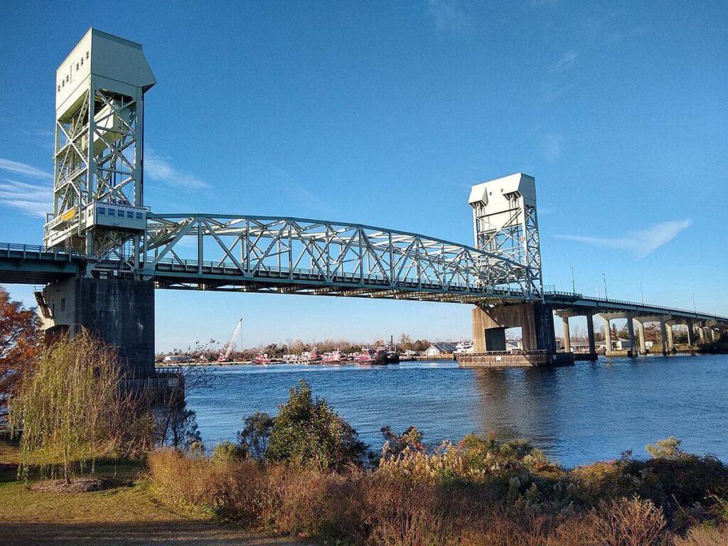
Bridge lanes to be closed for months during repairs
A preservation project, to extend the life of the Cape Fear Memorial Bridge, will temporarily close portions of the bridge in the coming months. Built in 1967, the Cape Fear Memorial Bridge is reaching the end of its lifecycle and must be monitored, inspected and maintained on a more frequent basis. Daily inspections of the steel vertical-lift bridge have shown the need to conduct longer-lasting improvements. The work scheduled to begin in early 2024 will repair the moveable bridge deck. Weather and material dependent, the eastbound lanes heading into Wilmington will close as early as Jan. 3. The westbound lanes will remain open to traffic. During this closure, those wanting to drive into Wilmington will detour to take the Isabel Holmes Bridge to Martin Luther King Jr. Boulevard to College Road. The bridge is scheduled to be open in both directions on April 1-7 for the North Carolina Azalea Festival in downtown Wilmington. Tentatively, on April 8, contract crews will close the westbound lanes to traffic and reopen before Memorial Day. The contractor, Southern Road & Bridge LLC, was awarded the $7.1 million contract on Nov. 30. The department has incentivized the company to finish early, potentially earning an extra $500,000. The N.C. Department of Transportation will continue to update the public as more information becomes available. For real-time travel information, visit DriveNC.gov or follow NCDOT on social media.
Read more » click here
Local officials, DOT squabble as Cape Fear Memorial Bridge lane closures loom
The DOT intends to close traffic in one direction over the Memorial Bridge for months at a time, starting as soon as early January, to allow much-needed repairs to the bridge’s moveable mid-section
Wilmington Mayor Bill Saffo was fuming. In early January, the N.C. Department of Transportation (DOT) intends to shut down both lanes of the Cape Fear Memorial Bridge carrying traffic from Brunswick County into Wilmington for several months. After reopening the bridge in both directions in early April for the N.C. Azalea Festival, the lanes into Brunswick County from the Port City will be closed until Memorial Day − roughly seven weeks. With the Memorial Bridge carrying more than 72,000 vehicles a day, the move means thousands of Brunswick County commuters and other drivers will have to find a new route to reach businesses, shops, medical facilities, family and friends on the New Hanover County side of the Cape Fear River. The mayor of Wilmington said only formally announcing the work Dec. 1 via a news release that the state intended to shut down lanes on the city’s main bridge crossing for an extended period was unacceptable. “I’m not sugarcoating it,” Saffo said recently. “This isn’t a problem created by local governments. This is a problem created by the state government, and they should have been at the table a lot earlier.”
‘Tough situation’
The need to replace the Memorial Bridge, which opened to traffic in 1969, has been a slow-moving crisis for decades that’s about to hit the front burner. While New Hanover and Brunswick officials for years and even decades have been unable to agree on many aspects of a new crossing, including where it should go and how it should be financed, the DOT has been crystal clear there isn’t enough money in the agency’s budget to build a new bridge and associated roadway infrastructure without outside funding sources − whether tolls, a local revenue source, a public-private partnership or federal help. But local officials, backed by many residents, have shown little appetite for tolls to replace a bridge that’s currently free to cross, and efforts to increase the region’s sales tax rate like Myrtle Beach and Charleston did to build new transportation infrastructure have gone nowhere. The DOT also has been vocal, especially in recent years, that the clock is ticking on how long they can keep the bridge operational as container truck traffic and overall traffic volumes continue to climb. But Saffo and other local officials have pushed back against the DOT, noting a lot of the wear and tear the state-owned bridge is seeing is due to the rapid growth the state-run Port of Wilmington has seen in recent years. They also point to projects in other parts of the state the DOT is constructing through traditional, non-tolling ways to deal with growth and congestion. “This is putting us in a really tough situation,” Saffo said, of the impending lane closures. “We’re trying to accommodate the port, the state, but also trying to protect the residents of those communities that are going to be impacted by this closure, and with all the impacts this is going to cause I feel strongly that we would have had a lot more discussion, outreach efforts on the DOT’s part than what we’ve seen.”
DOT: Local officials were aware
At a recent New Hanover County Board of Commissioners meeting, county officials raised similar concerns about a lack of communication from the DOT. Commissioner Jonathan Barfield called the state’s lack of public outreach a “dereliction of duty to our community,” while Commissioner Rob Zapple said he didn’t understand why the repair work was going to take so long when major infrastructure projects with significant impacts in other parts of the country get done in a much shorter time span then what’s being proposed with the bridge deck repairs. But DOT officials, who didn’t attend the commissioners’ meeting, have pushed back against the criticism. They’ve said the agency has made presentations about the upcoming project and the need for the work at several monthly meetings of the Wilmington Metropolitan Planning Organization (MPO), which is made up of elected officials from the region and helps guide transportation policy and priorities for the Cape Fear area. Several local media outlets, including the StarNews, also reported about the upcoming lane closures this summer and early fall. In response to questions about why both lanes in one direction need to be shut at a time, the DOT has said it’s the only way to replace the support beams for the bridge’s riding deck, since it requires removing part of the roadway. The riding deck is the open-grated steel deck in the middle of the Memorial Bridge that is raised to allow tall ships to pass under the span.
‘A bitter pill’
With no easy or fast solution and a lot of immediate traffic pain in sight, there are few easy answers for Wilmington and Brunswick County residents about to be consumed by gridlock. While acknowledging the failures of local officials in past years to agree on a plan forward and the DOT unable or unwilling to commit the funds necessary for a new bridge, state Rep. Deb Butler said it’s going to be a tough first few months in 2024. “This is one of those big, Herculean infrastructure projects that’s going to be disruptive,” said the Wilmington Democrat, whose district includes the city’s downtown area. “It is, it just is. If we want a new bridge, we better understand that all of us are going to be dissatisfied a little bit. It’s just a bitter pill we’re all going to have to swallow.” But Butler said she was confident that state and local officials will be able to navigate a path forward to building a replacement crossing. “I believe if Charleston (South Carolina) and Savannah (Georgia) can do it, we can do it,” she said, referring to two Southern coastal towns like Wilmington that have built new downtown bridge crossings in recent decades. “I firmly believe that in my heart.” While a new replacement Memorial Bridge might still be years off, there’s at least one piece of good news. The DOT’s $7.1 million contract for the deck-replacement work includes significant financial rewards for the contractor to get the work done early. A similar incentive offer helped get the new high-rise bridge in Surf City, which opened in 2018, completed 10 months ahead of schedule. Staffers with the DOT and several local governments, including Wilmington and New Hanover and Brunswick counties, also intend to meet weekly, starting Tuesday, to flush out emergency response, public communication efforts and other plans for when the bridge lanes are closed. At the recent commissioners’ meeting, County Manager Chris Coudriet also said that while Jan. 3, 2024, was the first day the contractor could start work, DOT officials have said that didn’t necessarily mean that’s when the lane closures would take place. “What was made very clear around the table by city and both county staffs is we need plenty of advance notice if it’s not going to be Jan. 3, what date is it so that we can communicate and prepare our communities,” he told the commissioners.
Read more » click here
‘Quite the mess:’ Cape Fear Memorial Bridge lane closures to impact local businesses, employees
More than 60,000 vehicles cross the Cape Fear Memorial Bridge each day according to the North Carolina Department of Transportation. Starting as soon as Jan. 3, both lanes on the bridge heading into Wilmington will close so crews can make repairs to the moveable deck. After those repairs are complete, NCDOT officials say those lanes will reopen, and the lanes into Brunswick County will close. The repairs could last until Memorial Day. Wilmington Urban Area Metropolitan Planning Organization Deputy Director Abby Lorenzo says the organization has been working with local businesses to prepare for the upcoming traffic. NCDOT officials expect traffic to be detoured across the Isabel Holmes Bridge and I-140. While this is sure to cause delays, Lorenzo says the best way to limit headaches is to reduce the number of cars on the road. “If you have the ability to shift when you’re out on the road traveling if you have the opportunity to go with your neighbors to the grocery store or whatever trip you may have planned, those are all eating and removing those vehicle miles traveled,” Lorenzo said. Lorenzo says WMPO’s Go Coast program can help people understand how to use alternate forms of transportation to get where they need to go. “Every trip saved, even if it seems like a minimal low impact, it is helping,” said Lorenzo. “[But] it’s not going to mitigate all the congestion we’re going to see.” Laurie Anderson is a teacher who lives in Leland but works in New Hanover County. She says she is already planning to leave an hour earlier than usual to get to work once the repair work begins. “I am going to try starting an hour early to get to just the other side of the Cape Fear Bridge which is normally about 12 [minutes]. I’ll start at 6 a.m. but if there’s an accident who knows what will happen,” Anderson said. The lane closures and inevitable traffic are also likely to impact businesses on both sides of the bridge. While Lorenzo and WMPO officials have suggested remote work as an option to reduce traffic, that is not an option for Anderson or Waterline Brewing Company Owner Rob Robinson. Robinson says the repair work will impact his business- and others nearby- in more ways than one. “I think that the bridge closure is going to have kind of a subtle effect, not just the overt effect,” said Robinson. “It’s going to create traffic problems in the drive across for the businesses like us that do deliveries, but I think it’s also going to impact the number of people that might just stay home instead of going out.” NCDOT Engineer Chad Kimes says the bridge repairs need to be done before the summer to avoid the possibility of having to shut the entire bridge down. Robinson, meanwhile, hopes that the repairs will not make the slow season even slower. “We get a lot of people that come to visit us and the rest of downtown from Brunswick County and from Leland and they come across the bridge and so, going all the way around to Isabel Holmes is going to be quite the mess,” Robinson said. NCDOT awarded a $7.1 million contract to Southern Road & Bridge LLC for the project. The company can earn an additional $500,000 if the project is finished early.
Read more » click here
This and That –
Survey open regarding Brunswick County libraries

Officials are asking for feedback from library goers in Brunswick County. A survey is open to gauge ways library services can be improved in the county. It takes 5 to 10 minutes to complete and is open here through Dec. 31, 2023. Paper copies are available at all five library branch locations as well. Anyone who uses the library — regardless of local residency — can participate. This includes visitors who work, shop, or conduct business and participate in activities in Brunswick County.
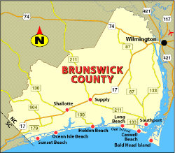 How Brunswick County’s ‘migration story’ has fueled record economic growth
Brunswick County’s continued population growth is fueling its economy, according to one of the region’s top economic experts. Mouhcine Guettabi, regional economist in Wilmington, presented an economic snapshot to the Leland Town Council at its November meeting. Guettabi, who is also an associate professor of economics at the University of North Carolina Wilmington, said migration to Brunswick County and the region is contributing to the area’s economy. “One of the fascinating things that everybody here knows is that the region has experienced incredible migration over the last couple of years,” Guettabi said. Between 2020 and 2022, Brunswick County grew at a rate of 12% — faster than any other county in the state. Both Pender and New Hanover counties are behind that rate at 9% and 4%, respectively, but Guettabi said the region as a whole has been growing “incredibly fast.” The growth – and with it, the income injection – is largely contributed to migration of residents from other counties in the state as well as from the northeastern United States. According to Guettabi, taking the gross income of those that have moved into the tri-county region (Brunswick, New Hanover and Pender counties) and removing the income of those who have left figures that an estimated $1 billion of income was injected into the local economy between 2020 and 2021. “It’s a migration story,” Guettabi said. “…If you were to remove migration from the equation, Brunswick County, New Hanover and Pender would have actually shrunk.” Deaths, he said, have outnumbered births in the region in recent years, so “absent migration, the whole region would have actually shrunk.”
‘Mind-blowing’ figures
Data from the Internal Revenue Service estimates that – as a direct result of this migration – millions of dollars was injected into the local economy between 2020 and 2021. The largest figure, again, goes to Brunswick County, which saw $548 million in net income change – the highest figure in the state. Nearby New Hanover County saw an additional $280 million in net income change from migration and Pender County saw an additional $110 million.
Labor market
Guettabi said employment in Brunswick County has also been growing rapidly, with private, federal, local and state sectors seeing “significant growth” since 2019. In the county, he said, there are about 16% more wage and salary jobs in 2023 than there were in 2019. The accommodation and food services industry saw the greatest increase in jobs, he said, largely responding to the growth in population. Average weekly wages have also grown since 2019, he said, in all four sectors. While the labor market “held up remarkably well” through the pandemic years, Guettabi said it’s likely the region will see a decrease in job growth for the first time since 2020 in the approaching new year.
What’s next?
While a recession has been forecast over recent years, it hasn’t happened. Guettabi said data – foggy as it may be – indicates, however, that consumer spending may be “running out of runway.” Consumers, he said, largely saved money during the pandemic, but are nearing the bottom of their barrels. Inflation and wages, both of which have gone up regionally in recent years, are both moderating recently, he added. Housing markets in Brunswick and New Hanover counties, Guettabi said, are still seeing all-time highs in home prices. Locally and nationally, he said, experts are wondering who will blink first – buyers or sellers.
Read more » click here
Factoid That May Interest Only Me –
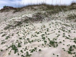
 Christmas Trees Recycling
Christmas trees can be recycled to help build sand dunes on the beach. It is a way to build more protection on the shore by using them as a natural and biodegradable sand fencing. The trees are positioned facing downward at a 45-degree angle. Once the trees are laid down, they are left completely exposed except for the tips, which are covered in sand. The needles of the branches catch the sand, and it starts to accumulate until gradually the sand will bury the tree and build up the dunes around them. As the tree biodegrades, it provides nutrients to the other plants and organisms around it.
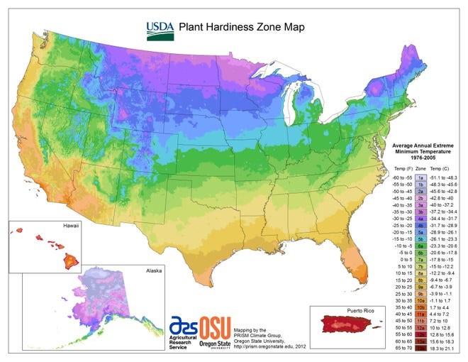 New plant hardiness zone map to help NC gardeners, farmers keep pace with climate change
The new map gives guidance to growers and farmers about which plants, shrubs and vegetables are most likely to thrive in a particular region as temperatures keep increasing
Last month, there was big news in the plant world, and while it shows the weather has been warming in recent years in Southeastern North Carolina, you might just want to wait a few decades before planting your outdoor pineapple and banana trees. If you have ever tested your green thumb, you’ve probably taken at least a quick look at the U.S. Department of Agriculture’s USDA plant hardiness zone map. The color-coded map, which covers the entire country, is based on the average annual extreme minimum temperature recorded in a region. It doesn’t signify the coldest an area, say Pender County, has ever gotten, but rather the average lowest winter temperatures over a 30-year period. The zone categories are useful for both homeowners and farmers to know generally how to make the best plant and crop selections for gardens, nurseries and fields, since low temperatures during the winter are crucial factors in the survival of plants at specific locations. Last month, the USDA released a new hardiness map, which is updated every decade. Along with offering more bells and whistles that allow folks to just type in an address to see their new zone designation, it also uses data from more than 13,600 weather stations for greater accuracy. That compares to the fewer than 8,000 stations used for the 2012 map, according to the USDA. The new 2023 map also is divided into 10-degree Fahrenheit zones and further divided into 5-degree Fahrenheit half-zones, to reflect microclimates and the inclusion of more weather data. When compared to the 2012 map, the 2023 version reveals that about half of the country shifted to the next warmer half zone, and the other half of the country remained in the same half zone. “These national differences in zonal boundaries are mostly a result of incorporating temperature data from a more recent time period,” according to a USDA release.
What does it mean for Southeastern N.C.?
Most of the Wilmington area has now moved from being classified as Zone 8a to now falling into Zone 8b, which shows the average low temperatures run from 15-20 degrees. Parts of inland Pender County are still in Zone 8a, which shows winter lows can dip to 10-15 degrees. The change in hardiness zones means that plants that were once on the fringes of growing in our area could perhaps perform better or worse due to shifting weather patterns and climate. Certain crops and other vegetables also might now be able to be planted earlier since the spring warm-up will come sooner on the calendar. But do the new zone designations also reflect climate change? Federal officials said while climate change likely played a role in the warming trend, other factors also are reflected in the new zone designations. “Temperature updates to plant hardiness zones are not necessarily reflective of global climate change because of the highly variable nature of the extreme minimum temperature of the year, as well as the use of increasingly sophisticated mapping methods and the inclusion of data from more weather stations,” states the USDA release. “Consequently, map developers involved in the project cautioned against attributing temperature updates made to some zones as reliable and accurate indicators of global climate change (which is usually based on trends in overall average temperatures recorded over long time periods).” Along with the USDA, the new hardiness maps were developed with help from Oregon State University’s PRISM Climate Group. Still, there’s plenty of evidence to show man’s pumping of greenhouse gasses into the atmosphere is helping to accelerate any natural warming that’s taking place. The European Union’s Copernicus Climate Change Service announced that the world saw its warmest-ever November last month, roughly 1.75 degrees Celsius (3.15 degrees Fahrenheit) warmer than the pre-industrial average. For January to November 2023, the service said global average temperatures were the highest on record − 1.46 degrees Celsius above the pre-industrial average. That means 2023 will be the hottest year ever recorded. Climatologists have said global temperatures this century need to stay under 1.5 degrees Celsius (2.7 degrees Fahrenheit) warmer than pre-industrial levels to prevent irreversible damage to the world’s environment. In North Carolina, most of the hottest years on record have been recorded in the past decade, with 2019 North Carolina’s warmest year in 125 years of record keeping.
Read more » click here
Hot Button Issues –
Subjects that are important to people and about which they have strong opinions

Climate
For more information » click here
.
There’s something happening here
What it is ain’t exactly clear

Flood Insurance Program
For more information » click here

National Flood Insurance Program: Reauthorization
Congress must periodically renew the NFIP’s statutory authority to operate. On November 17, 2023, the President signed legislation passed by Congress that extends the National Flood Insurance Program’s (NFIP’s) authorization to February 2, 2024.
Congress must now reauthorize the NFIP
by no later than 11:59 pm on February 2, 2024.
The Flood Insurance Program is Sinking:
The actual words of David Maurstad, the federal official in charge of the Nation Flood Insurance Program, were “the NFIP is not fiscally sustainable in its present form” when he spoke with reporters in late October. That may not be a surprise, but what hasn’t generally been reported is the wholesale reform package that the Biden administration has proposed to Congress.
First, some background. With more than 4.7 million policies, FEMA has borrowed over $20 billion to stay afloat and nearly ran out of money in September. Even with the much-maligned Risk Rating 2.0 NFIP premium increases, the program is struggling to deal with hurricanes and fires at a time when those disasters might be fewer in number but are increasing in cost. Given that background, the Biden administration has sent Congress no less than 17 proposals to overhaul the NFIP.
Here’s a short list of some of the most important points of this package –
- Requires communities participating in the NFIP risk reduction plan to establish minimum flood-risk reporting requirements for residential sellers and lessors.
- Allows for the use of replacement cost value in determining premium rates to “more accurately signal policyholders’ true risk.”
- Creates separate classes for coastal versus inland flood zones in the NFIP’s rate tables.
- Provides a means-tested assistance program for offering a graduated discount benefit for low- and moderate-income households.
- Prohibits coverage for new construction in high-risk areas and prohibits [presumably new] coverage for all commercial properties “to promote the growth of the private market….”
- Prohibits coverage for “excessive loss properties” or properties that flood repetitively and require insurance payouts of at least $10,000 each time.
These are obviously major changes, and there are more we haven’t listed. Congress has shown little interest in tackling NFIP reform, preferring to kicking the can down the road with two dozen extensions of the existing program. That means these proposals may be dead in the water. However, having to forgive over $20 billion in outstanding debt to the Treasury (which will happen next year or very soon after) plus inevitably needing to provide more billions to enable the program to stay afloat may be just the impetus Congress needs to face reality.
To be clear on why the can keeps getting kicked, there is no doubt that members of congress recognize the problem with the program – premiums are too low and do not reflect actual risk exposure carried by the program. Yet these same members are essentially held hostage by their voter bases to ensure NFIP premiums stay low. Because constituents simply do not want to pay more, supporting more expensive premiums (which reflect actual risk) puts members’ re-election on the line.
WATERLOG – November Newsletter

GenX
For more information » click here
EPA pulls plug on previously approved GenX imports
The U.S. Environmental Protection Agency has reversed its approval for Chemours to import GenX into North Carolina. The agency announced its decision today, prompting quick responses from both state officials and the company. “It’s good that the EPA reversed this decision and I’m grateful for their quick response,” Gov. Roy Cooper said in a statement. “We have been working for years in North Carolina to force the cleanup of forever chemicals to help ensure clean water, and companies like Chemours have made this effort more difficult.” Chemours in a release this afternoon said it does not discharge GenX into the Cape Fear River through its recycling process at its Fayetteville Works facility in Bladen County and that a “calculation error” had incorrectly identified the amount the company wants to import. “Our reclamation and recycling process for [GenX] is circular and more environmentally friendly than manufacturing larger quantities of new compound,” the release states. “We identified and acknowledged a calculation error in the applications to the Dutch ILT that we proactively disclosed to US regulators. The amount being imported is in fact far below the levels approved by EPA in the original permit. We are working to correct the information and will continue to engage with authorities on the path forward.” The EPA’s decision in October to sign off on Chemours importing as much as 4 million pounds of GenX from its plant in the Netherlands sparked outrage from state and local officials. GenX is one of thousands of manmade chemicals known as per- and polyfluoroalkyl substances, or PFAS, and is specific to Chemours’ Fayetteville Works plant. Chemours is under a Consent Order with the North Carolina Department of Environmental Quality and the nonprofit Cape Fear River Watch to drastically reduce the amount of PFAS it discharges into the environment, including the Cape Fear River, which is the drinking water source for tens of thousands of people. The company is also being held responsible for PFAS contamination in private wells throughout the Cape Fear region, which includes at least eight counties. The EPA made its decision to reverse course based on information provided by DEQ, according to a department release. “We appreciate that the EPA heard the concerns shared by the Governor and the residents directly affected by PFAS contamination from Chemours,” NCDEQ Secretary Elizabeth Biser said in a statement. “North Carolina is committed to reducing PFAS pollution and today’s reversal aligns with that goal.” The company stated that it had invested hundreds of millions of dollars in emissions controls at its Fayetteville plant. “Chemours responsibly manufactures critical products that support national and Biden Administration priorities like American manufacturing of semiconductors and decarbonizing the energy sector. Our products and our actions promote a more sustainable future, and we will continue to deliver on our commitment to reduce our environmental footprint.” In September, experts appointed to the United Nations sent letters to Chemours, Corteva and DuPont de Nemours criticizing their use of PFAS. Those UN experts said the companies likely violated the human rights of residents in the Cape Fear region. Letters were also sent to the governments of the Netherlands and the United States accusing regulators of failing to protect human health and the environment.
Read more » click here
EPA reverses approval of GenX waste importation after DEQ found inaccurate information
The Environmental Protection Agency announced Wednesday the reversal of its authorization for Chemours to import millions of pounds of GenX waste. It sent a letter to Gov. Roy Cooper, who expressed his disapproval of the EPA’s decision earlier this month. In the Nov. 29 letter to Gov. Cooper, EPA administrator Michael Regan noted the reversal was influenced by the North Carolina Department of Environmental Quality’s finding Chemours did not provide accurate information about export volume requested and the amount of GenX waste its Fayetteville facility could process. Regan wrote it was “different from a factor of ten from the amount the company had initially quoted” in its notification approved by the EPA. “Because information in both notifications was incorrect, the September 8, 2023 consents to the import of waste from the Netherlands into the United States are no longer valid,” Regan wrote. In a statement on the decision Wednesday, Chemours insisted its calculation error was “proactively disclosed to US regulators” and said the imported waste would be far below the amount approved in the initial permit. Chemours said its importation of GenX waste would be used for recycling; it argued this is more environmentally friendly than manufacturing new compounds. It claimed the recycled PFAS waste would not be discharged in the Cape Fear River. The Sept. 8 EPA decision permitted Chemours to import more than 4 million pounds of GenX waste for recycle and reuse from the company’s Dordrecht, Netherlands facility, which is under criminal investigation. The waste would have been shipped to Chemours Fayetteville Works plant in Bladen County, North Carolina. The import was halted after public outcry and letters were sent to the EPA from Gov. Cooper, as well as local leaders from New Hanover and Brunswick counties. Gov. Cooper issued a statement Wednesday commending the new EPA decision. “It’s good that the EPA reversed this decision and I’m grateful for their quick response,” Cooper said in a statement Wednesday. “We have been working for years in North Carolina to force the cleanup of forever chemicals to help ensure clean water, and companies like Chemours have made this effort more difficult.” The New Hanover Board of Commissioners similarly released a joint statement: “This development is a significant victory for the environmental health and safety of New Hanover County and the Cape Fear River. We commend the EPA and NCDEQ for their diligent efforts and collaboration in making this critical decision, reflecting our shared commitment to protect our community.” North Carolina Senator Thom Tillis also released a statement Wednesday celebrating the EPA’s reversal. “It is vital all North Carolinians have access to safe water, and I’ll continue my work to address the risks posed by emerging PFAS contaminants, just like we did with the historic clean water investment in the Bipartisan Infrastructure Law,” he said.
Read more » click here

Homeowners Insurance
For more information » click here
.

Hurricane Season
For more information » click here
Hurricanes have always struck the shores of the United States. But in recent decades, the combination of climate change and growing coastal population has made them far more damaging – particularly in one corner of the Atlantic coast. Roughly 150 Atlantic hurricanes have approached or directly hit the United States in the last seven decades. Gulf Coast regions like coastal Louisiana and Florida frequently encounter powerful hurricanes, of course. But some of the most hurricane-prone parts of the country lie further northeast, on the Carolina coast. Between 2016 and 2022, the Carolinas were hit by five hurricanes: Matthew, Florence, Dorian, Isaias and Ian. At the crossroads of these hurricanes lie the metro areas of Myrtle Beach, S.C., and Wilmington, N.C. These two metros, known for their striking coastlines, have been regularly battered by hurricanes this century. They also have something else in common: Both are among the fastest-growing coastal metros in the United States since 2000. Why do so many people decide to move here despite the risks? And what does that mean for everyone else?
A Beautiful Place That Has a Dragon’:
Where Hurricane Risk Meets Booming Growth
The hurricanes keep coming, and the people, too: The fastest-growing places along the Atlantic coast this century are also among the most hurricane-prone. Between 2016 and 2022, the five hurricanes that hit the Carolinas cost the two states over $33 billion in damages in current dollars, displaced hundreds of thousands of people and led to the deaths of more than 90. There’s every reason to expect more damage in coming years: A warming climate adds moisture to the air, unlocking the potential for wetter and more powerful storms. And rising sea levels make storm surges more damaging and coastal flooding more frequent. And the newcomers will keep coming: One 2022 study projected that by 2050, population growth will increase the number of Americans exposed to flooding nearly four times as much as climate change will alone. Simply put, there are many more people living along the paths of hurricanes than ever before. And this booming coastal population is, by many accounts, a larger contributor to rising hurricane risks than climate change. “It’s always climate change plus something, and we’re moving more people into harm’s way than out,” said Kathie Dello, North Carolina’s state climatologist. Local officials say they are struggling to keep up with the growth. They can try to manage the floodplain, communicate the risks, regulate construction and prepare for disasters. But the one thing they can’t seem to do is stop people from moving here. Many retirees are drawn to the Carolinas’ beaches and waterways, moderate temperatures and low taxes. Between 1990 and 2020, the number of people 65 and older grew by nearly 450 percent combined in Horry County, S.C., and adjoining Brunswick County, N.C. When Gail Hart moved from Arizona to retire in Wilmington, N.C., in 2017, she hadn’t considered the hurricane risk. “I wanted to be near a beach,” she said. “I wanted a community.” The next year, Hurricane Florence made landfall in the Wilmington metro area. Many neighborhoods flooded. In some places, three feet of water entered homes. Emergency officials rescued over a thousand residents. Ms. Hart evacuated. She was fortunate: Her home suffered only minor wind damage. But the experience changed her view of living there. She installed storm shutters and a generator and bought flood insurance. And yet, like so many others, she has stayed despite the storm risks. “I don’t let it affect my life unless there’s a hurricane coming,” she said. Ms. Hart is far from alone. When she arrived, there were about a dozen homes in her retirement community. Today there are over 500. In a retirement community being built across the road, acres of pine forests have been cleared to develop homes along the Cape Fear River. Nearby, marshland with ghost forests of dead trees was up for sale as “riverfront condo land.” Wilmington is part of New Hanover County, the most densely populated of the state’s coastal counties. Nearly 40 percent of its homes risk being severely affected by flooding in the next 30 years, according to the First Street Foundation. “There’s just not a lot of area left,” said Steven Still, director of emergency services for the county. “So, you’re developing in the fringe areas.” The escalating costs of storms raise a difficult question for these growing coastal communities: How do you balance growth with safety? The combination of climate change and development in risky areas is making it “a huge challenge” to keep residents safe, said Amanda Martin, North Carolina’s chief resilience officer. It’s not just that people are moving to hurricane-prone areas. The growth itself can make flooding worse. Cutting down trees and paving over wetlands takes away open land that would otherwise absorb rainfall. “We just seem to be going through this vicious cycle that is becoming more vicious with the amount of people and infrastructure we put in these areas,” Mr. Still said. Federal law permits people to build in flood zones, so long as they meet certain minimum standards. In return, the government offers them flood insurance through a federal program that is over $20 billion in debt — largely due to escalating hurricane damages. While the National Flood Insurance Program was originally intended to discourage floodplain development, in practice it has done the opposite by removing a lot of the financial risk involved, said Jenny Brennan, a climate analyst at the Southern Environmental Law Center. States have a few options to discourage people from building in flood zones. They can create more stringent building requirements, or they can buy up and preserve undeveloped land. But these measures are expensive and rely on political will or the willingness of landowners to sell. One way that states can move residents out of harm’s way is by offering to buy out their homes and permanently converting that land to open space. But a study this year found that for every home bought out in North Carolina between 1996 and 2017, more than 10 new ones were built in the state’s floodplains. The growth also makes it more difficult to evacuate when storms strike. In these booming coastal counties, residents and local officials say that roads and bridges are not keeping pace with the growth. “Our biggest problem is our infrastructures not being able to keep up,” said David McIntire, the deputy director of emergency management for Brunswick County, the fastest-growing coastal county in North Carolina this century and part of the Wilmington metro. The state has undertaken a multiyear project to add two lanes to Highway 211, the main evacuation route for the region. Mr. McIntire said the state and local departments were “having to play catch-up” after years of failing to plan ahead. In neighboring New Hanover County, his counterpart Mr. Still is grappling with a shortage of affordable housing, which he said was making it “exponentially difficult” to shelter people displaced by disasters. After a disaster, the surge in demand for short-term housing drives up already high rents. Poorer residents often rely on the state and local governments for assistance with evacuation and housing. The problem lies in where to house them. “If there is zero housing availability in the community right now,” Mr. Still said, “where do you put 100,000 people?” The housing crunch is one of many tensions playing out between wealthy coastal communities and those who live nearby. April O’Leary lives in Conway, S.C., an inland city in Horry County, a half-hour drive from Myrtle Beach. The county makes up the Myrtle Beach metro area, which was the fastest-growing coastal metro nationally between 2000 and 2020 and is one of the fastest-growing places in the country annually. And the growth is projected to continue. Horry County is large and flat: Nearly a quarter of its land lies within a floodplain. After Hurricane Florence made landfall, it took about a week for the rainwater to flow down to Conway. But the water stayed for over a week. “It sits for a while and it just destroys everything,” Ms. O’Leary said. Water entered her home, flooding the first floor and a bedroom. Her husband and son evacuated to Myrtle Beach, while she stayed for a few days to document the floods. Afterward, there were large piles of debris lining street after street in her neighborhood, filled with ruined flooring, kitchen cabinets and bathroom fixtures. When her son’s elementary school reopened and he saw the devastation in the neighborhood, she said he stopped smiling and became quieter for months. After the flooding, Ms. O’Leary founded Horry County Rising, a political organization that campaigned for the county to adopt stricter regulations for floodplain construction. Much of the flooding in the Carolinas during Hurricane Florence occurred outside of federal flood zones, where few people have flood insurance or homes that are protected from flooding. In 2021, the county expanded its flood zone boundaries to include places that flooded during Hurricane Florence. And it required new homes built there to have their lowest floor three feet above the high water mark. The changes applied to all unincorporated parts of the county. But they faced pushback from local developers because of raised building costs. The county recently voted to lower the height requirements to two feet, after legal pressure from a developer. The flooding and growth also affect rural communities that have been rooted in the Carolinas for generations. In Bucksport, S.C., a small inland town in Horry County, Kevin Mishoe is a third-generation farmer and former chair of the Association for the Betterment of Bucksport. He said the newer building codes would pay dividends in future floods, but they would also make home ownership far more expensive for people in lower-income communities like Bucksport. Bucksport sits between two major rivers, nestled against wetlands and tidal forests. Mr. Mishoe lives with his wife in a mobile home that flooded during Hurricane Matthew in 2016 and Hurricane Florence in 2018. Mr. Mishoe says he believes banks are denying loans to residents because of their location in a floodplain, a phenomenon he called “bluelining.” Meanwhile, he said, locals are being “bombarded” with offers from developers and private equity companies to buy their land. “All of a sudden land that you’re telling us is almost worthless because you’re in a flood zone, everybody’s trying to buy,” he said. The area is considered prime real estate because of its access to water. This year, the county expressed support for a highway that would connect Myrtle Beach to inland parts of the county. The highway is expected to cut through Bucksport and its adjoining wetlands and bring added development to the region. The town’s residents emphatically do not want to sell their land, Mr. Mishoe said. Their ancestors have held on to this land for generations, and they intend to stay. Bucksport’s flooding problem began in 2015. But there are coastal Carolina communities that have endured regular hurricanes for over a century. Karen Willis Amspacher lives on Harkers Island in Carteret County, N.C. — one of the most hurricane-prone counties in the country. The island is part of a string of low-lying rural communities near the Outer Banks that locals call Down East. The communities are connected by Highway 70, a dredged road that floods several times a year. Ms. Amspacher is a fifth-generation resident of the island and the director of the Core Sound Waterfowl Museum. There are a lot of newer residents, she said, moving into large houses on stilts, with generators and flood insurance. Some houses are second homes or vacation properties. The construction boom has driven up costs for locals. “The fear and threat of sea level rise or storms doesn’t hinder any of it,” she said. While the new homes may be safer, Ms. Amspacher said, many of the newcomers are isolated from the emotional trauma that her community experiences during a hurricane. “This is a piece of property to them,” she said. “It’s not their family inheritance. It’s not their home. It’s not where they hope their children will stay and grow up.” Ms. Amspacher has had to evacuate her home in three past hurricanes. But she’s not planning to leave for the next one. She said staying during storms was a way to protect property from damage and was part of her community’s cultural identity. “These hurricanes make these communities what we are,” she said. Back in Wilmington, Sharon Valentine is also no stranger to hurricanes. She owned a large animal farm near Fayetteville, N.C., which was devastated by Hurricane Fran in 1996. So, when she and her partner decided to retire in Wilmington’s Del Webb community in 2017, they knew the risks. Many others have followed since. “There’s a mass migration down here,” she said. Ms. Valentine organizes annual hurricane training for these newer arrivals. The community members have evacuation plans and look out for one another. She, too, said the local infrastructure hadn’t kept up with growth. There are two small bridges on either end of River Road that serve as the main evacuation routes for her community. She is concerned that they may flood in a major storm. “If we really ever have a bad one, we’re going to have to get out of here,” Ms. Valentine said. Still, when she thinks about all the newcomers, she sympathizes with their reasons for moving here. “It is a beautiful place that has a dragon emerge periodically,” she said. “And so, you weigh your risks.”
Read more » click here
2023 Atlantic hurricane season ranks 4th for most-named storms in a year
NOAA advances modeling and observation capabilities during the season
The above-normal 2023 Atlantic hurricane season, which officially ends on Nov. 30, was characterized by record-warm Atlantic sea surface temperatures and a strong El Nino. The Atlantic basin saw 20 named storms in 2023, which ranks fourth for the most-named storms in a year since 1950. Seven storms were hurricanes and three intensified to major hurricanes. An average season has 14 named storms, seven hurricanes and three major hurricanes. Hurricane Idalia was the only U.S. landfalling hurricane in 2023. It made landfall as a category-3 hurricane on Aug. 30 near Keaton Beach, Florida, causing storm surge inundation of 7 to 12 feet and widespread rainfall flooding in Florida and throughout the southeast. Tropical Storm Ophelia made landfall as a strong tropical storm with 70 mph winds on Emerald Isle, North Carolina, on Sept. 23 causing widespread heavy rainfall, gusty winds and significant river and storm surge flooding in portions of eastern North Carolina. Hurricane Lee made landfall as a post-tropical cyclone in Nova Scotia, Canada, on Sept. 16. Swells generated by Lee caused dangerous surf and rip currents along the entire U.S. Atlantic coast. Strong winds with hurricane‑force gusts from Lee caused extensive power outages in Maine and in parts of Canada. The 2023 Atlantic seasonal activity fell within the NOAA Climate Prediction Center’s predicted ranges for named storms and hurricanes in the August updated outlook. “The Atlantic basin produced the most named storms of any El Nino influenced year in the modern record,” said Matthew Rosencrans, lead hurricane forecaster at NOAA’s Climate Prediction Center — a division of NOAA’s National Weather Service. “The record-warm ocean temperatures in the Atlantic provided a strong counterbalance to the traditional El Nino impacts.” The eastern Pacific basin hurricane season was also above normal with 17 named storms, of which 10 were hurricanes and eight of those major hurricanes. From Aug. 16 to 21, Tropical Storm Hilary brought widespread heavy rainfall and flooding to Southern California, with some areas receiving up to 600% of their normal August rainfall. Hilary resulted in the first ever issuance of Tropical Storm Watches and Warnings for the Southern California coastline by NOAA’s National Hurricane Center. In addition, the Center distributed key hazard focused messages for Hilary in Spanish through the agency’s new language translation project. Hurricane Otis made landfall near Acapulco, Mexico, on Oct. 25 as a category-5 hurricane with sustained winds of 165 mph. Otis holds the record as the strongest landfalling hurricane in the eastern Pacific after undergoing rapid intensification in which wind speeds increased by 115 mph in 24 hours. The central Pacific basin had a near-normal season with four tropical systems traversing the basin. Hurricane Dora, a category-4 storm, passed south of Hawaii in early August, marking the first major hurricane in the central Pacific basin since 2020. The strong gradient between a high pressure system to the north and Dora to the south was a contributing factor to the wind-driven, fast-moving wildfires in Hawaii. Hurricane season activity for the eastern Pacific and central Pacific fell within predicted ranges. “Another active hurricane season comes to a close where hazards from the storms extended well inland from the landfall location,” said NOAA National Hurricane Center Director Michael Brennan, Ph.D. “This underscores the importance of having a plan to stay safe whether you’re at the coast or inland.” NOAA’s new Hurricane Analysis and Forecast System helped National Hurricane Center forecasters improve intensity predictions this season. NOAA’s intensity forecasts showed Hurricane Idalia as a major hurricane impacting the coast of Florida as early as Aug. 28. This lead time gave those in threatened areas more time to prepare and respond, and there were no storm surge fatalities from Idalia despite storm surge inundation of as much as 12 feet above ground level in some areas. Further, extending the National Hurricane Center’s tropical weather outlook product from five to seven days, this season provided emergency managers more time to prepare and stage resources before a storm.
NOAA’s hurricane research and response
This season, NOAA Hurricane Hunter aircraft flew 468 mission hours to collect atmospheric data that is critical to hurricane forecasting and research, passing through the eye of a hurricane 120 times and deploying over 1,400 scientific instruments. Since 2020 through this 2023 season, NOAA’s two Lockheed WP-3D Orion have flown 40% more hurricane mission flights than the preceding four years (2016-2019). NOAA celebrated the first operational launch of a Black Swift drone from a NOAA WP-3D Orion to gather atmospheric data in and around Hurricane Tammy. Further, the first successful coordination of a low-flying drone (Anduril’s Altius 600), atmospheric profilers (dropsondes), and ocean profilers (bathythermographs) also launched from a NOAA WP-3D Orion. Observations and information from these deployments are being evaluated to determine the feasibility of using the data to help with hurricane forecasting in the future. NOAA’s Beechcraft King Air flew 28 mission hours to collect aerial imagery used for emergency response after Hurricanes Idalia and Lee. Following Hurricane Idalia, NOAA’s National Ocean Service provided support to enable safe maritime navigation, gathering survey data for 36.8 linear nautical miles and identifying 29 potential obstructions along Florida’s coastal waterways. NOAA also worked to identify hazards caused by capsized vessels, damaged docks and piers, parts of homes and other types of marine debris, and shared findings with Florida’s debris task force following Hurricane Idalia. NOAA’s geostationary and polar-orbiting weather satellites provided vital information for monitoring and forecasting the hurricanes and tropical weather that threatened our lives and property this season. Forecasters used one-minute geostationary satellite imagery to assess structure changes during the rapid intensity of storms such as Idalia, Lee and Otis. NOAA’s polar-orbiting satellites orbit the Earth from pole to pole 14 times a day, providing full global coverage twice daily. Throughout the hurricane season, these satellites made sophisticated and precise observations of the atmosphere, ocean and land, which were critical to developing daily and 3-5 day forecasts. The National Hurricane Center and Central Pacific Hurricane Center Tropical Cyclone Reports for 2023, including synoptic history, meteorological statistics, casualties and damages, and the post-analysis best track, will be published on the 2023 Tropical Cyclone Report site in March 2024. NOAA’s Climate Prediction Center, a division of the National Weather Service, will issue its 2024 hurricane seasonal outlook in May 2024. The hurricane season officially begins on June 1.
Read more » click here

Inlet Hazard Areas
For more information » click here
.
Lockwood Folly Inlet
For more information » click here.

Seismic Testing / Offshore Drilling
For more information » click here.

Offshore Wind Farms
For more information » click here
Things I Think I Think –
 Eating out is one of the great little joys of life.
Restaurant Review:
The Dinner Club visits a new restaurant once a month. Ratings reflect the reviewer’s reaction to food, ambience and service, with price taken into consideration.
///// September 2023
Name: Island Way
Cuisine: American
Location: 1407 E Beach Drive, Oak Island, NC
Contact: 910.278.7770 / https://www.islandwayres.com
Food: Average / Very Good / Excellent / Exceptional
Service: Efficient / Proficient / Professional / Expert
Ambience: Drab / Plain / Distinct / Elegant
Cost: Inexpensive <=20 / Moderate <=26 / Expensive <=35 / Exorbitant <=60
Rating: Three Stars
/////
Island Way is a popular casual upscale beachfront restaurant with fantastic views of the ocean and pier. Its beach dining in style, with both indoor and outdoor dining options. This is one of the better restaurant offerings in the area, that is far better than most. I was quite impressed; what a pleasant surprise! It’s a busy place, that is filled to capacity nearly every evening. So, be cautious about making dining plans there during prime tourist season. If you want to eat there you probably should call ahead for reservations.
The 20 Best Restaurants in Wilmington, North Carolina
Book Review:
Read several books from The New York Times best sellers fiction list monthly
Selection represents this month’s pick of the litter
 ZERO DAYS by Ruth Ware
This thriller centers on a woman devastated by her husband’s murder and her emergence as the primary suspect. Jacintha “Jack” and her husband Gabe are skilled penetration tester specialists, experts hired by companies to hack into their security systems and find vulnerabilities. Once she realizes that she’s under suspicion for the murder of her husband she goes on the run. Jack will stop at nothing to identify who’s behind the killing and why. She’s in a race against time to clear her name and find her husband’s murderer. If that sounds familiar that’s because it is following a similar plot to the character Dr. Richard Kimble in The Fugitive.
That’s it for this newsletter
See you next month
Lou’s Views . HBPOIN
. • Gather and disseminate information
. • Identify the issues and determine how they affect you
. • Act as a watchdog
. • Grass roots monthly newsletter since 2008