
Lou’s Views
News & Views / December Edition
Calendar of Events
NA
![]() Discover a wide range of things to do in the Brunswick Islands for an experience that goes beyond the beach.
Discover a wide range of things to do in the Brunswick Islands for an experience that goes beyond the beach.
For more information » click here.
Calendar of Events Island

The Chapel Choir Christmas Musical Performance
The Holden Beach Choir is preparing for its fifth annual Christmas concert with a live orchestra. On Sunday December 21st at 7:00pm, the choir will present the musical In Adoration of the King of Kings, accompanied by the Chamber Orchestra.

 Shag Lessons
The Town of Holden Beach is taking an interest list for beginner shag lessons running for six weeks, January 8th – February 12th. The class will be held at Town Hall at 6:00 p.m. The cost is $60 per person for residents and $70 per person for non-residents. Chuck Boney and Sandy Boney will be the instructors.
Email Christy at christy.ferguson@hbtownhall.com if you are interested.
Parks & Recreation / Programs & Events
For more information » click here
Reminders
 News from Town of Holden Beach
The town sends out emails of events, news, agendas, notifications, and emergency information. If you would like to be added to their mailing list, please go to their web site to complete your subscription to the Holden Beach E-Newsletter.
For more information » click here
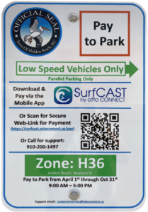 Paid Parking
Paid parking in Holden Beach
Paid parking will be enforced from 9:00 a.m. to 5:00 p.m. daily with free parking before and after that time. All parking will use license plates for verification.
Rates
Parking rates for a single vehicle in all designated areas will be:
$5 per hour for up to four hours
$20 per day for any duration greater than four hours
$80 per week for seven consecutive days
Handicap Parking
A vehicle displaying a handicap license plate and/or hang tag parked in a designated handicap space is free. Any other parking space will require a parking permit via the app.
Annual Passes
Annual permits for the calendar year allow vehicles (this includes low-speed vehicles and trailers) access to designated parking.
$175 for a single vehicle
Passes can be purchased via the app, website or by telephone.
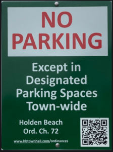
Where to Park
Per ordinance, there is no parking on the streets or rights-of-way except in designated parking spaces identified by Pay-to-Park signs. Click here to view an interactive map. The table with authorized parking can be viewed below.
Citations will be issued for:
-
-
- Parking without an active paid permit in a designated parking area
- Parking within 40 feet of a street intersection
- Parking in a crosswalk, sidewalk, or pedestrian access ways
- Parking blocking a driveway or mailbox
- Parking facing opposing traffic
- Parking in a no parking zone, or within right-of-way
- Parking on any portion of the roadway or travel lane
- Parking a non-LSV vehicle in an authorized LSV location
-
How Do I Pay to Park
The Town uses the SurfCAST by Otto Connect Mobile Solution. This is a mobile app downloadable for Apple and Android devices. Download the app today. Users will setup their account, enter their license plate details and pay for parking directly on the app. Alternatively, users can scan the QR Code located on the parking signs to access a secure website.
The Otto Connect customer service team will be available to help via phone and email.

Solid Waste Pickup Schedule
GFL Environmental change in service, October through May trash pickup will be once a week.
Please note:
Trash carts must be at the street by 6:00 a.m. on the pickup day
BAG the trash before putting it in the cart
Carts will be rolled back to the front of the house
GFL Refuse Collection Policy
GFL has recently notified all Brunswick County residents that they will no longer accept extra bags of refuse outside of the collection cart. This is not a new policy but is stricter enforcement of an existing policy. While in the past GFL drivers would at times make exceptions and take additional bags of refuse, the tremendous growth in housing within Brunswick County makes this practice cost prohibitive and causes drivers to fall behind schedule.
Solid Waste Pickup Schedule
starting October once a week
Recycling
starting October every other week pick-up
 Yard Waste Service
Yard debris is collected on the second (2nd) and fourth (4th) Fridays during the months of October, November, and December.Yard debris needs to be secured in a biodegradable bag (not plastic) or bundled in a maximum length not to exceed five (5) feet and fifty (50) pounds in weight. Each residence is allowed a total of ten (10) items, which can include a combination of bundles of brush and limbs meeting the required length and weight and/ or biodegradable bags. Picks-ups are not provided for vacant lots or construction sites.
THB Newsletter (12/11/25)
Yard Debris Service
The last yard debris pickup of the year is scheduled for December 26th.
Curbside Recycling – 2025
GFL Environmental is now offering curbside recycling for Town properties that desire to participate in the service. The service cost per cart is $119.35 annually paid in advance to the Town of Holden Beach. The service consists of a ninety-six (96) gallon cart that is emptied every other week during the months of October – May and weekly during the months of June – September.
Curbside Recycling Application » click here
Curbside Recycling Calendar » click here

Trash Can Requirements – Rental Properties
GFL Environmental – trash can requirements
Ordinance 07-13, Section 50.08
Rental properties have specific number of trashcans based on number of bedrooms.
* One extra trash can per every 2 bedrooms
..
§ 50.08 RENTAL HOMES.
(A) Rental homes, as defined in Chapter 157, that are rented as part of the summer rental season, are subject to high numbers of guests, resulting in abnormally large volumes of trash. This type of occupancy use presents a significantly higher impact than homes not used for summer rentals. In interest of public health and sanitation and environmental concerns, all rental home shall have a minimum of one trash can per two bedrooms. Homes with an odd number of bedrooms shall round up (for examples one to two bedrooms – one trash can; three to four bedrooms – two trash cans; five – six bedrooms – three trash cans, and the like).
Upon Further Review
 Christmas Trees Recycling
Christmas trees can be recycled to help build sand dunes on the beach. It is a way to build more protection on the shore by using them as a natural and biodegradable sand fencing. The trees are positioned facing downward at a 45-degree angle. Once the trees are laid down, they are left completely exposed except for the tips, which are covered in sand. The needles of the branches catch the sand, and it starts to accumulate until gradually the sand will bury the tree and build up the dunes around them. As the tree biodegrades, it provides nutrients to the other plants and organisms around it.

What to do with natural Christmas trees after the holidays
Whether it’s for trapping beach sand or grinding it for fresh mulch, consider upcycling that live Christmas tree you’ll be undecorating as the holiday season comes to a close. North Carolina Department of Environmental Quality’s Division of Coastal Management has released its annual guidelines for using natural Christmas trees as a substitute for traditional sand fending on oceanfront shores. All decorations must be removed before the tree is placed at the toe of the frontal dune or erosion escarpment, according to a division release. The trees should not block public or emergency vehicle accesses to beaches, hinder recreational use of a beach, or be placed on private property. Trees should also not be placed in a way that impedes, traps or otherwise endangers sea turtles, nests or hatchlings when the nesting season returns in a few months. For more information on how to properly use a live tree on oceanfront property, contact the Coastal Area Management Act permitting authority or appropriate Division of Coastal Management district office.
 Paid parking brought millions to Brunswick beach towns in 2025
After a busy summer, Brunswick County beach towns are seeing how much revenue was brought in from paid parking programs. As the holiday season is in full swing, towns are receiving year-to-date summary presentations on how well their paid parking programs did. Five waterfront towns in Brunswick County charge fees to park using OTTO Connect for their paid parking services. While some only charge the fee on a seasonal basis, one town enforces paid parking throughout the year. The towns combined to bring in more than $3 million. The municipalities of Bald Head Island, Caswell Beach, Southport, Calabash and Shallotte have not implemented paid parking programs. However, Southport considered it in 2025.
Here’s how the Brunswick County communities fared in paid parking revenue for 2025.
Oak Island
Gross revenue: $1,912,712
Total parked vehicles: 166,152
The town of Oak Island generated a total net revenue of $1,313,831 from their paid parking program, according to OTTO Connect CEO Jim Varner’s Nov. 12 presentation. Oak Island has been the only Brunswick County town with paid parking to raise its seasonal permit rate to $225. Oak Island enforces paid parking April 1 through Sept. 30 from 9 a.m. to 5 p.m., Varner suggested the town consider expanding its paid parking season until October. Varner said there was an increase in parking violations in 2025 due to an increase in resident only parking spaces. Parking rates are $5 per hour, $20 per day and $80 per week per vehicle. Residents can purchase up to three resident parking permits for $10 each. Residents can start purchasing 2026 parking permits in Dec. 2025. Visitor permits will become available in Jan. 2026, per the presentation.
Where to park: All on-island public parking spaces will be considered paid parking. Details: https://www.oakislandnc.gov/residents-visitors/parking-information.
Holden Beach
Gross revenue: $1,188,392
Total parked vehicles: 66,659
As of Oct. 8, 2025, the town of Holden Beach has generated a total net revenue of $803,148 from its paid parking program, Varner said on Oct. 21. Varner said he expects the town to make $880,000 by the end of the year. This will be a small bump from the nearly $830,000 made in 2024, per Varner’s presentation. The town of Holden Beach first implemented paid parking in 2022. Originally, the town enacted seasonal paid parking from April 1 to Oct. 31 with rates of $3 per hour, $15 per day, $60 per week, or $125 per year. In 2023 and 2024, the town increased parking rates to $5 per hour, $20 per day, $80 per week and $175 for a single vehicle annual pass and transitioned to year-round paid parking. OTTO Connect counted a total of 66,659 vehicles parked on the island so far this year, a decrease of nearly 81,000 vehicles counted in 2024. Over 26,000 vehicles were counted in parking spaces in June and July alone. Annual parking permits for 2026 are to become available in December 2025. All other permits will become available in January 2026.
Where to park: Holden Beach does not permit parking on streets or rights-of-way, except where designated by signs. Map with parking details is at https://www.scribblemaps.com/maps/view/HB-Parking/HBParking.
Ocean Isle Beach
Gross revenue: $749,500
Total parked vehicles: 43,694
For its first time charging for parking, Ocean Isle Beach generated a total net revenue of $512,554, according to Varner’s Nov. 10 presentation. “This was probably the exceptionally best first year in a town that we’ve ever had,” Varner said. The town enforces paid parking April 1 through Oct. 31 from 9 a.m. to 5 p.m. Parking rates are $5 per hour, $20 per day, $80 per week per vehicle and $175 per vehicle for an annual pass. OTTO Connect’s data showed the two most-used parking lots were Town Center Park and Monroe Street. Both parking lots have 30 parking spaces and Otto Connect counted over 6,700 vehicles parked at each lot throughout the paid parking season. “Most residents purchased a visitor permit and were not counted separately,” the presentation noted. Ocean Isle Beach’s paid parking season permits will become available in January 2026, per Varner’s presentation.
Where to park: Any designated parking spot on the island. Designated parking areas are free to park from 5 p.m. to midnight and 6 a.m.-9 a.m. No parking midnight to 6 a.m.
Sunset Beach
Gross revenue: $636,112
Total parked vehicles: 43,438
The town of Sunset Beach also initiated paid parking for the first time in April 2025 and fell close behind Ocean Isle Beach with a net revenue of $445,301, as of Oct. 6, 2025. “Frankly, Sunset Beach broke my model for revenue,” said Varner, noting the town exceeded his revenue expectation by almost $150,000. The town enforces paid parking April 1 through Oct. 31 from 9 a.m. to 5 p.m. Parking rates are $5 per hour, $20 per day, $80 per week per vehicle and $175 per vehicle for an annual pass. Property owners and residents can pay $25 for up to two vehicles. However, residency is confirmed using specific Brunswick County tax parcel information. Resident permits for the 2026 paid parking season with be available in December 2025 and seasonal parking permits in January 2026, per Varner’s presentation.
Where to park: Information on parking at Sunset Beach can be found at https://sunsetbeachnc.gov.
Varnamtown
The town of Varnamtown also kicked off a paid parking program at its boat ramp in 2025 and has received a net revenue of $1,695, town clerk Sandi Parrish told the StarNews. The town did not have an end of year report detailing the program’s gross income and parking data, Parrish said. Varnamtown started the program at the boat ramp on May 5 and ended it Oct. 15. The town set its parking rates at $20 a day for single vehicles and $40 a day for truck and trailers. Property owners are allowed one free parking permit per season.
During the paid parking season, the parking lot across the road from 32 Fisherman Road is visitor parking and the parking lot at the corner of Fisherman Road and Old River Road is designated for Varnamtown property owners only.
Read more » click here
Corrections & Amplifications
Zillow Removes Climate Risk Scores From Home Listings
The scores aimed to predict a property’s risk from a fires, floods and storms, but some in the real estate industry as well as homeowners have called them inaccurate.
Zillow, the country’s largest real estate listings site, has quietly removed a feature that showed the risks from extreme weather for more than one million home sale listings on its site. The website began publishing climate risk ratings last year using data from the risk-modeling company First Street. The scores aimed to quantify each home’s risk from floods, wildfires, wind, extreme heat and poor air quality. But real estate agents complained they hurt sales. Some homeowners protested the scores and found there was no way to challenge the ratings. Earlier this month Zillow stopped displaying the scores after complaints from the California Regional Multiple Listing Service, which operates a private database funded by real estate brokers and agents. Zillow relies on that listing service and others around the country for its real estate data. The California listing service, one of the largest in the country, raised concerns about the accuracy of First Street’s flood risk models. “Displaying the probability of a specific home flooding this year or within the next five years can have a significant impact on the perceived desirability of that property,” said Art Carter, California Regional Multiple Listing Service’s chief executive officer. In a statement, Zillow spokeswoman Claire Carroll said the company remains committed to providing consumers with information that helps them make informed decisions. Real estate listings on Zillow now display hyperlinks to First Street’s website, and users can click through to view climate risk scores for a specific property. The development highlights a growing tension within the real estate industry. Fires, floods and other disasters are posing more risks to homes as the planet warms, but forecasting exactly which houses are most vulnerable — and might sell for less — has proved fraught. First Street models have shown that millions more properties are at risk of flooding than government estimates suggest. Other real estate sites, including Redfin, Realtor.com, and Homes.com display similar First Street data alongside ratings for factors like walkability, public transportation and school quality. When researchers randomly displayed these flood risk estimates to 18 million people browsing Redfin, those who saw the feature were more likely to search for homes with low flood risk, according to a working paper published in the National Bureau of Economic Research last November. The Redfin experiment, which lasted for three months, affected sales of 8,150 properties that were listed as being at high risk of flooding and reduced their total sales prices by about 1 percent of their value, according to the paper. Zillow’s own research has found that homes with high fire and flood risk scores were less likely to sell than homes with medium or low scores, though it did not attribute the sales trends to the climate risk scores. The California Regional Multiple Listing Service has asked the other large real estate listing platforms to remove certain details about flood risks from their listings. “When we saw entire neighborhoods with a 50 percent probability of the home flooding this year and a 99 percent probability of the home flooding in the next five years, especially in areas that haven’t flooded in the last 40 to 50 years, we grew very suspicious,” Mr. Carter said. In many states, sellers are not required to disclose information about whether a house has flooded recently or if it is vulnerable to wildfires. Other sources of data, like the Federal Emergency Management Agency’s flood maps, have been criticized for being out of date. “With forward-looking models, we can’t check their outputs against a record, they are necessarily forecasting events that have not yet happened,” said Madison Condon, an associate law professor at Boston University who has studied climate risk. “The First Street models might provide a good enough answer for certain questions or certain hazards,” she said. “But what level of accuracy is good enough changes substantially if the question is about one specific property you are about to spend your life savings on.” In a statement Matthew Eby, First Street’s chief executive said, “Our models are built on transparent, peer-reviewed science and the full methodologies are publicly available for anyone to review on our website.” He added that the company’s models have been validated by major banks, federal agencies, insurers and engineering firms. When Melissa Savenko, a real estate agent, listed a home in Richmond, Va., for sale last summer, she said it immediately sparked interest from buyers in California, who made plans to hop on a plane to see the property. But then the buyers saw the Zillow listing with a flood risk rating of seven out of a maximum risk of 10. They canceled their plans. Ms. Savenko, who knows the neighborhood and sold the same house 15 years earlier, thought the flood risk rating was a mistake. She tried to get Zillow to remove it. “It made no rational, logical sense whatsoever that this one house was tagged with this crazy flood risk and houses around it had a one or a two flood risk,” she said. Zillow does not allow sellers to remove climate risk data upon request. Its competitors Redfin and Realtor.com do.
Read more » click here
What Zillow Won’t Tell You
When Zillow, the country’s largest real estate site, added information to property listings last year disclosing flood, wildfire, heat and air-quality risks, it was following its own research: More than 80 percent of home shoppers consider climate risk in their decisions. The data allowed families to weigh these risks before signing a mortgage. Last month, the scores disappeared from the listings. The real estate brokers and agents behind the California Regional Multiple Listing Service, one of the largest housing databases in the country, had complained about Zillow’s climate scores. Zillow partly depends on C.R.M.L.S. to supply its listings, and it removed them from every home on the site. C.R.M.L.S. and a few homeowners told The Times they questioned the validity of property-level forecasts, and C.R.M.L.S. said it grew “suspicious” when models showed high flood risk in places that hadn’t flooded in decades. But when Fast Company asked the listing service for an example, it pointed to a neighborhood in Huntington Beach — one that, in fact, flooded just recently. Zillow’s climate-risk scores came from First Street, a research firm whose flood and wildfire models have repeatedly outperformed the government maps that many Americans mistakenly assume are definitive. After the Altadena wildfire in January, a Los Angeles Times investigation found that state hazard maps flagged only about 21 percent of the homes that burned. First Street’s models identified 94 percent. C.R.M.L.S.’s real objection to including the data on Zillow is apparently less scientific than financial: Climate-risk scores might lower listing prices, which affect what real estate agents earn. But suppressing verified risk information is dangerous. When buyers can’t see the risks up front, they may take on more exposure than they can afford — homes that become too expensive to insure, with costs families didn’t anticipate, and, worst of all, natural disasters they hadn’t yet thought of in personal terms. Climate change has always been a battle on two fronts: physical and informational. The physical impacts are unmistakable — extreme heat, stronger hurricanes, deadlier wildfires, chronic flooding. But the informational battle has been intense, as well, with decades of deliberate efforts to cast doubt on settled science and remove it from public view. Now the “information war” has come to real estate, where the consequences of unknown risk can be particularly severe. Before Zillow, Redfin, Realtor.com and Homes.com started including climate risk information, most people had little way of knowing whether a property would be in harm’s way or not. About a quarter of states have no flood disclosure laws, and the federal government has said its own data is insufficient for fully assessing flood risk. Indeed, over 40 percent of flood-insurance claims made between 2017 and 2019 occurred outside its designated high-risk zones or areas that were not yet mapped, and about 75 percent of U.S. flood maps are outdated. In West Virginia, for example, a staggering 30 percent of properties face major flood risk, according to First Street, and yet sellers are not required to inform buyers about flood history or proximity to a flood zone. This means buyers could learn the truth only after the water rises, and after they’ve signed a 30-year mortgage. In many states, even homes that flood again and again can be patched up and sold to the next unsuspecting family. The financial fallout of all this is growing. Insurance premiums have soared in vulnerable regions like wildfire-prone Colorado — with median premiums up 74 percent since 2020. In some counties around the country, major insurers have withdrawn entirely. Buyers are often blindsided, learning only after closing that their insurance will double, triple or disappear. And as insurance prices rise, home values often fall. In areas like Lafitte, La., home values have dropped by 38 percent since 2020, and it’s becoming harder and harder to sell, The Times found. For home sellers and buyers in such high-risk zones, the difficult reality is that climate risks need to be both conspicuous and priced into listings. Consumers can insist that climate-risk scores return to Zillow, and in the meantime, use the platforms that still provide them, like Redfin, Realtor.com and Homes.com. Those companies are facing similar pressure from C.R.M.L.S., and hearing from buyers now matters. States can also strengthen disclosure laws so that a home’s flood or wildfire risk isn’t something buyers discover only after a disaster. As Susan Crawford, a climate adaptation scholar and writer, suggests, the government should fully fund a modernized flood mapping program that shows not only today’s risk, but how flooding is expected to change. Finally, real-estate platforms must stop fighting the facts and start preparing people for the dangers that already exist. Climate change is showing up as a material impact on more and more lives. The question now is whether Americans will be allowed to know the truth about it and make informed decisions to protect their financial security.
Read more » click here
Previously reported – October 2024
Zillow will now show climate risk data on home listings
The information is meant to help home buyers assess potential damage from extreme weather.
Potential home buyers are increasingly weighing the environmental threats their homes could face as the effects of climate change intensify across the United States. Eighty percent of buyers now consider climate risks when shopping for a home, according to a 2023 Zillow survey. To help homeowners navigate that uncertainty, Zillow is adding a climate risk threat score to every for-sale listing on its platform. Data from First Street Foundation, a nonprofit that assesses climate risk, will provide home buyers with scores that measure each property’s susceptibility to flood, wildfire, wind, heat and air quality risks. This information will be available on the Zillow app for iOS and website by the end of this year, while Android users will be able to access the data in early 2025, the company said in a release last month. Home buyers will be able to view this data on Zillow in two ways, either by looking at information within individual listings or by checking an interactive, color-coded map. The scores will display each home’s current climate risk, as well as the risk estimates for 15 and 30 years in the future — the most common terms for fixed-rate mortgages. Zillow also plans to offer tailored insurance recommendations to users alongside the risk information. First Street’s climate risk scores are established through models that measure the likelihood of a climate disaster in a given area and then the potential severity of the event, according to Matthew Eby, the company’s founder and chief executive. The company updates its models each year based on the natural disasters that have unfolded, Eby said. “This level of transparency is allowing people to choose the level of risk that they find comforting and then make an informed decision,” Eby said. “Will this change the buying experience? Absolutely.” The Zillow upgrade comes at an uncertain time for home buyers as climate change becomes more extreme. Some of the largest U.S. insurance companies have ended certain disaster protection coverage and raised premiums in response to climate risks, The Washington Post has reported. And more home listings today are affected by major climate risks compared to just five years ago, according to a report from Zillow published last month. Across all new home listings in August 2024, nearly 17 percent were at major risk of wildfire, while nearly 13 percent came with a major risk of flooding, the company said. This information could be especially valuable given that many states don’t require home sellers to disclose past flood or fire damage to potential buyers, even though more than 300,000 Americans moved to disaster-prone counties last year, The Post previously reported. A 2022 Post analysis of extreme flooding events across the country found that the Federal Emergency Management Agency’s flood maps fail to fully inform Americans of their flood risks. In a 2022 study published by real estate company Redfin, home buyers who had access to property listings that included flood risk information were less likely to view or bid on high-risk homes. That finding indicated a massive information gap for buyers regarding a home’s climate risk, according to some experts. “The information it provides is beneficial because otherwise, there’s just nothing out there for a home buyer or a renter to learn about the risk that they’re facing,” said Joel Scata, a senior environmental health attorney with the Natural Resources Defense Council. “Even if there’s debate over the methods used or the processes used, it’s better than nothing.” It’s difficult to determine the reliability of many climate risk models because the vast majority are not publicly accessible, said Benjamin Keys, a professor of real estate and finance at the University of Pennsylvania’s Wharton School who has studied the effects of climate-change-fueled disasters on insurance markets. But since the amount of climate-threat information buyers typically have has been “astonishingly low” for years, any improvement would aid transparency in the industry, he added. Climate risk modeling experts are still developing the best possible way to measure the probability of flooding, fires and other natural disasters in any given area, notes Jesse Keenan, a professor of sustainable real estate and urban planning at Tulane University. The data provided from consumer-facing models can be “uneven” depending on where a person is house-hunting, because some risks have been studied more extensively in certain regions than others, he said. “They’re not great,” Keenan said. “Some places they work well, and there’s a lot of places where the uncertainty is greater than the value.” Still, most prospective home buyers will weigh climate risks early in the hunt, and data on these risks can help flag issues they should investigate further, Keenan emphasized. For example, if a score indicates that a house is at a high risk of flooding, home buyers should talk to neighbors about their experiences or show up to the property on a rainy day. The tool should signal the start of the information-gathering process about a home’s climate risk, rather than the end, Keys added.
Read more » click here
Odds & Ends
County’s fire tax funding issue remains unresolved
Brunswick County leaders told commissioners Monday they may be forced to dip into county funding to meet the needs of local fire departments if a proposal to change the fire tax system is not approved. County Manager Steve Stone informed commissioners they should vote in January on a one-time general fund subsidy of at least $10 million if changes aren’t made to the system funding local fire departments. “We need 10 to 12 million dollars to stabilize our fire protection system,” Stone said. The manager recommended that the funds be made available to fire departments on July 1, 2026 as part of the 2027 fiscal year budget. The manager made it clear he only wants to dip into the fund one time. “I will state now this is a one-time proposal,” Stone said. Both county leaders and fire officials agree several factors are stretching fire department budgets. Southport Fire Chief Charles Drew, who leads the Brunswick County Fire Chief’s Association, told commissioners demand for service around the county has nearly doubled in the last several years. The demand is largely due to the county’s status as the fastest growing county in North Carolina. The county has seen approximately a 24% increase in population since 2020. “There is a high demand for fire services in our county,” Drew said. Drew also said there is a sense of urgency to the matter. It can take as long as four years to deliver new fire trucks that are ordered. “Fire department funding should not be put on the back burner,” Drew said. The need for more paid staff is also an issue. Nationwide there has been a decline in the number of volunteers serving local departments which creates a need for more paid staff. Officials have proposed moving the county from a system of fire fees to a new system implementing a fire tax based on property value. Commissioners have expressed concerns in recent months that a new fire tax might reduce the chances of passage of a much needed school bond referendum in November. While Stone’s proposal Monday didn’t require board action, several commissioners spoke on the matter. They said in unison they want to support local fire fighters and first responders. “We need a system that will support all the people of Brunswick County,” Commissioner Frank Williams said. “I cannot say enough about the commitment of those involved in the fire service,” Commissioner Marty Cooke said. “Regardless of the school bond referendum, we need to get this right.” In other action, the board voted to re-elect its top leadership. Commissioner Mike Forte was re-elected as the board’s chairman and Cooke was renamed as vice chairman. Commissioner Pat Sykes voted against both leadership positions. She did not state publicly why she was opposed to the two appointments. The board also voted to donate 17.5 acres of land to Brunswick Community College to be used for a fire service and driving pad training facility. The site is located on Galloway Road, near U.S. Hwy. 17. The board previously donated 10 acres of land for the project but that land couldn’t be used because of wetland regulations.
Read more » click here

Every year, the independent nonprofit ratings agencies Charity Navigator and Candid Guidestar evaluate charities nationwide based on fiscal transparency, accountability, and effectiveness. We are thrilled to share that this year the Coastal Federation earned the highest ratings from both Charity Navigator and the Candid Guidestar. Review the details on Charity Navigator and Candid Guidestar.
As a Federation supporter, you can be proud to support an organization earning top marks nationwide and you can be confident that your donation will be put to good use.
Mission:
Since its founding in 1982, the North Carolina Coastal Federation has worked with citizens to safeguard the coastal rivers, creeks, sounds and beaches of North Carolina. Headquartered in Newport, North Carolina with offices in Wanchese and Wrightsville Beach, the Coastal Federation works in three key program areas: environmental advocacy; restoring and protecting habitat and water quality; and educating citizens and community leaders. Our vision is for a natural, beautiful, and productive coast that is a great place to live, work and visit. Today the Coastal Federation consists of more than 11,000 supporters, 200 partner organizations, thousands of active volunteers and a 30-member professional staff and is considered one of the most effective coastal conservation groups in the state. The Coastal Federation remains a collaborative, grassroots organization, bringing together traditional and nontraditional organizations, government agencies and businesses to leave a legacy of a healthy coast for future generations.
Noem at odds with Trump-appointed panel over future of FEMA
Instead of further shrinking and dismantling FEMA, the FEMA Review Council wants to make it more independent.
A panel appointed by President Donald Trump to review whether to eliminate the Federal Emergency Management Agency has instead concluded in a report that the agency should be more powerful and autonomous. Homeland Security Secretary Kristi L. Noem, however, wants to take FEMA in a different direction. The wrangling over the FEMA review council’s long-awaited report, which has been in the works for nearly 10 months, will help determine the fate of one of Trump’s controversial efforts to reshape the government and its ability to respond to disasters such as floods, fires and hurricanes. Noem, as the council co-chair, is responsible for finalizing the report and sending it to Trump for review. Her draft, which is not finished, recommends keeping FEMA within the Department of Homeland Security and largely removing FEMA from its direct role in disaster relief, instead turning it into more of a grant-making operation, according to five people familiar with the situation who spoke on the condition of anonymity to discuss the private deliberations. The council’s earlier draft did not recommend those changes, but rather that FEMA gets elevated to a Cabinet-level office. Noem’s office also wants to reduce the federal government’s share of disaster-related costs to 50 percent, with states having to fund the other 50 percent with cash, which some council members staunchly opposed, according to a person familiar with the situation. Under FEMA guidelines, the federal government covers about 75 percent of costs, and in extreme cases it will front nearly 100 percent for a period of time. The council is recommending FEMA keep its current cost share responsibility, which is defined by the Stafford Act. A spokesperson for DHS denied Noem was trying to alter the report. “Secretary Noem is the Chairwoman of the council and has worked with committee members collaboratively on the reform report,” DHS spokeswoman Tricia McLaughlin said in a statement. She said the council has “spent months working to provide recommendations to reshape and reform the bureaucratic mess that exists at FEMA.” The negotiations over the report are still in flux, and the president’s final decision is not yet clear, according to people familiar with the process. Since he initially floated “reforming and overhauling FEMA — or maybe getting rid of FEMA” in January, Trump has met with first responders and victims’ families in disaster areas and heard from advisers and Republican officials who oppose eliminating the agency. The final report, which carries no legal weight but is a recommendation to the president for FEMA’s next steps, is expected in mid-December. The New York Times first reported details of tensions around the FEMA Review Council’s report earlier Wednesday. White House spokeswoman Abigail Jackson described the council’s mandate as recommending how to make sure “the federal role remains supplemental and appropriate to the scale of disaster.” “Secretary Noem is working hard to implement the President’s vision that will best serve the American public,” Jackson said. Trump, who has been highly critical of FEMA, appointed the council in part to address criticism of the way the federal government responds to natural disasters, according to people involved in the process. The 10-member council, led by Noem and co-chaired by Secretary of Defense Pete Hegseth, is composed of Republican state and local elected officials, a veteran FEMA official and an insurance CEO. “When we first heard about the creation of this council, I think there were concerns that it would not do its due diligence,” said Pete Gaynor, who led FEMA for a time during Trump’s first administration. “But I think the council has done some pretty good work. I think they have made some positive recommendations on turning this thing from an overly complicated recovery process to something more simplified I think meets everyone’s goals.” In early November, the council submitted a 160-page draft proposal on how to revamp FEMA and improve the country’s disaster response system — the result of about 13,000 public comments and about a dozen public and closed meetings with communities, many small and rural, from Puerto Rico to Louisiana to Wyoming to California. The overarching conclusion aligned with Trump’s impulse to push more disaster-response capabilities and decisions to states. But the council, according to a person involved in the process and a review of meetings, became more focused on improving and elevating the agency, rather than shrinking or eliminating it. “President Trump is putting Americans first by creating a once-in-a-lifetime opportunity to methodically align and strengthen how emergency management is integrated across all levels of government,” Kevin Guthrie, Florida’s director of emergency management, said during an August FEMA review council meeting in Oklahoma City. “We don’t get an opportunity to hit the reset button often, and we’ve been given that opportunity through this committee.” Some of the council’s detailed suggestions include making it easier for disaster-stricken residents and communities to get FEMA’s Individual and Public Assistance funds by accelerating the dispersal of funding to the communities and reforming how FEMA manages the National Flood Insurance Program, according to three people familiar with the report and a copy of its table of contents. It also proposed moving FEMA out of DHS and making it a Cabinet-level department. But after the report’s submission, Noem and her top adviser, former Trump campaign manager Corey Lewandowski, cut the draft proposal to fewer than 20 pages, while keeping open the possibility of releasing the rest as supplemental material, officials said. Some White House officials received a copy of the council’s unedited draft, according to two people familiar with the matter. “It’s like Edward Scissorhands,” a person familiar with the situation said of Noem’s edited version of the report. “She wants to chop it up and decentralize and really drastically limit FEMA. Many members on the council are not happy with how she has put her thumb on the scale.” Noem’s revisions also include a recommendation to further cut FEMA staff by about half and have FEMA only handle debris removal and emergency protective measures when responding to a disaster, moving most of its other work — such as helping repair damaged utilities, roads and bridges, public buildings and parks — to other agencies, according to a person familiar with the reports. In addition, about a month ago, Noem announced a desire to relocate FEMA’s headquarters from D.C. to Texas, which Politico first reported. Those ideas concerned some experts on the council who warned that state and local governments lack the resources to take over those responsibilities from FEMA and that the changes needed to be phased in to give states and local communities time to shift their budgets to better support their own emergency management capabilities. After Trump commissioned the council through an executive order in January, the administration had largely pinned FEMA’s future on what the council would suggest. The members took that mission seriously, according to people familiar with the process. While it was clear to some that Trump and Noem both desired to get rid of FEMA as it exists today, members of the council spent months sifting through feedback from all corners of the U.S., including tribes that often struggle to get federal disaster assistance, and determined that FEMA needed to make its programs more accessible to rural regions, according to people familiar with the report. The council also highlighted the need to mitigate risk by enabling communities to rebuild more safely, they said. That effort, one person said, created some tension between some council members and Noem and Lewandowski, who would often come into their meetings and interject his thoughts. One example is Noem’s proposal to move FEMA to Texas, and potentially tap Nim Kidd, the head of the Texas Division of Emergency Management and a member of the council, to lead the agency. She argued that relocating the agency’s headquarters was one of Trump’s desires, according to two people with knowledge of the situation, who added that some members of the council were shocked by the proposal. That shift had not been something the council was discussing, and relocating much of the agency’s operations out West seemed counterintuitive to the council’s goal of enabling FEMA to operate more efficiently and nimbly when responding to disasters across the U.S., those people said. White House officials told some council members that the relocation was not one of Trump’s priorities. Transferring much of the agency’s operations nearly across the country would make it much harder to coordinate a federal emergency response, experts and current and former officials said, especially since one of FEMA’s key responsibilities is ensuring that the executive branch can function during a national emergency, such as a terrorist attack, and overseeing national emergency communication systems. For the last few months, there has been speculation as to whether Noem would accept the council’s outline for the future of FEMA and thus the nation’s disaster response framework. At the National Emergency Management Association’s conference last month, Guthrie, the Florida emergency management director, addressed attendees, telling them about the much-awaited council report. Cameron Hamilton, FEMA’s former acting administrator whom Noem fired this spring for going against her desire to eliminate the agency, then asked him a blunt question: “What degree of confidence do you have that [the] report that you submit to DHS will be what is submitted to the president?” “[Guthrie] sighed,” Hamilton recalled. “He said he feels confident in the report that they will submit to the Secretary. And that’s where he stopped.”
Read more » click here
This and That

Why deer-car collisions are rising in the Wilmington area, and November is the worst month
As development pushes out from Wilmington, deer-vehicle collisions are on the rise. But the number of deer also appears to be increasing as they adapt and hunting becomes more difficult in many areas
Billy Sampson said he didn’t see much before the collision. The sun had just set as he drove on Sidbury Road in northern New Hanover County headed home from work in November 2024. Just a streak crossing the road before the crash, and then a young doe sitting on his cracked windshield, her neck broken. “You just don’t have time to react,” Sampson said. “It happens before you know it.” Luckily, the damage to Sampson’s car was minimal, and he escaped the incident with only frayed nerves. But deer-vehicle collisions are an increasingly common occurrence in the Wilmington area as the region continues to boom. With subdivisions popping up in formerly off-the-beaten-track areas, deer and human interaction are rising. And with white-tailed deer among the most adaptable of all large animals in North America, in many areas their number are increasing just as the number of residents around the Cape Fear coast and other fast-growing parts of the Tar Heel State continue to rise. The result is an increase in deer-vehicle collisions on area roads after a slight downturn during the COVID-19 pandemic shutdown due to the reduction in traveling. With November the most common month for collisions, here’s a look at why drivers might want to pay a bit more attention out driving over the next few weeks and why this could be a troublesome situation that’s here to stay.
By the numbers
According to the N.C. Department of Transportation’s latest animal-related crash report, which tracked animal-vehicle collisions stretching back to 2017, last year showed a rising trend of incidents. Brunswick County saw the highest number of collisions in the Wilmington area, with 1,422 between 2022-24, ranking ninth in the state. Pender County saw 1,103 crashes over the same three-year period. The damage caused by the 2022-24 collisions was valued at $4.6 million in Brunswick and $3.4 million in Pender, with 39 total injures in Brunswick and 49 − including one fatal − in Pender. Fast-growing Wake County, home to Raleigh and Cary, saw the most animal crashes out of North Carolina’s 100 counties in the 2022-24 period, recording 2,676. Although state collision report forms don’t distinguish between animal types, data analyses shows that approximately 90% of all reported animal related crashes involve deer. In all three counties, 2024 saw the highest number of crashes − a trend that’s been increasing since 2020. While that’s partly due to the COVID-19 pandemic-related restrictions earlier this decade, which severely curtailed people’s traveling, the figures also likely reflect the tremendous population growth the three counties have seen in recent years. Brunswick County, for example, has seen it’s population jump from roughly 136,000 in 2020 to an estimated 175,000 in 2025. Due to its relatively small size and largely urban nature, deer-vehicle collisions in New Hanover County aren’t as high as larger counties, but are still a worry − especially as development pushes into the undeveloped northern parts of the county. According to the DOT report, New Hanover saw 86 collisions in 2024, and 250 in the 2022-24 window. That ranked 73rd in the state.
When are collisions most common?
According to the DOT report, the most collisions, 23% of the 63,487 recorded statewide 2022-24, occurred in November. Officials say a “perfect storm” of factors is to blame for this. They include November representing the height of the deer-mating season, which sees the animals on the move more than normal. Bucks especially can act erratically and with less caution as they chase does. Throw in Daylight Saving Time, which sees the clocks moved back in early November and means shorter days and more darkness during peak travel times, and it’s harder for drivers to see deer just when they are most active. According to the DOT, tips to help lower the chance of an animal collision include slowing down in areas known to be frequented by deer; driving with high beams on as much as possible; slow down and blow your horn if you see deer on the side of the road; and keep a safe distance between vehicles to help prevent you from becoming collateral damage if the car in front of you strikes a deer. After November, the three months that saw the most deer-car collisions were October (14.6%), December (12.9%) and January (8.2%). The DOT report also listed times that most crashes occur, and not surprisingly there were centered around dawn and dusk, with 6 a.m. the worst hour with 9.1% of all crashes. Next was 8 p.m., with 8.4% of crashes.
Why are collisions on the rise?
In many areas of Southeastern North Carolina, deer have always been a common part of the landscape. But as areas that used to be forest are turned into subdivisions and shopping centers, people and deer are coming into contact more often. That, however, doesn’t mean deer numbers are dropping per se. Deer, like coyotes, are very adaptable, and can easily live among human development, sharing parks and wooded areas just around the corner or even within neighborhoods. Limits on hunting in many areas due to public sentiment and safety concerns along with a lack of natural predators, aside from cars, also has allowed deer numbers to explode in many areas. That many yards and gardens include deer-friendly shrubs and flowers also has helped keep the mammals close to suburbia, since finding food is no longer a problem. According to the N.C. Wildlife Resources Commission, there are an estimated 1 million white-tailed deer in the state, a figure that’s remained relatively stable for a few decades. But while some rural areas have seen deer numbers fall slightly, the opposite has been happening in some of the state’s fast-growing metro areas. “Those areas where populations are rapidly increasing are typically urban/suburban areas where the utilization of hunting as a management tool has been greatly hindered,” the wildlife commission stated on its website. The combination of a lack of predators, a hunting ban and a deer smorgasbord of tasty garden treats saw Bald Head Island’s deer population surge in the late 1990s and early 2000s, prompting the ritzy Brunswick County island to turn to contraception to try and control its herd. But that isn’t an option, due to cost and questions of its effectiveness, for most communities. In areas where hunting remains popular, harvest numbers appear to be rising even as deer-vehicle collisions also are ticking up. In Brunswick County, for example, 2,128 deer were harvested in the 2024-25 season. That compares to 1,737 a decade before in the 2014-15 season, according to the wildlife commission. Pender County showed a similar trend, with hunters taking 3,070 deer in 2024-25 compared to 2,622 in 2014-15. Overall, N.C. hunters harvested nearly 189,000 deer during the 2024-25 season.
Read more » click here
 Fear the deer: Crash data illuminates America’s deadliest animal
Behold the deer, the deadliest beast in North America. Deer are responsible for the deaths of about 440 of the estimated 458 Americans killed in physical confrontations with wildlife in an average year, according to Utah State University biologist Mike Conover, employing some educated guesswork in the latest edition of “Human-Wildlife Interactions.” Those deer-inflicted fatalities are not, so far as we know, caused by deer-on-human predation. They’re the unfortunate result of more than 2 million people a year plowing into deer with their sedans and SUV’s, usually on a two-lane road, often at high speed. You might wonder: Where and when am I most likely to hit a deer? And how can I avoid it? To shed light on this herbivorous hazard, we turned, of course, to data. Specifically, we analyzed more than 1 million animal-vehicle collisions compiled by Calumn Cunningham, Laura Prugh and their colleagues at the University of Washington for a recent paper published in Current Biology. They estimate deer were involved in more than 90 percent of the collisions, which occurred in 23 states between 1994 and 2021. With a few exceptions, the data show deer are at their most dangerous in November. Indeed, the deer threat peaks just before Thanksgiving typically Nov. 7 through 14 when you’re about three times more likely to hit a deer than at any other time of year. Experienced deer hunters can probably guess why driving in November can turn into Russian roulette on certain highways and byways: In much of the country, that’s rutting season. And during the rut, deer focus on procreation, not self-preservation. Marianne Gauldin of the Alabama Wildlife and Freshwater Fisheries Division compares rutting bucks to teenage boys. “They are hyper-focused on the opportunity to breed, and they therefore lose some of their wits,” Gauldin said. “They are full tilt looking for does, chasing does and running after does for the opportunity to breed. And they are doing this with tunnel vision … literally running across the road.” Does share similar distractions. They’re either in estrus hormonally receptive to sex and looking to breed or fleeing hot-and-bothered bucks until their cycles catch up. Collisions occur more often in states with the most white-tailed deer which experts say tend to have a shorter, sharper rut than the western mule deer and in states with long stretches of busy rural roads. Separate insurance claim data from State Farm, which is widely cited in academic research, shows a driver out minding her own business on the wending, bending roads of West Virginia had a 1 in 35 chance of hitting an animal between June 2021 and June 2022, making the Mountain State easily the most dangerous in terms of deer-car collisions. Montana and Michigan were next. D.C. drivers, by contrast, had only a 1 in 907 chance of stopping a buck while driving down Pennsylvania Avenue, or anywhere else. Fun fact: Deer are responsible for at least 69 percent of animal-related accident claims, according to State Farm. Another 12 percent of claims involve unidentified animals, many of which could be deer that bounded off before the driver got a good look at them or were mangled beyond recognition in the crash. The third-most-dangerous animals on the road are undifferentiated rodents, which are cited in 5 percent of all animal-related accident claims. However, State Farm spokesperson Dave Phillips noted that many of the drivers never make contact with said rodent: The vast majority of those accidents occur when motorists swerve to avoid a suicidal squirrel or moseying marmot. Our more calendar-conscious readers will note that peak deer-crash season coincides with another big moment in November: the first week of daylight saving time, which begins the first Sunday of the month. And the University of Washington team has found that the two events are not unrelated. To understand why, we need to spelunk deeper into their data, which breaks new ground by including the exact location, date and hour of all these deer disasters. When we glance at a chart of accidents that includes time of day and time of year, one fact strikes us right between the headlights: Evening, the twilight of each day especially in November is the hour of the Gotterdeermmerung. Conveniently for us, the University of Washington scholars used accident coordinates and some basic weather math to calculate exactly when the sun would have risen or set at each location. It turns out that deer danger skyrockets about 30 minutes after sunset and remains extraordinarily elevated for almost half an hour. Those with deer-behavior expertise say drivers should be on high alert as darkness falls in autumn especially when careening through the deer’s favorite transitional habitats, the forest-edge ecosystem created by roads and other developments. But they urge us to take a lesson from the thousands of people who land in hospitals and body shops each year after attempting to avoid a turtle or chipmunk: If you do see a deer, don’t swerve. “Slow down as much as you can, obviously, coming up to it,” said Karlin Gill of the National Deer Association, a hunting and conservation organization. “But if it’s unavoidable and you’re going to hit the deer, don’t try and swerve out of the way. That can cause an even worse car wreck, and you still might hit the deer regardless.” Deer crashes also rise in the morning, about 30 minutes before sunrise, but the number is significantly lower than after sunset. To understand why, we need to dig deeper into both deer and human activity patterns. Biologist after biologist told us deer are crepuscular, meaning they’re most active at dawn and dusk. When Texas A&M University wildlife scientist Stephen Webb and his colleagues fitted GPS trackers onto white-tailed deer in Oklahoma, they found deer movement peaks at both sunrise and sunset. “Deer, unlike humans, don’t lay down for eight hours at night and then get up and move throughout the day,” said Gill , who, as a hunter, closely examines deer behavior. “They actually go through a cycle where they’ll lay down, bed, get up, eat, lay down, bed, get up, eat, and they’ll do this throughout a 24-hour period.” But if deer are equally active at dawn and dusk, why are they so much more likely to be hit in the evening? To untangle that one, we need to examine another somewhat crepuscular species: the American commuter. Our commutes also peak in the morning and evening, but we’re much more likely to be driving at dusk than we are at dawn, and we stay on the roads even as darkness falls, and the deer start moving often squarely into our headlights. It’s a matter of visibility. Deer are just as active two hours before dusk as they are two hours after, yet we’re about 14 times more likely to hit a deer after sundown than we are before. And, as Cunningham notes, right at the peak of the whitetail rut, we throw another variable into the stew: We end daylight saving time. Suddenly, as far as the deer are concerned, our 6 p.m. commute happens an hour later. Millions of drivers find themselves contending with lower visibility just as sex hormones flood the local deer population. “It’s like one of the grandest-scale natural experiments that we can come up with, where humans impose these very arbitrary and abrupt changes on the wildlife,” Cunningham told us from his native Tasmania (he’s at the University of Washington as a Fulbright fellow). People living on the far eastern side of a time zone are about 1.35 times as likely to hit a deer as folks on the far western edge, since folks in the east are more likely to be driving home in the dark. Similarly, folks in Northern states, where days are short and darkness rules the winter, are 1.86 times more likely to hit a deer than their friends in America’s sunny South. Taking these effects into account, the University of Washington team estimates that “falling back” causes a 16 percent jump in deer carnage in the weeks after the shift. It’s possible that adopting permanent daylight saving time would thus save the lives of more than 36,000 deer and 33 humans each year. On the down side, chronobiologist Eva Winnebeck of the University of Surrey argues that any gains might be offset by an increase in deaths spurred by the chronic drowsiness that would inevitably set in if our solar-powered circadian rhythms were forced to endure a never-ending disconnect between the sun and clocks set permanently to daylight saving time. Here at the Department of Data, we’ve found a strong connection between happiness and the great outdoors. So, we’re partial to any move that would give us more daylight hours to get out after work and fish, run or dominate the competitive wood-chopping circuit, circadian rhythms be darned.
Read more » click here
Watch out for deer
NCDOT warns motorists across North Carolina to stay alert for deer now that fall has arrived. Every year during late autumn, auto and body shops across the region brace for a bumper crop of business, comprised of an influx of cars with damage from collisions with deer. Beginning in October, roads across the state become hazardous as North Carolina’s deer population fans out, lurking on highway shoulders in search of food and potential mates. It’s the deadliest time of the year for deer, which also pose a particular danger to motorists. Nearly half of vehicle accidents involving white-tail deer occur from October to December. Deer accidents typically begin rising in October, peak in November and begin dropping off after December, according to the Insurance Institute for Highway Safety. Deer are crepuscular mammals, meaning they’re most active at dawn and dusk which, following the onset of daylight savings time, places them near roads and byways precisely when large numbers of residents are commuting to and from work.
NCDOT has some helpful tips for motorists in regard to deer-vehicle crashes:
-
- Although it does not decrease the risk of being in a crash, wearing a seat belt gives you a better chance of avoiding or minimizing injuries if you hit a deer or other animal.
- Always maintain a safe amount of distance between your vehicle and others, especially at night. If the vehicle ahead of you hits a deer, you could also become involved in a crash.
- Slowdown in areas posted with deer crossing signs and in heavily wooded areas, especially during the late afternoon and evening.
- Most deer-vehicle crashes occur where deer are more likely to travel, near bridges or overpasses, railroad tracks, streams, and ditches. Be vigilant when passing through potentially risky landscapes.
- Drive with high beams on when possible and watch for eyes reflecting in the headlights.
- Deer often travel in groups, so if you see one deer near a road, be alert that others may be around.
- If you see deer near a road, slow down and blow your horn with one long blast.
- Do not swerve to avoid a collision with deer. This could cause you to lose control of your vehicle, increasing the risk of it flipping over, veering into oncoming traffic, or overcorrecting and running off the road and causing a more serious crash.
Officials say the most crashes occur between 6 p.m. and midnight, accounting for about 45% of the overall total. With the end of daylight savings time at 2 a.m. Sunday, Nov. 1, the time shift increases the chance of deer being by roadways when drivers are traveling in the dark, especially for their evening commute. If your vehicle does strike a deer, officials say do not touch the animal. A frightened and wounded deer can be dangerous or further injure itself. Get your vehicle off the road if possible and call 911.
Read more » click here
Factoid That May Interest Only Me
Where is Everyone Moving? Unpacking the Top Migration Trends of 2025
Historically, Americans haven’t shied away from charting new courses, and U.S. residents’ interest in migrating to new areas of the country continues to follow that path. In the first half of 2025, we tracked migration interest, or curiosity about living in a new city or state, among U.S. residents via online searches. Our data on the top cities and states that U.S. adults have searched online through June 2025 shows a heavy focus on the South, as well as a few states in the Northeast and West and coastal regions across the country. We looked into the possible reasons these regions are so appealing to residents wanting to make a move, whether it’s for their milder weather, more affordable housing or lower taxes, for example.
The Most Sought-After States: Diving Into the Top Tier
The most interest is directed at Southern states, with the Northeast, Midwest and West regions also represented. Ranging from South Carolina to Alaska, the most searched states vary in climate, lifestyle and job availability, but they all provide plenty of outdoor recreational opportunities, with half offering many miles of ocean coastline.
States with the highest domestic migration interest, based on total internet searches in the first half of 2025, are:
-
-
- South Carolina
- North Carolina
- Tennessee
- Delaware
- Idaho
- Alabama
- Minnesota
- Maine
- Arkansas
- Alaska
-
Coastal States
The appeal of coastal areas in popular state destinations like Delaware, Maine, North Carolina, and South Carolina is clear. With their natural beauty, all of these states are also popular vacation destinations. The Atlantic Ocean coastline provides recreational opportunities as well as fresh seafood. However, the climate varies widely from Maine to South Carolina, so the reasons for moving to a particular coastal state may come down to factors like weather, affordability, and job market. Topping the list of states with the highest migration interest, South Carolina is popular for retirees because of its low property tax rates and tax exemptions for older adults. It’s also popular for its mild climate, recreation possibilities, proximity to the Atlantic Ocean and economic opportunities. North Carolina offers the Atlantic coast on the east and mountains to the west, with countless opportunities to enjoy its scenic beauty. The state’s Research Triangle provides employment opportunities, so moving to this state could benefit individuals and families looking for a higher quality of life. Moving to the north, Maine is a more affordable option compared to other East Coast states like Massachusetts. Unlike other popular coastal states, its features include a rugged coastline and a network of more than 2,000 coastal islands, giving it a distinctive look. Delaware is tax-friendly, as there’s no sales tax or state tax on Social Security benefits. Add that to the miles of beaches in the state, and it’s easy to see its appeal for a diverse population. In fact, Delaware’s popularity is increasing, jumping from the 22nd most popularly searched state in the first six months of 2024 to No. 4 in the first half of this year.
Southern States
Besides South Carolina and North Carolina, Alabama also has small coastal areas to the south, although most of the state is landlocked, as are Arkansas and Tennessee. Some reasons these states may be rising in popularity include the milder weather that living in the South affords, along with recreation opportunities and a lower cost of living. Tennessee is also known for its rich musical heritage, culture and natural wonders, including the Great Smoky Mountains along its North Carolina border, making it a popular state for outdoor enthusiasts. Alabama offers affordable housing and a diverse landscape, making it ideal for both families and nature enthusiasts. Ranking No. 1 in affordability in U.S. News and World Report’s Best States rating, Arkansas has a low cost of living and affordable housing, perfect for people wanting to start fresh, as well as families hoping to stretch their budgets.
Midwest States
Minnesota is the only Midwest state on our list of the most popularly searched states, and it has some good things going for it, despite its harsh temperatures and heavy snowfall during the winter months. Like Delaware, it jumped in popularity from the first half of 2024 to the first half of this year, from No. 32 to No. 7. Known as the Land of 10,000 Lakes, Minnesota has abundant natural resources for recreation like hiking and fishing, as well as a strong economy and low unemployment rate.
Western States
It’s not surprising Idaho is popularly searched for people looking to move to another U.S. spot, since it offers a relaxed lifestyle and lower cost of living than many other mountain states, as well as geography that allows for many different types of outdoor activities. Idaho also appears in the No. 6 spot in U.S. News’ rating of states with the best economies. Perhaps more surprising is Alaska, which rounds out the top 10 most-searched states. The 49th and largest state in the U.S., it’s certainly a draw for those who want to immerse themselves in nature and live a simpler lifestyle, offering abundant coastal and forested areas in its more temperate southern climate zone, such as in Sitka and Anchorage. However, it has a high cost of living, extreme temperatures in parts of the state and limited transportation options in some areas, including no road access. In addition, like other coastal areas that have seen flooding and erosion due to rising temperatures, Alaska is experiencing this as well, but at a faster pace.
The States With Less Appeal: Exploring the Bottom of the List
States that were the least searched online for relocations in the first half of 2025 – starting with the least searched – include:
-
-
- New Jersey
- California
- New York
- Connecticut
- Nebraska
- Maryland
- Massachusetts
- Rhode Island
- North Dakota
- Virginia
-
High Cost of Living
Something most of these states have in common – except for Nebraska and North Dakota – is a high cost of living. This can also translate into less affordable housing, especially for people on a limited income, like retirees. The areas with the highest cost of living include Massachusetts, California and New York.
Extreme Weather
Most of these states also experience periods of extreme cold during the winter along with heavy snow. North Dakota, in particular, sees an average of 50 days per year with below zero temperatures. For those looking for year-round sunshine, most of these states won’t make ideal options.
Population Density
People who want to relocate to less populated areas should avoid the following states or regions, which have the highest population density: New Jersey, Rhode Island, Massachusetts, Connecticut and Maryland, with New York also included in the top 10.
Tax Burden
California, Rhode Island and New Jersey have high sales tax rates, which increase the price of goods and services. New Jersey also has high property tax rates, as do Connecticut, Nebraska and New York. New Jersey hits the trifecta with one of the highest income tax rates in the country as well. Other states that have high enough income taxes to likely discourage some potential new residents include California and New York.
Hotspots Across the Nation: Unpacking the Top 50 Cities
The most popular city destinations in our research showed clusters in specific regions of the country. Here’s more factors that may be driving interest in some of the most-searched cities.
Top-searched cities in the first half of 2025:
1. Conway, South Carolina
2. Wake Forest, North Carolina
3. Eagle, Idaho
4. Caldwell, Idaho
5. Calabash, North Carolina
6. Green Valley, Arizona
7. Johnson City, Tennessee
8. Fairhope, Alabama
9. Myrtle Beach, South Carolina
10. Little River, South Carolina
Northeast
Lewes, Delaware, and West Hartford, Connecticut, appear in the top half of our list in the 12th and 22nd spots, respectively. Lewes is a historic community situated in the southeast portion of the state, where the Atlantic Ocean meets the Delaware Bay, so its appeal may revolve around its coastal lifestyle and small-town feel. Connecticut’s capital city, Hartford is in the central part of the state and features all four seasons, summer and winter outdoor recreation and a lower cost of living than some other Northeastern cities.
Midwest
While no cities in the Midwest made our top 50 list for the first half of 2025, Minnesota was a top-searched state, and its Twin Cities of Minneapolis and St. Paul made our list of the most-searched cities for the first quarter of this year. The Midwest can be a draw for those who like four distinct seasons and enjoy participating in snow sports. While some Minnesota cities can see extreme conditions during the winter months, the region is family-friendly with job opportunities in key industries like medical technology and manufacturing.
South
The Eastern Sun Belt region is the most popular in terms of internet searches for potential moves. South Carolina has the largest number of cities in the top 50, with nine total, while North Carolina and Florida follow with seven each (though Florida doesn’t have any cities in the top 10). South Carolina’s Conway, Myrtle Beach, Little River and Calabash all ranked highly. Myrtle Beach has miles of Atlantic Ocean coastline and mild winters, along with abundant indoor and outdoor activities due to its booming tourism industry. Located about 15 miles inland, historic Conway is adjacent to all that Myrtle Beach has to offer but removed from its hustle and bustle. It’s also home to Coastal Carolina University. Interestingly, many of the people searching for a move to Conway live a few hours away in Aiken, South Carolina. Also close to the Myrtle Beach area is Little River, situated inland from family-friendly North Myrtle Beach. Residents here are able to enjoy a slow pace of life but can easily access all sorts of indoor and outdoor activities. Calabash is a coastal town just north of Little River that has a mild year-round climate and an economy that centers on fishing and tourism. Wake Forest, North Carolina, is also in the top 10. Northeast of Raleigh, the state capital, Wake Forest provides the best of both worlds – a charming small-town atmosphere and all of the amenities that a large city affords. With Raleigh being one part of the Research Triangle, Wake Forest also has job opportunities in fields including higher education, advanced manufacturing, technology and life sciences. Rounding out the top 10 cities in the South are Johnson City, Tennessee, and Fairhope, Alabama. Johnson City is located in the top right corner of Tennessee, about 100 miles from Knoxville. It has a lower cost of living, a small-town way of life and a mild climate that allows year-round outdoor activities. Fairhope, Alabama, offers coastal living with a small-town feel on the east side of Mobile Bay. Its major industries include educational services and health care, with low unemployment and a lower cost of living compared to the national average.
West
A suburb of Boise, Idaho, Eagle is fast-growing, which means expanding job opportunities. It also has easy access to four major transportation corridors, low income taxes, family-friendly activities and close proximity to all a big city like Boise has to offer. Caldwell is also a suburb of Boise but is more rural than Eagle, featuring industries like agriculture, education and tourism. Older adults seeking a retirement community offering warm and dry year-round weather will find that in Green Valley, Arizona. Situated about 30 miles south of Tucson, Green Valley is surrounded by the Santa Cruz Valley National Heritage Area, with an abundance of scenic beauty and outdoor recreation available.
Interesting Themes and Correlations
Looking at the 50 most-searched cities, some interesting trends appear:
Waning Interest in Some Regions
Of the top 50 cities searched, none are located in the Midwest. The Midwest’s declining population numbers somewhat stabilized in 2023, according to the U.S. Census Bureau, with the population even growing by about 0.1% in large Midwestern cities. Past powerhouse areas of industry – places like Detroit, Michigan, and Akron, Ohio, once so integral to the auto industry – saw companies and jobs move elsewhere. Add to that a climate that sees harsh winters, and it’s easy to see why some Rust Belt snowbirds want to make Sun Belt states their permanent home. Besides the shift in Midwest outmigration, the popularity of suburban areas over large urban centers is also shifting. Many of the cities on the top 50 list are suburbs of metro areas, where residents can avoid the higher costs and denser populations of large cities while also having more family-friendly recreational opportunities available. This additionally reflects the lifestyle of remote workers, who don’t need to be tied to a city for their job or commute a long distance to get there.
Sun Belt Maintains Retiree Appeal
Communities in the Sun Belt, comprising roughly the bottom third of the U.S., are surging in popularity, particularly with retirees looking for areas with a lower cost of living. Among the top 50 states, a whopping 38 are located in the Sun Belt. These states typically attract year-round outdoor enthusiasts. In addition, some large retirement communities, such as Green Valley in Arizona and The Villages in Florida, have sprung up that offer a lifestyle geared toward retirees.
Strong Interest in Coastal Locations
States and cities near coastlines are drawing new residents, showing that waterfront living is still desirable, despite potential concerns about erosion or severe weather events like hurricanes. Coastal cities from Delaware down to Florida all appeared on the top 50 most-searched cities list.
Affordability Key to Migration
Affordability is the No. 1 factor for many when choosing to move to a different area. High costs of living are untenable for people on a fixed income, such as retirees, and the least searched states reflect this. New Jersey, California, New York and Connecticut – the bottom four states on the list of relocation interest by internet searches – are all expensive places to live. Moving to a state with a lower cost of living and locating outside of major urban areas are two ways through which U.S. residents can cut their living expenses.
Political Leanings May Drive Some Relocations
It’s difficult to determine how much politics plays in terms of relocations, but it’s certainly a factor for some. Among the top 10 states searched, most are Republican-leaning, including South Carolina, Tennessee, Idaho and Alabama. The other two – North Carolina and Arizona – are more purple than red or blue.
Conclusion
-
-
- U.S. residents are on the move toward Southern states in the U.S., favoring coastal areas and places with natural beauty that allow year-round outdoor activities. Sixteen of the top 20 most-searched cities in the first half of 2025 are in the Sun Belt. Seven of these are also listed in U.S. News’ Best Places to Live in the U.S. rating.
- Driving these trends in relocation interest are likely local climate, cost of living, job availability, lifestyle and recreational opportunities and population density.
- Though the outmigration occurring in some regions of the U.S., such as the Midwest, has stabilized, ongoing interest in the Sun Belt region indicates Southern states will likely see continued population growth. How climate changes and worsening weather events affect these migration trends remains to be seen.
-
Read more » click here
Storm Events
 Hurricane Vehicle Decals
Property owners were provided with four (4) decals that were included in this month’s water bill. It is important that you place your decals in your vehicle or in a safe place. A $10 fee will be assessed to anyone who needs to obtain either additional or replacement decals. Decals will not be issued in the 24-hour period before an anticipated order of evacuation.
The decals are your passes to get back onto the island to check your property in the event that an emergency would necessitate restricting access to the island. Decals must be displayed in the driver side lower left-hand corner of the windshield, where they are not obstructed by any other items. Officials must be able to clearly read the decal from outside the vehicle.
Property owners without a valid decal will not be allowed on the island during restricted access. No other method of identification is accepted in an emergency situation. Click here to visit the Town website to find out more information regarding decals and emergency situations.
NC General Statute 166A-19.22
Power of municipalities and counties to enact ordinances to deal with states of emergency.
Synopsis – The governing body may impose by declaration or enacted ordinance, prohibitions, and restrictions during a state of emergency. This includes the prohibition and restriction of movements of people in public places, including imposing a curfew; directing or compelling the voluntary or mandatory evacuation of all or part of the population, controlling ingress and egress of an emergency area, and providing for the closure of streets, roads, highways, bridges, public vehicular areas. All prohibitions and restrictions imposed by declaration or ordinance shall take effect immediately upon publication of the declaration unless the declaration sets a later time. The prohibitions and restrictions shall expire when they are terminated by the official or entity that imposed them, or when the state of emergency terminates.
Violation – Any person who violates any provisions of an ordinance or a declaration enacted or declared pursuant to this section shall be guilty of a Class 2 misdemeanor.
Hot Button Issues
Subjects that are important to people and about which they have strong opinions

Climate
For more information » click here.
There’s something happening here
What it is ain’t exactly clear
Top Scientists Find Growing Evidence That Greenhouse Gases Are, in Fact, a Danger
The assessment contradicts the Trump administration’s legal arguments for relaxing pollution rules.
The nations leading scientific advisory body issued a major report on Wednesday detailing the strongest evidence to date that carbon dioxide, methane and other planet-warming greenhouse gases are threatening human health. The report, published by the National Academies of Sciences, Engineering, and Medicine, is significant because it could complicate the Trump administrations efforts to revoke a landmark scientific determination, known as the endangerment finding, that underpins the federal governments legal authority to control the pollution that is driving climate change. The finding dates to 2009, when the Environmental Protection Agency concluded that planet-warming greenhouse gases pose a threat to public health and welfare and so should be regulated under the Clean Air Act. The Obama and Biden administrations used that determination to set strict limits on greenhouse gas emissions from cars, power plants and other industrial sources of pollution. But in July, the Trump administration proposed to rescind the endangerment finding and contended that subsequent research had cast significant doubt on its accuracy. The proposal is one of President Trumps most significant steps yet to derail federal climate efforts. If the move is held up in court, future administrations would have no authority under the Clean Air Act to regulate greenhouse gas emissions from the burning of fossil fuels. The new National Academies assessment contradicts the administrations claims. The 136-page report, assembled by a committee of two dozen scientists, concludes that the original endangerment finding was accurate and has stood the test of time. It says that there is now even stronger evidence that rising greenhouse gas levels can threaten public health and well-being, and that new risks have been uncovered. The report notes that multiple lines of evidence now show that human activities such as the burning of fossil fuels and deforestation are producing greenhouse gases that are heating the planet, and that climate change is exacerbating a wide variety of health risks like intense heat waves and increased wildfire smoke. Climate-driven changes in temperature and rainfall patterns have also led to negative effects on crops and less water availability in some places, among other disruptions. The National Academies of Sciences, Engineering, and Medicine is a nongovernmental body that was originally chartered in 1863 by Abraham Lincoln to advise the nation on scientific and medical questions. The influential body issues roughly 200 reports per year on a range of topics from particle physics to neurobiology, and its members are elected each year. In August, the National Academies announced that it was fast-tracking its study on the endangerment finding so that it could inform the E.P.A.‘s decision-making process. Under federal law, the E.P.A. needs to solicit public comment on its proposal to revoke the finding and then must respond to all of the comments it receives. Some Republicans in Congress criticized the National Academies for racing to complete the report. Representative James Comer of Kentucky, the leading Republican on the House Oversight Committee, wrote in a recent letter to the body that the decision was a blatant partisan act to undermine the Trump Administration and said that some of the members overseeing the report had shown partisan bias. The committee that oversaw the report was led by Shirley Tilghman, an emeritus professor of molecular biology and public affairs and former president of Princeton University. While the committee was largely made up of academics, it also included a former employee of Chevron and a former executive at Cummins, a manufacturer of truck engines. This study was undertaken with the ultimate aim of informing the E.P.A., following its call for public comments, as it considers the status of the endangerment finding, Dr. Tilghman said in a statement. We are hopeful that the evidence summarized here shows the strong base of scientific evidence available to inform sound decision-making. In response to the report, Carolyn Holran, an E.P.A. spokeswoman, said, The endangerment finding has been used by the Obama and Biden administrations to justify trillions of dollars of greenhouse gas regulations covering new motor vehicles and new motor vehicle engines. As we saw in the 16 intervening years since the endangerment finding was made, many of the extremely pessimistic predictions and assumptions E.P.A. relied upon have not materialized as expected. She said the E.P.A. looks forward to responding to a diverse array of perspectives on this issue, when the public comment period ends on Sept. 22. To justify its proposal, the E.P.A. cited a variety of legal and technical arguments, saying among other things that the greenhouse gas emissions from vehicles on American roads are only a small sliver of total global greenhouse gas emissions. But the agency also tried to argue with the mainstream scientific view that climate change poses a significant risk to humanity. It cited a report that the Energy Department commissioned by a working group of five prominent researchers who dissent from the mainstream scientific view of climate change. They were handpicked by Energy Secretary Chris Wright and while their report acknowledged that the Earth is warming, it said that climate change is less damaging economically than commonly believed. In response, a team of more than 85 scientists wrote a 439-page reply, saying that the Energy Department analysis was riddled with errors and cherry-picked data to fit the president’s political agenda. Separately, two environmental groups have filed a lawsuit in federal court charging that the formation of the Energy Departments working group violated the Federal Advisory Committee Act and that the E.P.A. should not rely on its analysis. That case is ongoing. Mr. Wright disbanded the working group this month in the wake of the lawsuit. But the Energy Department has said it has no plans to withdraw its report. In a statement, Andrea Woods, an Energy Department spokeswoman, said that the agency had determined that the working group had achieved its purpose, namely to catalyze broader discussion about the certainties and uncertainties of current climate science. We will continue to engage in the debate in favor of a more science-based and less ideological conversation around climate science. Some legal experts said that the Trump administrations attempts to argue against longstanding scientific findings on climate change could create problems in court for its deregulatory efforts. It might have been a better strategy if they tried to sidestep the arguments about climate science altogether, said Patrick Parenteau, an emeritus professor at the Vermont Law and Graduate School. Instead, they’ve taken shots at climate science and thats triggered an enormous response from scientists, and now they’re going to have to carefully respond to all of these comments, Mr. Parenteau added. And if they shortchange any of them, that creates a legal vulnerability. Courts are going to be very leery if the E.P.A. tries to ignore or reject the findings of the National Academies of Sciences.
Read more » click here

Flood Insurance Program
For more information » click here

National Flood Insurance Program: Reauthorization
Congress must periodically renew the NFIP’s statutory authority to operate. On November 12, 2025, the president signed legislation passed by Congress that extends the National Flood Insurance Program’s (NFIP’s) authorization to January 30, 2026.
Congress must now reauthorize the NFIP
by no later than 11:59 pm on January 30, 2026.

GenX
For more information » click here

Homeowners Insurance
For more information » click here

Hurricane Season
For more information » click here
Hurricane season runs from June 1 through November 30
2025 Atlantic hurricane season marked by striking contrasts
Seasonal activity fell within NOAA’s predicted ranges
The 2025 Atlantic hurricane season, which officially ends on November 30, was notable for its striking contrast — wavering between periods of relative calm and bursts of intense activity, generating very powerful storms. Overall, the season fell within the predicted ranges for named storms, hurricanes, and major hurricanes issued in NOAA’s seasonal outlooks. “For the first time in a decade, not a single hurricane struck the U.S. this season, and that was a much needed break,” said Neil Jacobs, Ph.D., undersecretary of commerce for oceans and atmosphere and NOAA administrator. “Still, a tropical storm caused damage and casualties in the Carolinas, distant hurricanes created rough ocean waters that caused property damage along the East Coast, and neighboring countries experienced direct hits from hurricanes.” “The 2025 season was the first year NOAA’s National Hurricane Center incorporated Artificial Intelligence model guidance into their forecasts,” added Jacobs. “The NHC performed exceedingly well when it came to forecasting rapid intensification for some of the more impactful storms and provided critical decision support for our Caribbean partners.” The Atlantic basin produced 13 named storms (winds of 39 mph or greater), of which five became hurricanes (winds of 74 mph or greater), including four major hurricanes with winds reaching 111 mph or greater. An average season has 14 named storms, seven hurricanes, and three major hurricanes. “Throughout the hurricane season, and all year long, the National Weather Service works around the clock to meet our mission of saving lives, protecting property and enhancing the national economy,” said Ken Graham, director, NOAA’s National Weather Service. “I’m grateful to this talented team for their steadfast dedication to the safety of the American public.” While the climatological peak of the hurricane season was quiet with no tropical activity, the season generated three Category 5 hurricanes, the second-most on record in a single season. “Fortunately, short-term weather patterns largely steered tropical systems away from the United States,” Graham added.
Read more » click here
The 2025 hurricane season is over. It was worse than you might think.
Storm after storm missed the U.S. in a season that forecasters feared could have been far worse. But many storms that missed were alarmingly powerful.
The 2025 Atlantic hurricane season that ends Nov. 30 was one for the record books, but maybe not in the way anyone expected when it began June 1. For the first time in a decade, no hurricane made landfall in the United States, a welcome respite to beleaguered communities across the Southeast still recovering from earlier hurricanes. But that didn’t mean it was a quiet season overall. The season with “striking contrasts” ultimately is ending pretty much within the ranges predicted by the National Oceanic and Atmospheric Administration, except fewer hurricanes overall than seasonal outlooks suggested. Hurricane scientist Brian McNoldy summed it up as “a slightly above-average season with some strange characteristics.” The number of Category 5 storms was one of the most striking of those characteristics. Usually, only a small fraction of hurricanes ever become a Category 5 storm. This year, 23% of the named storms reached that status, with winds of 157 mph or more, often rapidly intensifying in warm ocean waters. In the mainland United States, Tropical Storm Chantal made landfall near Litchfield, South Carolina, on July 6 and moved over North Carolina and Virginia. Its flooding rains were blamed for at least six deaths. The effects from hurricanes far offshore in the Atlantic, combined with other storms and seasonal high tides, pummeled beaches, especially along North Carolina’s Outer Banks, where 16 houses collapsed between Sept. 16 and Oct. 28. Jamaica and other islands in the Caribbean faced terrifying Hurricane Melissa in late October, which claimed at least 90 lives as it rapidly intensified and moved across Jamaica and Cuba and through the Bahamas. The hurricane with sustained winds of 185 mph at its center caused massive destruction across western Jamaica. NOAA had forecast a 60% chance of an above-average season, with 13 to 19 named storms in the Atlantic basin. It predicted six to 10 hurricanes, and three to five major hurricanes. The season wound up with 13 named storms and five hurricanes, but four major hurricanes, with winds of 111 mph or more. That’s one less named storm and two fewer hurricanes than average, but one more major hurricane than average and slightly more than average overall cyclone energy. Still, the conversation persists about how “quiet” the season was in the United States considering the buzz at the beginning.
Something to be thankful for
After years in the National Weather Service in Florida, Brian LaMarre got used to people questioning why it seemed like a “quiet” season when a busy season was forecast, even if their area was just barely missed by a major storm, or when the Caribbean was getting repeated landfalls. LaMarre, founder of Inspire Weather, said that even when a storm damages areas just a few miles away, if it doesn’t happen in their neighborhood, people tend to think of it as a miss. “I always respond that’s something we should all be thankful for,” he said. That is certainly true in 2025. If not for a persistent East Coast trough, this season’s storms “would have either been coming into the Gulf or the southeastern United States,” he said. That trough created “anomalous counterclockwise steering winds around it,” McNoldy said. That effectively directed “approaching hurricanes northward well before they had a chance to reach the U.S.” LaMarre describes meteorology and human forecasting as “trying to forecast a twig moving in a river.” “Within that river, there are large rocks that change the course and create circulations and mini-eddies in the water,” he said. That’s essentially what happens in the atmosphere, and the rocks are high-pressure systems. Such subtle nuances are not predictable when the hurricane season forecasts arrive, he said. They are “short-term weather factors that fine-tune the (season) forecasts.” Many factors make the 2025 Atlantic season stand out, LaMarre said. Among them: People now know what the “Fujiwhara effect” is, he said. The meteorological phenomenon occurs when two vortices, such as tropical cyclones, approach each other, then tend to orbit a common center point. Imelda and Humberto came within 465 miles of each other and started spinning around each other.
Melissa’s intensity
Hurricane Melissa matched, set or nearly set several records, including:
-
- With Erin and Humberto, the season produced the second-most Category 5 storms in the modern record, behind only 2005, which produced four.
- Melissa tied the record for lowest central pressure at landfall. The only other storm with such low pressure at landfall was the Labor Day Hurricane of 1935 in the Florida Keys.
- A gust measured about 700 feet above the ocean in Melissa’s eyewall just before landfall in Jamaica – 252 mph – was the highest ever recorded by dropsonde, an instrument dropped from a Hurricane Hunter aircraft to measure the storm’s environment.
- Melissa’s strongest sustained winds reached 185 mph, tying several other Atlantic hurricanes, and trailing only 1980’s Allen for the strongest Atlantic storm on record.
The team at Colorado State University, which pioneered the seasonal hurricane forecast, listed the following key points of the season, which ultimately produced fewer storms than the team initially projected in April:
-
- The Accumulated Cyclone Energy, an index used by NOAA to describe overall hurricane activity, was 133, about 108% of average.
- Of the past 10 seasons, nine have been either above normal or extremely active. This season wound up with more major hurricanes and more major hurricane days than average.
- No named storms formed in the Atlantic from Aug. 24 to Sept. 16. The last time there were no known storms in that same period was 1992. Before that, the last time was in 1939.
Concluding Colorado State’s forecast was a reminder that only five months remain until the team’s first forecast for the 2026 Atlantic hurricane season, planned for April 9.
Read more » click here
No hurricanes hit the U.S. this year, but the storms that formed sent a warning
It’s the first time in a decade no hurricane has made U.S. landfall, even as near-record high ocean heat fueled monster storms.
This year marks the first time in a decade that there hasn’t been a hurricane landfall in the United States. That’s true even as several massive and menacing storms formed, many tracking perilously close to the United States. The Atlantic season, which officially ends Nov. 30, saw the likes of Hurricanes Erin and Imelda, as well as Melissa, one of the most powerful Atlantic hurricanes on record that devastated Jamaica. But it didn’t take a hurricane landfall to have dangerous consequences in the United States. In July, the remnants of Tropical Storm Barry contributed to deadly and devastating flooding in the Texas Hill Country and Tropical Storm Chantal caused destructive and fatal flooding in North Carolina, amid a global trend toward a moister atmosphere. “This season was a weird one,” said Philip Klotzbach, a senior hurricane research scientist at Colorado State University. Three storms catapulted to Category 5 intensity — the second-highest number on record for storms of that intensity within a single season. Four storms reached at least Category 4 strength. Four storms also rapidly intensified — Erin, Gabrielle, Humberto and Melissa — meaning that their winds accelerated by at least 35 mph in a day. Klotzbach emphasized that even a small number of intense storms could be more hazardous than many milder ones. “If those massive storms happen to hit something, the potential damage is a lot higher,” he added. In total there were 13 storms — one less than the long-term average. Early forecasts predicted as many as 19 storms this season, well above the number that have since formed. The exact number of storms is challenging to predict months in advance, so scientists often focus more on accumulated cyclone energy (ACE), which is a measure of storm wind strength and duration. Klotzbach added that the year had slightly more ACE than normal, even with fewer storms, underscoring the strength of the systems that did form. No tropical activity is expected in the next week, according to the National Hurricane Center.
Fueling the monster storms
This year’s powerful array of storms was linked by a factor that lies deep below the ocean — high ocean heat. This excess heat is fuel for storm intensification. More than 80 percent of the Atlantic was covered by above-average ocean heat during the season, the third-highest amount on record since records began in 1958, behind only 2023 and 2024. Part of a concerning trend, the near-record high ocean heat — in the top 10 percent of historical observations — covered almost 40 percent of the Atlantic basin. Before 2022, this metric had never been higher than 30 percent, making the recent ascension of ocean heat particularly notable. Instead of churning up cooler waters from below, violent storm winds instead found more warm water beneath the surface, enabling storms to remain or become more intense. But high ocean heat alone doesn’t cause storms to form. A tropical storm begins as a cluster of thunderstorms. When that cluster taps into an unstable atmosphere — one in which warm, buoyant air is rising — it can organize and intensify. That instability is driven by the temperature difference between the warm ocean surface and the much colder upper atmosphere. This vertical gradient, known as the lapse rate, helps set what experts call the potential intensity — the upper limit on how strong a hurricane’s winds can get. “The thing that really powers the hurricane is how fast you can transfer heat from the ocean to the atmosphere. The bigger the temperature difference, the faster you can transfer heat. The faster you can transfer heat, the more powerful the hurricane can be,” said Kerry Emanuel, a professor of atmospheric science at Massachusetts Institute of Technology. But that gradient was not particularly strong this year in some parts of the Atlantic, illustrating why this temperature difference matters more than the sea temperature alone. And it forms part of the reason a warming planet may have fewer tropical storms, but more intense ones overall. “This past summer, the sea surface temperatures across much of the tropical Atlantic were warmer than normal, which is part of what led people to predict that there would be a very busy season,” Emanuel said. But because the air above was also warm, potential intensity was lower than normal. That was partly responsible for why there were fewer than normal storms originating in certain parts of the tropical Atlantic, he said. Then there was the Caribbean, where monster Hurricane Melissa formed. There, the potential intensity was high. There’s little to suggest that this extra ocean heat will subside in 2026, which means it will probably be a key factor again next hurricane season. However, one climate driver that contributed to conditions that were more conducive to hurricanes in 2024 and 2025 — La Niña — will probably fade early next year. It’s unusual to have at least two consecutive years without a hurricane landfall in the United States. It has happened only six times since records began in 1851, the last times in 2009 and 2010.
Read more » click here

Inlet Hazard Areas
For more information » click here
.
Lockwood Folly Inlet
For more information » click here.

Seismic Testing / Offshore Drilling
For more information » click here.

Offshore Wind Farms
For more information » click here
Things I Think I Think
 Eating out is one of the great little joys of life.
Restaurant Review:
The Dinner Club visits a new restaurant once a month. Ratings reflect the reviewer’s reaction to food, ambience and service, with price taken into consideration.
///// October 2025
Name: Olivera
Cuisine: Italian/Spanish
Location: 522 South Third Street, Wilmington, NC
Contact: 910-399-2961 / https://www.oliveroilm.com/menu
Food: Average / Very Good / Excellent / Exceptional
Service: Efficient / Proficient / Professional / Expert
Ambience: Drab / Plain / Distinct / Elegant
Cost: $36 Inexpensive <=$18 / Moderate <=$24 / Expensive <=$30 / Exorbitant <=$40
Rating: Three Stars
/////
Olivero, which opened in the fall of 2023, is recognized as one of the top places to eat in the country according to USA Today. The menu is limited, only offering nine (9) entrée choices. They have an innovative menu which is a fusion of Spanish and Italian cultures with a New Orleans influences. The restaurant feels cozy, with Moroccan tile walls around the open kitchen, and exposed brick walls throughout the rest of the space. There are two bars – a traditional bar by the windows and a chef’s bar where diners can watch the kitchen staff at work on the wood-burning grill. Reservations are a must. Olivero offers an exceptional dining experience with top-notch food, service, and ambiance.
Dining Guide – Local
Old places, New faces
Name: The Wharf
Location: 1045 B-Var Road, Supply NC
Contact: 910.842.9999 / https://www.thewharfinhb.com/
This spot on the intercoastal waterway was once known as Betty’s Waterfront Restaurant. SmacNally’s has permanently closed, after just two (2) years, and a new eatery The Wharf was announced for the space.
Dining Guide – Local * Lou’s Views
Dining Guide – North * Lou’s Views
Dining Guide – South * Lou’s Views
Restaurant Reviews – North * Lou’s Views
Restaurant Reviews – South * Lou’s Views
Book Review:
Read several books from The New York Times best sellers fiction list monthly
Selection represents this month’s pick of the litter

AN INSIDE JOB by Daniel Silva
This is the twenty-fifth entry in the bestselling Gabriel Allon series, which chronicles the adventures of an art restorer, assassin and master spy, former chief of the Israel intelligence secret service, now retired. In this latest installment Gabriel comes out of retirement to investigate the mob’s theft of a newly discovered Leonardo da Vinci painting from the Vatican.
That’s it for this newsletter
See you next month
Lou’s Views . HBPOIN
-
-
-
-
-
-
-
-
-
- Gather and disseminate information
- Identify the issues and determine how they affect you
- Act as a watchdog
- Grass roots monthly newsletter since 2008
-
-
-
-
-
-
-
-