
Lou’s Views
News & Views / April Edition
Calendar of Events
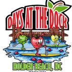
Days at the Docks Festival
April 25th & 26th
Holden Beach
The annual festival which started in the 1980’s occurs in April or May and is sponsored by the Greater Holden Beach Merchants Association. It’s the Holden Beach way to kick-off the Spring and start the vacation season. In addition to the food and arts & crafts, enjoy live music & entertainment, a horseshoe tournament and the world famous “Bopple Race”. Lots of activities for the entire family!
For more information » click here

Strawberry & Wine Fest
April 26th
Sunset Beach
.
The Strawberry and Wine Festival, hosted by theOld Bridge Preservation Society since 2014. There will be wines available from Silver Coast Winery with strawberries as the main fare of the day. It’s a day of wine, food, entertainment, and craft vendors.
For more information » click here

Blue Crab Festival
May 16th & 17th
Little River SC
.
Little River has been celebrating the World Famous Blue Crab Festival since 1981. It is held on the waterfront in Little River and is one of the largest festivals in the Southeast. The purpose of this festival is one that supports and showcases the fabulous atmosphere of the local communities.
For more information » click here

Conway Riverfest Celebration
June 27th
Conway SC
Held along the Waccamaw River in downtown Conway the festival celebrates Independence Day since 1980 with music and events for the entire family.
For more information »click here
 Brunswick County invites residents to participate in lifesaving certification training in 2026
Brunswick County’s Risk Management and Parks and Recreation departments are partnering to offer First Aid/CPR/AED Certification Training in 2026.
This training program is designed to provide residents with the knowledge and skills needed to recognize and respond appropriately to cardiac, breathing and first aid emergencies.
The training is open to any Brunswick County residents 12-years-old and up. Participants under 18-years-old must be accompanied by an adult guardian for the entire training session. Upon successful completion of the course, participants will receive an American Trauma Event Management (ATEM) First Aid/CPR/AED certification card, which is valid for two years.
There are only 12 seats available per training session and the registration fee is $10 per person. Participants must register and pay online here,
https://bcparks.recdesk.com/Community/Program, before the training date.
Each class will consist of an morning Session from 9 a.m. to 12 p.m., a 30-minute lunch break (participants must bring their own lunch and beverages) and an afternoon session from 12:30 p.m. to 3:30 p.m. Attendees must attend and complete both sessions to receive certification.
2026 First Aid/CPR/ AED Certification Training Sessions
Saturday, June 20, 2026 / Supply Area
-
- Location: Lockwood Folly Community Building
• 1691 Stanbury Rd SW, Supply, NC 28462 - Time: 9 a.m. to 3:30 p.m.
- Cost: $10 per person
- Registration opens March 1, 2026
- Location: Lockwood Folly Community Building
For questions or more information about the training program, email Brunswick County Risk Management.
![]() Discover a wide range of things to do in the Brunswick Islands for an experience that goes beyond the beach.
Discover a wide range of things to do in the Brunswick Islands for an experience that goes beyond the beach.
For more information » click here.
Calendar of Events Island
 Concerts on the Coast Series
The Town’s summer concert series calendar has been released! Live performances featuring local musical groups will be held at the Bridgeview Park picnic pavilion across from Town Hall. It will be on Sunday evenings at 6:30pm from May 24th to September 6th. The concerts are free of charge.
Reminders

Pets on the Beach Strand
§90.20 RESPONSIBILITIES OF OWNERS
Effective May 20th through September 10th
-
-
- Pets are not allowed on the beach strand during the hours of 9am through 5pm
- Dog’s need to be on a leash
- Owner’s need to clean up after their animals
-
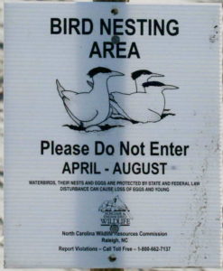
Bird Nesting Area
NC Wildlife Commission has posted signs that say – Bird Nesting Area
The signs are posted on the west end beach strand around 1335 OBW.
People and dogs are supposed to stay out of the area from April through November
. 1) It’s a Plover nesting area
. 2) Allows migrating birds a place to land and rest without being disturbed

A Second Helping
.
Program to collect food Saturday mornings (8:00am to 10:30am) during the summer at the Beach Mart on the Causeway.
1) Twenty-second year of the program
2) Food collections have now exceeded 317,000 pounds
3) Collections will begin on Memorial Day weekend
4) Food is distributed to the needy in Brunswick County
For more information » click here
.
Hunger exists everywhere in this country; join them in the fight to help end hunger in Brunswick County. Cash donations are gratefully accepted. One hundred percent (100%) of these cash donations are used to buy more food. You can be assured that the money will be very well spent.
Mail Donations to:
A Second Helping
% Sharon United Methodist Church
2030 Holden Beach Road
Supply, NC 28462
 Yard Waste Service
Yard debris pick-up will be provided twice a month on the second and fourth Fridays during the months of March, April, and May. Please have yard waste placed at the street for pick-up on Thursday night. The last pickup of the season is on May 22nd. No pick-ups will be made on vacant lots or construction sites.
Debris must be placed in a biodegradable bag or bundled in a length not to exceed five (5) feet and fifty (50) pounds. Each residence is allowed a total of ten (10) items, which can include a combination of bundles of brush and limbs meeting the required length and weight and/ or biodegradable bags with grass clippings, leaves, etc.
 News from Town of Holden Beach
The town sends out emails of events, news, agendas, notifications, and emergency information. If you would like to be added to their mailing list, please go to their web site to complete your subscription to the Holden Beach E-Newsletter.
For more information » click here
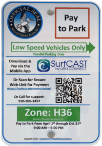 Paid Parking
Paid parking in Holden Beach
Paid parking will be enforced from 9:00 a.m. to 5:00 p.m. daily with free parking before and after that time. All parking will use license plates for verification.
Rates
Parking rates for a single vehicle in all designated areas will be:
$5 per hour for up to four hours
$20 per day for any duration greater than four hours
$80 per week for seven consecutive days
Handicap Parking
A vehicle displaying a handicap license plate and/or hang tag parked in a designated handicap space is free. Any other parking space will require a parking permit via the app.
Annual Passes
Annual permits for the calendar year allow vehicles (this includes low-speed vehicles and trailers) access to designated parking.
$175 for a single vehicle
Passes can be purchased via the app, website or by telephone.
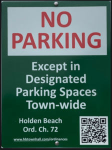
Where to Park
Per ordinance, there is no parking on the streets or rights-of-way except in designated parking spaces identified by Pay-to-Park signs. Click here to view an interactive map. The table with authorized parking can be viewed below.
Citations will be issued for:
-
-
- Parking without an active paid permit in a designated parking area
- Parking within 40 feet of a street intersection
- Parking in a crosswalk, sidewalk, or pedestrian access ways
- Parking blocking a driveway or mailbox
- Parking facing opposing traffic
- Parking in a no parking zone, or within right-of-way
- Parking on any portion of the roadway or travel lane
- Parking a non-LSV vehicle in an authorized LSV location
-
How Do I Pay to Park
The Town uses the SurfCAST by Otto Connect Mobile Solution. This is a mobile app downloadable for Apple and Android devices. Download the app today. Users will setup their account, enter their license plate details and pay for parking directly on the app. Alternatively, users can scan the QR Code located on the parking signs to access a secure website.
The Otto Connect customer service team will be available to help via phone and email.

Solid Waste Pickup Schedule
GFL Environmental change in service, October through May trash pickup will be once a week.
Please note:
Trash carts must be at the street by 6:00 a.m. on the pickup day
BAG the trash before putting it in the cart
Carts will be rolled back to the front of the house
GFL Refuse Collection Policy
GFL has recently notified all Brunswick County residents that they will no longer accept extra bags of refuse outside of the collection cart. This is not a new policy but is stricter enforcement of an existing policy. While in the past GFL drivers would at times make exceptions and take additional bags of refuse, the tremendous growth in housing within Brunswick County makes this practice cost prohibitive and causes drivers to fall behind schedule.
Solid Waste Pickup Schedule
starting the Saturday before Memorial Day (May 23rd) twice a week
Recycling
starting after Memorial Day (June 2nd) weekly pick-up
Curbside Recycling – 2026
GFL Environmental is now offering curbside recycling for Town properties that desire to participate in the service. The service cost per cart is $122.93 annually paid in advance to the Town of Holden Beach. The service consists of a ninety-six (96) gallon cart that is emptied every other week during the months of October – May and weekly during the months of June – September.
Curbside Recycling Application » click here
Curbside Recycling Calendar » click here

Trash Can Requirements – Rental Properties
GFL Environmental – trash can requirements
Ordinance 07-13, Section 50.08
Rental properties have specific number of trashcans based on number of bedrooms.
* One extra trash can per every 2 bedrooms
..
§ 50.08 RENTAL HOMES.
(A) Rental homes, as defined in Chapter 157, that are rented as part of the summer rental season, are subject to high numbers of guests, resulting in abnormally large volumes of trash. This type of occupancy use presents a significantly higher impact than homes not used for summer rentals. In interest of public health and sanitation and environmental concerns, all rental home shall have a minimum of one trash can per two bedrooms. Homes with an odd number of bedrooms shall round up (for examples one to two bedrooms – one trash can; three to four bedrooms – two trash cans; five – six bedrooms – three trash cans, and the like).
Upon Further Review
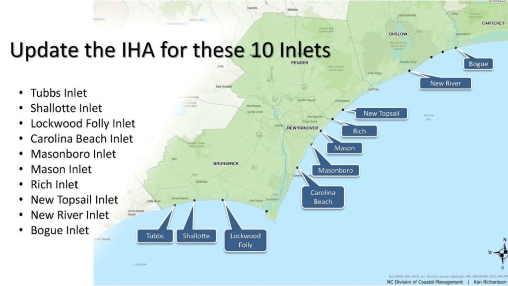
Commission to consider updating inlet hazard areas
The North Carolina Coastal Resources Commission is to meet next week to consider proposed language amendments for inlet hazard areas. The meeting for the commission, which establishes policies for the N.C. Coastal Management Program and adopts rules for both the Coastal Area Management Act and the N.C. Dredge and Fill Act, will begin with a field trip to Ocean Isle Beach’s terminal groin at 3 p.m. on April 15. The full commission meeting is scheduled for 9 a.m. on April 16 at 111 Causeway Drive, Ocean Isle Beach. An in-person public comment period is scheduled for 9:30 a.m. that day. The public may sign up to speak upon arrival at the meeting. Members of the public may attend in-person or join the meeting Thursday through the North Carolina Department of Environmental Quality’s YouTube channel. The commission establishes areas of environmental concern, which are authorized under CAMA, and are the bases of the permitting program for regulating coastal development. There are three types of ocean hazard AECs: ocean erodible, inlet hazard, and unvegetated beach. The ocean erodible area is “the area where there exists a substantial possibility of excessive erosion and significant shoreline fluctuation,” and the inlet hazard area is defined as “locations that ‘are especially vulnerable to erosion, flooding and other adverse effects of sand, wind, and water because of their proximity to dynamic ocean inlets,” according to the division, which carries out the rules and regulations for the commission. During the meeting, the commission will consider ocean erodible area and inlet hazard area erosion rates and setback factors. The division has since 1979 used the same long-term erosion data to determine construction setbacks in inlet and ocean hazard areas, and to establish the landward boundaries of ocean erodible areas of environmental concern. The commission’s setback rules are used to site oceanfront development based on the size of the structure according to the graduated setback provisions. In areas where there is a high rate of erosion, buildings must be located farther from the shoreline than in areas where there is less erosion. The size of the structure determines how far back a house must be located away from the shoreline. Because of limited data and resources, erosion rate setback factors within inlet hazard areas have traditionally been based on the rates of adjacent ocean erodible areas. “Given the rapid changes that can occur at inlets, this method has often resulted in setback factors that underestimate the true erosion dynamics of these areas,” division documents state. During the commission’s August 2025 meeting, Dr. Laura Moore, the chairperson of the commission’s Science Panel on Coastal Hazards, presented the panel’s recommendations on updated boundaries for inlet hazard areas and ocean erodible areas, and their corresponding erosion rate setback factors. A subcommittee was appointed at the time to evaluate the possible changes and presented its recommendation during the February meeting. Updating ocean hazard area boundaries for inlet hazard areas and ocean erodible areas, along with the associated erosion rate setback factors, requires rule amendments to reference the updated report and maps, documents continue. Because inlet hazard area boundaries have remained static and adjacent ocean erodible area erosion rates were applied within the inlet hazard areas, the primary amendment has been to the rule “to simply reference the updated oceanfront erosion rate report. However, this update includes revised IHA boundaries and inlet-specific erosion rates within IHAs, necessitating additional rule amendments to reference the applicable reports, maps, and use standards,” documents explain. Division staff noted that the 2025 study is consistent with previous update studies, in that inlet hazard area boundaries at undeveloped inlets were not analyzed. The commission at this month’s meeting is to consider approving rule amendments that reflect the subcommittee’s findings and recommendations and supported by the Coastal Resources Advisory Council, updated inlet hazard boundaries, and updated ocean erodible areas and inlet hazard areas erosion rate setbacks, to include ocean erodible areas landward boundaries. Division staff are to recommend removing the inlet hazard area designations from Little River Inlet, New River and Brown’s Inlets at Marine Corps Base Camp Lejeune, Bogue Inlet at Hammocks Beach State Park, Barden Inlet, Ocracoke Inlet and Hatteras Inlet. “It is important to note that while inlet hazards are present at these sites, these areas are not being developed,” staff said. In addition, division staff are to present updates on septic systems within the ocean hazard areas of environmental concern, consider draft rule amendments for human-made ditches requested by a petition for rulemaking, and a permit for temporary weather monitoring structures on the beach in the ocean hazard area of environmental concern. The full meeting agenda and briefing materials are on the commission’s website.
Read more » click here
Commission moves forward with inlet hazard area updates
North Carolina’s Coastal Resources Commission is moving through the steps to update rules for building along high-hazard coastlines that are particularly vulnerable to erosion and flooding. When the commission met April 16 in Ocean Isle Beach’s town hall, members voted unanimously to advance the rulemaking process to draft language amendments for ocean erodible areas and inlet hazard areas. Proposed changes include using the most recent data for erosion rates and maps for the two zones, which are classified as areas of environmental concern. If approved, this will be the first time new inlet hazard boundaries have been updated since they were initiated in the late 1970s. The commission has been discussing revisions for decades, but the complicated process and public blowback have pushed talks of updates year to year. Both inlet hazard and ocean erodible areas fall under the ocean hazard areas category of areas of environmental concern, which are the foundation for the Coastal Area Management Act permitting program. CAMA was enacted in 1974, along with the commission to adopt rules for legislation that protects the state’s coastal resources. The Division of Coastal Management, under the North Carolina Department of Environmental Quality, acts as staff to the commission. Inlet hazard areas, or IHAs, encompass land along the narrow body of water that allows for tidal exchange between the ocean and inland waters. These swaths of shoreline are susceptible to inlet migration, rapid and severe erosion, and flooding. Land within the boundaries is subject to the commission’s development rules. Ken Richardson, the division’s shoreline management specialist, told Coastal Review that in addition to the proposed updates to inlet hazard area boundaries, one of the primary changes under consideration is that erosion rate setbacks within inlet hazard areas will be based on inlet-specific erosion rates detailed in a 2025 report rather than the adjacent ocean erodible area, or oceanfront, rates, which is currently the case. Because of limited data and resources, erosion rate setback factors within inlet hazard areas have been based on the rates of adjacent ocean erodible areas, essentially treating the inlet shoreline as an extension of the oceanfront. “Given the rapid changes that can occur at inlets, this method has often resulted in setback factors that underestimate the true erosion dynamics of these areas,” according to the division. Erosion rates are used to determine how far back new construction must be from the shoreline. Richardson said that, “Additionally, the rules would effectively ‘hold the line’ of existing development by preventing seaward expansion of new development in inlet areas that have experienced natural accretion.” He referenced the “Inlet Hazard Area Boundaries, 2025 Update: Science Panel Recommendations to the North Carolina Coastal Resources Commission,” presented in August 2025 to the commission that explains “any accretion at most inlets is temporary and likely to reverse over time; maintaining this line helps reduce future exposure to erosion hazards.” The commission’s Science Panel on Coastal Hazards was directed in 2016 to update IHA boundaries. Rules were in the process of being updated in 2019, but the COVID-19 pandemic paused draft rules from moving forward. The “Science Panel recommended updating IHAs on a five-year cycle alongside oceanfront erosion rates, by the time work resumed after the pandemic, the next oceanfront study (2025) was already approaching. As a result, some stakeholders asked the CRC to proceed with a coordinated update,” leading to the directive in 2023 to provide another five-year review, Richardson told Coastal Review. Richardson explained during the meeting last week that the science panel analyzed for the 2025 update the state’s developed inlets, which are Bogue, New River, New Topsail, Rich, Mason, Masonboro, Carolina Beach, Lockwood Folly, Shallotte and Tubbs. Panel Chair Dr. Laura Moore, professor of coastal geomorphology at the University of North Carolina Chapel Hill, presented the findings in the inlet hazard area boundaries report during the August 2025 meeting. Last February, the Coastal Resources Advisory Council and a subcommittee reviewed the report and suggested deviating from the panel’s recommendation to measure setbacks from the hybrid-vegetation line because of concerns that existing structures would be nonconforming, and therefore harder to replace if something happened to the structure. They decided to base the language on existing rules and continue to measure setbacks within inlet hazard areas from the actual vegetation line or pre-project line but not extend farther oceanward than the footprint of an existing structure, or, in the case with vacant lots, the landward-most adjacent neighboring structure, according to the division. Richardson told the commission that another recommendation included amending the language for ocean erodible areas language citing the 2019 report to the “North Carolina 2025 Oceanfront Setback Factors & Long-Term Average Annual Erosion Rate Update Study: Methods Report.” Richardson noted that there are no boundary maps for ocean erodible areas because boundaries are measured from the vegetation line, which are dynamic and could change overnight, so the landward boundary is determined in the field. Staff also proposes eliminating the distinction of residential or nonresidential for the type of structure, because “It doesn’t matter to erosion what the structure is being used for,” Richardson said. Now, the proposed rule changes will go through the fiscal analysis. This step in the rulemaking process determines the financial impact of the proposed amendments. After the analysis is presented and voted on, the commission will decide to move on to the public comment period, then to final approval before sending it to the Rules Review Commission.
Septic tank update
Cameron Luck, a policy analyst for the division, briefed the commission on the work to develop rules for septic system siting, repair and replacement within ocean hazard areas. He began by sharing what took place during a meeting March 30 in Buxton coordinated by the North Carolina Coastal Federation, with representatives from the North Carolina Home Builders Association, North Carolina Septic Tank Association, Outer Bank Association of Realtors, National Park Service, and from county health departments. Attendees were brought up to speed on some of the issues surrounding failed septic tanks on the oceanfront, heard from Cape Hatteras National Seashore representatives about their policies and ongoing struggles and efforts to address both the threatened oceanfront structures and the failed septic tank systems and systems out on the beach Department of Health and Human Services provided a quick synopsis of their process, focusing on the role within and alongside local health departments, with a discussion on how the department permits and cites septic tanks and how and failure enforcement. Luck said that he and other division staff presented the most recently proposed rule language for discussion. “We spent a good amount of time talking through the proposed language and some areas that could be improved,” Luck said. Main points in the discussion focused on defining what type of repair would qualify for a permit. “In other words,” Luck explained, would property owners be required to secure a permit if a filter or a section of pipe needs to be replaced, or does the rule need to be more focused on extreme failures. Discussion also focused on whether the proposed rule changes should be applied coastwide or be more targeted to specific situations or locations. “Perhaps, key takeaway from that meeting was a clear consensus among those attendees that some form of action is needed to limit the repair of failed septic systems on the ocean beach and to prevent them from remaining on the beach once they failed,” he said, adding that staff is working on those rule language updates.
Read more » click here
CRC approves draft inlet development rule changes
The Coastal Resources Commission (CRC) has approved draft rules that would update how the state regulates development near coastal inlets in Brunswick County. The commission voted unanimously April 15 to move forward with the proposed changes, which include updates inlet hazard area (IHA) maps, new erosion rate data and revised setback requirements. The vote does not finalize the rules but begins the formal rulemaking process that will include fiscal analysis, public hearings, additional review and an adoption vote before any changes would take effect, Department of Coastal Management Shoreline Management Specialist Ken Richardson said. The CRC has been working on these proposed rule amendments since August and has focused most on the IHA boundaries. IHAs define the most dynamic and erosion-prone parts of barrier islands near inlets, where development is subject to stricter regulations — mainly setback factors. The current IHA maps date back to 1979 and were originally intended to be updated more regularly, Richardson said. The new rules are based on data presented by the CRC’s science panel, which published a report last summer proposing new inlet hazard area boundaries for each inlet in Brunswick County. In Ocean Isle Beach (OIB), the number of structures within the IHA would jump from 41 to 230. In Holden Beach, the number would increase from 63 to 186. Sunset Beach, however, would see a decrease from 206 to just 17, Richardson said. The proposed changes would divide some inlet areas into multiple sections with varying setback factors. Setback factors are based on erosion rates, and they determine how far structures must be built or rebuilt from the vegetation line. The vegetation line is the line between the dry sand on the beach and the dune vegetation.
Here’s how the current setback factors would change:
-
- Setback factors in Sunset Beach’s IHA at Tubbs Inlet would not change. They are two.
- The OIB IHA at Tubbs Inlet would be split into two sections with setback factors of 10 and two.
- The OIB IHA at Shallotte Inlet would be split into eight sections with setback factors ranging from 2 to 17.5.
- Setback factors in the Holden Beach IHA at Shallotte Inlet would largely remain at two except for two small sections on the northern bend that would increase to nine and 16.
- The Holden Beach IHA at Lockwood Folly Inlet setback factors would decrease. Two sections would have setback factors of two and five.
Alongside the boundary updates, the CRC is also proposing to adopt a study that recalculates long-term erosion rates for Brunswick County shorelines. Those rates are used to define ocean-erodible areas (OEA), where additional development restrictions apply. The updated erosion data would not change setback factors in any OEAs on Brunswick County’s beaches, according to the study. However, the proposed changes would significantly change how many properties fall within IHAs in Brunswick County, and some inlets would see high increases in setback factors. The east end of OIB would see the most drastic change in numbers. The CRC took a field trip to this area on April 14, where OIB’s terminal groin sits. The terminal groin, completed in 2022, is a jetty structure made of large rocks that juts out into the ocean on OIB’s east end. “The inlet where we were at yesterday,” Richardson said, “that’s going to be one of the places where you’re going to see the most significant impact in terms of how erosion rates are applied.” During the 2025 hurricane season, the east end of OIB partially washed away. Erosion threatened homes in The Pointe OIB subdivision and collapsed a portion of its culdesac, Grand View Drive. This area would see sharp required setback increases under the new rules. During the field trip, the group stood at the base of the terminal groin as it heard from representatives of the engineering firm the town of OIB hired to design the terminal groin. Some CRC commissioners questioned what was causing such extreme erosion just east of the terminal groin, and whether it was the terminal groin itself. Coastal Protection Engineering’s Senior Marine Biologist Brad Rosov said he believes that it is impossible to pinpoint one factor as the cause of erosion on any barrier island. Just west of the terminal groin, sand from a 2022 beach renourishment project remains in front of homes that used to have ocean water underneath them at high tide, he noted. Mayor Debbie Smith explained that sandbags still remain beneath the budding dunes in front of those homes behind the terminal groin. Those sandbags used to be the only wall of protection. Now, the terminal groin appears to be protecting those homes, while The Pointe OIB stands behind a wall of sandbags waiting for renourishment. Jimmy Bell, a representative of The Pointe OIB community, spoke during the public comment period at the beginning of the April 15 meeting. He inquired about the financial implications that the updated setback requirements would have on existing homes and undeveloped lots in the proposed IHAs. The proposed rules include provisions allowing existing structures that become nonconforming to be rebuilt under certain conditions. Property owners would be allowed to replace damaged or destroyed structures as long as the new building does not exceed the original footprint or square footage, meets the required setback and is placed as far landward on the lot as feasible, Richardson said. For undeveloped lots within IHAs, new construction would be limited to a line no farther seaward than the landward most adjacent neighboring structure and must be as landward as feasible. Richardson said the intent of the “grandfathering” rules is to prevent incremental encroachment toward the ocean in areas that may temporarily gain sand but be expected to erode again. Questions remain about how the proposed changes could affect specific areas and property owners. The next step in the approval process is the fiscal analysis, which will likely come back before the CRC for approval in August. After that is approved, the CRC would hold a public hearing in Brunswick County, Richardson said.
Read more » click here
Hot Button Items / Inlet Hazard Areas
For more information » click here
Fuquay-Varina Interbasin Transfer
Previously reported – December 2025
Resolution 25-11 » click here
ISSUE/ACTION REQUESTED:
Discussion and Possible Approval of Resolution 25-11, Resolution Opposing the Fuquay-Varina Interbasin Transfer and Request for Additional Comment
BACKGROUND/PURPOSE OF REQUEST:
Representatives from the Lower Cape Fear Water and Sewer Authority (LCFWASA) distributed a draft resolution opposing the Fuquay-Varina Interbasin Transfer (IBT) and requesting additional comment. The resolution outlines concerns regarding the Town of Fuquay-Varina ‘s proposal to transfer water from the Cape Fear River Basin to the Neuse River Basin and it requests additional time and opportunities for the impacted Cape Fear Basin communities to review and provide input on the proposed transfer.
Given the potential regional impacts to water availability and future growth, LCFWASA is asking local governing bodies to consider adopting a similar resolution to support this effort.
TOWN MANAGER’S RECOMMENDATION:
Recommend approval of resolution opposing the Fuquay-Varina lnterbasin Transfer (IBT) and request for additional comment.
Interbasin Transfer
The Town of Fuquay-Varina has partnered with the City of Sanford to purchase up to 6 million gallons per day (mgd) of finished water from the City to meet the Town’s water supply needs over a 30-year planning period. Finished water will be transferred from the Cape Fear River basin (Lee County) to the Neuse River basin (Wake County). An interbasin transfer is defined as the regulated movement of surface water from one river basin to another. Law does not prohibit transfers but requires that effects of the transfer on the source and receiving basins be quantified prior to the transfer.
The proposed water balance and interbasin transfer (IBT) meet the statutory definition of a transfer per General Statutes 143-215.22G and 215.22L, therefore the Town of Fuquay-Varina must prepare an Environmental Impact Statement, conduct Public Hearings, and submit a petition to the Environmental Management Commission for the IBT Certificate. The process is anticipated to take three to five years.
Update –
It’s plain and simple, we oppose the water transfer as requested since it will be taking away water from us. Given the potential regional impacts to water availability and future growth, Lower Cape Fear Water and Sewer Authority (LCFWASA) is asking local governing bodies to consider adopting a similar resolution to support opposing the Fuquay-Varina lnterbasin Transfer (IBT) and request for additional comment.
A decision was made – Approved unanimously
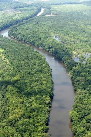
Fight over Cape Fear River water sparks widespread downstream anger
A fast-growing suburb near Raleigh wants to take water from the Cape Fear and then dump it into the Neuse River basin. Downstream users are saying not so fast.
For most of its nearly 190-mile journey through Central and Southeastern North Carolina, the murky Cape Fear River flows slowly and peacefully through a relatively flat landscape as it makes its way from the Piedmont to the coast. But over the past few weeks the river’s waters have been anything but tranquil as local government officials, environmentalists, concerned citizens and regulators tussle over plans by one Triangle community to take water from the river basin to meet the needs of a booming population. While withdrawing water from a river basin isn’t uncommon in North Carolina, it’s what Fuquay-Varina wants to do with the water after its been through the town’s utility systems and used by homes and businesses that’s generating concerns.
What’s the issue?
Fuquay-Varina in Wake County is proposing to partner with Sanford in nearby Lee County to draw up to 6 million gallons per day − enough to fill nine Olympic-sized swimming pools − from the Cape Fear River over the next 30 years to meet its growing population. According to the N.C. Office of State Budget and Management, Fuquay-Varina’s population in 2020 was 34,000, and the town added another estimated 12,000 people by the end of 2024. That figure could reach 100,000 by 2050. But while the water will be drawn from the Cape Fear River near Sanford, it will dumped as wastewater into the Neuse River basin in Wake County. “An interbasin transfer is defined as the regulated movement of surface water from one river basin to another,” according to a post on Fuquay-Varina’s website. “Law does not prohibit transfers but requires that effects of the transfer on the source and receiving basins be quantified prior to the transfer.” Right now Fuquay-Varina gets its water from Raleigh and Harnett and Johnston counties. “Long-term water supply solution from current water purveyors is not feasible,” the town stated in a PowerPoint presentation. According to the project’s draft environmental impact statement (EIS), it would be about $200 million cheaper to take the water from the Cape Fear and release it into the Neuse than to send it back into the Cape Fear River basin.
Water supply, environmental concerns
But downstream communities that rely on the Cape Fear for their drinking water needs, including Fayetteville, Wilmington and much of Brunswick County, have raised a host of concerns about the proposal. At a series of meetings earlier this month in Fayetteville and around the Triangle, dozens of people spoke out passionately and many angrily against the proposed water transfer. Opponents’ arguments included concerns over lower water flows in the Cape Fear, especially during periods of extended drought − something that’s expected to occur more frequently thanks to climate change, which could impact downstream utilities from meeting the water needs of their own growing populations. Several speakers also expressed worries that reduced flows could harm potential economic opportunities, especially if a steady flow of water can’t be guaranteed. Roger Shew, an environmental scientist with the University of North Carolina Wilmington, said lower water flows − something that’s happened four times in the Lower Cape Fear since 2000 and prompted water conservation measures twice − also can have significant environmental impacts. That includes potentially harming migratory fish species, some endangered like the pair of sturgeon species found in the river, which require sustained water levels to successfully breed. Reduced water flows also increase the chance for harmful algal blooms and could increase contamination levels in raw water drawn from the Cape Fear, not to mention the ongoing concerns over “forever chemicals” like GenX found in the waterway. Nearly two dozen local governments, utility authorities, environmental groups, and business organizations have passed resolutions opposing the proposed interbasin transfer.
What happens now?
Shew said North Carolina isn’t a stranger to interbasin transfers, and many of the state’s fast-growing metros and counties have implemented them in one form or another. But he said concerns over the long-term impacts of taking water from one basin and dumping back into another one prompted the N.C. General Assembly this year to adopt a moratorium on new water transfers until March 2027. The ban, however, only covers interbasin transfers of 15 million gallons per day or greater. Fuquay-Varina’s proposal is only for a daily transfer of 6.17 million gallons. But Shew said with so little data on the long-term effects of these water movements, they should be carefully scrutinized no matter what their proposed size. “Hopefully the (N.C. Environmental Management Commission) and (N.C. Department of Environmental Quality) will scrutinize these types of transfers to ensure that no negative impacts occur with this proposal or others,” he said. “And the only way to guarantee that is to keep the water in the basin.” At the least, Shew and others have said the state should hold a public hearing on the proposal in the Lower Cape Fear region where Wilmington-area officials and residents can have their say without having to drive two hours inland to air their concerns. “The draft EIS acknowledges that pollution, reduced flows, increased wastewater discharge, stormwater runoff, and flooding currently threaten the Cape Fear River, and these threats may be exacerbated with the (interbasin transfer),” states a Dec. 5 letter the Southern Environmental Law Center, which is representing a slew of environmental groups opposed to the proposal, sent to state regulators. “In sum, we request that DEQ and the EMC schedule a public hearing on the draft EIS for the Fuquay Varina IBT certificate in or around Wilmington to give communities downstream of the transfer point a full opportunity to participate in the public process on this important issue.” As of publication time no additional public hearings had been scheduled. But the state has extended the window to accept written comments until April 1. They can be mailed to Maya Holcomb, Division of Water Resources, 512 N. Salisbury St., Raleigh, N.C., 27604, or by email to maya.holcomb@deq.nc.gov.
Read more » click here
Previously reported – March 2026
ISSUE/ACTION REQUESTED:
Discussion and Possible Action to Grant Permission to the Mayor of Manager to Sign a Letter in Opposition of the Town of Fuquay-Varina’s Interbasin Transfer Request
BACKGROUND/PURPOSE OF REQUEST:
The Board approved Resolution 25-11, Opposing the Fuquay-Varina Interbasin Transfer (IBT) and Request For Additional Comment in December. Our resolution, in additional to multiple others were hand-delivered by the Cape Fear Council of Governments (COG) to the Environmental Management Commission. A group of working professionals has been assembled to develop a follow-up response in the form of a letter that will discuss specific points related to water quality, water quantity impacts of the proposed IBT, several flaws with the environmental study and flaws in the decision-making process for IBTs. Allen Serkin from the COG is requesting that local governments grant permission to the mayor or manager to sign the letter on behalf of the Board once it is completed.
TOWN MANAGER’S RECOMMENDATION:
Grant permission to the mayor and/or manager to sign the letter in order to meet the submittal deadline of April 1st.
Public comments regarding river basin transfer plan pour in
It’s been nearly a month since a video first aired of Wilmington’s mayor invoking residents to voice their opposition to one town’s plans to pull millions of gallons of water daily from the Cape Fear River. “Today this vital resource is under threat from growing water-hungry communities upstream,” Mayor Bill Saffo says in the clip as he stands along the city’s downtown Riverwalk. Fuquay-Varina, a town about 30 miles south of Raleigh, wants to move more than 6 million gallons of water each day from the Cape Fear River to the Neuse River, he explains in the video made in collaboration with the Cape Fear Public Utility Authority. “That’s 6 million gallons gone, each day, forever. It is important that you make your voice heard now for your family and for future generations. Add your voice to those of your neighbors and friends who already are telling the state to say no to Fuquay-Varina’s permanent taking of our water,” Saffo concludes. Only a couple of more weeks are left until the public comment period on Fuquay-Varina’s request for an interbasin transfer, or IBT, certificate closes. Maya Holcomb, a Division of Water Resources representative, told members of the state Environmental Management Commission’s Water Allocation Committee last week that she anticipated receiving comments all the way through to the April 1 deadline. In her presentation to the committee Thursday, Holcomb provided an update on the numbers of correspondence she’d received in the days since she initially crafted her report, when the email count was at 283. “But I just keep getting so many emails, which — we’re hearing from the public, that’s great — but I have received an additional 42 emails since this PowerPoint was created last week,” Holcomb said. Holcomb said she had also received 41 resolutions from cities, towns, counties, homebuilders, substations and public utilities. She did not say how many of those resolutions oppose the IBT but instead highlighted what she described as the “newest” issues of concern: loss of water for agricultural purposes, nutrient concentration in the Neuse River Basin, such as those that cause algal blooms, per- and polyfluoroalkyl substances, hypoxia, drought vulnerability and chemical export of industrial pollutants from the Cape Fear River. Those concerns mirror some of arguments made by dozens of people who spoke out against the transfer during a series of state-hosted public hearings in December. Fuquay-Varina projects that the water supply, from which it currently buys from Raleigh and Harnett and Johnston counties, will fall short of demand by 2030. Under the proposed preferred alternative identified in a draft environmental impact statement for the transfer, Fuquay-Varina would source its entire water supply from a water treatment plant in Sanford, which is in the Cape Fear River Basin. Once water pulled from the Cape Fear River is used by residents and businesses in that town, the treated wastewater would then be discharged into the Neuse River Basin. This would permanently subtract 6.17 million gallons each day from the river flow that currently serves about 900,000 residents of counties, cities, towns and communities from Fayetteville to Wilmington. “Put in perspective, 6.17 (million gallons per day) of raw water from the river is enough to provide treated drinking water to more than 27,000 homes,” according to Cape Fear Public Utility Authority’s website. In the weeks and months leading up to CFPUA’s campaign against Fuquay-Varina’s plan, several local governments and utilities adopted resolutions and sent letters of opposition to the state. New Hanover County, Wilmington and Brunswick County and more than a dozen Brunswick County municipalities have officially gone on record opposing Fuquay-Varina’s request. Holcomb explained last week that, after April 1, state environmental officials will respond to comments on the draft environmental impact statement and then formulate a hearing officers’ report, which will be finalized sometime between July and September. After that, the Environmental Management Commission will determine whether the EIS is technically adequate. Following that determination, the Department of Environmental Quality will issue its record of decision. Another round of public hearings will be held before the EMC makes its final determination. If approved, the transfer would occur after 2031, according to the draft impact statement. Comments may be submitted to Maya Holcomb, Division of Water Resources, 512 N. Salisbury St., Raleigh, NC, 27604, or by email to maya.holcomb@deq.nc.gov.
Read more » click here
Update –
The Board authorized the Mayor and Town Manager to sign a letter expressing opposition to the Town of Fuquay-Varina’s Interbasin Transfer Request.
A decision was made – Approved unanimously
Wilmington officials, residents fight plan to take water from Cape Fear
Wilmington and other communities oppose a Raleigh suburb’s plan to take 6 million gallons a day from the Cape Fear and return it to the Neuse River.
In the short video, Wilmington Mayor Bill Saffo doesn’t hold any punches. “Our region’s drinking water is under threat,” he says while standing on the city’s downtown Riverwalk with the Cape Fear River in the background. “Say no to the permanent taking of our water.” What prompted the city, in conjunction with the Cape Fear Public Utility Authority, to make the video in mid-February 2026 is a proposal by a fast-growing Raleigh suburb to draw water from the Cape Fear River to meet its growing drinking water demands. In the video, Saffo asks Port City residents to “add your voice to those of your neighbors and friends who already told the state to say no to Fuquay-Varina’s permanent taking of our water.”
A need for additional water
While withdrawing water from a river basin isn’t uncommon in North Carolina, it’s what Fuquay-Varina wants to do with the water after its been through the town’s utility systems and used by homes and businesses that’s generating concerns. Fuquay-Varina in Wake County is proposing to partner with Sanford in nearby Lee County to draw up to 6 million gallons per day − enough to fill nine Olympic-sized swimming pools − from the Cape Fear River over the next 30 years to meet its growing population. But while the water will be drawn from the Cape Fear River near Sanford, it will dumped as wastewater into the Neuse River basin in Wake County. “An interbasin transfer is defined as the regulated movement of surface water from one river basin to another,” according to a post on Fuquay-Varina’s website. “Law does not prohibit transfers but requires that effects of the transfer on the source and receiving basins be quantified prior to the transfer.” Right now Fuquay-Varina gets its water from Raleigh and Harnett and Johnston counties. “Long-term water supply solution from current water purveyors is not feasible,” the town stated in a PowerPoint presentation. According to the N.C. Office of State Budget and Management, Fuquay-Varina’s population in 2020 was 34,000, and the town added another estimated 12,000 people by the end of 2024. That figure could reach 100,000 by 2050. But Wilmington-area officials say they have to worry about meeting the water-hungry needs of their own fast-growing populations, too. The population of New Hanover, Brunswick and Pender counties was estimated to be 482,000 in 2024. That number is expected to be more than 743,000 by 2050. According to the project’s draft environmental impact statement (EIS) submitted by Fuquay-Varina, it would be about $200 million cheaper to take the water from the Cape Fear and release it into the Neuse than to send it back into the Cape Fear River basin. But Saffo and others argue that this issue is about more than just the cost of a utility project. “That’s 6 million gallons gone each day forever,” Saffo says in the video.
‘A growing issue for us’
Downstream communities that rely on the Cape Fear for their drinking water needs, including Fayetteville, Wilmington and much of Brunswick County, have raised a host of concerns about the proposal. They include diminished water flows that could exasperate drought conditions − a growing concern as climate change warms the planet, increased chances of algal blooms, reduced economic opportunities if governments can guarantee a steady flow of water, harm to endangered migratory fish species, and what increased low-flow levels could mean for the presence of “forever chemicals” like GenX in the river basin. More than two dozen local governments, utility authorities, environmental groups, and business organizations have passed resolutions opposing the proposed interbasin transfer. “If we are to have sustainable long-term growth in North Carolina, our communities must exist within the carrying capacity of their natural systems and return any drawn water to the originating watershed,” the Southern Environmental Law Center, which is representing several environmental groups, said it comments submitted to the state. “And our communities must bear their fair share of costs associated with growth and development.” State Rep. Deb Butler, D-Wilmington, said everyone she’s talked to locally is united in the belief that Fuquay-Varina’s plan would be bad for the region and bad for the future health of the river. They also fear that the town’s proposed water grab could be the first of several facing the Cape Fear River basin as local governments in central North Carolina look for ways to meet the needs of their burgeoning populations. “It’s going to become a growing issue for us because we’re at the proverbial end of the line,” Butler said, referring to the Wilmington area sitting near the end of the river’s trek from the Piedmont to the Atlantic. “We need to draw those lines in the sand now because yes, we do want to be good neighbors, but you’ve got to put it back from where you got it.” Lingering concerns over the long-term impacts of taking water from one basin and dumping back into another one prompted the N.C. General Assembly in 2025 to adopt a moratorium on new water transfers. But that ban expires in March 2027. Fuquay-Varina is proposing to start taking water from the Cape Fear sometime after 2031.
More public hearings planned
The window for public comments of the interbasin transfer closed April 1, 2026. State officials will now respond to the comments they received and prepare a report, likely to be finished by late summer. The N.C. Environmental Management Commission will then review Fuquay-Varina’s draft environmental impact statement, with the state making a final decision sometime after that. An additional slate of public hearings is required before any final decision is made.
Read more » click here
 Powerful NC senators oppose proposed Cape Fear River water diversion
A Raleigh suburb wants to take water from the Cape Fear River and return it to the Neuse River basin. Wilmington politicians say not so fast.
Two powerful Wilmington-area legislators have added their voices to the chorus of opposition over a proposal by a Raleigh suburb to remove water from the Cape Fear River basin. State Sens. Michael Lee, R-New Hanover, and Bill Rabon, R-Brunswick, arguably among the most influential politicians in Raleigh, joined other colleagues that represent the river basin in “firm opposition” to the proposal by Fuquay-Varina to draw millions of gallons of water a day from the Cape Fear and then release it into the adjacent Neuse River basin. “This proposed transfer, if approved as submitted, would inflict lasting harm on the water supply, water quality, ecological health, and economic prospects of the people we represent,” states the March 31, 2026, letter submitted to the N.C. Environmental Management Commission. Fuquay-Varina in Wake County is proposing to partner with Sanford in nearby Lee County to draw up to 6 million gallons per day − enough to provide drinking water to more than 27,000 homes, according to the Cape Fear Public Utility Authority − from the Cape Fear River over the next 30 years to meet its growing population. While that’s not a major concern for downstream communities that also rely on the Cape Fear for their drinking water needs, it’s what Fuquay-Varina wants to do with the water after its been used by its residents and businesses that has raised numerous red flags. The town, which could see its population double to more than 100,000 by 2050, wants to release the water after its been treated into the Neuse River basin, not return it to the Cape Fear. According to the project’s draft environmental impact statement (EIS) submitted by Fuquay-Varina, it would be about $200 million cheaper to take the water from the Cape Fear and release it into the Neuse than to send it back into the Cape Fear River basin.
Economic, environmental concerns
But officials, environmental groups, and increasingly residents in Southeastern North Carolina that see the Cape Fear River as a vital environmental and economic resource have called this unacceptable. Along with worries about their own future drinking water needs, concerns that have been raised include diminished water flows that could exasperate drought conditions − a growing concern as climate change warms the planet; increased chances of algal blooms; reduced economic opportunities if governments can guarantee a steady flow of water; harm to endangered migratory fish species; and what increased low-flow levels could mean for the presence of “forever chemicals” like GenX in the river basin. Among the communities and groups that rely on the Cape Fear for their drinking water, serving more than 500,000 customers, are Wilmington, Fayetteville, Brunswick County, Pender County, and Fort Bragg. Numerous agricultural users and other industries also use the river water for a variety of purposes, ranging from irrigation to cooling to an input in their manufacturing processes. Officials also are pouring cold water on Fuquay-Varina’s argument that returning the water back to the Cape Fear could place an undue financial burden on its customers. They state that placing financial needs as the primary driver of approving an inter-basin river transfer could set a dangerous precedent − especially as pressure for the state’s finite water resources will only keep growing in future decades as North Carolina’s population continues to increase. “The recognized best practice for municipalities that draw water from a shared resource like the Cape Fear is to return that water to the same basin after treatment,” states the politicians’ letter to the environmental commission. “This principle should not be abandoned to accommodate the budgetary preferences of a single applicant.”
Review underway
Along with Lee and Rabon, also signing the letter were state Sens. Brent Jackson, R-Bladen, Val Applewhite, D-Cumberland, Tom McInnis, R-Cumberland, and Danny Britt Jr., R-Hoke. The window for public comments on the proposed inter-basin transfer closed April 1, 2026. State officials will now respond to the comments they received and prepare a report, likely to be finished by late summer. The state environmental commission will then review Fuquay-Varina’s draft environmental impact statement, with the state making a final decision sometime after that. An additional slate of public hearings is required before any final decision is made.
Read more » click here
Corrections & Amplifications
 Carolina Bays Parkway project S.C. 31
Public sways officials to ax parkway plan’s preferred NC route
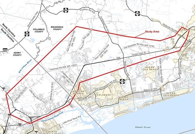
The North Carolina Department of Transportation announced Wednesday that its officials are considering new design options for the Carolina Bays Parkway Extension project in Brunswick County after feedback from the public. NCDOT, in collaboration with the South Carolina Department of Transportation, is planning to extend S.C. Highway 31, aka the Carolina Bays Parkway, from S.C. Highway 9 in Horry County across the state line to U.S. Highway 17 in Brunswick County. Proposed is a multilane highway that would use portions of the existing road in addition to building roadway in new areas. The total anticipated cost for the project is $797 million. North Carolina’s share of the cost is estimated at $610.9 million. South Carolina anticipates construction commencing in 2029. North Carolina’s start date was listed as “TBD” on the project website. In October 2025, the state highway departments jointly held two public hearings about the project. Seven different design alternatives were presented, including the departments’ preferred alternative known as Alternative 4. NCDOT said Wednesday that, after reviewing public feedback and considering funding challenges, it’s not going to proceed with the North Carolina portion of Alternative 4, which builds on new location, tying in near the intersection of U.S. 17 and N.C. Highway 904. Alternative 4 would also upgrade part of U.S. 17 to a fully controlled freeway from N.C. 904 to N.C. Highway 130 in Shallotte. The two state agencies and the Federal Highway Administration continue to collaborate and explore other alternatives and modified routes to minimize impacts and meet the purpose and need of the project, according to NCDOT’s announcement. “NCDOT deeply values the input from this community and our stakeholders. We want to provide the region with the best possible roadway designs. We’ve listened to the feedback, and we’re working hard to prepare a new alternative,” said Division 3 Engineer Trevor Carroll in a statement. Alternative 4 was preferred because of factors such as requiring the lowest number of residential displacements, estimated at 39, and the lowest number of identified noise effects. The impacts to wetlands and streams were also deemed moderate relative to other alternatives, despite a large amount of designated High-Quality Waters impacted. A new alternative must include connectivity through the transportation network, increased mobility for the region and reduced travel time through the project corridor, officials noted in the announcement. Additional information regarding the new design is to be presented to the public at a later date. NCDOT said it is “committed to transparency, innovative solutions and exploring community feedback regarding this project.” Its response to all comments received is available on the project webpage along with the most updated information regarding the project. You can also follow NCDOT on social media for additional updates.
Read more » click here
Previously reported – February 2025
Study analyzes tolling proposed Carolina Bays Parkway Extension
Findings from a state tolling analysis indicate the proposed Carolina Bays Parkway Extension into Brunswick County wouldn’t generate enough traffic and revenue to significantly reduce the cost of the estimated $800 million project. The North Carolina Turnpike Authority analyzed the feasibility of tolling the highway project that would connect North and South Carolina, potentially providing a quicker route between Wilmington and Myrtle Beach. “This project will help alleviate congestion,” said David Roy, who oversaw the study. “But the volumes on the new location, from a tolling perspective, just weren’t gonna be sufficient.” The study found that tolls could generate several million dollars annually by 2045. However, Roy said that revenue would only cover regular road maintenance. “Analysis shows the project would be unlikely to generate sufficient revenues to reduce the cost of construction to the State as a result of tolling under any of the scenarios analyzed,” the study says. “NCDOT and NCTA are not advocating for a particular path forward.” The analysis examined three scenarios for the parkway extension. The first phase would connect the Carolinas to Ash Little River Road, north of Route 17. There are two options for the second phase: a shorter connection eventually linking to Route 17 near Grissettown or a longer option extending to Shallotte. The longer option would generate the most revenue if tolled, the study found. “In any of those three scenarios…none of them showed significant revenue,” Roy said. The proposed project has drawn opposition from Brunswick County residents. Several hundred people attended a public hearing in Sunset Beach in October, with many expressing concerns about traffic, cost and environmental impacts. Adding a toll would likely generate further frustration, but Roy said tolls aren’t always the answer for funding. “It’s not the right solution for every project, and it really does require significant volume before, I think, it starts to make sense,” he said. Transportation leaders on both sides of the state line must now determine how to fund the project. Alternative funding options, beyond a toll, include a sales tax, bond or state appropriation. North Carolina, where most of the construction would take place, would be responsible for about $610 million of the $797 million cost. Construction is scheduled to begin in 2028, with completion timelines varying based on which scenario moves forward. In the study, the first phase was assumed to open in 2035, with the second phase in 2040. Roy said the project has also been submitted as a toll project in the latest NCDOT Prioritization round, where it’ll receive a score that could impact future funding decisions.
Read more » click here
Toll study sheds new light on major Brunswick road project
A new study reveals what tolling a new highway connecting North and South Carolina would actually look like for Brunswick County. After years of waiting, the Carolina Bays Parkway Extension project is slowly picking up speed and costs. The North Carolina Turnpike Authority has presented a tolling analysis for the project as one local transportation organization continues its search for funding opportunities to move the road off paper, and onto dirt. The North Carolina and South Carolina departments of transportation and Federal Highway Administration are working together to extend S.C. 31, known as Carolina Bays Parkway, from S.C. 9 in Horry County, South Carolina, to U.S. 17 in Brunswick County. If funded and constructed, the proposed project will result in a new multi-lane full access freeway connecting the Carolinas. Alternative map 4, which crosses through Hickmans Crossroads and the Longwood area, as the preferred route in Brunswick County that will eventually dump onto U.S. 17. All seven of NCDOT’s alternative maps for preferred routes can be viewed on NCDOT’s website. In June 2025, the Grand Strand Area Transportation Study Metropolitan Planning Organization Transportation Advisory Committee, comprised of Brunswick County leaders, passed a resolution requesting NCDOT conduct a feasibility study to consider tolling the Carolina Bays Parkway Extension project. The resolution also recognized other funding sources will need to be explored. Here’s a look at what the toll study includes and potential revenue that could come if the new highway is built and tolled.
Analysis data and current traffic counts
The StarNews obtained the Carolina Bays Parkway tolling analysis presentation, made by David Roy with the North Carolina Turnpike Authority. The study analyzed three scenarios based off alternative map 4 and 4A and included a “sketch level” traffic and revenue forecast for the project from Stantec. Phase one, projected to open in 2035, is constructing the highway from the state line to Ash Little River Road. Phase two included two scenarios, either could open in 2040. One phase two scenario continues the route from Ash Little River Road to N.C. 904, the other scenario stretching the route to the U.S. 17 Shallotte Bypass/N.C. 130 area. Like other state turnpike authority projects, as stated in the presentation, the project was modeled using an electronic toll collection/bill by mail tolling structure. The analysis used data collected 2023-2025 traffic counts from the NCDOT, NCTA and SCDOT. In 2024, S.C. 31 south of S.C. 9 East in South Carolina had an annual average daily traffic count of 37,000 and U.S. 17 near the state line had an approximate 19,000 annual average daily traffic count, per the presentation. The annual average daily traffic count west of N.C. 904 on U.S. 17 in 2025 was just under 32,000 in 2025.
Estimated revenue from tolling Carolina Bays Parkway extension
If phase one were to open in 2035, the study calculated the road having 630,000 transactions the first year and 1.1 million transactions by 2040. That would bring a net revenue of $500,000 to $860,000 each year for the first five years. Continuing the route from Ash Little River Road to N.C. 904 could climb the number of yearly transactions to 4.3 million in 2040 and 6.8 million in 2045. If built, this could generate $3.9-6.2 million in annual net revenue, according to the presentation. The highest revenue-generating route, from the study, would be building the highway from the state line to Ash Little River Road to the U.S. 17 Shallotte Bypass/N.C. 130 area. The study calculated this route could produce a total of $1170 million in revenue from 2035-2085. If completely built to this route, the lifecycle operations and maintenance are anticipated to cost around $660 million, with an additional $410 million in major road maintenance.

The NCDOT website, updated Nov. 21, has the total projected cost at $797 million, over $200 million more than the previous cost estimate. North Carolina’s portion is expected to cost $610.9 million, and the anticipated start date is 2028, per the website. A completion date has not been determined. The NCDOT portion of the project is only funded for preliminary engineering, NCDOT representatives previously told the StarNews, but not for right-of-way, utilities or construction. Despite the project anticipated to bring millions of dollars over the years, the analysis shows tolling the road could only support operations and maintenance costs, not create enough revenue to support construction funding through a “toll revenue supported debt.” A toll revenue bond is an example of a toll revenue supported debt. “Analysis shows the project would be unlikely to generate sufficient revenues to reduce the cost of construction to the state as a result of tolling under any of the scenarios analyzed,” the presentation states. The presentation notes the NCDOT and NCTA will continue supporting the organization but are not advocating for a specific path forward. The highway extension project has also been submitted as a toll project in the NCDOT Prioritization 8.0 process.
Read more » click here
Previously reported – June 2025
To fast-track highway extension into Brunswick, leaders push for toll study
A toll could be the only way to fund a new highway connecting North and South Carolina. After years of waiting, one local transportation organization is pressing the gas on a new highway in Brunswick County as the clock continues to tick by without funding.
Here’s what to know.
A new highway?
The N.C. Department of Transportation and the S.C. Department of Transportation are working together to extend S.C. 31, known as Carolina Bays Parkway, from S.C. 9 in Horry County, South Carolina, to U.S. 17 in Brunswick County. The Carolina Bays Parkway Extension project began in 2006 with a feasibility study with conceptual alternative routes and has evolved into seven potential routes being studied. Interactive maps of the alternatives can be viewed on NCDOT’s website.
Funding troubles for North Carolina
The NCDOT’s website, last updated in October 2024, has the total project cost estimated at $552 million with North Carolina’s portion costing $367 million. However, the Federal Infrastructure Projects Permitting Dashboard lists the estimated project cost at $797 million.
Read more » click here
Previously reported – September 2025
OCEAN RIDGE MASTER ASSOCIATION COMMUNITY IMPACT COMMITTEE
The North Carolina Department of Transportation (NCDOT) is implementing several initiatives to relocate the Carolina Bays Parkway Extension to Brunswick County. Following extensive planning and anticipation, a recent environmental assessment has identified a suitable location for the significant highway project and initiated a public comment period. The NCDOT and the South Carolina Department of Transportation (SCDOT) are collaborating to extend South Carolina Highway 31 (SC 31), commonly referred to as the Carolina Bays Parkway, from South Carolina Highway 9 (SC 9) in Horry County to U.S. Route 17 (US 17) in Brunswick County. Should the project secure funding and proceed with construction, it will result in a newly constructed multi-lane full-access freeway that will connect the Carolinas. The route will be constructed in phases, potentially enhancing evacuation routes as Brunswick County experiences population growth. The Carolina Bays Parkway Extension project commenced in 2006 with a feasibility study that evaluated conceptual alternative routes. The construction of the road would have a significant impact on areas situated on either side of U.S. 17 in southern Brunswick County. The North Carolina Department of Transportation (NCDOT) had prepared seven alternative maps for preferred routes in Brunswick County, which ultimately converge onto U.S. 17. However, five alternatives have been eliminated, and the options have been reduced to Routes 4 and 4a. Attached are the maps for each route. The North Carolina Department of Transportation (NCDOT) website, updated on August 22, indicates that the $797 million project is currently in development with an anticipated commencement date of 2028. North Carolina’s portion of the project is projected to incur a cost of $610.9 million. South Carolina has secured the necessary funding and intends to initiate the process to connect Carolina Bays 31 from Route 9 to the state line at Hickman Road. Currently, North Carolina has secured funding for only the planning document, but not for the right-of-way or construction phases. Public hearings for the North Carolina side of the extension have been postponed on several occasions as the NCDOT awaited the availability of the draft environmental impact statement. However, the draft environmental impact statement is now available, and public hearings have been scheduled. The proposed project will involve two pre-hearing open houses and corridor public hearings. During these events, information will be presented, and NCDOT representatives will be available to address inquiries. The first public hearing will be from 5-8 p.m. on Sept. 29 at the Sea Trail Convention Center in Sunset Beach. The second hearing will be 5-8 p.m. on Sept. 30 at the North Strand Recreation Center in Longs, South Carolina. Alternative map 4 is identified in the Draft Environmental Impact Statement as the preferred alternative. Alternative map 4 crosses through Hickmans Crossroads and the Longwood area and continuing out to connect to Route 17 at the intersection of Route 904 and Route 17. Following the public hearing, the merger team will meet to select the preferred/ least environmentally damaging practicable alternative corridor, also called LEDPA, in accordance with the National Environmental Policy Act/ Section 404 Merger Process. This includes consideration of public comments and the local sponsors’ preferred alternative, potential impacts to noise, low income and disadvantaged populations, cultural resources and the environment are considered when selecting the least environmentally damaging and practicable alternative route. According to the merger process, the preferred/LEDPA corridor is the best solution to the problem satisfying the transportation need and considering environmental and community resources.
Landing spot identified for new highway connecting Brunswick County to SC
The North Carolina Department of Transportation is taking several steps toward moving the Carolina Bays Parkway Extension into Brunswick County. After years of planning and hoping, a recent environment statement has identified a landing spot for the major highway project and kickstarted a public comment period. The NCDOT and the South Carolina Department of Transportation are working together to extend S.C. 31, known as Carolina Bays Parkway, from S.C. 9 in Horry County, South Carolina, to U.S. 17 in Brunswick County. If funded and constructed, the proposed project will result in a new multi-lane full access freeway connecting the Carolinas. The route will be built in phases and could enhance evacuation routes as Brunswick County continues to grow in population.
Carolina Bays Parkway Extension project history
The Carolina Bays Parkway Extension project began in 2006 with a feasibility study with conceptual alternative routes. The road, if constructed, could impact places on each side of U.S. 17 in southern Brunswick County. NCDOT has seven alternative maps for preferred routes in Brunswick County that will eventually dump onto U.S. 17. However, five alternatives cross on the northern side of U.S. 17 around Hickman Crossroads along Hickman Road in Calabash. Interactive maps of the alternatives can be viewed on NCDOT’s website. “The primary purpose of the project is to improve transportation in the area by enhancing mobility and connectivity for traffic moving in and through the project area,” per NCDOT website.
New movement on the nearly $800 million project
The NCDOT website, updated Aug. 22, states the $797 million project is in development with an anticipated start date of 2028. The project is also part of NCDOT and SCDOT’s state transportation improvement program. North Carolina’s portion is expected to cost $610.9 million, per the website. “In North Carolina, this project is currently funded for the planning document, but not for right-of-way or construction,” Jenkins said.
Read more » click here
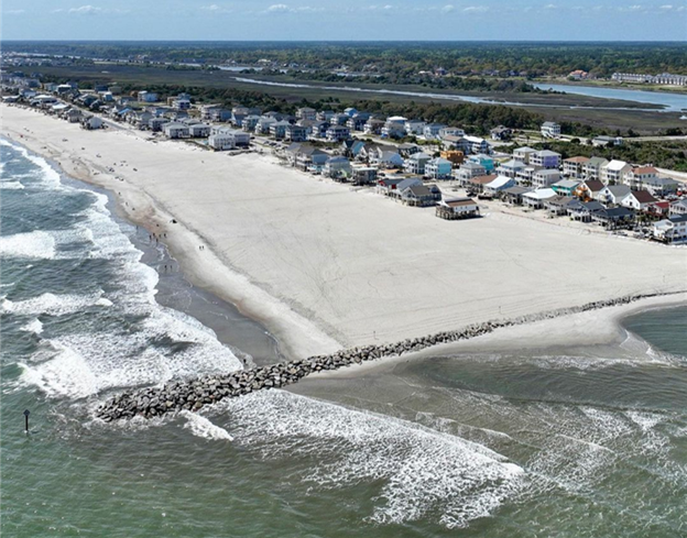 OIB Terminal Groin
Ocean Isle Beach completed construction of a terminal groin on its east end in April 2022 to help protect the beach immediately behind it. However, this structure has contributed to significant erosion at the east end near Shallotte Inlet by interrupting natural longshore drift, prompting ongoing efforts such as sandbag use to prevent ocean encroachment on properties in that area.
2024 OIB SHORELINE AND INLET ANNUAL MONITORING REPORT
On Holden Beach, the recent volume change rates (May 2024 to November 2024) along the oceanfront shoreline indicated erosion at 12 of the 21 monitoring stations. Similarly, the MHW shoreline change rates indicated a shoreline retreat at 15 of the 21 monitoring stations. The long-term post-construction linear shoreline changes along the Holden Beach oceanfront shoreline indicated landward retreat. However, volumetric changes indicated slight accretion (0.2 cy/ft./yr.) within this area over the long-term period. The shoreline threshold analysis results along the Holden Beach oceanfront shoreline show that the post-construction shoreline change threshold was exceeded at only one monitoring station. This is the first time a threshold has been exceeded at Holden Beach since this annual analysis started in 2022. In addition, the analysis of May 2024 aerial imagery-derived wet/dry line revealed an 885 ft. section of Holden Beach’s inlet shoreline that exceeded the inlet shoreline threshold by a maximum distance of 100 feet. The inlet shoreline threshold on Holden Beach was also exceeded in Year-2. This marks two straight years where this threshold was exceeded. The inlet shoreline recession is believed to likely be attributed to a combination of morphological changes within Shallotte Inlet including the position and orientation of the main channel through Shallotte Inlet and the formation of a flood channel on the inlet shoulder of Holden Beach. Regardless, as stated in the Plan, because the shoreline changes in this area exceeded the threshold over the entire 2-year confirmation period, an assessment of the proper responsive measures will be made through coordination with State and Federal regulatory officials.
 Sand is vanishing on east side of Ocean Isles $11M erosion fix
Read more » click here
Town of Ocean Isle Beach provides update on East End erosion
Read more » click here
Erosion at Brunswick beach under review after major road washout
Read more » click here
Ocean Isle seeks to modify permit, nourish beach at east inlet
Read more » click here
Panel takes new look at beach erosion-control structures
Something potentially and significantly consequential is underway now in North Carolina that could alter management of the state’s increasingly battered Atlantic coastline. The state Coastal Resources Commission’s Science Panel is in the process of finalizing an analysis of beach erosion-control structures, a report that is expected to be submitted to the commission in June. Although the 10-member advisory panel’s study is meant to inform policymakers of their options, some fear – or hope – that it’s the first step toward repealing the state’s longstanding ban on hardened shoreline structures. “Alarms are sounding in nearly all of our oceanfront counties,” state Division of Coastal Management Director Tancred Miller said at the commission’s meeting in November at Atlantic Beach, referring to threats from accelerating beach erosion. “Nourishment costs continue to rise and the lifespan of many of these projects is painfully short. Infrastructure is increasingly vulnerable, and some communities are very concerned.” Since September 2025, the Hatteras Island village of Buxton, home of the Cape Hatteras Lighthouse and the massive corner of wild beach known as Cape Point, has seen 19 unoccupied oceanfront homes collapse into the surf. In addition to a beach nourishment project, Dare County this summer is planning to restore the only salvageable groin of a 57-year-old groin field in an attempt to prolong the project’s lifespan. In response to calls from Dare and Hyde counties, among others, to allow more options to address erosion, the division last winter asked the Coastal Resources Commission to review the structures. “We must approach these challenges with open minds, innovation, and balanced pragmatism,” Miller urged. “We must take a critical view of our past and current practices, embrace what continues to succeed, and replace practices that are no longer working.” But even the draft outline that the Science Panel submitted at the commission’s February meeting, titled “Report on The Effects of Hard Structures on Sandy, Open-ocean Coastlines,” revealed the complexity involved in redirecting, blocking, deflecting, buffering, or absorbing the power of an open ocean energized by high winds, with forceful longshore and cross-shore currents feeding beaches with sand here, starving them of sand there. “We’ve broken this into two categories according to how these erosion-management measures function; essentially all erosion-management approaches fall into two categories,” CRC Science Panel Chair Laura Moore told the commission. “One is structures or approaches that trap sand, and the second is structures that that really harden the shoreline.” While the report will provide details about protective barriers and techniques, she said, it is less about offering remedies than providing information about effects of each option. It will also include comparisons to beach-restoration methods such as nourishment and living shorelines. Erosion has been a fact of life along North Carolina’s 320-mile-long ocean shoreline for centuries, but before coastal development and tourism went into overdrive, the Coastal Resources Commission, the 13-member body that sets coastal policy in the state, took steps to preserve beaches. In 1985, after studying the down-shore erosive effects of seawalls, bulkheads, groins, jetties and sandbags, the commission established a policy banning permanent hardened structures on the ocean coast. Sandbags were permitted as temporary structures. Upheld in court in 2000, the ban was codified as law three years later by the North Carolina General Assembly. Then in 2011, a law was passed that permitted a limited number of terminal groins — sand-trapping barriers built near inlets or at the end of an island. Much of the ban, however, remains the law of the land. Environmentalists and countless coastal scientists have credited the limits on hard structures for preserving the state’s coastal wildlife and beautiful natural beaches, which attract millions of tourists every year. But critics blame the ban for limiting the ability to protect shorelines, as well as private and public property and infrastructure. No magic, one-size-fits-all formula exists to address erosion, Moore said, and many factors will need to be weighed. “There are approaches and strategies that can either shift the erosion problem to another adjacent location, or in some cases, we can slow the problem down,” said Moore, who is professor of coastal geomorphology at the University of North Carolina Chapel Hill. “We can create more time to make perhaps bigger adjustments that are likely to be needed going forward.” With seas rising and Atlantic storms intensifying over recent decades as a result of climate change, erosion on the state’s barrier island beaches has been happening faster and more dramatically, especially along the high-energy Outer Banks coastline, where erosion rates at some locations – as severe as an annual average of 14 feet – are among the highest on the East Coast. Dozens of oceanfront houses on eroded beaches, pounded and undermined by surging surf, have fallen into the sea. At the same time, more Outer Banks inlets and waterways are filling with sand, clogging channels that until the recent past had always been navigable. But the entire coast has been experiencing its own degree of changing and increasingly destructive conditions, and the pressure has been building to find ways to prevent or mitigate damages at different locations, each with different conditions. “I would say most of the North Carolina coastline is either barrier or behaves like barrier,” Moore told Coastal Review. “Certainly, subsidence in the north is a factor that’s going to make the relative rate of sea level rise a little higher. But there’s also the shape and the orientation of the shoreline and the wave approach angles and the wave energy and how those drive longshore sediment transport gradients, and how much sand is coming into a stretch of coast versus how much is leaving. Also, a really big factor is how frequently in the past the coast has been nourished.” The final report is to be centered on sand-trapping and shoreline-hardening structures, Moore said. But it will also look at other widely used erosion management tactics, ranging from avoidance with setbacks or relocation, sand trapping with fences or beach plants, and building the beach with sand nourishment and dunes. The two-category design of the document is focused on function of the structures, she said, “because there are hundreds, maybe even thousands, of coastal erosion management approaches out there, and they all essentially fall into two buckets.” What the panel of volunteer scientists cannot do, she added, is analyze each approach. “What we are trying to do is provide a better, clearer explanation of how structures function and what their effects are,” Moore said. Moore emphasized that the science panel’s task is to provide an assessment of structures on the coastline. But she understands the urgency people feel for finding a “solution” rather than a range of options. “And although we’re not providing recommendations, I do want to highlight that we will be discussing tradeoffs, and I think that’s really important, because whether an approach has benefits or negative effects depends on the perspective and goals of the beholder,” she said. “We certainly know that there are efforts afoot to repeal the ban. And again, it’s not our job to say whether that should or should not happen. It’s our job to lay out in a clear way what the tradeoffs are, given how these different approaches to mitigating erosion function.”
Read more » click here
Study of past erosion-control lessons key to ongoing review
As the North Carolina Coastal Resources Commission’s Science Panel studies the effects of permanent beach erosion control structures such as seawalls and jetties, a critical aspect of the analysis will be looking at the lessons learned. The commission banned hardened structures on the ocean shoreline in 1985 because of the down-shore erosive effects on the beach. Still, there are numerous examples of such structures in place along different parts of the coast, with varied degrees of effectiveness. Erosion is not only more severe and longstanding on the Outer Banks, which are more exposed to the power of the open ocean and coastal storms than other parts of the North Carolina coast, it is the most dramatic and unforgiving, especially on Hatteras and Ocracoke islands. But coastal erosion is a statewide issue. To that point, federal beach nourishment projects in North Carolina began in 1965 at Wrightsville Beach and at Carolina Beach, and nourishment at both locations has been done in recent years. When development and tourism took off on the Outer Banks in the 1980s, it didn’t take long before beach cottages began lining ocean shorelines. Still, the forces of erosion had no mercy, and Kitty Hawk began losing beachfront properties. After the commission issued a variance to the hardened structures ban in 2003, permitting sheet-piling along N.C. Highway 12 in the beach community, then-Sen. Marc Basnight strongarmed the state’s ban into legislation. Then in 2011, the North Carolina General Assembly passed a law that permitted four “test” terminal groins and has since expanded the permissible number of groins to seven. To date, four communities submitted permit applications: Figure Eight Island, Ocean Isle Beach, Bald Head Island and Holden Beach. Holden Beach has since withdrawn its application. Long before the ban, numerous attempts were made to shore up the beach oceanward of the 1870 Cape Hatteras Lighthouse in Buxton. By 1930, the nation’s tallest brick lighthouse was a mere 98 feet from the ocean. According to National Park Service records, interlocking steel sheet-pile groins were installed in the 1930s on the beach near the lighthouse and reinforced a few years later. Over the years, dunes were built, grasses were planted, the beach was nourished, revetment and sandbag walls were installed. In 1969, the U.S. Navy installed three reinforced concrete groins to protect its base, which was adjacent to the lighthouse at the time. But the erosion continued. More sandbags were put in place; more beach nourishment was done. The Navy left in the 1980s. While the National Park Service officially gave up its beach nourishment and dune stabilization efforts in 1973, it continued trying in ensuing years to protect the lighthouse from the sea with rip-rap, artificial seagrass, sandbags and a scour-mat apron. Finally, after much study and public debate, with the ocean lapping at its foundation, in 1999 the lighthouse was relocated about a half mile from the beach. Fast-forward a quarter-century and, since September 2025, 19 unoccupied beach houses near that same beach in Buxton have collapsed into the ocean. Escalating beach erosion along the state’s entire coast, but especially in Buxton, has put difficult discussions about lifting the hardened shorelines ban back on the table. The few existing permanent erosion-control structures built over the years on North Carolina beaches have yielded mixed results.
Oregon Inlet
One of the most successful examples of a terminal groin doing what it was intended to do, and with relatively minimal harm, is the 3,125-foot terminal groin and 625-foot revetment built in 1991 to protect the N.C. Highway 12 tie-in at the Herbert C. Bonner Bridge, which has since been replaced and renamed the Marc Basnight Bridge. The $13.4 million groin is substantial — ranging from 110 to 170 feet wide at its base and 25 feet wide at its landward end, and 39 feet wide at its seaward end — and was built to withstand waves as high as 15 feet, according to an analysis done by the state Division of Coastal Management, “North Carolina’s Terminal Groins at Oregon Inlet and Fort Macon, Descriptions and Discussions.” Located on the south side of Oregon Inlet at the north edge of Pea Island National Wildlife Refuge land, the groin placement encouraged sand buildup, or accretion, landward, resulting in a wide expansion of 50 acres of sandy property on the inlet side of the historic state-owned Oregon Inlet Life-Saving Station. The building is vacant but has been weatherized to preserve it for future use. The groin site and surrounding beach have been regularly monitored by state and federal coastal scientists. Studies have shown that the structure has likely increased shoaling of a spit on the Bodie island side and deepening of the channel. Yet, the groin has cause little if any destructive downstream erosion while adequately protecting the highway and bridge infrastructure. But the report warned that within the next 20 years or so, the continued southward migration of the Bodie Island spit could push the inlet’s main navigational channel up against the terminal groin structure itself. “If this were to occur, the result would be severe scour and an increase in the maintenance necessary to preserve the threatened integrity of the structure itself,” according to the document.
Beaufort Inlet/Fort Macon
Since Fort Macon was constructed in 1834, about 25 erosion-control structures adjacent to Beaufort Inlet have been built, including groins, breakwaters, timber cribbing, sand-fencing and seawalls, as well as multiple beach nourishment projects, according to the terminal groin report. The first phase of the terminal groin project began in 1961 and included a 530-foot seawall, a 250-foot revetment and 720-foot long, 6-foot-high terminal groin. Phase II, beginning in 1965, extended the groin 410 feet oceanward, and another groin was built west of the revetment to address extensive sound side erosion, while 93,000 cubic yards of sand was placed on the ocean beach. The third phase, started in 1970, extended the terminal groin another 400 feet, to a total of 1,530 feet long. A 480-foot-long stone groin was built to stabilize the beach fill, and another 100,000 cubic yards of sand was placed on the ocean beach. Total costs for the three-phase project was $1.35 million. Effects of the project include increased wave energy along the Fort Macon State Park and Bogue Banks area and continued increases in wave energy were predicted. A sediment deficit has created erosion on the inlet’s western shoreline. Meanwhile, the sand spit at Fort Macon has migrated into the western bank of the navigation channel, indicating that the terminal groin has become inefficient at trapping sediment. “Without constant beach nourishment, the terminal groin would no longer perform as observed historically and potentially fail altogether,” the report concluded.
Buxton
Dare County is planning a nourishment project in Buxton, as well as restoration of one of the Navy’s three abandoned reinforced sheet-pile groins that had been installed in 1969. According to the recent application to repair the southernmost groin, which is 50% or more intact, that groin had been lengthened in 1982 on the landward side by 300 feet, and armor stone was added two years later. New sheet piles and additional scour protection were added to the structures in 1994. The other two groins in the original groin field are too damaged to qualify under the Coastal Resources Commission’s “50% rule” that permits repairs. Dare County Manager Bobby Outten has said publicly that the county is under no illusions that the project planned for this summer will solve the erosion issue for good. But the hope is that it will serve as a Band-Aid long enough to find a more permanent solution to erosion that is now so severe it is threatening the livelihoods of community residents and the island’s tourism economy, as well as N.C Highway 12. Retired East Carolina University professor and veteran coastal geologist Dr. Stanley Riggs, who has studied the Outer Banks since the 1970s, agreed that the fact that the lighthouse had to be relocated to save it illustrates why Buxton’s erosion is not going to be easy to tame for long, with or without groins. When the first coastal survey from Virginia to Ocracoke was done in 1852, the original 1802 Cape Hatteras Lighthouse, which was destroyed, had been 1,000 feet from the shoreline, Riggs recently told Coastal Review. All told, the shoreline has receded 3,000 feet, or about two-thirds of a mile, at the cape, he said. “And it’s been constant,” Riggs said. “It oscillates a little bit, but the main direction has been constant.” As Riggs explained, offshore just north of the motel area in Buxton, there is an underwater rock structure that is set at an oblique angle relative to the barrier island. Similar “old capes” are also off Avon and Rodanthe, he said. The rocks are under as much as 50 feet of water, and they dictate how the waves refract there. “And so, if you fly over it, and you get the right angle down there, what you see is a series of cusps, and one side of that cusp will be stable, the other side will be highly erosional,” he said. Groins will only make the eroding side erode faster. And when there are permanent or semipermanent structures along the beach, the shore face — the part that is under water — starts to erode and gets steeper and steeper, he said. And the steeper it gets, the more severe the over wash and the more difficult it is to hold the sand in place. That’s a big reason why beach nourishment is having to be done more frequently. Not only does the Outer Banks stick out farther into the Atlantic, but there is also a narrower continental shelf, which allows the bigger waves to come ashore from the open ocean without the wider “speed bump” needed to dissipate the power. There’s no negotiating with the ocean, Riggs said. Considering the combination of coastal dynamics at play in Buxton, efforts to control erosion will continue to fail. “It’s that land-sea-air interface that is really the highest energy place that we’ve got on our planet,” Riggs said. “And there’s some things you can do there. There’s some things you shouldn’t do there, you can’t do there, and it’s a matter of understanding how that system works.”
Ocracoke Island
A persistent erosion hot spot on the north end of the island along N.C. Highway 12, the only road between the Hatteras Ferry Docks and Ocracoke Village, has been patched on and off for decades by increasing numbers of ever larger numbers and size of sandbags. But even the type of large, new, trapezoidal bags permitted at Ocracoke, Pea Island and Mirlo Beach have not held up as expected, according to a presentation provided by Paul Williams of the North Carolina Department of Transportation at the February Coastal Resources Commission meeting. Williams presented details at the meeting of NCDOT’s revised request to increase the base of the sandbags from 20 to 30 feet and the height from 6 feet to 10 feet, to better protect them from being undermined by waves. The newer bags have open ends at the top, which proved to be a problem at Pea Island, Williams told the commission. The Pea Island Refuge at the Visitor Center, he added, faces similar risks now to that seen at Mirlo Beach in Rodanthe in the years before the hotspot was bypassed with completion of the Rodanthe “Jug-Handle” Bridge. “The performance has not been what we anticipated,” he said, describing how they were flooded at the top, which caused the sandbags to deflate. “This product, there may be some modifications that can be made to make them more resilient.” Some of the new bags were also installed along with traditional sandbags at Ocracoke, and they’re still covered, Williams said, but roughly 1 mile of sandbags along N.C. 12 are at risk of being undermined during the next big storm. “So it’s basically to give us more latitude on different products, to try to protect the roadway out there better than traditional sandbags have,” Willams told Coastal Review after the meeting. “We’ve used them for decades out there, and especially Mirlo, they really got tossed around during storms. We were looking to find a more resilient product, and we’re working on evaluating other options out there.” The new sandbags with an opening at the top are quicker to fill, he said. They’ve worked at other areas, but conditions elsewhere are not as fierce. “When you’re on the Outer Banks, you’re under constant pressure during some of these storm events, because we’ll have a storm set up on the coast and grind for days at a time,” Williams said. “And every tide cycle is just steadily pulling sand out of the bags, and we need to have some way to stop that.” Even though many of the traditional sandbags without the troublesome opening are still in place at Ocracoke, Williams said that about half of them, or about 1,000, have been exposed and need to be replaced. Another issue on the island is the limited amount of sand available to cover. Sandbags, which are considered temporary erosion-control structures that are permitted parallel to shore to protect imminently threatened roads or structures, have rules about color and size, but those rules have been notoriously abused with regard to the “temporary” part, with extensions often adding up to decades at a site, making them “hardened structures” in everything but name. Before Nags Head in 2011 started nourishing its eroded beaches in South Nags Head, for instance, even battered and torn sandbags weren’t removed for years, and property owners often successfully sued the state to keep longstanding stacked rows of protective bags in place in front of their oceanfront homes on the eroded beach. As sea levels continue to rise, storms intensify and erosion accelerates, even sandbags as fallbacks in the absence of other impermissible erosion-control structures are becoming less effective, as evidenced by photographs of huge piles of sandbags lined up against undermined houses at North Topsail Beach.
Ocean Isle Beach
Responding to the state legislature’s repeal of the ban on hardened erosion-control structures on the coast, Ocean Isle Beach in 2011 began the planning process to pursue permits to install a terminal groin at Shallotte Inlet to stem erosion that for decades had chewed away at the island’s east end. Five years later, state and federal approval was in hand to build a 750-foot-long terminal groin, but environmental groups in 2017 filed a lawsuit to stop the project. A ruling in March 2021 in the 4th Circuit U.S. Court of Appeals affirmed a lower court’s ruling that the project alternatives were properly considered. By April 2022, the $11 million terminal groin was completed. Today, a diminished beach remains in front of multi-million-dollar homes that were built after the groin was in place. Rows of sandbags block the surf from reaching some of the oceanfront homes, and several lots remain vacant because there is no longer enough property left to meet setback requirements. In November, the Coastal Resources Commission allowed the owners of eroding vacant oceanfront lots to use larger sandbags to protect their properties.
Interest in future terminal groins
The Village of Bald Head Island, the first community to build a terminal groin after the “test groin” law passed, was issued a permit in October 2014 to build the erosion-control structure, which was completed in 2015. North Carolina Department of Environmental Quality monitoring of the project after its completion did not turn up significant issues requiring corrective measures, according to its January 2024 report. “While ongoing post-construction monitoring performed by the permittee has not identified any significant issues that would require corrective or mitigative measures, the Village performed a maintenance beach nourishment event, received nourishment from the U.S. Army Corps of Engineers’ regularly scheduled Wilmington Harbor maintenance project, and is currently seeking permit authorization for a second Village-sponsored maintenance nourishment event,” according to the document. Six other communities have expressed “varying degrees” of interest in building a terminal groin project, including North Topsail Beach and Figure Eight Island, as noted in the report.
Read more » click here
Odds & Ends
North Carolina’s 2026 pollen season has been rough. Here’s why.
Experts say this allergy season has been unusually severe due to climate change, drought, and whipsawing temperatures. And it still has weeks to run. If you think 2026 has been a horrible allergy season so far, you aren’t alone. Officials say a combination of weather events coupled with a changing climate have made this year’s pollen season always a challenge in pine-heavy North Carolina, especially tough for some to handle. And it’s likely to get worse before it gets better, especially if the prolonged dry spell the Tar Heel State has been stuck in for months continues into late spring. “We’ve definitely seen an increase in patients in recent weeks with symptoms that could be cold or the flu,” said Dr. Trenee Little with Wilmington Health. “But after talking to them, it’s allergies.”
Tears and coughs
Pollen is a powder-like substance produced by all flowers, shrubs, grasses and trees that contains the male reproductive cells of plants. It is transported around by insects and the wind. Different plants produce pollen at different times of the year, with trees generally expressing pollen in the late winter and spring, grasses in the late spring and summer, and weeds in the fall. Many people find pollen irritating and a seasonal misery, bringing on watery eyes, sneezing and nasal congestion. Higher pollen counts also can cause asthma and other breathing issues, according to the National Institute of Environmental Health Sciences.
The role of climate change
Researchers have tracked pollen season starting earlier and lasting longer in recent years. “It is something that’s directly related to climate change,” said Greg Paige, director of horticulture at the J.C. Raulston Arboretum at N.C. State University. According to the American Lung Association, a warming climate means the ground is thawing earlier in the spring − or not freezing at all. That allows trees to grow and pollen to be introduced earlier in the year. On average, the pollen season is approximately three weeks longer now in the U.S. than compared to 50 years ago, according to the association. Increased levels of greenhouse gasses also are causing plants and trees to produce about 20% more pollen as compared to 50 years ago. Because of these changes, pollen allergy symptoms are likely to appear earlier in the year and be more severe, according to the medical group.
Dry and getting drier
A natural antidote to heavy pollen is rainfall, which can wash pollen away and out of the air. “But the other factor that’s making this season worse than normal is the statewide drought,” Paige said. According to the National Weather Service, through March 30, 2026, Wilmington had seen 6.45 inches of rain. In a typical year, the Port City would see 11.13 inches, meaning the current rain deficit for the year is nearly 42%. That comes on top of Wilmington ending 2025 with a 14-inch rainfall deficit, 24% below normal precipitation levels for the year. With the situation similar across the state, the N.C. Forest Service on March 28 issued a statewide burning ban until further notice due to the heightened risk of wildfires. Paige said the whipsawing temperatures much of North Carolina has seen in recent weeks − such as Wilmington hitting a high of 90 degrees on March 23, only to see the mercury dip into the 50s a day later, according to the weather service − also has likely added to the pollen problem. “That causes the plants to think it’s time to get going and do their thing,” he said.
How are things looking in N.C. these days?
That lack of rain means more pollen, especially pine pollen, has been floating around and coating anything and everything outside in recent weeks. The N.C. Division of Air Quality runs one official pollen recording station, in Raleigh. While readings for March 30-31, 2026, showed “low” levels of grass and weed pollen in the air, pollen from trees were “high” − the second highest rating behind “very high.” Recent daily reports show tree pollen counts had been “high” or “very high” every day since March 12, 2026. Pine trees release large amounts of pollen into the air, especially during warm, dry and breezy conditions, making the yellowish-greenish dust one of the most visible signs of early spring.
Will things get better?
Yes, and no. Pollen counts typically peak in early April, driven primarily by tree pollen. By mid- to late-April, tree pollen levels generally begin to decline. But any relief could be short-lived as grass and weed pollen start to increase heading into late spring and early summer. A few months of respite will then occur for those with allergies before ragweed season starts in earnest in the fall. Wilmington Health’s Little said the ideal thing to do on heavy pollen days is to try and limit your time outside. But if you must exit the house, try to limit your exposure and change clothes when you get home if you’ve been outside for an extended period of time. And if you need some relief, there are several over-the-counter options − including nasal sprays that work quite well, Little added. But in serious cases, folks might need to see their doctor to get something a bit stronger. “This, too, will eventually pass,” the arboretum’s Paige said of the 2026 Great Pollination. “But it still could be a tough few weeks.”
Read more » click here
This and That

Alerts
Brunswick County uses ReadyBrunswick as part of the County’s effort to continuously improve communications during emergency situations within our area. Powered by Everbridge, the ReadyBrunswick notification system sends emergency notifications in a variety of communication methods such as:
-
-
- Landline (Voice)
- VoIP (Voice over Internet Protocol)
- Mobile (Voice)
- Mobile SMS (Text Messaging)
-
In the case of an emergency, you may choose to receive notifications via one or all of these communication methods. It’s recommended that you register several media options to receive messages in the event a particular communication device is unavailable.
For more information » click here
Brunswick County Emergency Communications Notification System
Get notified about emergencies and other important community news by signing up for our ReadyBrunswick Emergency Notification System. This system enables us to provide you with critical information quickly in a variety of situations, such as severe weather, unexpected road closures, missing persons, evacuations of buildings or neighborhoods, and more. You will receive time-sensitive messages wherever you specify, such as your home, mobile or business phones, email address, text messages and more. You pick where, you pick how.
SIGN UP HERE to choose the type of alerts you want to receive
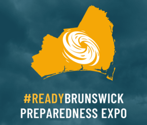 Brunswick County’s 2026 ReadyBrunswick Preparedness Expo is Tuesday, May 5
Community members and visitors are invited to join Brunswick County for the annual ReadyBrunswick Preparedness Expo. The event will take place from 10 a.m. to 2 p.m., Tuesday, May 5, on the Lisa M. Thompson Walking Trail at the Brunswick County Government Center. Parking is available in front of the David R. Sandifer Administration Building, located at 30 Government Center Drive in Bolivia. This family-friendly event is free to attend and will feature over 50 local businesses and organizations that are ready to show you and your loved ones how to achieve a healthy and resilient lifestyle, guide you in developing an emergency plan, teach you about organizations that can assist with recovery needs, and more. There will be free Sunset Slush Classic Italian Ice, popcorn, a vast display of rescue vehicles, a free raffle contest, handouts, interactive demonstrations, health screenings and other activities. Free demonstrations include nutrition planning, cross-fit and yoga. Food can be purchased from the various food trucks that will be on-site. For any questions or vendor opportunities, contact our Emergency Management team at (910) 253-1923 or (910) 253-1923 or via email at mikayla.borrero@brunswickcountync.gov. Find preparedness information on the county’s website anytime at BrunswickCountyNC.gov/emergency. Learn more about the ReadyBrunswick Emergency Notification System and sign up at ReadyBrunswickCountyNC.gov.
Read more » click here
Turtle Watch Program –

Turtle Watch Program – 2026
Members of the patrol started riding the beach every morning on May 1 and will do so through October looking for signs of turtle nests.
For more information » click here.
..
.
Turtle Talks
The Holden Beach Turtle Watch Program conducts weekly educational programs on selected Wednesday evenings in June, July and August. Please check our Events Calendar for details on dates, times and locations. Seating is limited.
Children’s Turtle Time
Special programs for younger turtle enthusiasts are held at 4 p.m. on Wednesday afternoons in June, July and August on select dates.
Both programs are free of charge and will be held at the Holden Beach Chapel.
How you can protect sea turtles at NC beaches during nesting season
People aren’t the only folks flocking to North Carolina’s beaches as the weather warms up. In the coming weeks, beachgoers could find themselves sharing the sand with mamma sea turtles and shorebirds looking for a spot to start a new family. Already, skimmers, oystercatchers and other birds are vying for space on the sandy spits at the tips of barrier islands like Wrightsville Beach, and North Carolina has already seen one false crawl by a sea turtle even though sea turtle nesting season doesn’t generally start until May 1, according to the N.C. Wildlife Resources Commission. But sharing the beach can be a challenge, with the deck largely stacked against coastal wildlife as the lure of sand and the ocean keeps attracting more and more people to the N.C. coast − never mind the other challenges the animals face in the wild off the beach. Still, officials say following a few simple rules can give the critters a flipper and wing up during their beach visit. “Seeing a sea turtle on the beach is a wonderful, rare experience,” said Terry Meyer, deputy and conservation director at the Karen Beasley Rescue and Rehabilitation Center in Surf City. “But just keep a respectful distance while enjoying it.”
One in 1,000
Sea turtle nesting season in North Carolina occurs from May through September. Female sea turtles emerge from the ocean at night, and using their flippers, dig an 18-inch-deep hole that will serve as the nest where she will deposit 80 to 120 eggs. After laying the eggs, she covers the nest and returns to sea. After about a 60-day incubation period, the hatchlings emerge and make their way to the ocean. Only about one in 1,000 hatchlings will live to reproduce. In 2025 North Carolina recorded 1,088 nests, with the first one recorded on Topsail Island on May 8, 2025. The first nest to emerge was a Kemp’s Ridley nest on Ocean Isle Beach on July 10, 2025. The vast majority of North Carolina nests were laid by loggerheads. Green sea turtle nest numbers are slowly increasing in the state, with Tar Heel beaches seeing 58 last year. There also were 10 Kemp’s Ridley nests.
Range of threats
Both in the water and on land, sea turtles face a range of threats. In the ocean, dangers range from entanglement in fishing gear to boat strikes to ingesting plastics and other trash. But that’s if the hatchlings even make it off the beach to have a life at sea. “Our No. 1 greatest threat by far is artificial lighting,” Meyer said. She said it’s the biggest concern because the lights can not only disorientate the nesting female as she comes ashore, but also hatchlings as they move toward the brightest light they see when they come out of their nest. In a perfect world, that’s the moon or the stars as they make their way toward the ocean. And it isn’t just exterior lighting that is a problem. Meyer said a recent study found 57% of the light pollution along the Topsail Island beachfront was from interior lights − a major concern since many oceanfront homes don’t have shades or curtains on their ocean-facing windows. Factor in a rotating mix of residents as vacationers cycle on and off the island almost weekly and it’s a constant battle for the turtle volunteers and others to get the message about lighting out there. “We just can’t stay ahead of the light situation,” Meyer said, noting volunteers hand out door hangers warning about the danger of keeping lights on at night and promote the use of turtle-friendly ambient light bulbs for exterior uses instead of traditional bulbs. “It’s definitely a challenge.” Predators like foxes and raccoons along with overanxious tourists eager to see and get selfies with a giant marine reptile that predates the dinosaurs are other challenges nesting sea turtles and their hatchlings can face. Climate change also is a growing concern. On the beach, the warming weather is increasing sand temperatures, which helps determine the sex of hatchlings as the buried eggs incubate. If the beach is warmer than 89 degrees, most of the hatchlings will be female; if it’s cooler more will be male. For a long time, researchers have believed that the cooler beaches in the Carolinas produced males to mate with the female-heavy hatchlings produced by the warmer beaches in Florida and along the Gulf Coast. But what will happen if all the country’s beaches get so warm that the vast majority of hatchlings are female? A warming climate, which scientists are predicting for North Carolina in the coming years, also could impact when sea turtles nest, prompting turtles to lumber ashore earlier than the traditional May start date.
‘Fill in those holes’
The Topsail Turtle Project, run by the sea turtle hospital, monitors the beaches in Topsail Beach, Surf City and North Topsail Beach. With volunteer groups in other beach towns along with federal and state agencies, officials monitor all 330 miles of ocean-facing sandy beaches in N.C. for sea turtle nests, stranded animals and even signs of false crawls. “We want them all counted, all documented,” Meyer said. “We want to know how many turtles we have.” If an injured or stressed sea turtle is found, it often ends up at the sea turtle hospital. As of April 21, the turtle hospital was treating 45 patients − most cold-stun victims from this winter that were slowly being nursed back to health. Kathy Zagzebski, the hospital’s executive director, said during the busy fall and winter season the facility sometimes deals with more than 100 turtles at a time, many cold-stunned animals brought down from New England for treatment. Recovery times can often take several months per turtle. As the weather warms up, the hospital sees fewer turtles being brought in suffering from hypothermia or other temperature-related issues. But the animals that are brought in are often those that have been accidently hooked by a fishermen or hit by a boat. “We usually see fewer turtles, but those that we do see probably require more treatment,” Kathy said. Like Meyer, Zagzebski said just taking a few steps and being considerate can help people and sea turtles better share the state’s coastal environment. “And fill in those holes,” she said, noting that holes dug on the beach can deter mother sea turtles from nesting and prevent hatchlings from reaching the ocean after they emerge from the nest.
Read more » click here
The N.C. Sea Turtle Project works with 20 different volunteer groups. Contact information for each is available at nc-wild.org/seaturtles/contacts, or call the statewide sea turtle hotline at 252-241-7367.
Fauna & Flora –

NC State Native Plant Resources » click here
NC Native Plants for Pollinators » click here
NC Sea Grant Coastal Landscapes » click here
New Hanover County Arboretum Native Plant Garden » click here
Audubon Native Plant Database » click here
North Carolina Extension Gardener Plant Toolbox » click here
Fauna & Flora » click here
Holden Beach recommended plant list – deer resistant & salt tolerant
Factoid That May Interest Only Me
As Wilmington grows, here’s how to coexist with your wild neighbors
People aren’t the only things attracted to coastal North Carolina. But learning to live together with the region’s wild animals can require some give-and-take.
Californians might be used to living in cougar country, but what about sharing a pond with alligators? And folks from New England know they need to share the road with moose, but what about sharing the water with manatees? As the Wilmington area continues to grow, attract new residents, and push development out into formerly wild areas, traffic on South College Road isn’t the only thing that’s increasing. So are human-animal interactions, especially during spring and early summer as animals stir from their wintry slumber and start moving around looking for breeding partners. With many new Cape Fear residents from other parts of the country, which can leave officials facing a challenging situation of educating new Wilmingtonians about what to do when you come across a critter you might not be sure how to deal with. “I was ready for the hurricanes. I studied up on what to do when one comes this way,” said Jenny Miller, who recently moved to Leland from Ohio. “But I wasn’t expecting to run into alligators on my walks.”
Rapid growth
If you’ve been stuck in traffic on U.S. 17 in Leland or Market Street in Wilmington, you know it’s been on overdrive for several years now. Between July 1, 2024, and July 1, 2025, the Wilmington-metro area was the seventh fastest-growing metro in the U.S. by percent growth. In just that year, the area gained 12,398 new residents, going from a population of 480,374 to 492,772. This constitutes a growth percentage of about 2.6%. According to the U.S. Census Bureau, only six other metros grew at a faster rate than the Cape Fear region − and the influx of new residents shows no signs of slowing down. The population of New Hanover, Brunswick and Pender counties is expected to be more than 743,000 by 2050. And with more people in more areas come more sightings and experiences with the local wildlife.
 Bears at the coast
Yes, and lots of them. Today, more than 20,000 bears are estimated to roam North Carolina, and more than half are in the eastern part of the state. As the weather warms and bears that do hibernate start stirring, sightings and interactions with the region’s growing population is inevitable. The growing human and bear populations in the state has prompted the N.C. Wildlife Resources Commission to promote a program called BearWise, which offers recommendations for everyone to coexist with their hairy neighbors.
 Cows of the ocean
If you think manatees, you probably think Florida. But the marine mammals, also known as sea cows, have always migrated through North Carolina’s coastal waters. Sightings and interactions, though, have been on the rise as the number of people living and playing at the N.C. coast increase and the number of manatees continues to grow thanks to educational outreach and protective measures where the animals are known to congregate − especially in Florida. In a recent high-profile case in North Carolina, a manatee had to be rescued from the Tar River near Greenville in November 2024 after getting stranded up the river from Pamlico Sound as temperatures plummeted. Still, researchers say the lumbering and slow-swimming mammals aren’t out of the proverbial woods yet. The docile animals swim at or near the surface, making them very susceptible to boat strikes. Loss of habitat along waterways to development and declining water quality, especially algal blooms fueled by fertilizer runoff, also have depleted manatee numbers. While a treat to see a manatee, scientists say the best thing to do if you see a manatee is nothing. Interacting with a manatee, which has strict federal and state protections, also can come with a hefty fine and other legal actions. Residents also are asked to report any manatee sightings to authorities, like the UNCW Marine Mammal Stranding Program, to help researchers track the population and range of the animals in North Carolina.
 Toothy and scaly – but not scary
April means several things in Southeastern North Carolina, including tax time, the N.C. Azalea Festival, the scourge of pollen − and alligator mating season. While most of those can’t be avoided, having a stress-free gator spring is generally easy to do. “If you see an alligator, don’t feed it, don’t approach it, and don’t provoke it,” said Chris Kent, a biologist with the N.C. Wildlife Resources Commission whose district includes much of coastal N.C., told the StarNews in 2025. “If you leave them alone, almost all the time they’ll leave you alone, too. People’s attraction to the water, whether natural waterways or manmade canals and lakes, has increased interactions with gators since they also are attracted to water features. Still, the presence of an alligator doesn’t mean it needs to go, officials said. Relocation rarely works since another gator will quickly takes its place. Instead, they promote education and proactive steps to help people and alligators coexist. Those include fencing around ponds or creeks − although that can run afoul of HOA rules − and moves to stop feeding ducks and turtles, which gators eat.
 Venomous, but wants to be left alone
It might come as a surprise to locals and new arrivals alike that Southeastern North Carolina is home to a host of reptiles and bugs that can sting, bite or basically ruin your day. But as with almost every other wild animal, there are some pretty simple steps you can take to keep adults, kids and pets safe. While the Wilmington area is home to more than 100 species of spiders, according to the N.C. Biodiversity Project, it’s two particular species of arachnids − which aren’t insects − that can cause the hair on the back of most people’s necks to stand up. They are the black widow and the brown recluse, both of which are venomous. Both spiders prefer to live in dark, generally dry places that can include garages, sheds, woodpiles and rocky areas. Avoid those areas, or be careful when disturbing them, and you should be safe from an accidental bite, scientists say. Ditto for the region’s slithery residents. North Carolina is home to nearly 40 different species of snakes, with six of those venomous. With its preponderance of longleaf pine forests and wetlands, the Cape Fear region has perfect habitat for some of those venomous ones, including copperheads, cottonmouths, the highly venomous Eastern coral snake and a couple species of rattlers. But while they might try to appear aggressive when threatened, cornered or just surprised, snakes really don’t want to mess with people. “In almost all cases, a snake will put on a good defensive display and hold its ground if it feels threatened,” Dr. Bryan Stuart, curator of herpetology at the N.C. Museum of Natural Sciences, told the StarNews last year. “But if you let them be, they’ll do the same for you.”
Read more » click here
Why animals like Alligators and Bears are showing up more than usual
Spring is here, and that means wildlife–like Alligators and Bears– are becoming more active. Wildlife Officials say now is the time to take simple steps around your home to prevent these unwanted wildlife encounters. Imagine stepping outside on a bright, sunny morning only to find an alligator waiting on your porch. For some Brunswick County residents, that scenario has become increasingly common in recent days. Wildlife officials say the spike in sightings is tied to seasonal behavior and environmental conditions, not unusual aggression. “Part of my job is to help people coexist with alligators, or to address nuisance situations,” said wildlife biologist John Henry Harrelson. Over the past week, a number of residents have reported alligators appearing in yards, swimming in lakes and even sheltering under vehicles. The sightings, while startling, are expected this time of year. Harrelson said alligators are on the move, looking for a mate, just like one spotted in a pond in Southport near a neighborhood. “To me, that told me that alligator was wanting to leave the pond anyway, which makes sense, because it’s getting ready to be mating season,” Harrelson said. “We’re kind of on the cusp of it right now, and so a lot of alligators are moving around.” In addition to seasonal movement, rapid development in Brunswick County is contributing to increased encounters between humans and wildlife. As new neighborhoods expand, natural habitats shrink, forcing animals to relocate. “We are definitely encroaching on their habitat and encroaching on populations,” Harrelson said. “The more people we have coming to these areas, the more we’re going to have those encounters if people are not being proactive in how we approach coexisting with this wildlife.” Drought conditions are also playing a role, pushing alligators to seek out water sources such as retention ponds in residential areas. Another reason why alligators are showing up more in public, is the drought. They are moving into retention ponds in search of water, but they are not the only ones. “Bears are waking up from their wintertime slumber and coming out and being more visible,” Harrelson said. “This time of year, they’re really hitting food sources, trying to recover. Females are trying to produce milk for their young, and males are ramping up for breeding season.” Safety officials say when it comes to alligator encounters, always assume they may be present. Never feed, harass, or attempt to capture them. Avoid disposing of food or fish scraps in the water. Pet owners should stay alert and keep animals close, and everyone should use extra caution around ponds, lakes, and other bodies of water.
Read more » click here
With 2 alligator encounters in Southport this week, here’s what to know
It’s been a busy week for the Southport Police Department and Animal Protective Services. Twice, they’ve had to wrangle alligators that have gotten a little too close for comfort. On Wednesday, April 15, they were called to a home in Southport around 3:30 p.m. in reference to a large alligator in the caller’s driveway, according to a post on the police department’s Facebook page. By the time officers arrived, the gator had made its way to the porch of a nearby home. With the help of N.C. Wildlife officers, the 12-foot alligator was safely captured and was relocated, the department reported. The next day, Thursday, April 16, police officers and Animal Protective Services helped capture a large alligator that had been hit by a car in the drive-thru of Truist Bank on Howe Street. When N.C. Wildlife arrived, they determined the gator needed to be relocated. It was loaded and transported away to a safer location, according to the Southport Police Department. “As the weather starts to get warmer, the potential for alligator interactions increases,” the police department said, urging residents to stay alert and take precautions.
Tips for dealing with alligators
Here are some tips from the N.C. Wildlife Resources Commission (WRC) on coexisting with alligators:
-
- Don’t feed them. The No. 1 reason bad human-gator interactions occur is because people intentionally feed the reptiles, allowing them to associate people with food and lose their fear of being near humans.
- Secure pets near water bodies where alligators have been seen. While fish, snakes, turtles and waterfowl are their favored foods, they have been known to pick off small mammals like muskrats − and dogs.
- Like many animals, alligators are most active between dusk and dawn, which is also when they primarily feed. Practice extra caution at night around bodies of water where gators are known to frequent.
- Never approach an alligator, no matter its size. View them from a safe distance, especially adult animals.
Facts about alligators in North Carolina
Here are some factoids about North Carolina’s top natural predator:
-
- North Carolina represents the northern most limit of the alligator’s range. Population density increases as you move south from Virginia to South Carolina, roughly following the warming temperatures.
- There are believed to be a few thousand alligators in the Tar Heel state, running all along the N.C. coast and extending into the coastal plain roughly as far inland as Interstate 95 in southern parts of the state. The WRC is in the midst of conducting a more specific population survey.
- North Carolina toyed with having a limited gator hunting season several years ago, allowing municipalities with nuisance gators or too many animals an option to control their numbers. But few towns took up the offer, fearing the public relations fallout for hunting an animal that has federal and state protections, and the idea has since been shelved.
- While alligators in states farther south, like Louisiana and Florida, are active and grow throughout most of the year, North Carolina gators go into near-hibernation during the colder winter months. That means Tar Heel gators take longer to grow large and mature than their southern neighbors.
- In North Carolina, male alligators − who can be very territorial − can reach 13 feet and weigh up to 500 pounds or more. Females generally grow to less than 9 feet and weigh up to 200 pounds.
- Research shows that both genders tend to be capable of reproduction at around 6 feet in length, with males in North Carolina believed to take 14-16 years to reach sexual maturity, while females require 18-19 years.
- Alligators can live more than four decades in the wild. Nests can include up to 45 eggs, with females protecting their young for up to two years.
- Orton Pond, a 500-acre lake in Brunswick County roughly halfway between Leland and Southport, is believed to have the highest density of alligators in North Carolina.
- If you know of someone intentionally feeding or harassing an alligator, call WRC’s enforcement hotline at 800-662-7137. For information about best ways to make your pond or local waterway less inviting to gators, call 866-318-2401.
Read more » click here
Storm Events
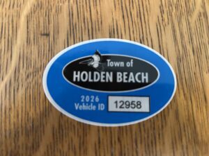 Hurricane Vehicle Decals
Property owners were provided with four (4) decals that were included in this month’s water bill. It is important that you place your decals in your vehicle or in a safe place. A $10 fee will be assessed to anyone who needs to obtain either additional or replacement decals. Decals will not be issued in the 24-hour period before an anticipated order of evacuation.
The decals are your passes to get back onto the island to check your property in the event that an emergency would necessitate restricting access to the island. Decals must be displayed in the driver side lower left-hand corner of the windshield, where they are not obstructed by any other items. Officials must be able to clearly read the decal from outside the vehicle.
Property owners without a valid decal will not be allowed on the island during restricted access. No other method of identification is accepted in an emergency situation. Click here to visit the Town website to find out more information regarding decals and emergency situations.
NC General Statute 166A-19.22
Power of municipalities and counties to enact ordinances to deal with states of emergency.
Synopsis – The governing body may impose by declaration or enacted ordinance, prohibitions, and restrictions during a state of emergency. This includes the prohibition and restriction of movements of people in public places, including imposing a curfew; directing or compelling the voluntary or mandatory evacuation of all or part of the population, controlling ingress and egress of an emergency area, and providing for the closure of streets, roads, highways, bridges, public vehicular areas. All prohibitions and restrictions imposed by declaration or ordinance shall take effect immediately upon publication of the declaration unless the declaration sets a later time. The prohibitions and restrictions shall expire when they are terminated by the official or entity that imposed them, or when the state of emergency terminates.
Violation – Any person who violates any provisions of an ordinance or a declaration enacted or declared pursuant to this section shall be guilty of a Class 2 misdemeanor.
Hot Button Issues
Subjects that are important to people and about which they have strong opinions

Climate
For more information » click here.
There’s something happening here
What it is ain’t exactly clear
The Balance That Keeps Climate Stable Is Out of Whack, U.N. Report Finds
The continued burning of fossil fuels is locking heat in Earth’s atmosphere, oceans and land — instead of allowing it to reflect back into space, a new report finds.
The Earth is out of balance. That’s the message from a United Nations report released late Sunday that looked at how much energy from the sun is absorbed by the Earth or reflected back into space. Researchers found the gap between the two is the biggest since measurements began in 1960, meaning more of the sun’s heat energy is now staying on Earth. And that energy imbalance is heating up the oceans, atmosphere, and frozen regions of the world, according to the World Meteorological Organization’s State of the Global Climate report. Ashkay Deoras, a research scientist at Britain’s National Center for Atmospheric Science at the University of Reading, likened the planet to a heated room with the windows closed. “If you open the window, naturally, you will allow the hot air to escape,” said Dr. Deoras, who was not associated with the report. “But now what is happening is that, because of all these greenhouse gases, they are just trapping more and more heat. The planet is just not getting a chance to cool down.” In previous reports, the U.N.-based meteorological organization documented changes in each element of the Earth’s system, such as surface temperatures, ocean heat, melting glaciers and sea level rise. This year, the authors, who include climate scientists and meteorologists, examined shifts on a wider scale. “The energy imbalance gives you the full picture,” Karina Von Schuckmann, an author of the report and senior adviser at Mercator Ocean International, a French scientific oceanographic organization, said at a news briefing. Under a stable climate, about the same amount of energy comes in from the sun as is reflected back. Now, however, emissions of heat-trapping greenhouse gases — carbon dioxide, methane and nitrous oxide — have surged to their highest level in at least 800,000 years and have upset this equilibrium, the researchers found. The past 11 years have been the hottest since record-keeping began. Last year was either the second- or third-hottest on record, depending on which record is used, with global average temperatures 1.43 degrees Celsius (2.5 degrees Fahrenheit) higher than preindustrial levels. The year 2024 was the hottest year, at 1.55 degrees Celsius above the preindustrial average. The world’s oceans continue to warm as they absorb carbon dioxide from the atmosphere. The extent of sea ice in the Arctic region is at or near a record low, while Antarctic sea ice extent was the third lowest on record, according to the report. Describing the energy imbalance allows scientists to assess the rate of global warming because it encompasses all the components of the climate system. “Sometimes independent graphs are not explaining the full narrative,” said Ko Barrett, deputy secretary-general of the W.M.O. and a former U.S. climate official during the Biden administration. The surplus energy that the Earth retains gets moved around from ocean to atmosphere to land. The increase in heat within the climate system raises the likelihood and intensity of extreme weather events such as powerful storms, heat waves, droughts and extreme rainfall. About 91 percent of the Earth’s surplus heat energy is stored in the oceans; 5 percent is stored in land, 3 percent in ice sheets, and 1 percent is stored in the atmosphere near the Earth’s surface — where it affects the temperatures that humans feel, the report said. The amount of heat stored in the oceans reached a record high in 2025. The rate of ocean warming more than doubled from the period between 1960 and 2005 to the period between 2005 and 2025, the report stated. One worrying result is that scientists are detecting more heat deeper in the ocean, rather than just at the surface, according to Dr. Von Schuckmann. Below 2,000 meters, oceans store and hold heat longer than at the surface layer, which releases it to the atmosphere. That means that the effects of climate change will continue for a long time, she said. “The more we have heat kept away from communication with the atmosphere,” Dr. Von Schuckmann said, “the more we are moving to time scales of committed climate change of 400 to 1,000 years.”
Read more » click here

Flood Insurance Program
For more information » click here

National Flood Insurance Program: Reauthorization
Congress must periodically renew the NFIP’s statutory authority to operate. On February 3, 2026, the president signed legislation passed by Congress that extends the National Flood Insurance Program’s (NFIP’s) authorization to September 30, 2026.
Congress must now reauthorize the NFIP
by no later than 11:59 pm on September 30, 2026.

GenX
For more information » click here

Homeowners Insurance
For more information » click here
NC Rate Bureau proposes nearly 70% increase on dwelling insurance policies
Living along the coast is already expensive, and now the cost could be going even higher if it’s not your primary residence. The North Carolina Rate Bureau (NCRB) is proposing an average rate increase of 68.3% for dwelling insurance policies, a move that would affect vacation homes, rental properties, and other non-primary residences across the state. North Carolina Insurance Commissioner Mike Causey said he opposed the proposal from the start. “In this case, in my view, this is excessive,” Causey said. The increase would be implemented over two years. In the first year, consumers would see a 28.5% increase, then a 30.9% increase in the second year. A $400,000 dwelling policy averages $2,071 per year. This increase would make it jump to roughly $3,479 per year. If the proposed increase were to take effect, the first hike would take effect on July 1, 2026, with the second on July 1, 2027. Causey says the biggest reason for the jump is inflation, rising claim costs, and insurance fraud cases going up. To clarify, there is a difference between dwelling insurance and homeowners’ insurance. Dwelling insurance usually covers homes that are not your primary residence.
Such policies are often purchased for the following types of properties:
-
-
- Vacation homes
- Vacant homes
- Seasonal homes
- Secondary homes
- Rental properties
- Older homes
-
When Causey was initially presented with the proposal, he says he said no. “So, what happens when you say no, you’re required to go to court,” said Causey. Because the rate bureau and Department of Insurance are separate and the power lies with the state agency, the two often reach settlements that produce significantly less extreme policy increases. A hearing is still scheduled for May 4 to work toward a resolution. However, the Department of Insurance and the NCRB can negotiate a settlement beforehand. “We’re in talks right now,” said Causey. “I can’t talk about the negotiations, but we’re hopefully to come up with something that would be favorable.” The last NCRB dwelling rate increase filing was in July 2023, requesting an average statewide 50.6% increase. A settlement was negotiated, resulting in an average 8% increase. “When you can cut more than two-thirds of what they were trying to raise, that puts money back in your pocket, and consumers can live with something reasonable,” said Causey.
In the wake of the proposed rate increase, the North Carolina Rate Bureau released the statement below:
“By its nature, insurance tries to manage risk in a wide range of situations, so there are many different types of property insurance policies. Dwelling policies generally cover rental properties owned by landlords as well as vacation homes, as opposed to primary homes that the owner lives in.
Primary homes are covered by homeowners’ policies and will not be affected by this filing. The NC Rate Bureau reviewed data on tens of thousands of actual insurance claims from 2019 through 2023 to determine the premiums needed to cover risks and build this request. We’ve asked for a substantial increase in the dwelling rate because claim costs have increased substantially. Climate change is here, and so are the financial costs from it. The 27 separate billion-dollar disasters that hit the United States in 2024 would have been an all-time record, had it not been for the 28 billion-dollar disasters that hit in 2023. Adding to these costs: Inflation in the construction industry has far outpaced overall inflation in recent years, and some of the fastest-growing areas in North Carolina are coastal areas where storm damage is more common. Simply put, severe storm damage is becoming more common, it’s impacting more homes, and it’s more expensive to rebuild afterwards. The Rate Bureau tries to strike a balance between affordable rates, rates that cover the risks to properties, and rates that encourage a large number of insurance carriers to compete for business in North Carolina. Finally, whatever rates the Department of Insurance approves, customers should not necessarily expect their premiums to increase by that amount. Rates vary by geography, by carrier, and based on how each insurance carrier assesses an individual property’s risk. The rate-setting process we’re engaged in with the Department of Insurance caps premiums that property insurance carriers charge, but the actual premiums are set on a case-by-case basis.”
Read more » click here

Hurricane Season
For more information » click here
Hurricane season runs from June 1 through November 30

Inlet Hazard Areas
For more information » click here
Commission to consider updating inlet hazard areas
The North Carolina Coastal Resources Commission is to meet next week to consider proposed language amendments for inlet hazard areas. The meeting for the commission, which establishes policies for the N.C. Coastal Management Program and adopts rules for both the Coastal Area Management Act and the N.C. Dredge and Fill Act, will begin with a field trip to Ocean Isle Beach’s terminal groin at 3 p.m. on April 15. The full commission meeting is scheduled for 9 a.m. on April 16 at 111 Causeway Drive, Ocean Isle Beach. An in-person public comment period is scheduled for 9:30 a.m. that day. The public may sign up to speak upon arrival at the meeting. Members of the public may attend in-person or join the meeting Thursday through the North Carolina Department of Environmental Quality’s YouTube channel. The commission establishes areas of environmental concern, which are authorized under CAMA, and are the bases of the permitting program for regulating coastal development. There are three types of ocean hazard AECs: ocean erodible, inlet hazard, and unvegetated beach. The ocean erodible area is “the area where there exists a substantial possibility of excessive erosion and significant shoreline fluctuation,” and the inlet hazard area is defined as “locations that ‘are especially vulnerable to erosion, flooding and other adverse effects of sand, wind, and water because of their proximity to dynamic ocean inlets,” according to the division, which carries out the rules and regulations for the commission. During the meeting, the commission will consider ocean erodible area and inlet hazard area erosion rates and setback factors. The division has since 1979 used the same long-term erosion data to determine construction setbacks in inlet and ocean hazard areas, and to establish the landward boundaries of ocean erodible areas of environmental concern. The commission’s setback rules are used to site oceanfront development based on the size of the structure according to the graduated setback provisions. In areas where there is a high rate of erosion, buildings must be located farther from the shoreline than in areas where there is less erosion. The size of the structure determines how far back a house must be located away from the shoreline. Because of limited data and resources, erosion rate setback factors within inlet hazard areas have traditionally been based on the rates of adjacent ocean erodible areas. “Given the rapid changes that can occur at inlets, this method has often resulted in setback factors that underestimate the true erosion dynamics of these areas,” division documents state. During the commission’s August 2025 meeting, Dr. Laura Moore, the chairperson of the commission’s Science Panel on Coastal Hazards, presented the panel’s recommendations on updated boundaries for inlet hazard areas and ocean erodible areas, and their corresponding erosion rate setback factors. A subcommittee was appointed at the time to evaluate the possible changes and presented its recommendation during the February meeting. Updating ocean hazard area boundaries for inlet hazard areas and ocean erodible areas, along with the associated erosion rate setback factors, requires rule amendments to reference the updated report and maps, documents continue. Because inlet hazard area boundaries have remained static and adjacent ocean erodible area erosion rates were applied within the inlet hazard areas, the primary amendment has been to the rule “to simply reference the updated oceanfront erosion rate report. However, this update includes revised IHA boundaries and inlet-specific erosion rates within IHAs, necessitating additional rule amendments to reference the applicable reports, maps, and use standards,” documents explain. Division staff noted that the 2025 study is consistent with previous update studies, in that inlet hazard area boundaries at undeveloped inlets were not analyzed. The commission at this month’s meeting is to consider approving rule amendments that reflect the subcommittee’s findings and recommendations and supported by the Coastal Resources Advisory Council, updated inlet hazard boundaries, and updated ocean erodible areas and inlet hazard areas erosion rate setbacks, to include ocean erodible areas landward boundaries. Division staff are to recommend removing the inlet hazard area designations from Little River Inlet, New River and Brown’s Inlets at Marine Corps Base Camp Lejeune, Bogue Inlet at Hammocks Beach State Park, Barden Inlet, Ocracoke Inlet and Hatteras Inlet. “It is important to note that while inlet hazards are present at these sites, these areas are not being developed,” staff said. In addition, division staff are to present updates on septic systems within the ocean hazard areas of environmental concern, consider draft rule amendments for human-made ditches requested by a petition for rulemaking, and a permit for temporary weather monitoring structures on the beach in the ocean hazard area of environmental concern. The full meeting agenda and briefing materials are on the commission’s website.
Read more » click here
Commission moves forward with inlet hazard area updates
North Carolina’s Coastal Resources Commission is moving through the steps to update rules for building along high-hazard coastlines that are particularly vulnerable to erosion and flooding. When the commission met April 16 in Ocean Isle Beach’s town hall, members voted unanimously to advance the rulemaking process to draft language amendments for ocean erodible areas and inlet hazard areas. Proposed changes include using the most recent data for erosion rates and maps for the two zones, which are classified as areas of environmental concern. If approved, this will be the first time new inlet hazard boundaries have been updated since they were initiated in the late 1970s. The commission has been discussing revisions for decades, but the complicated process and public blowback have pushed talks of updates year to year. Both inlet hazard and ocean erodible areas fall under the ocean hazard areas category of areas of environmental concern, which are the foundation for the Coastal Area Management Act permitting program. CAMA was enacted in 1974, along with the commission to adopt rules for legislation that protects the state’s coastal resources. The Division of Coastal Management, under the North Carolina Department of Environmental Quality, acts as staff to the commission. Inlet hazard areas, or IHAs, encompass land along the narrow body of water that allows for tidal exchange between the ocean and inland waters. These swaths of shoreline are susceptible to inlet migration, rapid and severe erosion, and flooding. Land within the boundaries is subject to the commission’s development rules. Ken Richardson, the division’s shoreline management specialist, told Coastal Review that in addition to the proposed updates to inlet hazard area boundaries, one of the primary changes under consideration is that erosion rate setbacks within inlet hazard areas will be based on inlet-specific erosion rates detailed in a 2025 report rather than the adjacent ocean erodible area, or oceanfront, rates, which is currently the case. Because of limited data and resources, erosion rate setback factors within inlet hazard areas have been based on the rates of adjacent ocean erodible areas, essentially treating the inlet shoreline as an extension of the oceanfront. “Given the rapid changes that can occur at inlets, this method has often resulted in setback factors that underestimate the true erosion dynamics of these areas,” according to the division. Erosion rates are used to determine how far back new construction must be from the shoreline. Richardson said that, “Additionally, the rules would effectively ‘hold the line’ of existing development by preventing seaward expansion of new development in inlet areas that have experienced natural accretion.” He referenced the “Inlet Hazard Area Boundaries, 2025 Update: Science Panel Recommendations to the North Carolina Coastal Resources Commission,” presented in August 2025 to the commission that explains “any accretion at most inlets is temporary and likely to reverse over time; maintaining this line helps reduce future exposure to erosion hazards.” The commission’s Science Panel on Coastal Hazards was directed in 2016 to update IHA boundaries. Rules were in the process of being updated in 2019, but the COVID-19 pandemic paused draft rules from moving forward. The “Science Panel recommended updating IHAs on a five-year cycle alongside oceanfront erosion rates, by the time work resumed after the pandemic, the next oceanfront study (2025) was already approaching. As a result, some stakeholders asked the CRC to proceed with a coordinated update,” leading to the directive in 2023 to provide another five-year review, Richardson told Coastal Review. Richardson explained during the meeting last week that the science panel analyzed for the 2025 update the state’s developed inlets, which are Bogue, New River, New Topsail, Rich, Mason, Masonboro, Carolina Beach, Lockwood Folly, Shallotte and Tubbs. Panel Chair Dr. Laura Moore, professor of coastal geomorphology at the University of North Carolina Chapel Hill, presented the findings in the inlet hazard area boundaries report during the August 2025 meeting. Last February, the Coastal Resources Advisory Council and a subcommittee reviewed the report and suggested deviating from the panel’s recommendation to measure setbacks from the hybrid-vegetation line because of concerns that existing structures would be nonconforming, and therefore harder to replace if something happened to the structure. They decided to base the language on existing rules and continue to measure setbacks within inlet hazard areas from the actual vegetation line or pre-project line but not extend farther oceanward than the footprint of an existing structure, or, in the case with vacant lots, the landward-most adjacent neighboring structure, according to the division. Richardson told the commission that another recommendation included amending the language for ocean erodible areas language citing the 2019 report to the “North Carolina 2025 Oceanfront Setback Factors & Long-Term Average Annual Erosion Rate Update Study: Methods Report.” Richardson noted that there are no boundary maps for ocean erodible areas because boundaries are measured from the vegetation line, which are dynamic and could change overnight, so the landward boundary is determined in the field. Staff also proposes eliminating the distinction of residential or nonresidential for the type of structure, because “It doesn’t matter to erosion what the structure is being used for,” Richardson said. Now, the proposed rule changes will go through the fiscal analysis. This step in the rulemaking process determines the financial impact of the proposed amendments. After the analysis is presented and voted on, the commission will decide to move on to the public comment period, then to final approval before sending it to the Rules Review Commission.
Septic tank update
Cameron Luck, a policy analyst for the division, briefed the commission on the work to develop rules for septic system siting, repair and replacement within ocean hazard areas. He began by sharing what took place during a meeting March 30 in Buxton coordinated by the North Carolina Coastal Federation, with representatives from the North Carolina Home Builders Association, North Carolina Septic Tank Association, Outer Bank Association of Realtors, National Park Service, and from county health departments. Attendees were brought up to speed on some of the issues surrounding failed septic tanks on the oceanfront, heard from Cape Hatteras National Seashore representatives about their policies and ongoing struggles and efforts to address both the threatened oceanfront structures and the failed septic tank systems and systems out on the beach Department of Health and Human Services provided a quick synopsis of their process, focusing on the role within and alongside local health departments, with a discussion on how the department permits and cites septic tanks and how and failure enforcement. Luck said that he and other division staff presented the most recently proposed rule language for discussion. “We spent a good amount of time talking through the proposed language and some areas that could be improved,” Luck said. Main points in the discussion focused on defining what type of repair would qualify for a permit. “In other words,” Luck explained, would property owners be required to secure a permit if a filter or a section of pipe needs to be replaced, or does the rule need to be more focused on extreme failures. Discussion also focused on whether the proposed rule changes should be applied coastwide or be more targeted to specific situations or locations. “Perhaps, key takeaway from that meeting was a clear consensus among those attendees that some form of action is needed to limit the repair of failed septic systems on the ocean beach and to prevent them from remaining on the beach once they failed,” he said, adding that staff is working on those rule language updates.
Read more » click here
CRC approves draft inlet development rule changes
The Coastal Resources Commission (CRC) has approved draft rules that would update how the state regulates development near coastal inlets in Brunswick County. The commission voted unanimously April 15 to move forward with the proposed changes, which include updates inlet hazard area (IHA) maps, new erosion rate data and revised setback requirements. The vote does not finalize the rules but begins the formal rulemaking process that will include fiscal analysis, public hearings, additional review and an adoption vote before any changes would take effect, Department of Coastal Management Shoreline Management Specialist Ken Richardson said. The CRC has been working on these proposed rule amendments since August and has focused most on the IHA boundaries. IHAs define the most dynamic and erosion-prone parts of barrier islands near inlets, where development is subject to stricter regulations — mainly setback factors. The current IHA maps date back to 1979 and were originally intended to be updated more regularly, Richardson said. The new rules are based on data presented by the CRC’s science panel, which published a report last summer proposing new inlet hazard area boundaries for each inlet in Brunswick County. In Ocean Isle Beach (OIB), the number of structures within the IHA would jump from 41 to 230. In Holden Beach, the number would increase from 63 to 186. Sunset Beach, however, would see a decrease from 206 to just 17, Richardson said. The proposed changes would divide some inlet areas into multiple sections with varying setback factors. Setback factors are based on erosion rates, and they determine how far structures must be built or rebuilt from the vegetation line. The vegetation line is the line between the dry sand on the beach and the dune vegetation.
Here’s how the current setback factors would change:
-
- Setback factors in Sunset Beach’s IHA at Tubbs Inlet would not change. They are two.
- The OIB IHA at Tubbs Inlet would be split into two sections with setback factors of 10 and two.
- The OIB IHA at Shallotte Inlet would be split into eight sections with setback factors ranging from 2 to 17.5.
- Setback factors in the Holden Beach IHA at Shallotte Inlet would largely remain at two except for two small sections on the northern bend that would increase to nine and 16.
- The Holden Beach IHA at Lockwood Folly Inlet setback factors would decrease. Two sections would have setback factors of two and five.
Alongside the boundary updates, the CRC is also proposing to adopt a study that recalculates long-term erosion rates for Brunswick County shorelines. Those rates are used to define ocean-erodible areas (OEA), where additional development restrictions apply. The updated erosion data would not change setback factors in any OEAs on Brunswick County’s beaches, according to the study. However, the proposed changes would significantly change how many properties fall within IHAs in Brunswick County, and some inlets would see high increases in setback factors. The east end of OIB would see the most drastic change in numbers. The CRC took a field trip to this area on April 14, where OIB’s terminal groin sits. The terminal groin, completed in 2022, is a jetty structure made of large rocks that juts out into the ocean on OIB’s east end. “The inlet where we were at yesterday,” Richardson said, “that’s going to be one of the places where you’re going to see the most significant impact in terms of how erosion rates are applied.” During the 2025 hurricane season, the east end of OIB partially washed away. Erosion threatened homes in The Pointe OIB subdivision and collapsed a portion of its culdesac, Grand View Drive. This area would see sharp required setback increases under the new rules. During the field trip, the group stood at the base of the terminal groin as it heard from representatives of the engineering firm the town of OIB hired to design the terminal groin. Some CRC commissioners questioned what was causing such extreme erosion just east of the terminal groin, and whether it was the terminal groin itself. Coastal Protection Engineering’s Senior Marine Biologist Brad Rosov said he believes that it is impossible to pinpoint one factor as the cause of erosion on any barrier island. Just west of the terminal groin, sand from a 2022 beach renourishment project remains in front of homes that used to have ocean water underneath them at high tide, he noted. Mayor Debbie Smith explained that sandbags still remain beneath the budding dunes in front of those homes behind the terminal groin. Those sandbags used to be the only wall of protection. Now, the terminal groin appears to be protecting those homes, while The Pointe OIB stands behind a wall of sandbags waiting for renourishment. Jimmy Bell, a representative of The Pointe OIB community, spoke during the public comment period at the beginning of the April 15 meeting. He inquired about the financial implications that the updated setback requirements would have on existing homes and undeveloped lots in the proposed IHAs. The proposed rules include provisions allowing existing structures that become nonconforming to be rebuilt under certain conditions. Property owners would be allowed to replace damaged or destroyed structures as long as the new building does not exceed the original footprint or square footage, meets the required setback and is placed as far landward on the lot as feasible, Richardson said. For undeveloped lots within IHAs, new construction would be limited to a line no farther seaward than the landward most adjacent neighboring structure and must be as landward as feasible. Richardson said the intent of the “grandfathering” rules is to prevent incremental encroachment toward the ocean in areas that may temporarily gain sand but be expected to erode again. Questions remain about how the proposed changes could affect specific areas and property owners. The next step in the approval process is the fiscal analysis, which will likely come back before the CRC for approval in August. After that is approved, the CRC would hold a public hearing in Brunswick County, Richardson said.
Read more » click here
.
Lockwood Folly Inlet
For more information » click here.
Spring dredging scheduled for Shallotte, Lockwood Folly inlets
The United States Army Corps of Engineers (USACE) is scheduled to dredge the Lockwood Folly Inlet in March and the Shallotte Inlet in April. The dredged sand from the projects will be placed on both Holden Beach and Ocean Isle Beach, USACE Project Manager Bob Keistler said. Keistler attended the Feb. 18 Brunswick Shoreline Protection Consortium meeting to give an update to local public leaders on the federal projects recently completed or scheduled in Brunswick County. Just days before the meeting, the USACE completed placing sand on Oak Island after it dredged the Wilmington Harbor. Oak Island gained about 1.5 million cubic yards of sand, Keistler said. “In this case, the town of Oak Island … has provided additional funds,” Keistler said. “So while we were there, we were able to put some more sand on the beach there. They got about 600,000 yards that they paid for with their money, and then we paid for the other 900,000 yards.” The USACE is in the process of removing equipment from the beach, Keistler said. Another dredge is currently at Carolina Beach, but it will soon move on to dredge the Lockwood Folly Inlet crossing in March so that it is navigable to the Intracoastal Waterway, Keistler said. “We’re happy to hear that we’re still on schedule for March,” Holden Beach Assistant Town Manager Christy Ferguson said. She noted that the town plans to dredge its canals from November 2026 to January 2027. After Lockwood Folly, the USACE’s dredge will go to the Shallotte Inlet and place sand on Ocean Isle Beach, Keistler said. The contractor is planning to finish by the end of April. However, to give the project a time cushion, USACE is requesting an extension for placement of sand on Ocean Isle Beach past the environmental window, Keistler said. The USACE will dump an estimated total of 60,000 cubic yards of sand on the Ocean Isle Beach strand. It will place 35,000 cubic yards west of the terminal groin, and 25,000 cubic yards will go on the backside of the island, Keistler said. The USACE’s planned dredge will not place sand on the far east end of Ocean Isle Beach where erosion crept up to a luxury housing subdivision last October. The erosion has retreated slightly in the winter months, but homes may be vulnerable this coming hurricane season. “When we dredge the material out of the waterway,” Keistler said, “we want to put it on an adjacent beach with a permit where it doesn’t come right back into our spot. So the material that we’re paying for with our money, we’re putting on the western side of the terminal groin.” Ocean Isle Beach Town Manager Justin Whiteside said the town is in the process of requesting permission to place sand east of the terminal groin. It must address the increased erosion in that spot because of a monitoring clause in the groin’s permit, Whiteside said. “We had to monitor if those thresholds were exceeded,” Whiteside said, “and we have to do some type of mitigation effort.” The town of Ocean Isle Beach, in addition to USACE, is asking permission from the state to dredge outside of the environmental window, which ends April 30. The town hopes to complete the additional dredging at the same time the USACE dredges the Shallotte Inlet, Whiteside said. “That will be a short-term mitigation measure,” Whiteside said. “We’re also engaged with our engineer to look at long-term mitigation measures to hopefully ensure that those erosion thresholds don’t get breached in the future. That could be anything from shortening the terminal groin, lowering it a little bit by removing rocks or it could be placing something else out in the water.” Sunset Beach Councilwoman Christie Batchelor said that Sunset Beach has entered an agreement with Coastal Protection Engineering for phase two of the Jinks Creek realignment project. While the town has no trouble with erosion on the beachfront, the back side of the island’s east end has become slim where it meets the bank of Jinks Creek. This erosion has affected the Palm Cove gated community. The Palm Cove homeowners association entered a memorandum of agreement with the town to solve the issue. The project will be fully funded by state grant funds and Palm Cove HOA funds, The Brunswick Beacon reported. “They have a lot of sand bags out there right now to stop erosion,” Batchelor said, “but long term strategies are being looked at to try to alleviate the [erosion] where the homes are.” The next Brunswick Shoreline Protection Consortium meeting is scheduled for 10 a.m. on May 20.
Read more » click here

Seismic Testing / Offshore Drilling
For more information » click here.

Offshore Wind Farms
For more information » click here
Trump Administration to Pay $1 Billion to Energy Giant to Cancel Wind Farms
In exchange, the French company TotalEnergies would invest in oil and natural gas projects in Texas and elsewhere.
The Trump administration will pay the French energy giant TotalEnergies nearly $1 billion to abandon its plans to build wind farms off the East Coast, the Interior Department said on Monday at an energy conference in Houston. Under the unusual deal, TotalEnergies would forfeit its leases in federal waters for two wind farms, which would have been built off New York and North Carolina. The Justice Department would then reimburse TotalEnergies $928 million, the amount it paid for the leases during the Biden administration. In exchange, TotalEnergies would invest that money in oil and gas projects in the United States, including a facility in Texas that would export liquefied natural gas to global markets. The company would also commit to producing more oil in the Gulf of Mexico and said it was developing some additional gas-burning power plants to meet rising electricity demand from data centers. The deal is an extraordinary transfer of taxpayer dollars to a foreign company for the purposes of boosting the production of fossil fuels, a main driver of climate change, while throttling offshore wind power. It comes as the war in the Middle East has shocked global oil markets, prompting concerns about energy supplies. The New York Times first reported last week that the administration was considering the agreement. Interior Secretary Doug Burgum unveiled the deal on Monday at CERAWeek by S&P Global, an annual energy conference in Houston, where he claimed that wind power was ineffective. “The era of taxpayers subsidizing unreliable, unaffordable and unsecure energy is officially over, and the era of affordable, reliable and secure energy is here to stay,” Mr. Burgum said. Patrick Pouyanné, the chief executive of TotalEnergies, called the agreement a “pragmatic” business decision. “When the Trump administration came to power and began setting U.S. energy policy, we said that we’ll have to reconsider, clearly, these offshore wind project developments,” Mr. Pouyanné said. He said that since winning the leases, the company had concluded that offshore wind was “not the most affordable way to produce electricity” and would require federal subsidies that are now being phased out by the Trump administration. “To be clear, we don’t renounce onshore wind,” Mr. Pouyanné added. “We continue to invest in onshore solar, onshore wind, batteries.” But in the United States, he said, “offshore wind is too expensive from our point of view.” Late last year, the Trump administration tried to quash five wind farms in various stages of construction along the East Coast. It took the drastic step of ordering a halt to construction of the projects, which had each received federal permits after years of review. The projects’ developers and several states sued. Federal judges ruled against the Trump administration in every case. The larger of the two wind farms planned by TotalEnergies, known as Attentive Energy, would have been built 54 miles south of Jones Beach, N.Y. It would have produced enough electricity to power more than one million homes and businesses in New York and New Jersey. The smaller wind project, Carolina Long Bay, would have operated 22 miles south of Bald Head Island, N.C., and could have powered around 300,000 homes and businesses starting in the early 2030s. The agreement between TotalEnergies and the administration comes as the war in the Middle East has rattled global oil markets. Some experts have argued that investments in renewable energy, including wind and solar power, can help countries protect against the volatility of oil prices, particularly during wartime. “The lesson that folks in Europe learned when the full-scale Ukraine invasion happened was that they really needed to look at their own native energy resources,” said Seth Kaplan, a vice president at Grid Strategies, a consulting firm focused on the power sector. Gov. Kathy Hochul of New York criticized the deal in a statement on Monday. “Using a pay-not-to-play scheme to pressure a company to not build offshore wind is an outrageous abuse of taxpayer dollars,” Governor Hochul, a Democrat, said. “I remain committed to moving forward with my all-of-the-above approach that includes renewables, nuclear and other energy sources needed to keep the lights on and costs down.” The governor of North Carolina, Josh Stein, a Democrat, assailed the deal. “Our state has the offshore wind potential to power millions of homes with renewable American-made energy,” he said. “It’s ludicrous and wasteful that the Trump Administration is spending $1 billion in taxpayer money to pay off a company to stop it from investing private dollars to create the clean energy we need.” Representatives for Gov. Mikie Sherrill of New Jersey did not respond to requests for comment. Representatives for the Interior Department also did not respond to questions about the source of the nearly $1 billion. Energy lawyers said it would probably come from the Justice Department’s Judgment Fund, which is used to pay court judgments and settlements with the government. Mr. Trump has disparaged offshore wind power since 2012, when he tried unsuccessfully to stop a project visible from one of his golf courses in Scotland. He has often called the projects ugly and has claimed without evidence that they are “driving whales crazy.” When it ordered construction to halt on the five other wind farms being built along the East Coast in December, the administration cited a classified report that it said found that the projects threatened national security. Federal judges said they were unpersuaded by the government’s national security claims after reviewing the report, which has not been made public.
Read more » click here
Wind farm deal off Wilmington coast canceled. Here’s why.
French-based TotalEnergies in a deal with the White House has canceled its offshore wind lease off Brunswick County, investing in fossil fuels instead, drawing criticism from N.C. Gov. Stein.
With the political climate, at least in Washington, working against it, a French energy giant has cut a deal with the Trump administration to cancel its offshore wind lease off Southeastern North Carolina for investing an equal amount in fossil fuels. The agreement by TotalEnergies is another move that brings into stark question the chance of any wind farms rising in the waters off the Cape Fear coast − at least in the short term. It also is another front opened by the White House on the future of offshore wind, an energy source that President Trump, a Republican, has vocally criticized since his first term in office. “The Trump Administration is spending nearly $1 billion in taxpayer money to pay off a company to stop investments in the clean energy we need,” N.C. Gov. Josh Stein, a Democrat, said on a social media post. “This is a terrible deal for the people of North Carolina and our country.”
‘Renouncing offshore wind development in the United States’
Under the agreement, Total will invest the value of its two offshore leases − the one off Brunswick County and the other off New York − into oil and natural gas production in Texas and the Gulf of Mexico, also called the Gulf of America. The U.S. Department of Interior then will reimburse Total up to the roughly $928 million the French company paid the government for the two offshore leases. “Offshore wind is one of the most expensive, unreliable, environmentally disruptive, and subsidy-dependent schemes ever forced on American ratepayers and taxpayers,” said Interior Sec. Doug Burgum in a news release. “We welcome TotalEnergies’ commitment to developing projects that produce dependable, affordable power to lower Americans’ monthly bills while providing secure U.S. baseload power today − and in the future.” Total had originally purchased the lease in Long Bay, roughly 21 miles south of Bald Head Island, for $133 million in 2022. A Duke Energy subsidiary had leased a neighboring block of ocean for another proposed wind farm for $155 million. Together, the two farms, if fully built out, were projected to generate enough energy to power nearly 750,000 homes. “Considering that the development of offshore wind projects is not in the country’s interest, we have decided to renounce offshore wind development in the United States, in exchange for the reimbursement of the lease fees,” stated Total CEO Patrick Pouyanne in the Interior Department release.
‘Shouldn’t be ignoring’ offshore wind
Offshore wind is seen by clean energy advocates as a key component in helping governments fight climate change by de-carbonizing their energy grids and their reliance on dirty, greenhouse gas-spewing power sources like coal and natural gas. While embraced by clean energy advocates and many Democrats, including former President Joe Biden, offshore wind farms have their fair share of critics − including notably Trump. The projects are very capital intensive to build, although those costs drop dramatically once the turbines are up and running, and some claim −without scientific proof − that they are dangerous to marine life. Some coastal residents are also worried the giant windmills will damage their ocean “viewscapes,” although clean energy advocates have called that nothing but local NIMBYism. While promoted with financial incentives and regulatory assistance by the Biden administration, that support government evaporated when Trump took office in 2025. His administration moved quickly to halt several East Coast offshore wind projects already underway, claiming they threatened national security, and announced that no new projects would be approved by the federal government. But courts in recent months have declared many of the government’s actions illegal, allowing existing projects to resume construction. This new approach to target the offshore wind, where the government is effectively returning money to industry rather than allowing them to develop, isn’t one that has been seen before in the energy sector, said Katharine Kollins, president of the Southeastern Wind Coalition, a nonprofit that advocates for wind energy development in the Southeastern U.S. It also reinforces the administration’s support of the fossil fuel industry, long seen as staunch backers of Trump, even as recent weather and economic events show the need to have a diverse and reliable power grid that isn’t focused on just one energy sector. “At a time when the country is seeing an increasing demand for electricity for the first time in decades, offshore wind offers a clean, reliable and domestic source of energy that we shouldn’t be ignoring,” Kollins said.
Not cost-competitive
Total’s decision means there remain two possible offshore wind farms for waters off North Carolina. One is off the Outer Banks that is under development by Avangrid and Dominion Energy, which has started producing power from a nearby wind farm 27 miles off Virginia Beach, Va. The other site is the Duke Energy parcel off Brunswick County. But in August 2025 Duke announced it wouldn’t pursue plans, at least in the short term, to develop the wind farm after an independent study determined that offshore wind wasn’t cost-competitive with other energy sources at this time. The independent evaluator’s review, approved by the N.C. Utilities Commission, started in January 2025 included several different financial scenarios, involving confidential pricing details, submitted by the three then-owners of the N.C. offshore lease areas − Cinergy, a nonregulated subsidiary of Duke Energy, TotalEnergies, and Avangrid. The decision prompted Duke to drop any immediate plans for offshore wind in its Carolinas Resource Plan, a blueprint updated every few years that lays out how the utility giant intends to affordably and reliably meet the state’s growing power needs while reaching the state-mandated goal of being carbon-neutral by 2050. So could Duke seek a Total-like agreement with the federal government for its Long Bay offshore wind lease? “We continue to evaluate next steps as it relates to the Carolina Long Bay lease, which is currently maintained by Duke Energy’s nonregulated subsidiary, Cinergy,” said Duke Energy spokesperson Bill Norton.
Read more » click here
Carolina Long Bay wind energy firm takes Trump buyout
Before accepting the Trump administration’s $1 billion taxpayer buyout, TotalEnergies fostered a campaign that its wind energy project off the coast of Brunswick County would eventually generate enough electricity to power 300,000 homes in the Carolinas. “Our team is passionate about creating a clean energy economy and the new opportunities it brings to our local communities,” reads an excerpt from TotalEnergies Carolina Long Bay website. “Our partnerships in the Carolinas are making renewable energy a regional priority, building a stronger future for us all.” TotalEnergies Carolina Long Bay, a wholly owned subsidiary of the France-based global energy company, “will harness the power of offshore wind to generate abundant energy and significant economic growth for the communities of the Southeast.” The Interior Department’s announcement Monday that TotalEnergies had accepted a federal buyout of its wind energy leases off the New York and North Carolina coasts is a sharp pivot from the company’s previous narrative on offshore wind in the United States. TotalEnergies’ chief executive officer and chair of the company’s board of directors said in a Department of Interior release that the decision to relinquish offshore wind development in the United States was made because such projects are “not in the country’s interest.” Instead, TotalEnergies will invest the refunded money in a liquefied natural gas export terminal in Texas and other fossil fuel projects. The Trump administration lauded it as an “innovative agreement,” one that is a major win for President Donald Trump, who has made offshore wind the biggest bullseye in his target to dismantle renewable energy projects and replace them with fossil fuel and nuclear power. “Offshore wind is one of the most expensive, unreliable, environmentally disruptive, and subsidy-dependent schemes ever forced on American ratepayers and taxpayers,” Interior Secretary Doug Burgum said in a release. “We welcome TotalEnergies’ commitment to developing projects that produce dependable, affordable power to lower Americans’ monthly bills while providing secure U.S. baseload power today – and in the future.” Shortly after taking office in January 2025, Trump issued an executive order barring new offshore wind leases and requiring reviews of existing and permitted wind projects. Last December, the Trump administration, citing risks to national security, ordered work to stop in five offshore wind energy areas on the East Coast, including Dominion Energy’s 2.6-gigawatt project based in Hampton Roads, Virginia. Courts have since allowed all five of the projects to operate for the time being until final judgments are rendered in those cases. Monday’s announcement drew immediate rebuke from opponents who argue the deal sets a dangerous precedent and limits alternative energy production as Americans face rising electricity bills and concerns mount about the amount of power artificial intelligence data centers use. “Donald Trump truly can’t leave a good thing alone,” BlueGreen Alliance Vice President of Federal Affairs Katie Harris said in a release. “His never-ending vendetta against offshore wind shows that he either doesn’t understand the affordable energy crisis or that he just doesn’t care. Either way, it’s clear he’s never paid his own electricity bill, and he’s determined to raise bills for working people.” Southeastern Wind Coalition Senior Program Manager Karly Brownfield said that the agreement “feels really counterproductive” at a time when people are closely watching their energy costs at home and at the pump. “The whole thing is unprecedented and it’s also completely unprecedented to take a lease payment and then refund it in exchange for investment in the natural gas industry. That has never happened before,” she said in a telephone interview earlier this week. “Whether you’re investing in offshore wind or you’re investing in solar or whatever it might be, it’s not a great feeling to know that just because you have a project that’s permitted or a project that’s received all the stamps of approval that it still runs the risk of the plug being pulled halfway down the line. Certainty is what drives business and the more uncertain we make our energy market the more complicated this is all going to become in the long term.” North Carolina is investing in natural gas, but the gas turbine industry is facing years-out backlogs on turbine orders. Nuclear power, from permitting to production, can take upwards of 15 years to build. “And the leg up we had with offshore wind was that these projects were leased. Permitting had started. The sites were secured. There was some sort of headway that was made on those projects,” Brownfield said. The Carolina Long Bay wind energy area spans a little more than 110,000 acres roughly 22 miles offshore, south of Bald Head Island. The area is split into two leases. In May 2022, Duke Energy paid $155 million for what equates to a little more than half of the total wind energy area. In June of that same year, TotalEnergies Renewable USA paid more than $133 million for the adjacent lease. Projects in the Carolina Long Bay area were anticipated to generate up to 3 gigawatts of electricity, enough to power about 675,000 homes, and estimated to provide more than $4 billion in net economic impacts. According to information on its website, Duke Energy was collaborating with TotalEnergies on “early development activities.” When asked for comment, Duke Energy spokesperson Bill Norton responded to Coastal Review by email, writing in part, “Large offshore wind projects involve substantial capital investments and extensive development timelines. It’s reasonable that policy makers question cost-exposure of such projects to customers. We continue to evaluate next steps as it relates to the Carolina Long Bay lease, which is currently maintained by Duke Energy’s nonregulated subsidiary, Cinergy.” Duke Energy prioritizes energy sources “proven to be the most cost-effective while meeting the growing needs of our customers,” he wrote. “A diversified energy mix is essential to meeting the moment of high demand under all conditions.” Offshore wind, Brownfield said, offers just that. “What offshore wind is really, really good at is providing that really stable and predictable energy during extreme weather, and especially at nighttime, when solar is not really working, or when either gas is really constrained or you’re looking at scarcity pricing,” she said. “And, with wind being a free resource, yes, it’s an upfront investment, but it’s a very predictable cost of the project.” There are still active leases for a wind project off Kitty Hawk that’s owned by Avangrid Renewables and Dominion Energy. “As far as I know, Avangrid is still very much firm on engaging in North Carolina and they’re still looking at a longer-term future for their lease,” Brownfield said. As she sees it, the Interior Department’s agreement with TotalEnergies is perhaps less of a setback to offshore wind energy production in the U.S. but rather increases the need for other energy resources. “Not saying that we don’t need natural gas. SEWC is a very technology-neutral organization,” Brownfield said. “We don’t want to shoot down other resources by any means. But your grid is a lot more balanced when you’ve got a little bit of everything on it. And, right now, we’re on track for our grid to be about 50% gas by 2034, and that’s a lot of gas.”
Read more » click here
Things I Think I Think
 Eating out is one of the great little joys of life.
Restaurant Review:
The Dinner Club visits a new restaurant once a month. Ratings reflect the reviewer’s reaction to food, ambience and service, with price taken into consideration.
///// March 2026
Name: Fibber McGees
Cuisine: Irish
Location: 1780 Queen Anne, Sunset Beach NC
Contact: 910.575.2271 / https://fibbermcgeesnc.com/
Food: Average / Very Good / Excellent / Exceptional
Service: Efficient / Proficient / Professional / Expert
Ambience: Drab / Plain / Distinct / Elegant
Cost: $17 Inexpensive <=20 / Moderate <=26 / Expensive <=35 / Exorbitant <=60
Rating: Two Stars
A lively Irish tavern known for its welcoming atmosphere, full menu, and spacious outdoor patio. The pub serves a great selection of classic bar favorites, and its friendly, neighborhood vibe makes it a popular gathering spot especially among locals.
Dining Guide – Local * Lou’s Views
Dining Guide – North * Lou’s Views
Dining Guide – South * Lou’s Views
Restaurant Reviews – North * Lou’s Views
Restaurant Reviews – South * Lou’s Views
Book Review:
Read several books from The New York Times best sellers fiction list monthly
Selection represents this month’s pick of the litter

COLD ZERO by Brad Thor
A Chinese scientist defects with a prototype of revolutionary military software capable of shifting the global balance of power. When Chinese intelligence sabotages his escape flight, the jet crashes in the North Pole, stranding the survivors in the unforgiving Arctic. As enemy operatives close in, a C.I.A. agent and a pilot must risk everything to keep the technology out of rival superpowers’ hands.
That’s it for this newsletter
See you next month
Lou’s Views . HBPOIN
-
-
-
-
-
-
-
-
-
- Gather and disseminate information
- Identify the issues and determine how they affect you
- Act as a watchdog
- Grass roots monthly newsletter since 2008
-
-
-
-
-
-
-
-