
Lou’s Views
News & Views / March Edition
Calendar of Events
![]()
N.C. Azalea Festival
April 8th thru 12th
Wilmington
Wilmington has been celebrating Spring Southern Style since 1948. There’s something for everyone among their community’s rich array of artwork, gardens, history, and culture. This festival is considered one of the top events in the Southeast.
For more information » click here

Southport Springfest
April 18th
Southport
Welcome Spring Easter weekend in style at the Southport Spring Festival, a tradition that started in 1996. This festival features a wide variety of activities.
For more information »click here

Strawberry & Wine Fest
April 26th
Sunset Beach
.
The Strawberry and Wine Festival, hosted by theOld Bridge Preservation Society since 2014. There will be wines available from Silver Coast Winery with strawberries as the main fare of the day. It’s a day of wine, food, entertainment, and craft vendors.
For more information » click here

Days at the Docks Festival
April 25th & 26th
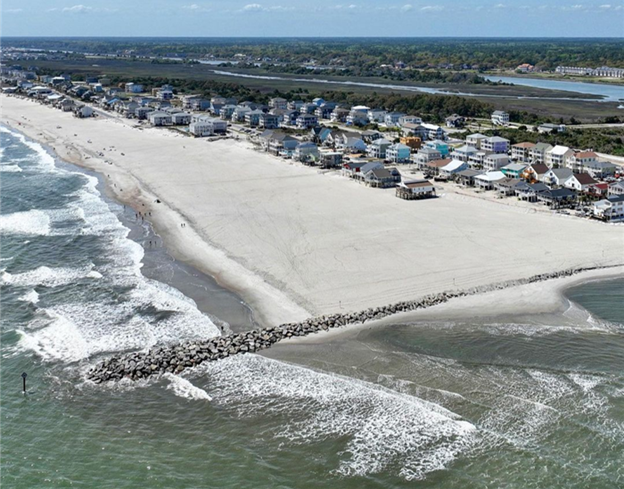
Holden Beach
The annual festival which started in the 1980’s occurs in April or May and is sponsored by the Greater Holden Beach Merchants Association. It’s the Holden Beach way to kick-off the Spring and start the vacation season. In addition to the food and arts & crafts, enjoy live music & entertainment, a horseshoe tournament and the world famous “Bopple Race”. Lots of activities for the entire family!
For more information » click here
 Brunswick County invites residents to participate in lifesaving certification training in 2026
Brunswick County’s Risk Management and Parks and Recreation departments are partnering to offer First Aid/CPR/AED Certification Training in 2026.
This training program is designed to provide residents with the knowledge and skills needed to recognize and respond appropriately to cardiac, breathing and first aid emergencies.
The training is open to any Brunswick County residents 12-years-old and up. Participants under 18-years-old must be accompanied by an adult guardian for the entire training session. Upon successful completion of the course, participants will receive an American Trauma Event Management (ATEM) First Aid/CPR/AED certification card, which is valid for two years.
There are only 12 seats available per training session and the registration fee is $10 per person. Participants must register and pay online here,
https://bcparks.recdesk.com/Community/Program, before the training date.
Each class will consist of an morning Session from 9 a.m. to 12 p.m., a 30-minute lunch break (participants must bring their own lunch and beverages) and an afternoon session from 12:30 p.m. to 3:30 p.m. Attendees must attend and complete both sessions to receive certification.
2026 First Aid/CPR/ AED Certification Training Sessions
Saturday, June 20, 2026 / Supply Area
-
- Location: Lockwood Folly Community Building
• 1691 Stanbury Rd SW, Supply, NC 28462 - Time: 9 a.m. to 3:30 p.m.
- Cost: $10 per person
- Registration opens March 1, 2026
- Location: Lockwood Folly Community Building
For questions or more information about the training program, email Brunswick County Risk Management.
![]() Discover a wide range of things to do in the Brunswick Islands for an experience that goes beyond the beach.
Discover a wide range of things to do in the Brunswick Islands for an experience that goes beyond the beach.
For more information » click here.
Calendar of Events Island
 Family Nighttime Easter Egg Hunt
The Town will hold its annual nighttime Easter Egg Hunt on Good Friday, April 3rd beginning at 7:00 p.m. Teams of four will compete against each other. Participants will need to bring their own flashlights and something to place their eggs in to the event. Participants MUST register by March 20th. Space is limited to the first 100 families. Email Christy at christy.ferguson@hbtownhall.com to register. Check-in on the evening of the event will be on the sidewalk in front of Town Hall.
 HBPOA Easter Membership Meeting
HBPOA membership meeting at 10:00 a.m. on Saturday, April 4th at Town Hall.
Guest speakers:
-
-
- Bryan Chadwick, Town Manager
- Holden Beach Turtle Patrol
- Resilient Coastal Communities Program (RCCP) team
-
 Easter Sunrise Service
Holden Beach Chapel is sponsoring an Easter Sunrise Service at 6:30 a.m. Easter Sunday, April 5th at the Holden Beach Pier.
Reminders
 Smoke Detectors
Time change means time to check smoke detectors, too. The fire department is encouraging people to test their smoke alarms and change the battery. Smoke alarms should be replaced every 10 years, whether they are battery-operated or hard-wired.
 Yard Waste Service
Yard debris pick-up will be provided twice a month on the second and fourth Fridays during the months of March, April, and May. Please have yard waste placed at the street for pick-up on Thursday night. The first pickup of the season is on March 13th. No pick-ups will be made on vacant lots or construction sites.
Debris must be placed in a biodegradable bag or bundled in a length not to exceed five (5) feet and fifty (50) pounds. Each residence is allowed a total of ten (10) items, which can include a combination of bundles of brush and limbs meeting the required length and weight and/ or biodegradable bags with grass clippings, leaves, etc.

Brunswick County Shred Event
Brunswick County will be hosting its spring free shred event at the Brunswick County Government Center on Saturday, April 18th. Brunswick County residents and/or property owners can dispose of any unneeded documents free of charge. Proof of Brunswick County residency or property ownership is required.
Brunswick County Governmental Center
3325 Old Ocean Hwy., Bolivia, NC 28422
 Free Cleanup Week (Tentative April 20th thru 24th)
The next Free Cleanup Week at the Brunswick County Landfill will take place typically the third full week in April. Brunswick County property owners and residents can dispose of all materials, except for regular household trash and hazardous waste, free of charge during Free Cleanup Week. Individuals can dispose of metal, tires, electronics, latex paint, clothing, shoes, used oil, oil filters, antifreeze, gasoline, fluorescent bulbs, used cooking oil, smoke detectors, household batteries, rugs, mattresses, furniture, and yard debris in their designated area at the Landfill during this week. Participants must show proof of Brunswick County property ownership or residency. Brunswick County accepts various items at the Brunswick County Landfill year-round at no charge to Brunswick County property owners and residents. See a full list of accepted items on the Accepted Items and Tipping Fees webpage. For questions, operationservices@brunswickcountync.gov or call 910-253-2520.
Location:
Brunswick County Landfill
172 Landfill Rd NE
Bolivia, NC 28422
Hours of Operation:
Monday through Friday 7:30 a.m. until 5:00 p.m.
Saturday 7:30 a.m. until 3:00 p.m.
For more information » click here
 News from Town of Holden Beach
The town sends out emails of events, news, agendas, notifications, and emergency information. If you would like to be added to their mailing list, please go to their web site to complete your subscription to the Holden Beach E-Newsletter.
For more information » click here
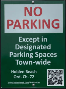
 Paid Parking
Paid parking in Holden Beach
Paid parking will be enforced from 9:00 a.m. to 5:00 p.m. daily with free parking before and after that time. All parking will use license plates for verification.
Rates
Parking rates for a single vehicle in all designated areas will be:
$5 per hour for up to four hours
$20 per day for any duration greater than four hours
$80 per week for seven consecutive days
Handicap Parking
A vehicle displaying a handicap license plate and/or hang tag parked in a designated handicap space is free. Any other parking space will require a parking permit via the app.
Annual Passes
Annual permits for the calendar year allow vehicles (this includes low-speed vehicles and trailers) access to designated parking.
$175 for a single vehicle
Passes can be purchased via the app, website or by telephone.
Where to Park
Per ordinance, there is no parking on the streets or rights-of-way except in designated parking spaces identified by Pay-to-Park signs. Click here to view an interactive map. The table with authorized parking can be viewed below.
Citations will be issued for:
-
-
- Parking without an active paid permit in a designated parking area
- Parking within 40 feet of a street intersection
- Parking in a crosswalk, sidewalk, or pedestrian access ways
- Parking blocking a driveway or mailbox
- Parking facing opposing traffic
- Parking in a no parking zone, or within right-of-way
- Parking on any portion of the roadway or travel lane
- Parking a non-LSV vehicle in an authorized LSV location
-
How Do I Pay to Park
The Town uses the SurfCAST by Otto Connect Mobile Solution. This is a mobile app downloadable for Apple and Android devices. Download the app today. Users will setup their account, enter their license plate details and pay for parking directly on the app. Alternatively, users can scan the QR Code located on the parking signs to access a secure website.
The Otto Connect customer service team will be available to help via phone and email.

Solid Waste Pickup Schedule
GFL Environmental change in service, October through May trash pickup will be once a week.
Please note:
Trash carts must be at the street by 6:00 a.m. on the pickup day
BAG the trash before putting it in the cart
Carts will be rolled back to the front of the house
GFL Refuse Collection Policy
GFL has recently notified all Brunswick County residents that they will no longer accept extra bags of refuse outside of the collection cart. This is not a new policy but is stricter enforcement of an existing policy. While in the past GFL drivers would at times make exceptions and take additional bags of refuse, the tremendous growth in housing within Brunswick County makes this practice cost prohibitive and causes drivers to fall behind schedule.
Solid Waste Pickup Schedule
starting October once a week
Recycling
starting October every other week pick-up
Curbside Recycling – 2026
GFL Environmental is now offering curbside recycling for Town properties that desire to participate in the service. The service cost per cart is $122.93 annually paid in advance to the Town of Holden Beach. The service consists of a ninety-six (96) gallon cart that is emptied every other week during the months of October – May and weekly during the months of June – September.
Curbside Recycling Application » click here
Curbside Recycling Calendar » click here

Trash Can Requirements – Rental Properties
GFL Environmental – trash can requirements
Ordinance 07-13, Section 50.08
Rental properties have specific number of trashcans based on number of bedrooms.
* One extra trash can per every 2 bedrooms
..
§ 50.08 RENTAL HOMES.
(A) Rental homes, as defined in Chapter 157, that are rented as part of the summer rental season, are subject to high numbers of guests, resulting in abnormally large volumes of trash. This type of occupancy use presents a significantly higher impact than homes not used for summer rentals. In interest of public health and sanitation and environmental concerns, all rental home shall have a minimum of one trash can per two bedrooms. Homes with an odd number of bedrooms shall round up (for examples one to two bedrooms – one trash can; three to four bedrooms – two trash cans; five – six bedrooms – three trash cans, and the like).
Upon Further Review
County proposes new fire service contract focused on performance, accountability
While Brunswick County continues working out how it will fund local fire service in the future, county commissioners on Jan. 20 were presented with an updated fire services agreement draft aimed at establishing performance standards and improving financial reporting standards for local nonprofit fire departments. The board did not vote on adopting the updated agreement on Jan. 20, instead providing county administration with feedback on the proposed changes. The primary changes outlined in the updated service contracts related to establishing performance standards for local fire departments and increasing financial accountability for departments that plan to accept additional funding the county plans to provide in the upcoming fiscal year, county staff explained. For over a year, Brunswick County has been investigating how to sufficiently fund in-county fire service following concerns about the existing fire fee funding model adequacy. Fire fees are imposed by the county on real property owners to fund the furnishing of fire protection services, per state law. Fire fees for improved properties are calculated based on a building’s heated square footage; fire fees for vacant land are calculated based on property acreage. Fire fees are not based on tax value. Many local nonprofit departments are facing challenges stemming from declining volunteer numbers necessitating most departments to hire paid staff, increasing costs and delivery time for fire apparatus and equipment, increased call volume and the need for new or updated facilities due to growth. These departments operate entirely on fire fees, grants, fundraising and private donations. Municipal departments are facing similar struggles related to growth and increased costs. These departments are funded partly by fire fees supplemented by ad valorem (property) taxes collected by each department’s municipality. As a potential solution, the county has been exploring moving away from its fire fee funding model to a fire tax funding model. With a fire tax model, counties can charge a 10-cent fire tax per $100 property value in each fire district or between 11- and 15-cents per $100 value with a voter-approved referendum. If the county moves to a fire tax system, citizens would no longer pay fire fees. Though this change is not planned for fiscal year 2026-2027, which begins July 1, county officials are working to prepare for a possible change in FY 2027-2028. In lieu of the funding model switch in FY 26-27, County Manager Steve Stone in November recommended the county revise its fire service funding contracts with local nonprofit departments to clarify its service expectations and require more financial accountability aimed at improving service across the county. The county is also considering providing between $10 million and $12 million in one-time supplemental funding to local departments to help meet service demands while a permanent solution is worked out. Stone said the $10-$12 million estimate is based on funding needed for minimum staffing levels at each department. The final subsidy funding figure will be calculated as part of the FY 26-27 budget process, he added. “It could be more. It could be less.” The county manager also explained fire departments would need to sign the finalized new services agreement “to be eligible to receive supplemental funding.” Brunswick County Spokesperson Meagan Kascsak said the current agreements between local fire departments and the county do not expire for another two fiscal years, and departments can continue operating under those agreements if they so choose. “However, if a department chooses this route, they will not be able to request subsidized funding for particular projects or purchases that their current fire fee allotment may not be able to cover,” Kascsak said. The new agreement contains a proposed stipulation requiring any equipment fire departments purchase with county-subsidized funds to be titled to Brunswick County and leased to respective fire departments, Kascsak confirmed. “Any existing equipment a fire department owns that was purchased in the past from their general fund/fire fees allocation, grant funding, donations, etc. will continue to belong to that fire department and will not be titled to the county,” she added. County staff has met with the Brunswick County Fire Chief’s Association to discuss the updated agreement and its provisions, Stone said. County officials following the Jan. 20 meeting were also set to meet with the municipal fire departments, he added, though these departments’ contracts differ and will apply to areas outside municipal fire departments’ corporate limits. The county manager during the Jan. 20 meeting explained the major changes in the proposed new agreement. “What we have here essentially are for the really the first time in the past 26 or 27 years or more, whereby we have some specific department performance standards which are based on national standards from the National Fire Protection Association for rural areas,” Stone said. “We also are moving towards more financial accountability with this agreement, but we would not really require additional financial work on the part of the departments. The additional auditing, we would propose that the county actually engage an auditor to do that work.” The proposed agreement also adds requirements related to response times, staffing, operational capabilities, required data collection and reporting that data to the county Fire Oversight Committee. Concerning response times, the proposed agreement requires fire departments to “make reasonable efforts to deliver the first-arriving unit and the minimum Effective Response Force (ERF) to emergency incidents within” 14 minutes or less from dispatch to arrival on-scene for structural fire suppression, and eight minutes or less from dispatch to arrival on-scene for single unit response. Departments would be expected to achieve these response times in “at least 80% of all emergency incidents occurring within the contract service area, measured annually.” If a department’s performance falls below the outlined 80% threshold, it would be required to: conduct a root-cause analysis with the county fire administrator and submit a written corrective action plan within 60 days identifying the deficiency and outlining corrective measures. Regarding response staffing, the proposed agreement would require a total of six “qualified firefighters” on the scene for fire suppression incidents requiring an initial attack capability within the required response times. Four of the six qualified firefighters would be required to be from the primary responding department. The proposed agreement defines “qualified firefighters” as “individuals of the department who meet the training and certification standards recognized by the department and applicable state and federal regulations for their assigned role.” Additionally, each department would be required to maintain records of dispatch times, turnout times, travel times, personnel counts upon arrival on scene, incident types and locations and any factors resulting in delayed or impaired response. Departments would also need to submit quarterly performance reports to the Brunswick County Fire Oversight Committee. Information contained in those reports include the percentage of incidents in which the departments met the 14-minute performance objective, staffing compliance data, analysis of deficiencies and contributing factors and performance improvement recommendations. The county would provide the software to each department for aforementioned data and records collection, Stone told the board. Brunswick County Fire Chiefs Association Vice President Keith McGee, who is also the Calabash Fire Department Chief, said the proposed agreement “represents several fundamental shifts in how fire service governance, performance expectations, and accountability are structured in Brunswick County,” noting the chief’s association is “not at this time expressing agreement with the contract as currently written.” McGee asked the county to continue conservation and collaboration with local fire departments and allow departments more time to review the agreement before bringing it to a vote. “We believe that this approach will help ensure a final agreement that is clear, workable, and supported by both the county and the fire departments that are responsible for delivering emergency services to our citizens,” he said. County administration is expected to bring an updated draft, incorporating board feedback and additional feedback from local fire departments to the board of commissioners during its Monday, Feb. 16 meeting at 6 p.m.
Read more » click here
Corrections & Amplifications
 OIB Terminal Groin
Ocean Isle Beach completed construction of a terminal groin on its east end in April 2022 to help protect the beach immediately behind it. However, this structure has contributed to significant erosion at the east end near Shallotte Inlet by interrupting natural longshore drift, prompting ongoing efforts such as sandbag use to prevent ocean encroachment on properties in that area.
2024 OIB SHORELINE AND INLET ANNUAL MONITORING REPORT
On Holden Beach, the recent volume change rates (May 2024 to November 2024) along the oceanfront shoreline indicated erosion at 12 of the 21 monitoring stations. Similarly, the MHW shoreline change rates indicated a shoreline retreat at 15 of the 21 monitoring stations. The long-term post-construction linear shoreline changes along the Holden Beach oceanfront shoreline indicated landward retreat. However, volumetric changes indicated slight accretion (0.2 cy/ft./yr.) within this area over the long-term period. The shoreline threshold analysis results along the Holden Beach oceanfront shoreline show that the post-construction shoreline change threshold was exceeded at only one monitoring station. This is the first time a threshold has been exceeded at Holden Beach since this annual analysis started in 2022. In addition, the analysis of May 2024 aerial imagery-derived wet/dry line revealed an 885 ft. section of Holden Beach’s inlet shoreline that exceeded the inlet shoreline threshold by a maximum distance of 100 feet. The inlet shoreline threshold on Holden Beach was also exceeded in Year-2. This marks two straight years where this threshold was exceeded. The inlet shoreline recession is believed to likely be attributed to a combination of morphological changes within Shallotte Inlet including the position and orientation of the main channel through Shallotte Inlet and the formation of a flood channel on the inlet shoulder of Holden Beach. Regardless, as stated in the Plan, because the shoreline changes in this area exceeded the threshold over the entire 2-year confirmation period, an assessment of the proper responsive measures will be made through coordination with State and Federal regulatory officials.
 Sand is vanishing on east side of Ocean Isles $11M erosion fix
When the Army Corps of Engineers issued its final decision on the terminal groin project here more than eight years ago, the document conveyed a prescient warning. A terminal groin may increase erosion along the easternmost point of Ocean Isle Beach, down-drift of the structure. Today, the shoreline east of terminal groin is being gnawed away, vanishing beach in front of a neighborhood of grand, multimillion-dollar homes built shortly after the $11 million erosion-control structure was completed in spring 2022. A wall of sandbags fends off waves from reaching some of the waterfront homes on the ocean side of the gated community that’s advertised as luxurious coastal living. Several lots remain vacant because the properties no longer have enough beachfront necessary to meet the state’s ocean setback requirements. I would have never developed the property if I had known this was going to happen,said Doc Dunlap, a developer with Pointe OIB, LLC. It’s just devastating to tell you the truth. I even had plans myself to build there, have a summer home.The caveat written in the federal record of decision all those years ago, one that was a central argument in a lawsuit to try and stop the terminal groin from being built, was not explicitly pointed out to the developers of The Pointe, they say. In an email responding to Coastal Review’s questions, the Division of Coastal Management said it, is not aware of any specific notification to those property owners other than the standard (area of environmental concern) hazard notice. We were just under the impression that all of this was going to be extremely positive and help protect this part of the beach, said Jimmy Bell, who contributed to the planning and implementation of the community. And then, once we started experiencing this massive erosion, I started researching groins more. We had engineers and other people that were helping, and we were informed and under the impression that it was going to all be good, and now it’s turning out to not be quite as good. Ocean Isle Beach Mayor Debbie Smith pushed back on those claims. My heart breaks for them, but the developers knew that that groin was going in, she said. They knew it was not designed to protect that area. It was not designed to harm it, but they also know that adjacent 2,000 feet west of them was a line of sandbags and most of them had been there for years. The developers are now seeking legal representation as they continue to try to figure out how to protect the oceanfront properties within the 44-lot neighborhood. Mr. Dunlap is extremely disappointed in the decisions made that resulted in the placement and construction of the terminal groin and the erosion damages it has caused,†John Hilton III, corporate counsel to Pointe OIB, stated in an email. He is committed to holding those who made these decisions legally accountable and also seeking a remedy to correct the ongoing erosion. We are working to obtain local legal counsel to explore and pursue all available options.
Erosion-battered shore
The east end of the island at Shallotte Inlet historically accreted and eroded naturally as the inlet wagged back and forth between Ocean Isle Beach and Holden Beach up until Hurricane Hazel hit in 1954. When the powerful hurricane, likely a Category 4 storm using the Saffir-Simpson scale developed in 1971, made landfall in October 1954 near the South Carolina border, it caused the inlet channel to move in a more easterly direction, accelerating erosion at the east end of the barrier island. Erosion has remained persistent in that area since the 1970s, according to N.C. Division of Coastal Management records. The worst of the erosion occurred along about a mile of oceanfront shore beginning near the inlet. An encroaching ocean claimed homes, damaged and destroyed public utilities, and prompted the N.C. Department of Transportation to abandon state-maintained streets. In 2005, the town was permitted to install at the east a wall of sandbags to barricade private properties and infrastructure from ocean waves. Sandbags revetments are, under state rules, to be used as a temporary measure to hold erosion at bay. In 2011, the North Carolina General Assembly repealed a decades-old state law that prohibited permanent, hardened erosion-control structures from being built on North Carolina beaches. Under the revised law, a handful of beach communities, including Ocean Isle Beach, get the option to pursue installing a terminal groin at an inlet area. Terminal groins are wall-like structures built perpendicular to the shore at inlets to contain sand in areas of high erosion like the east end of Ocean Isle Beach. These structures are controversial because they capture sand that travels down the beach near shore, depleting the sand supply to the beach immediately downdrift of the structure, stripping land that is natural habitat for, among others, sea turtles and shorebirds. Ocean Isle Beach Sea Turtle Protection Organization Island Coordinator Deb Allen said that beach conditions east of the terminal groin have hindered turtles from nesting there this season. Escarpment, sandbags and debris that Allen believes is coming from the development have impeded turtles from accessing the sandy areas they seek to lay their eggs. As of early September, the organization had recorded four false crawls, which is when a female turtle crawls onto a beach only to return to the ocean without laying eggs, and three nests east of the terminal groin, Allen said. The potential for that type of impact to wildlife was argued in a lawsuit the Southern Environmental Law Center filed on behalf of the National Audubon Society in August 2017 challenging the Corps approval of Ocean Isle Beach’s project. The lawsuit claimed that the Corps failed to objectively evaluate alternatives to the terminal groin, including those that would be less costly to Ocean Isle residents and less destructive to the coast, particularly to what was then the undeveloped area on the islands east end. The lawsuit, which later included the town, came to an end in March 2021 after a panel of appellate court judges affirmed a lower courts decision that the Corps fairly considered the alternatives included in an environmental impact statement, or EIS, examining the proposed project. As we went through and talked about the impacts of terminal groins in the EIS, this was the central argument will the land east of the groin erode at a more rapid pace? And, everything we could point to, all of the science, said yes, said Geoff Gisler, program director of SELC’s Chapel Hill office. There’s only so much sand and the way that these structures operate is they keep more of it in one place and necessarily take it from somewhere else. That’s why we have seen over and over again that when you build a groin towards the end of an island, what happens is the island erodes at the end. That there is less sand going to the east end is not an accident.
Righting this wrong
Gisler said the SELC will be following how the town and the Corps respond to the erosion that is occurring east of the terminal groin. The town committed and the Corps committed to righting this wrong if it occurred and that’s what we’ll be looking at, he said. Under conditions in the town’s federal permit, the town is required to monitor the sand spit east of The Pointe as well as the town’s shoreline and that of neighboring Holden Beach to the west. Should those shorelines erode past boundaries identified in 1999, consideration will be given to modifying the structure to allow more sediment to move from west to east past the structure,†according to final EIS. The town also has the option to nourish an eroded shoreline. In the event the negative impacts of the terminal groin cannot be mitigated with beach nourishment or possible modifications to the design of the terminal groin, the terminal groin would be removed, the EIS states. The Corps and the Division of Coastal Management are reviewing the monitoring report submitted by the engineering firm hired by the town, Coastal Protection Engineering of North Carolina. That report indicates that erosion has exceeded the 1999 shoreline threshold for the area immediately east of the groin. However, the applicant is working on a modification request to alter this threshold as the shoreline had eroded landward of part of that threshold prior to construction of the groin, according to the division. A beach maintenance project scheduled for fall 2026 to inject sand west of the terminal groin is anticipated to increase the rate of sand that bypasses the terminal groin and would serve to ˜feed the shoreline immediately east of the groin with additional material,†according to the town’s engineer. But The Pointe’s developers and property owners say they can’t wait another year. There’s got to be an exception to the standard application restrictions (i.e., sandbag placement and height) the (Coastal Area Management Act/Coastal Resources Commission) process has today to protect near term east of the groin due to emergency status and a path longer term that can get us to a point of evaluating what we can do for the groin from a redesign standpoint that would protect all both west and east of the groin, property owner Brendan Flynn said. What we’re dealing with now in my view is we need to have another review of what could be done to enhance the groin’s performance to benefit and protect the other part of this island. Smith said that the terminal groin is doing what it was designed to do. It is building up right adjacent to the groin, she said. It just has not built anything far enough down to protect this new development. I wish Mother Nature would reserve herself and build it up right now instead of taking it away. I wish I had some magic bullet for them too, but I don’t today. It’s really up to them to take some action. Kerri Allen, director of the North Carolina Coastal Federation’s southeast office in Wrightsville Beach, called the situation heartbreaking, but not surprising. The Coastal Federation publishes Coastal Review. When you alter the natural movement of sand with a hardened structure like the terminal groin, you might protect one stretch of beach, but you inevitably put other areas at greater risk, she said. And, unfortunately, the erosion we’re seeing east of the groin is exactly what experts warn could happen. That being said, the purpose of this groin was to protect existing infrastructure that was already at risk. Instead, new homes were built in an area that’s incredibly vulnerable and these homeowners are now facing devastating losses. Moving forward, we need to focus on solutions that don’t just shift the problem from one place to another and ensure that public resources aren’t used to subsidize these risky, short-term development decisions. I think this is a pivotal moment for Ocean Isle and for other coastal towns, she continued. We have an opportunity to step back, look at the science, and commit to managing our coast in a way that protects both our communities and the natural systems that sustain them. That means resisting the temptation to build our way out of these challenges because, ultimately, the ocean always wins.
Read more » click here

Town of Ocean Isle Beach provides update on East End erosion
The town of Ocean Isle Beach is evaluating response options after recent monitoring data showed erosion exceeded trigger points at the East End. Town officials said the shoreline is regularly monitored east of the terminal groin as required by state and federal permits. Monitoring determines when erosion or shoreline changes reach levels that require review and, if warranted, action. According to recent data, erosion has impacted a limited section just east of the terminal and has exceeded one of the trigger points. The town must work with agencies to consider how to address the erosion, with options including placing sand on the affected section or adjusting the terminal groin. “Importantly, this requirement is a condition of the Town’s permit issued in 2016. It applies regardless of nearby development, construction, or underlying cause of the erosion. This process is to ensure the Town follows the requirements included in the permits, which were approved after a multi-year public and regulatory review,” officials wrote in an announcement. Officials are working with the town’s engineering team, the N.C. Division of Coastal Management and the U.S. Army Corps of Engineers to review conditions and evaluate possible next steps. The requirements apply whether or not development exists nearby, officials said. If erosion limits are exceeded, the town is required to act regardless of adjacent properties. “Shorelines near inlets naturally change over time. Historical monitoring shows this area has experienced significant landward movement long before the terminal groin was built, which is why long-term monitoring and required responses were included in the permits,” town officials wrote. The erosion limits and monitoring requirements were established as part of the Shoreline and Inlet Management Plan approved by the N.C. Division of Coastal Management and the U.S. Army Corps of Engineers. Officials said doing nothing could place the town out of compliance with its permits and result in more erosion, higher future costs and fewer ways to address the problem later. Questions can be directed to Town Manager Justin W. Whiteside by phone or email.
Read more » click here

Erosion at Brunswick beach under review after major road washout
After a portion of a new beachfront community road washed away, erosion near the Ocean Isle Beach terminal groin could require action from local and federal agencies. On Jan. 6, the town of Ocean Isle Beach announced recent monitoring data showed erosion in a section east of the terminal groin has exceeded a point that now requires review and possible action from the town, along with state and federal agencies. The Pointe at Ocean Isle Beach is a new, gated “luxurious beach community,” per the development’s website. The community has 44 single family homes, some being oceanfront and marsh front homesites, according to the website. At the end of September and beginning of October 2025, part of The Pointe’s road began to wash out due to high tides and stormy weather. The washout only worsened as more of the road washed away. Homes have not been not damaged, but residents remain concerned, Cheek Team Real Estate Agent Cherri Cheek said. The homeowners are responsible for rebuilding the road, Cheek added. After living in the area for 40 years and seeing some erosion on Ocean Isle Beach’s east end, Cheek said this was the most amount of erosion she has seen at that location. There was once around 400 feet of beach beyond the residential lots, said Cheek, describing the recent erosion as “substantial.” Cheek worries a U.S. Army Corps of Engineers dredging project that never took place last March could have lowered the amount and impact of erosion. “I’m really disappointed that we had that much erosion there,” Cheek said. “The erosion caused one more lot to not be a buildable lot.”
Potential solutions are under review
Some residents believe the town allowed the development to build too close to the inlet. However, development near inlets are regulated by state and federal agencies. “If a project meets those regulations and receives approval, the town does not have the authority to deny it based solely because of its location near an inlet,” per the town’s website. “Shoreline management and development approvals are separate processes.” Recent annual monitoring data shows that erosion in that section is requiring action from the town, per the recent update. The town is working with its engineering team, the North Carolina Division of Coastal Management, and the U.S. Army Corps of Engineers to review conditions and evaluate next steps. Options to address the issue currently under review include, placing sand on the affected section of beach or making structural modifications to the terminal groin. Both options are outlined in the approved management plan. No final decision has been made as of Jan. 13. “We will continue to share updates as the process moves forward and appreciate the community’s interest in responsible shoreline management,” the town website states.
About the terminal groin
Days after the road began to wash away, Ocean Isle Beach Mayor Debbie Smith posted on the town’s Facebook page a timeline of the terminal groin project and The Pointe development. Smith stated the terminal groin project initial scoping meeting was in October 2012, noting construction of the terminal groin did not commence until November 2021, after the final environmental impact statement was completed and the Coastal Area Management Act permit issued. The Pointe development was first proposed and approved between 2015 and October 2016, Smith said. However, Smith said the Coastal Area Management Act permit issued in June 2018 was followed by a new sketch plan of the development in December 2019, Smith said. The final subdivision was approved in 2022, Smith said. The town regularly monitors shoreline conditions east of the terminal groin as required by state and federal permits. This monitoring follows set standards to determine when erosion or shoreline changes reach levels that require review and possible action, according to the town. “It applies regardless of nearby development, construction, or underlying cause of the erosion,” per the town’s website. “This process is to ensure the town follows the requirements included in the permits, which were approved after a multi-year public and regulatory review.”
Read more » click here
Ocean Isle seeks to modify permit, nourish beach at east inlet
Ocean Isle Beach hopes to pump tens of thousands of cubic yards of sand onto the beach at the easternmost tip of the island by this spring as an erosion stopgap. The Brunswick County town has asked the Army Corps of Engineers Wilmington District for authorization to have up to 70,000 cubic yards of sand placed east of its terminal groin where erosion has been chipping away at the shoreline in front of a luxury neighborhood. The Corps announced late last week that it is accepting public comments through March 8 on the town’s application to modify the federal permit it received in 2016 to build the terminal groin at Shallotte Inlet. As it stands, that permit does not allow sand to be placed east of the terminal groin. A terminal groin is a wall-like structure built perpendicular to the shore at inlets to contain sand in areas with high rates of erosion. Proposed modifications to the permit include placing sand along an 1,875-foot stretch of shoreline at The Pointe, a gated community whose oceanfront property owners have been desperately trying to hold back an encroaching sea. Under the terms of the proposed permit changes, this would be a one-time beach nourishment project. The town is also asking for its permitted sand borrow source in Shallotte Inlet to be expanded from about 83 acres to a little more than 117 acres, to add a new borrow area within the Atlantic Intracoastal Waterway and be allowed to work outside of the environmental window for dredging from April 30 to June 15. Ocean Isle Beach Town Manager Justin Whiteside said on Tuesday that the town wants to get the modified permit as quickly as possible in hopes that the sand placement project would coincide with a federal dredging project. The Corps announced last September it had awarded a nearly $8.5 million contract to maintenance dredge several areas along the Intracoastal, including at the Shallotte Inlet crossing. Whiteside explained that Ocean Isle Beach anticipates receiving 25,000 cubic yards of sand “that the town is paying for” from the Corps through the inlet crossing project. “The hope is to get this permit modified within the timeframe that the Corps’ contractor is here on site and then we could contract with them possibly to dredge more in that federal channel or go into that inlet borrow area to put that additional sand there,” he said. Whiteside said the town does not yet have an approximate cost of its proposal to nourish the beach east of the terminal groin. Ocean Isle’s east end had for decades been losing ground to chronic erosion, the worst of which occurred along about a mile of ocean shoreline beginning near the inlet. An encroaching ocean claimed homes damaged, destroyed public utilities, and prompted the North Carolina Department of Transportation to abandon state-maintained streets there. To stave off further erosion, the town in 2005 was permitted to install a wall of sandbags to protect private properties from getting swallowed up by the sea. In 2011, Ocean Isle Beach was, along with a handful of other beach communities, allowed to pursue the option of installing a terminal groin at an inlet area after the North Carolina General Assembly repealed a law that banned hardened erosion control structures on the state’s ocean shorelines. Five years later, the town received state and federal approval to build a 750-foot terminal groin. But before construction could begin, the Southern Environmental Law Center in August 2017 filed a lawsuit on behalf of the National Audubon Society challenging the Corps’ approval of the project. More than three years passed before the lawsuit, which later included the town, concluded after an appellate court affirmed a lower court’s decision that the Corps fairly considered the alternatives included in an environmental impact statement examining the proposed project. Construction of the $11 million project was completed in the spring of 2022, the same year the final plan for The Pointe, a 44-lot subdivision, was approved for development. By fall 2025, The Pointe’s oceanfront properties were suffering significant erosion. Last November, the North Carolina Coastal Resources Commission unanimously agreed to grant permission to the owners of eight lots in that neighborhood to install larger than typically allowed sandbag structures waterward of their land. Whiteside said Tuesday that those sandbags had not been installed. Sand in the area east of the terminal groin, he said, appears to be “recovering a little bit.” “We think over the past month and a half or so that we’ve gained, just looking at aerial photographs, approximately 5,000 cubic yards of sand that’s deposited east of the groin, so some of the beach is building back up in that area,” Whiteside said. He explained that in 2022 the town’s federal beach nourishment project took place in conjunction with the construction of the terminal groin. “The dredger came through and we had a huge spit on the east end of the island and that contractor came through and just dredged right through that spit and took it down to a negative 15-foot elevation,” Whiteside said. “It’s kind of filled back in now and we’re thinking that’s why we’re seeing the growth back east of the groin. We’re hoping this shows that that’s some of what contributed to it, that it was maybe our own nourishment project through the Corps.” “But, in the meantime, we know this is a short-term solution that we’ve got to figure out some type of long-term solution to, so our engineer firm is going to be doing some modeling to see what kind of modifications, if any, need to take place to the existing groin,” he continued. Comments on the proposed project should refer the permit application number (SAW-2011-01241) and may be submitted to the Corps electronically through the Regulatory Request System at https://rrs.usace.army.mil/rrs or by email to Tyler Crumbley at tyler.a.crumbley2@usace.army.mil . Written comments may be mailed to Commander, U.S. Army Corps of Engineers, Wilmington District, Attention: Tyler Crumbley, 69 Darlington Ave., Wilmington, NC 28403. The Corps will consider written requests for a public hearing to be held to consider the proposed application modifications.
Read more » click here
Odds & Ends
NC Justices hear case on Currituck occupancy tax spending
On Tuesday, Feb. 17, the North Carolina Supreme Court heard arguments in the long-running legal battle between Currituck County and the Corolla Civic Association (CCA) over how the county spends occupancy tax money. The CCA plaintiffs contend that the county has improperly used those funds to pay for police, fire protection, emergency services and equipment for public safety rather than earmarking them for tourism-related expenses. The Currituck County Commissioners, citing the extra needs placed on public safety in the summer tourist season in Corolla, have contended that state law allows public safety spending with those funds. The state legislature passes a law for any county that wishes to charge an occupancy tax, with a provision outlining how the tax can be used. The Currituck County occupancy tax law was first passed in 1987 and amended in 2004. The Outer Banks Voice – NC Supreme Court to hear Currituck County occupancy tax case In March 2024, the NC Court of Appeals Court ruled in favor of the CCA and members of the organization. Currituck County then appealed that ruling to the State Supreme Court. During the Feb. 17 arguments, it seemed clear that key elements of the case are whether public safety expenses are related to tourism and how much discretion the commissioners have in allocating occupancy tax dollars. In speaking first for the defendants, attorney Chris Geis of the Womble Bond Dickinson firm argued that under the statute, the “[Currituck] Commissioners were given the broad authority to use their judgment to determine what is a tourism-related expenditure” that brings tourism to the county. As an example, Geis cited occupancy tax spending on the county’s Veterans’ Memorial Park, which he said a “leaves people with a good feeling about [this] place. That is a tourism related expenditure.” He noted that the plaintiffs opposed spending occupancy tax dollars on the Park. “We have reasonable disagreement here, we understand that,” Geis said, in addressing the Supreme Court Justices. “But this is not an area where the county has stepped outside that line” of violating state law. Making the case for the plaintiffs, attorney Troy Shelton of the Dowling PLLC firm, stated that “the Court of Appeals saw exactly what happened for what it was,” in ruling for the plaintiffs. “The County’s been breaking the law, and it has to stop.” In response to one Justice’s question, Shelton said that “I don’t think that paying for police or firefighters attracts tourists.” “There is nothing stopping the County from going back to the [North Carolina] legislature and trying a new round of lobbying” to change the statute. “That’s what they need to be doing instead of fighting this case,” he stated. Asked by Chief Justice Paul Newby what remedies the plaintiffs are seeking if they prevail, Shelton indicated that among things, they want the restoration of the occupancy tax funds they say were improperly spent. You can see the Supreme Court arguments here. Supreme Court of North Carolina: 101PA24 Costanzo, et al. v Currituck County, et al.
Read more » click here
Editor’s note –
We currently use the occupancy tax funds to pay for all sorts of things that we claim are tourist related expenses too. It will be bad news for us if the County loses this case.
This and That
Brunswick adopts 100-year storm standard to curb flooding from future developments
New developments in Brunswick County will soon be held to a higher standard of flood protection, as local officials overhaul stormwater rules after repeated flooding issues have surfaced countywide. In a unanimous vote on Jan. 20, the Board of Commissioners approved updates to the county’s Stormwater Management Manual and Ordinance, raising the county’s stormwater standard from a 25-year to a 100-year storm event. The move followed public pressure in the wake of 2024’s Potential Tropical Cyclone 8, which many residents said indicated previous stormwater regulations were no longer sufficient. Developers have been required to design stormwater systems capable of managing runoff from storms expected to occur once every 25 years. Under the updated rules, almost all projects must now prove drainage infrastructure can handle storms with a 1% annual probability — commonly known as 100-year events — without increasing runoff beyond pre-development levels. Precipitation data from the National Oceanic and Atmospheric Administration indicates 100-year events in southeastern North Carolina can dump between 10 to 13 inches of rain over a 24-hour period. By comparison, 25-year storms produce about 7 to 9 inches of rain in the same time period. NOAA and National Weather Service analyses show heavy precipitation events are increasing in frequency and intensity across North Carolina, with studies projecting extreme rainfall — the heaviest 1% of storms — could become roughly 25% more intense by 2075. Deputy Engineering Services Director Bridget Flora noted many larger residential subdivision projects are often already meeting the 100-year storm standard voluntarily. However, making the requirement mandatory means all projects — commercial and residential — can no longer bypass the threshold without formal review. PTC8 was considered a 1,000-year event, bringing extreme rainfall to Brunswick County, with the National Weather Service reporting roughly 12 to 20 inches of rain across parts of the county. The storm caused widespread flooding and an estimated $50 million to $100 million in damages across southeastern North Carolina. Port City Daily asked Brunswick County for an updated estimate of PTC8 related spending. This will be updated upon response. The new ordinance does include an exemption for smaller project sites unable to physically meet the 100-year standard. For example, a coffee shop planned on a half-acre lot might not have the space to accommodate designing for a 100-year storm, which often requires larger retention ponds and more land devoted to drainage infrastructure. The small amount of land also must account for required parking, setbacks, and other needs. To qualify for an exemption, developers must demonstrate compliance would make a site undevelopable, while still meeting at least the 25-year storm threshold. Exemptions would first be reviewed by county staff, with appeals coming before commissioners for the final say. Only one resident spoke during Tuesday’s public hearing — Ernie McLaney, a volunteer spokesperson for Citizens for Better Brunswick. A local non-partisan advocacy group, it focuses on sustainable growth and infrastructure transparency. While favoring the 100-year timeline, McLaney criticized the new ordinance’s small-site exemptions, arguing it shifts long-term costs from developers to residents. “If exceptions are allowed, developers save money up front by avoiding full compliance, and then all citizens pay on the back end through stormwater fees, repairs, and damage recovery,” he said. He also highlighted the economic cost of flooding, citing FEMA research suggesting every $1 spent on mitigation saves approximately $6 in future recovery costs. McLaney argued that the cost of failing to mitigate can be higher when factoring in property and infrastructure damage, and business interruption. Commissioner Randy Thompson echoed McLaney’s concerns and initially moved to mandate the 100-year storm requirement for all projects, regardless of lot size. It received a spattering of applause from members of the public. On top of being a commissioner, Thompson is the chief executive officer of Thompson Disaster Recovery Associates Inc., which advises government agencies on disaster preparedness, recovery, and emergency management. He also served as Brunswick County’s emergency services director from 2000 to 2009. “If you’re in and can be impacted by the 100-year, why not build it to that and make sure that you are covered all the way around as far as the buildability of the land,” Thompson said. “I don’t see where the minimum design for the 25-year should even be in place.” However, county attorney Bryan Batton cautioned Thompson’s motion, explaining removing all exemptions could be considered as “government taking.” Simply stated, “taking” occurs when government regulations are so restrictive they strip a property of all practical or economic use. If the ordinance provides no path for relief or appeal, the owner could sue the county for the full value of the land. Multiple commissioners chimed in, asking staff what specifically constitutes a “small site” for exemption. Flora said they are not defined by a specific acreage but refer to compact commercial lots where meeting the 100-year standard would be difficult due to lot size. After debate, Thompson ultimately amended his motion to align with staff recommendation, maintaining exemptions for smaller sites unable to meet the standard due to technical constraints. To prevent retention ponds from consuming excessive buildable land, the updated rules allow developers to use emergency spillways — an outlet to release water from retention ponds during heavy rain. Developers can design ponds to hold the 100-year volume, but they are allowed to use a reinforced spillway to “bleed off” excess water in a controlled manner during extreme events, rather than requiring the pond walls to be built high enough to contain the entire surge. Although emergency spillways were not previously required under the county’s stormwater rules, they have been commonly included in engineering designs. In practical terms, the change allows developers to meet the 100-year standard without dedicating as much land to retention ponds, while still reducing flood risk. The regulation change comes as the county is also exploring the possibility of implementing a stormwater utility department, which would be funded through a dedicated fee paid by property owners. The fee would support maintenance and improvements to stormwater infrastructure, including drainage and retention systems. Stormwater management is currently handled by county engineering and public works departments, with costs covered through the county general fund and state and federal grants. A feasibility study for the utility fund is underway, though a proposal has yet to come before the board.
Read more » click here
Fauna & Flora –

NC State Native Plant Resources » click here
NC Native Plants for Pollinators » click here
NC Sea Grant Coastal Landscapes » click here
New Hanover County Arboretum Native Plant Garden » click here
Audubon Native Plant Database » click here
North Carolina Extension Gardener Plant Toolbox » click here
Fauna & Flora » click here
Holden Beach recommended plant list – deer resistant & salt tolerant
Factoid That May Interest Only Me
 History of The Intracoastal Waterway
Many people know the Intracoastal Waterway as a home to canal houses, a place to cruise a boat without the rough waters of the open ocean, or a center stage for water sports in beach towns up the east coast. But they may not know the history of the 3,000 mile inland waterway. The ICW as it’s known stretches from Boston, Massachusetts down to the coast of Florida and into the gulf coast, ending in Brownsville, Texas. The developers of the waterway incorporated naturally occurring rivers, inlets, sounds, and bays and connecting them with man-made channels. The purpose of the waterway was to improve transportation routes for circumnavigation using minimal ocean travel.
A Big Idea
The improvement of the country’s natural transportation routes was a major concern for all geographic regions and from a national perspective of building and binding the nation. In 1802, at the request of the Senate, Treasury Secretary Albert Gallatin presented a plan for future transportation developments. Gallatin’s plan covered the details of engineering, construction, and costs, including the national benefits to accrue from lowered transportation costs between domestic and international markets. His full $20 million, 10-year plan was never approved. With the War of 1812 highlighting the need for better water transportation, Gallatin’s plan was brought back into view. In 1824, the General Survey Act made a detailed analysis of the rivers, harbors, and sounds provided a sound base for the Intracoastal Waterway began to form. By this time, the United States Army Corps of Engineers took responsibility for waterway improvements and maintenance. In 1826, Congress decided to allow for the first survey for a canal on the inland side, between the Gulf and the ocean which also led to the growth of steam power for transportation on both land and sea. The coastal improvements continued going forward, but things suffered when the Civil War concluded. There also became a larger priority in railroad transportation over water transport. However, water transport maintained an advantage over railroads by providing a larger hauling capacity.
The Need For More in the 1900s
Once the 20th century rolled around, the diesel engine had just been invented and was being used in transportation fuels from coal and steam. Fuel consumption was up and studies began to find the most efficient methods for moving cargo. Now that the established channels were deepened, steering improved and usage increased. And at the same time, the Panama Canal Act was passed to revive waterway transportation in the US. Opening the Panama Canal for coastal shipping made an easy route to the west coast. When World War I exploded, there was a desperate need for bulk cargo transport and Congress established the Federal Barge Lines to create cheaper ways to transport supplies. The waterway flourished and expanded in the 1920s with the construction of both Louisiana and Texas Intracoastal Waterways. The final push for the completed Intracoastal Waterway came during World War II. German submarines sank numerous merchant ships off the East Coast, which spotlighted the driving urgency to have the waterway connect the way between New Orleans and Corpus Christi, making the majority of the continental US reachable within its own borders.
The ICW Today
Currently, the law requires a minimum depth of 12 feet throughout the waterway, but funding has been an issue. Many shallow sections exist with depths around 7 to 9 feet. Fuel taxes are charged since there are no tolls and this helps to maintain facilities. The first fuel tax was imposed in 1978 which started at 4¢ per gallon. Since then it has been raised to 20¢ starting in 1995. To collect and administer these taxes and funds the federal government created the Inland Waterways Trust Fund under the US Treasury, which is used to cover half the cost of new construction and major rehabilitation of the inland waterways infrastructure. The waterway is used today for a good amount of commercial activity, but of course, also for recreational purposes. Boatowners often sail up and down the ICW in Summer and Winter, preferring to navigate the waterway rather than the open ocean. The waterway also allows access to major ports in popular cities and states such as Savannah, Mississippi, Alabama, Delaware, and, of course, North Carolina Beaches.
Read more » click here
This NC destination is the No. 1 ‘most desirable’ place to live, US report finds North Carolina is home to the most desirable place to live in the United States, a new report finds.
Brunswick County ranks No. 1 on a list of top counties people have considered calling home, according to results the website U.S. News & World Report last updated in late January. “The Southern region of the U.S. has by far the most sought-after relocation destinations in our research,” U.S. News wrote in its report. “Mild temperatures, coastal living and year-round outdoor activities are likely driving this interest, though lower costs of living, with more affordable housing, may also factor into this.” Brunswick County is located along the coast in the southeastern corner of North Carolina. The destination topped the national list after U.S. News said it studied the ratio of people moving into and out of counties across the country. It also considered the places that people looked up online in 2025, focusing on searches that indicated their interest in moving.
Which other NC counties rank high?
Brunswick County — which has roughly 167,000 residents — is home to the popular waterfront destinations of Oak Island, Ocean Isle Beach and Southport. It wasn’t the only North Carolina destination to make its mark on the national list.
Here’s how other counties fared in the top 50 rankings:
-
-
- Catawba County at No. 7
- Gaston County at No. 10
- Johnston County at No. 14
- New Hanover County at No. 24
- Henderson County at No. 27
- Wake County at No. 36
- Union County at No. 39
- Alamance County at No. 44
- Buncombe County at No. 48
- Iredell County at No. 50
-
And here are some other North Carolina highlights from the U.S. News rankings:
-
-
- North Carolina at No. 4 for most desirable states
- Apex at No. 10 for most desirable cities
-
Why people are dreaming about NC?
So, what makes North Carolina so attractive? It’s a mix, with U.S. News saying people may be drawn to jobs, the state’s relative affordability or other factors. “The South Atlantic region includes popular vacation and retirement spots and plenty of natural beauty, coinciding with outdoor recreation opportunities like boating and golfing,” U.S. News wrote, adding that the South dominated the list of places potential movers were dreaming about. It’s not the first time North Carolina was named one of the hottest states. In 2024, the real estate website Clever also ranked it among the top places drawing people’s interest in moving, The News & Observer reported.
Read more » click here
 Brunswick County named most desirable place to move in the US
If you feel like more and more transplants are populating the Wilmington area, the research says you wouldn’t be wrong. Inward migration has been a prominent theme behind the Wilmington area’s recent population growth. Both Wilmington and the state of North Carolina have been highlighted as top moving destinations over the past few years. Recent data from U.S. News and World Report found that North Carolina was the fourth most sought-after state to move to, reflecting the general trend of more and more migration to the South. U.S. News’ research examined online search trends and population-adjusted move-in-to-move-out ratios to reveal which states, counties and cities Americans are actively considering for relocation. But the real kicker comes from U.S. News’ list of counties with the highest migration interest. Brunswick County topped the list of all counties across the United States, making it the most desirable county to move to, according to U.S. News.
Is Brunswick County the best place to move to?
Brunswick County’s No. 1 ranking can be attributed to several factors. For one, trends show that people across the country are migrating to the South at a far higher rate than anywhere else. Forty-five of the top 50 counties in U.S. News’ report were in the South, and six southern states were in the top 10. Leland in Brunswick County was also the No. 12 most desirable city to move to. But Brunswick County’s top ranking was also carried by its proximity to other major metros that were incredibly popular in the rankings. This includes Conway, South Carolina (Ranked No. 1), Myrtle Beach, South Carolina (No. 3), and Wilmington (No. 24). U.S. News attributed the South’s popularity to mild temperatures, coastal living and year-round outdoor activities — all factors that Brunswick County shines in.
Is North Carolina the best state to move to?
The report ranked North Carolina as the No. 4 most popular state to move to. Looking deeper, North Carolina also had nine cities and 11 counties in the top 50 of their respective categories. According to U.S. News, many of North Carolina’s strong qualities are a mirror of Brunswick County’s, including mild weather and natural beauty.
Read more » click here
Storm Events
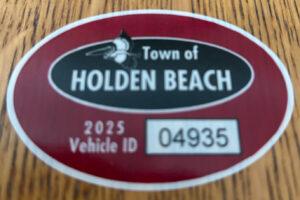 Hurricane Vehicle Decals
Property owners were provided with four (4) decals that were included in this month’s water bill. It is important that you place your decals in your vehicle or in a safe place. A $10 fee will be assessed to anyone who needs to obtain either additional or replacement decals. Decals will not be issued in the 24-hour period before an anticipated order of evacuation.
The decals are your passes to get back onto the island to check your property in the event that an emergency would necessitate restricting access to the island. Decals must be displayed in the driver side lower left-hand corner of the windshield, where they are not obstructed by any other items. Officials must be able to clearly read the decal from outside the vehicle.
Property owners without a valid decal will not be allowed on the island during restricted access. No other method of identification is accepted in an emergency situation. Click here to visit the Town website to find out more information regarding decals and emergency situations.
NC General Statute 166A-19.22
Power of municipalities and counties to enact ordinances to deal with states of emergency.
Synopsis – The governing body may impose by declaration or enacted ordinance, prohibitions, and restrictions during a state of emergency. This includes the prohibition and restriction of movements of people in public places, including imposing a curfew; directing or compelling the voluntary or mandatory evacuation of all or part of the population, controlling ingress and egress of an emergency area, and providing for the closure of streets, roads, highways, bridges, public vehicular areas. All prohibitions and restrictions imposed by declaration or ordinance shall take effect immediately upon publication of the declaration unless the declaration sets a later time. The prohibitions and restrictions shall expire when they are terminated by the official or entity that imposed them, or when the state of emergency terminates.
Violation – Any person who violates any provisions of an ordinance or a declaration enacted or declared pursuant to this section shall be guilty of a Class 2 misdemeanor.
Hot Button Issues
Subjects that are important to people and about which they have strong opinions

Climate
For more information » click here.
There’s something happening here
What it is ain’t exactly clear

Flood Insurance Program
For more information » click here

National Flood Insurance Program: Reauthorization
Congress must periodically renew the NFIP’s statutory authority to operate. On February 3, 2026, the president signed legislation passed by Congress that extends the National Flood Insurance Program’s (NFIP’s) authorization to September 30, 2026.
Congress must now reauthorize the NFIP
by no later than 11:59 pm on September 30, 2026.

GenX
For more information » click here

Homeowners Insurance
For more information » click here
NC Rate Bureau proposes nearly 70% increase on dwelling insurance policies
Living along the coast is already expensive, and now the cost could be going even higher if it’s not your primary residence. The North Carolina Rate Bureau (NCRB) is proposing an average rate increase of 68.3% for dwelling insurance policies, a move that would affect vacation homes, rental properties, and other non-primary residences across the state. North Carolina Insurance Commissioner Mike Causey said he opposed the proposal from the start. “In this case, in my view, this is excessive,” Causey said. The increase would be implemented over two years. In the first year, consumers would see a 28.5% increase, then a 30.9% increase in the second year. A $400,000 dwelling policy averages $2,071 per year. This increase would make it jump to roughly $3,479 per year. If the proposed increase were to take effect, the first hike would take effect on July 1, 2026, with the second on July 1, 2027. Causey says the biggest reason for the jump is inflation, rising claim costs, and insurance fraud cases going up. To clarify, there is a difference between dwelling insurance and homeowners’ insurance. Dwelling insurance usually covers homes that are not your primary residence.
Such policies are often purchased for the following types of properties:
-
-
- Vacation homes
- Vacant homes
- Seasonal homes
- Secondary homes
- Rental properties
- Older homes
-
When Causey was initially presented with the proposal, he says he said no. “So, what happens when you say no, you’re required to go to court,” said Causey. Because the rate bureau and Department of Insurance are separate and the power lies with the state agency, the two often reach settlements that produce significantly less extreme policy increases. A hearing is still scheduled for May 4 to work toward a resolution. However, the Department of Insurance and the NCRB can negotiate a settlement beforehand. “We’re in talks right now,” said Causey. “I can’t talk about the negotiations, but we’re hopefully to come up with something that would be favorable.” The last NCRB dwelling rate increase filing was in July 2023, requesting an average statewide 50.6% increase. A settlement was negotiated, resulting in an average 8% increase. “When you can cut more than two-thirds of what they were trying to raise, that puts money back in your pocket, and consumers can live with something reasonable,” said Causey.
In the wake of the proposed rate increase, the North Carolina Rate Bureau released the statement below:
“By its nature, insurance tries to manage risk in a wide range of situations, so there are many different types of property insurance policies. Dwelling policies generally cover rental properties owned by landlords as well as vacation homes, as opposed to primary homes that the owner lives in.
Primary homes are covered by homeowners’ policies and will not be affected by this filing. The NC Rate Bureau reviewed data on tens of thousands of actual insurance claims from 2019 through 2023 to determine the premiums needed to cover risks and build this request. We’ve asked for a substantial increase in the dwelling rate because claim costs have increased substantially. Climate change is here, and so are the financial costs from it. The 27 separate billion-dollar disasters that hit the United States in 2024 would have been an all-time record, had it not been for the 28 billion-dollar disasters that hit in 2023. Adding to these costs: Inflation in the construction industry has far outpaced overall inflation in recent years, and some of the fastest-growing areas in North Carolina are coastal areas where storm damage is more common. Simply put, severe storm damage is becoming more common, it’s impacting more homes, and it’s more expensive to rebuild afterwards. The Rate Bureau tries to strike a balance between affordable rates, rates that cover the risks to properties, and rates that encourage a large number of insurance carriers to compete for business in North Carolina. Finally, whatever rates the Department of Insurance approves, customers should not necessarily expect their premiums to increase by that amount. Rates vary by geography, by carrier, and based on how each insurance carrier assesses an individual property’s risk. The rate-setting process we’re engaged in with the Department of Insurance caps premiums that property insurance carriers charge, but the actual premiums are set on a case-by-case basis.”
Read more » click here

Hurricane Season
For more information » click here
Hurricane season runs from June 1 through November 30

Inlet Hazard Areas
For more information » click here
.
Lockwood Folly Inlet
For more information » click here.
Spring dredging scheduled for Shallotte, Lockwood Folly inlets
The United States Army Corps of Engineers (USACE) is scheduled to dredge the Lockwood Folly Inlet in March and the Shallotte Inlet in April. The dredged sand from the projects will be placed on both Holden Beach and Ocean Isle Beach, USACE Project Manager Bob Keistler said. Keistler attended the Feb. 18 Brunswick Shoreline Protection Consortium meeting to give an update to local public leaders on the federal projects recently completed or scheduled in Brunswick County. Just days before the meeting, the USACE completed placing sand on Oak Island after it dredged the Wilmington Harbor. Oak Island gained about 1.5 million cubic yards of sand, Keistler said. “In this case, the town of Oak Island … has provided additional funds,” Keistler said. “So while we were there, we were able to put some more sand on the beach there. They got about 600,000 yards that they paid for with their money, and then we paid for the other 900,000 yards.” The USACE is in the process of removing equipment from the beach, Keistler said. Another dredge is currently at Carolina Beach, but it will soon move on to dredge the Lockwood Folly Inlet crossing in March so that it is navigable to the Intracoastal Waterway, Keistler said. “We’re happy to hear that we’re still on schedule for March,” Holden Beach Assistant Town Manager Christy Ferguson said. She noted that the town plans to dredge its canals from November 2026 to January 2027. After Lockwood Folly, the USACE’s dredge will go to the Shallotte Inlet and place sand on Ocean Isle Beach, Keistler said. The contractor is planning to finish by the end of April. However, to give the project a time cushion, USACE is requesting an extension for placement of sand on Ocean Isle Beach past the environmental window, Keistler said. The USACE will dump an estimated total of 60,000 cubic yards of sand on the Ocean Isle Beach strand. It will place 35,000 cubic yards west of the terminal groin, and 25,000 cubic yards will go on the backside of the island, Keistler said. The USACE’s planned dredge will not place sand on the far east end of Ocean Isle Beach where erosion crept up to a luxury housing subdivision last October. The erosion has retreated slightly in the winter months, but homes may be vulnerable this coming hurricane season. “When we dredge the material out of the waterway,” Keistler said, “we want to put it on an adjacent beach with a permit where it doesn’t come right back into our spot. So the material that we’re paying for with our money, we’re putting on the western side of the terminal groin.” Ocean Isle Beach Town Manager Justin Whiteside said the town is in the process of requesting permission to place sand east of the terminal groin. It must address the increased erosion in that spot because of a monitoring clause in the groin’s permit, Whiteside said. “We had to monitor if those thresholds were exceeded,” Whiteside said, “and we have to do some type of mitigation effort.” The town of Ocean Isle Beach, in addition to USACE, is asking permission from the state to dredge outside of the environmental window, which ends April 30. The town hopes to complete the additional dredging at the same time the USACE dredges the Shallotte Inlet, Whiteside said. “That will be a short-term mitigation measure,” Whiteside said. “We’re also engaged with our engineer to look at long-term mitigation measures to hopefully ensure that those erosion thresholds don’t get breached in the future. That could be anything from shortening the terminal groin, lowering it a little bit by removing rocks or it could be placing something else out in the water.” Sunset Beach Councilwoman Christie Batchelor said that Sunset Beach has entered an agreement with Coastal Protection Engineering for phase two of the Jinks Creek realignment project. While the town has no trouble with erosion on the beachfront, the back side of the island’s east end has become slim where it meets the bank of Jinks Creek. This erosion has affected the Palm Cove gated community. The Palm Cove homeowners association entered a memorandum of agreement with the town to solve the issue. The project will be fully funded by state grant funds and Palm Cove HOA funds, The Brunswick Beacon reported. “They have a lot of sand bags out there right now to stop erosion,” Batchelor said, “but long term strategies are being looked at to try to alleviate the [erosion] where the homes are.” The next Brunswick Shoreline Protection Consortium meeting is scheduled for 10 a.m. on May 20.
Read more » click here

Seismic Testing / Offshore Drilling
For more information » click here.

Offshore Wind Farms
For more information » click here
Things I Think I Think
 Eating out is one of the great little joys of life.
Restaurant Review:
The Dinner Club visits a new restaurant once a month. Ratings reflect the reviewer’s reaction to food, ambience and service, with price taken into consideration.
/////
Name: Manna
Cuisine: New American
Location: 123 Princess Street, Wilmington NC (downtown)
Contact: 910.763.5252 / https://www.mannaavenue.com/
Food: Average / Very Good / Excellent / Exceptional
Service: Efficient / Proficient / Professional / Expert
Ambience: Drab / Plain / Distinct / Elegant
Cost: $32 Inexpensive <=20 / Moderate <=26 / Expensive <=35 / Exorbitant <=60
Rating: Four Stars
Opened in the fall of 2010, Manna is touted as one of the best restaurants in Wilmington for fine dining. This is one of the top restaurants with high quality farm-to-table food in the area. They offer a very limited menu, only five (5) entrees, that changes frequently. Manna’s seasonal menu has imaginative entrees with amusing dish names, using local ingredients, served in a relaxed yet sophisticated ambiance. The bar area deserves mentioning and was one of the best we’ve ever been to. Although it is one of our perennial favorite restaurants we had not been here for a few years. They didn’t disappoint, I’m happy to report they have maintained their high standards. They exceeded our expectations, what a delightful dining experience. I would recommend putting it on your short-list of must try restaurants.
Downtown Wilmington destination restaurant named one of the best in US
Popular Wilmington restaurant was named one of the best in the country.
Here’s everything to know before you go.
In Wilmington, manna restaurant is already a favorite for locals and visitors for their elevated, ever-changing menu. But this week? It’s made national news. According to USA TODAY’s 2026 Restaurants of the Year list, the downtown mainstay is one of the top 39 places to eat in America. “It’s awesome,” said Billy Mellon, owner of the restaurant, of the accolade “We always want to do the best we can at what we do.”
What makes manna stand out
Mellon opened manna in a historic 1906 building with the idea of providing a restaurant that offered excellent service and food. “We’ve just gotten through our 15th year, which is saying something,” he said. For the past six years, Chef Carson Jewell has been leading the kitchen. Jewell is a local musician who plays in a band with his wife, twin brother and a local dobro player. He’s also spent a lot of time in restaurants, including working as a sous chef at James Beard Award-winner Ashley Christensen’s Raleigh restaurant Death & Taxes. He said the experience that was most profound, though, was his time at Drifter’s Wife with Chef Ben Jackson in Portland, Maine. “That’s where I learned that I can do refined but also be myself and make the food that I want to make,” he said. He now orders food from a dozen or so farmers and purveyors. The kitchen staff bakes bread and makes everything from sauces to sausages in house. Jewell’s Southern roots can be seen on the menu, and he’s been offering a weekly comfort food special on Tuesday nights. It’s usually his version of brined-and-fried chicken. On Sunday nights, the sous chef helms a special omakase-style experience twice a month. Beggars Can’t Be Choosers allows diners to only order by category, like veggie, seafood, or miscellaneous. It always sells out.
What to order at manna
Oysters. Mellon said it was Jewell who convinced him to add oysters to the menu on a regular basis — but he’s convinced as are their oyster-loving regulars. Jewell sources his bivalves exclusively from the local Middle Sound Mariculture oyster farm, accentuates them with rotating accompaniments like pickled onion sorbet and apple mignonette.
Something from the bar. Mellon is refurbishing the onsite basement cellar that stocks thousands of bottles of around 700 wines. And the mixologists create seasonal cocktails. Mellon also hosts visiting mixologists and recently had a Sommelier in Residency, Evan Itzkowitz from the acclaimed The Little Nell in Aspen, Colorado.
“Surprise me.” The menu is purposely designed with several smaller plates, so even if you don’t have a reservation for Beggars Can’t Be Choosers, you can ask your server with help designing a four or five course experience, Mellon said. “You can always say ‘Surprise me, and get something exceptional,’” he said. “That’s the kind of restaurant we are.”
Insider tip: The hospitality group behind manna also owns Bougie Nights, a music venue and event space next door. Sister businesses include the private craft cocktail bar, Earnest Money & Sons, and the Greenfield Lake Yacht Club dive bar at 1756 Carolina Beach Road in Wilmington.
Details: 123 Princess St., Wilmington.
https://mannaavenue.com/, Instagram: @mannawilmington.
Read more » click here

Old places, New faces
Name: Rustic Crumb Company
Location: 3056 Holden Beach Road, Supply NC
Contact: 910.664.8587 / NA
https://www.facebook.com/people/Rustic-Crumb-Company/61581708551176/
“Bakery & Coffee Bistro – featuring a creative twist on sourdough breads, artisan loaves, pastries, scones, desserts and a cozy coffee bar.”
COMING SOON
We are diligently working with the County to get the building through the final steps of inspection and passed so we can open our doors. Currently we are now set to open our doors on April 1st.
Although it is not officially open yet,
I did get a Rosemary sourdough loaf bread which was delightful.

Old places, New faces
Name: Co•No•Mo
Location: 2633 Holden Beach Road, Supply NC
Contact: 910.846.2633 / https://www.facebook.com/holdenbeachcove/
The Cove Restaurant closed its doors in February. However, new signs are already up for the new Co•No•Mo which is described as a coastal café and lounge with a shared‑use commissary kitchen.
Dining Guide – Local * Lou’s Views
Dining Guide – North * Lou’s Views
Dining Guide – South * Lou’s Views
Restaurant Reviews – North * Lou’s Views
Restaurant Reviews – South * Lou’s Views
Book Review:
Read several books from The New York Times best sellers fiction list monthly
Selection represents this month’s pick of the litter
 THE TIN MEN by Nelson DeMille
This is the third entry in the series of military thriller novels featuring Scott Brodie and Maggie Taylor, special agents in the Army’s Criminal Investigation Division. This time out they are investigating a suspicious death at a secret Army base in the Mojave Desert where AI-powered robot soldiers (“tin men”) are being tested. They are assigned to figure out what went wrong with the lethal autonomous weapons and whether it was there criminal liability or intent, or was it a tragic accident?
That’s it for this newsletter
See you next month
Lou’s Views . HBPOIN
-
-
-
-
-
-
-
-
-
- Gather and disseminate information
- Identify the issues and determine how they affect you
- Act as a watchdog
- Grass roots monthly newsletter since 2008
-
-
-
-
-
-
-
-